Alvin Jewett Johnson: Johnson’s Hindostan or British India. ()
ศิลปิน/ผู้สร้างสรรค์งาน
Alvin Jewett Johnson (1827–1884)
ชื่ออื่น
A. J. Johnson
คำอธิบาย
American publisher และ cartographer
วันเกิด/วันเสียชีวิต
23 กันยายน พ.ศ. 2370
22 เมษายน พ.ศ. 2427
สถานที่เกิด/สถานที่เสียชีวิต
Wallingford
บรุกลิน
สถานที่สร้างสรรค์งาน
นครนิวยอร์ก
งานควบคุมรายการหลักฐาน
: Q18507750
VIAF: 77223115
ISNI: 0000 0001 1936 4486
Open Library: OL5738492A
LCCN: n82243699
GND: 123476186
WorldCat
artist QS:P170,Q18507750
ชื่อเรื่อง
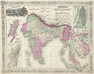
Johnson’s Hindostan or British India.
คำอธิบาย
English: A very nice example of A. J. Johnson’s 1864 map of India and Southeast Asia. Covers from the Indus River eastward to include all of India, Burma, Siam (Thailand), Laos, Cambodia, Malaysia (Malacca) and Vietnam (Tonquin and Chochin). Also includes parts of Pakistan, Nepal, China, Bhutan, Sumatra and Ceylon (Sri Lanka). Offers color coding according to country and region as well as notations regarding roadways, cities, towns, and river systems. Three inset maps focus on the Island of Bombay (Mumbai), Madras, and Calcutta. An view of the Government House and Treasury in Calcutta adorns the upper left corner. Features the fretwork style border common to Johnson’s atlas work from 1864 to 1869. Published by A. J. Johnson and Ward as plate number 95 in the 1864 edition of Johnson’s New Illustrated Family Atlas. This is the last edition of the Johnson Atlas to bear the Johnson and Ward imprint, subsequent editions were attributed to Johnson exclusively.
วันที่
2406 หรือ 2407 (undated)
ขนาด
ความสูง: ๑๓.๐ in (๓๓.๐ cm); ความกว้าง: ๑๗.๐ in (๔๓.๑ cm)
dimensions QS:P2048,13U218593
dimensions QS:P2049,17U218593
รหัสการถึอครอง
Geographicus link: India-j-64
ที่มา/ผู้ถ่ายภาพ
Johnson, A. J., Johnson's New Illustrated Family Atlas of The World with Physical Geography, and with Descriptions Geographical, Statistical, and Historic including The Latest Federal Census, A Geographical Index, and a Chronological History of the Civil War in America, 1864.
This file was provided to Wikimedia Commons by Geographicus Rare Antique Maps, a specialist dealer in rare maps and other cartography of the 15th, 16th, 17th, 18th and 19th centuries, as part of a cooperation project.
العربيَّة | Deutsch | English | suomi | français | македонски | Nederlands | polski | +/−
ایلون جے جانسن کا بنایا ہوا ہندوستان یا برطانوی ہند کا نقشہ، 1864ء
خريطة إيلون ج. جونسون للهند أو الهند البريطانية ، ١٨٦٤
یک نمونه بسیار زیبا از نقشه ۱۸۶۴ آ. ج. جانسون از هند و آسیای جنوب شرقی. پوششهایی از رودخانه سند به سمت شرق شامل تمام هند، برمه، سیام (تایلند)، لائوس، کامبوج، مالزی (مالکا) و ویتنام (تونکوین و چوچین) میشود. همچنین شامل بخشهایی از پاکستان، نپال ..
{{subst:User:Multichill/Geographicus |link=http://www.geographicus.com/P/AntiqueMap/India-j-64 |product_name=1864 Johnson's Map of India (Hindostan or British India) |map_title=Johnson’s Hindostan or British India. |description=A very nice example of A.
ไฟล, 1864, johnson, india, hindostan, british, india, geographicus, india, ไฟล, ประว, ไฟล, หน, าท, ภาพน, การใช, ไฟล, วนกลางขนาดของต, วอย, างน, กเซล, ความละเอ, ยดอ, กเซล, กเซล, กเซล, กเซล, กเซล, ภาพท, ความละเอ, ยดส, งกว, 8206, กเซล, ขนาดไฟล, เมกะไบต, ชน, ดไมม, . ifl prawtiifl hnathimiphaphni karichiflswnklangkhnadkhxngtwxyangni 753 599 phikesl khwamlaexiydxun 302 240 phikesl 603 480 phikesl 965 768 phikesl 1 280 1 019 phikesl 2 500 1 990 phikesl duphaphthimikhwamlaexiydsungkwa 8206 2 500 1 990 phikesl khnadifl 1 63 emkaibt chnidimm image jpeg rupphaphhruxiflesiyngni tnchbbxyuthi khxmmxns raylaexiyddanlang epnkhxkhwamthiaesdngphlcak ifltnchbbinkhxmmxns khxmmxnsepnewbistinokhrngkarsahrbekbrwbrwmsuxesri thi khunsamarthchwyid Alvin Jewett Johnson Johnson s Hindostan or British India nbsp nbsp nbsp silpin phusrangsrrkhngan Alvin Jewett Johnson nbsp 1827 1884 nbsp nbsp nbsp chuxxun A J Johnson khaxthibay American publisher aela cartographer wnekid wnesiychiwit 23 knyayn ph s 2370 nbsp 22 emsayn ph s 2427 nbsp sthanthiekid sthanthiesiychiwit Wallingfordbruklin sthanthisrangsrrkhngan nkhrniwyxrk nbsp ngankhwbkhumraykarhlkthan Q18507750 VIAF 77223115 ISNI 0000 0001 1936 4486 Open Library OL5738492A LCCN n82243699 GND 123476186 WorldCat artist QS P170 Q18507750 chuxeruxng Johnson s Hindostan or British India khaxthibay English A very nice example of A J Johnson s 1864 map of India and Southeast Asia Covers from the Indus River eastward to include all of India Burma Siam Thailand Laos Cambodia Malaysia Malacca and Vietnam Tonquin and Chochin Also includes parts of Pakistan Nepal China Bhutan Sumatra and Ceylon Sri Lanka Offers color coding according to country and region as well as notations regarding roadways cities towns and river systems Three inset maps focus on the Island of Bombay Mumbai Madras and Calcutta An view of the Government House and Treasury in Calcutta adorns the upper left corner Features the fretwork style border common to Johnson s atlas work from 1864 to 1869 Published by A J Johnson and Ward as plate number 95 in the 1864 edition of Johnson s New Illustrated Family Atlas This is the last edition of the Johnson Atlas to bear the Johnson and Ward imprint subsequent editions were attributed to Johnson exclusively wnthi 2406 hrux 2407 undated khnad khwamsung 13 0 in 33 0 cm khwamkwang 17 0 in 43 1 cm dimensions QS P2048 13U218593dimensions QS P2049 17U218593 rhskarthuxkhrxng Geographicus link India j 64 thima phuthayphaph Johnson A J Johnson s New Illustrated Family Atlas of The World with Physical Geography and with Descriptions Geographical Statistical and Historic including The Latest Federal Census A Geographical Index and a Chronological History of the Civil War in America 1864 This file was provided to Wikimedia Commons by Geographicus Rare Antique Maps a specialist dealer in rare maps and other cartography of the 15th 16th 17th 18th and 19th centuries as part of a cooperation project العربي ة nbsp Deutsch nbsp English nbsp suomi nbsp francais nbsp makedonski nbsp Nederlands nbsp polski nbsp karxnuyat karichiflniihm phaphniepnphaphthiekidcakkarthasaenaphaphhruxsilpkrrmsxngmiti sungtwphaphtnchbbthithukthasannepnsatharnsmbtidwyehtuphltxipni Public domain Public domain false false nganniepnsatharnsmbti inpraethstnkaenidaelapraethsxun thirayaewlakarkhumkhrxnglikhsiththinxykwa 100 pihlngcakphusrangsrrkhnganesiychiwit nganniepnsatharnsmbtiinshrthxemrika enuxngcakidrbkarephyaephr hruxkhuncdthaebiyntxsanknganlikhsiththiaehngshrth kxnwnthi 1 mkrakhm kh s 1928 iflniidthukrabuwaimmikhxcakdphayitkdhmaylikhsiththi rwmthungsiththithiekiywkhxngaelathiiklekhiyngknhttps creativecommons org publicdomain mark 1 0 PDM Creative Commons Public Domain Mark 1 0 false false mulnithiwikiphiediymimummxngxyangepnthangkarinkrniniwa karthasaenaphaphhruxsilpkrrmsxngmitithiepnsatharnsmbti thuxwaphaphthiidcakkarthasaenaepnsatharnsmbti karxangphlngandngklawepnnganswnbukhkhlepnkarkhdtxaenwkhidekiywkbsatharnsmbti sahrbkhxmulephimetim duthi emuxidcaichpay PD Artkarthasaenakhxngphaphnisungepnsatharnsmbti thuxidwaphaphthiekidcakkarthasaenaepnsatharnsmbtiechnkn oprdthrabwakarnaphaphniipichxacthukcakdhruxhamichinekhtxanacsalkhxngthan thngnikhunkbkdhmaythxngthinthibngkhbichinphunthinn duephimthi karnaphaphhruxsilpkrrmsxngmitiipichkhabrryayodyyxithyephimkhabrryaythrrthdediywephuxkhyaykhwamwaiflnimixairxngkvsmap shows name as hindostanxurduایلون جے جانسن کا بنایا ہوا ہندوستان یا برطانوی ہند کا نقشہ 1864ءxahrbخريطة إيلون ج جونسون للهند أو الهند البريطانية ١٨٦٤epxresiyیک نمونه بسیار زیبا از نقشه ۱۸۶۴ آ ج جانسون از هند و آسیای جنوب شرقی پوشش هایی از رودخانه سند به سمت شرق شامل تمام هند برمه سیام تایلند لائوس کامبوج مالزی مالکا و ویتنام تونکوین و چوچین می شود همچنین شامل بخش هایی از پاکستان نپال ixethmthiaesdngxyuiniflniprakxbdwyfxsfxrskarekbrwbrwmGeographicus Rare Antique Maps nbsp xngkvsMIME type nbsp xngkvsimage jpegchecksum nbsp xngkvs1867d1dc564a4be6e5b0968b9e0ed63cbcea7d78withikarkahnd SHA 1 nbsp xngkvsdata size nbsp xngkvs1 708 241 ibtkhwamsung1 990 phikeslkhwamkwang2 500 phikesl prawtiifl khlikwnthi ewlaephuxduiflthipraktinkhnann wnthi ewlarupyxkhnadphuichkhwamehn pccubn16 44 16 minakhm 25542 500 1 990 1 63 emkaibt BotMultichill subst User Multichill Geographicus link http www geographicus com P AntiqueMap India j 64 product name 1864 Johnson 039 s Map of India Hindostan or British India map title Johnson s Hindostan or British India description A very nice example of A hnathimiphaphni hnatxipni oyngmathiphaphni hindusthan karichiflswnklang wikixuntxipniichiflni karichbn ar wikipedia org هندستان karichbn azb wikipedia org هیندوستان karichbn en wikipedia org Hindustan karichbn fa wikipedia org هندوستان karichbn incubator wikimedia org Wp syl ꠢ ꠘ ꠖ ꠍ ꠔ ꠘ karichbn it wikipedia org Hindustan karichbn ml wikipedia org ഹ ന ദ സ ഥ ൻ karichbn nl wikipedia org Hindoestan regio karichbn ps wikipedia org هندوستان karichbn ru wiktionary org Indostan karichbn sd wikipedia org ھندستان karichbn skr wikipedia org ہندوستان karichbn sr wikipedia org Hindustan karichbn ta wikipedia org இந த ஸ த ன karichbn ur wikipedia org ہندوستان karichbn zh wikipedia org 印度斯坦 ekhathungcak https th wikipedia org wiki ifl 1864 Johnson 27s Map of India Hindostan or British India Geographicus India j 64 jpg, wikipedia, วิกิ หนังสือ, หนังสือ, ห้องสมุด,