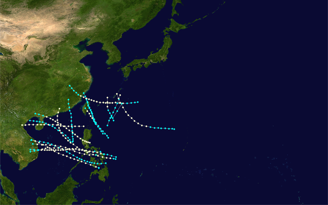
English: This map shows the tracks of all tropical cyclones in the 1900 Pacific typhoon season. The points show the location of each storm at 6-hour intervals. The colour represents the storm's maximum sustained wind speeds as classified in the Saffir-Simpson Hurricane Scale (see below), and the shape of the data points represent the type of the storm.
ไฟล, 1900, pacific, typhoon, season, summary, ไฟล, ประว, ไฟล, หน, าท, ภาพน, การใช, ไฟล, วนกลางขนาดของต, วอย, างน, กเซล, ความละเอ, ยดอ, กเซล, กเซล, กเซล, กเซล, กเซล, กเซล, ภาพท, ความละเอ, ยดส, งกว, 8206, กเซล, ขนาดไฟล, เมกะไบต, ชน, ดไมม, image, ปภาพหร, อไฟล, เส. ifl prawtiifl hnathimiphaphni karichiflswnklangkhnadkhxngtwxyangni 800 500 phikesl khwamlaexiydxun 320 200 phikesl 640 400 phikesl 1 024 640 phikesl 1 280 800 phikesl 2 560 1 600 phikesl 4 000 2 500 phikesl duphaphthimikhwamlaexiydsungkwa 8206 4 000 2 500 phikesl khnadifl 5 emkaibt chnidimm image png rupphaphhruxiflesiyngni tnchbbxyuthi khxmmxns raylaexiyddanlang epnkhxkhwamthiaesdngphlcak ifltnchbbinkhxmmxns khxmmxnsepnewbistinokhrngkarsahrbekbrwbrwmsuxesri thi khunsamarthchwyid khwamyx khaxthibay1900 Pacific typhoon season summary png English This map shows the tracks of all tropical cyclones in the 1900 Pacific typhoon season The points show the location of each storm at 6 hour intervals The colour represents the storm s maximum sustained wind speeds as classified in the Saffir Simpson Hurricane Scale see below and the shape of the data points represent the type of the storm Saffir Simpson scale Tropical depression 38 mph 62 km h Tropical storm 39 73 mph 63 118 km h Category 1 74 95 mph 119 153 km h Category 2 96 110 mph 154 177 km h Category 3 111 129 mph 178 208 km h Category 4 130 156 mph 209 251 km h Category 5 157 mph 252 km h Unknown Storm type Tropical cyclone Subtropical cyclone Extratropical cyclone Remnant low Tropical disturbance Monsoon depressionaehlngthima Created using WikiProject Tropical cyclones Tracks The background image is from NASA 1 The tracking dataphusrangsrrkh Supportstorm Public domain Public domain false falsenganniidthukephyaephrsusatharnsmbtiodyecakhxng Supportstorm sungmiphlthwolkinbangpraeths karkrathadngklawxacimsamarththaidtamkdhmaySupportstorm xnuyatihthukkhnmisiththiinkarichiflniinthukehtuphlkarich odyimmimienguxnikh ewnaetkdhmayimxnuyatihthaechnnnkhabrryayodyyxithyephimkhabrryaythrrthdediywephuxkhyaykhwamwaiflnimixairixethmthiaesdngxyuiniflniprakxbdwysthanalikhsiththicopyrighted dedicated to the public domain by copyright holder xngkvssyyaxnuyatreleased into the public domain by the copyright holder xngkvs prawtiifl khlikwnthi ewlaephuxduiflthipraktinkhnann wnthi ewlarupyxkhnadphuichkhwamehn pccubn09 18 24 knyayn 25614 000 2 500 5 emkaibt Supportstorm Hurricane season auto track map start June 19 end November 16 source IBTrACS type typhoon basin Pacific year 1900 author Supportstorm hnathimiphaphni hnatxipni oyngmathiphaphni phayuitfunaepsifik karichiflswnklang wikixuntxipniichiflni karichbn en wikipedia org 1900 Pacific typhoon season karichbn es wikipedia org Temporada de tifones en el Pacifico de 1900 karichbn pt wikipedia org Temporada de tufoes no Pacifico de 1900 karichbn vi wikipedia org Mua bao Tay Bắc Thai Binh Dương 1900 ekhathungcak https th wikipedia org wiki ifl 1900 Pacific typhoon season summary png, wikipedia, วิกิ หนังสือ, หนังสือ, ห้องสมุด,