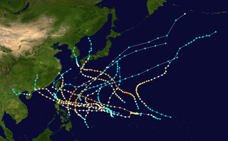
English: This map shows the tracks of all tropical cyclones in the 1946 Pacific typhoon season. The points show the location of each storm at 6-hour intervals. The colour represents the storm's maximum sustained wind speeds as classified in the Saffir-Simpson Hurricane Scale (see below), and the shape of the data points represent the type of the storm.
Created using WikiProject Tropical cyclones/Tracks. The background image is from NASA [1]. The tracking data is from the Joint Typhoon Warning Center's best track database
ผู้สร้างสรรค์
Iune
This file may be updated to reflect new information. If you wish to use a specific version of the file without new updates being mirrored, please upload the required version as a separate file.
{{Information |Description=This map shows the tracks of all tropical cyclones in the w:1946 Pacific typhoon season. {{PD-user|Nilfanion}} |Source= |Date= |Author= |Permission= |other_versions= }} [[Category:Pacific typhoon
ไฟล, 1946, pacific, typhoon, season, summary, ไฟล, ประว, ไฟล, หน, าท, ภาพน, การใช, ไฟล, วนกลางขนาดของต, วอย, างน, กเซล, ความละเอ, ยดอ, กเซล, กเซล, กเซล, กเซล, กเซล, กเซล, ภาพท, ความละเอ, ยดส, งกว, 8206, กเซล, ขนาดไฟล, เมกะไบต, ชน, ดไมม, image, ปภาพหร, อไฟล, เส. ifl prawtiifl hnathimiphaphni karichiflswnklangkhnadkhxngtwxyangni 800 494 phikesl khwamlaexiydxun 320 198 phikesl 640 396 phikesl 1 024 633 phikesl 1 280 791 phikesl 2 560 1 582 phikesl 6 000 3 708 phikesl duphaphthimikhwamlaexiydsungkwa 8206 6 000 3 708 phikesl khnadifl 11 5 emkaibt chnidimm image png rupphaphhruxiflesiyngni tnchbbxyuthi khxmmxns raylaexiyddanlang epnkhxkhwamthiaesdngphlcak ifltnchbbinkhxmmxns khxmmxnsepnewbistinokhrngkarsahrbekbrwbrwmsuxesri thi khunsamarthchwyid khaxthibay1946 Pacific typhoon season summary png English This map shows the tracks of all tropical cyclones in the 1946 Pacific typhoon season The points show the location of each storm at 6 hour intervals The colour represents the storm s maximum sustained wind speeds as classified in the Saffir Simpson Hurricane Scale see below and the shape of the data points represent the type of the storm Saffir Simpson scale Tropical depression 38 mph 62 km h Tropical storm 39 73 mph 63 118 km h Category 1 74 95 mph 119 153 km h Category 2 96 110 mph 154 177 km h Category 3 111 129 mph 178 208 km h Category 4 130 156 mph 209 251 km h Category 5 157 mph 252 km h Unknown Storm type Tropical cyclone Subtropical cyclone Extratropical cyclone Remnant low Tropical disturbance Monsoon depressionaehlngthima Created using WikiProject Tropical cyclones Tracks The background image is from NASA 1 The tracking data is from the Joint Typhoon Warning Center s best track databasephusrangsrrkh Iune This file may be updated to reflect new information If you wish to use a specific version of the file without new updates being mirrored please upload the required version as a separate file Public domain Public domain false falsenganniidthukephyaephrsusatharnsmbtiodyecakhxng Iune sungmiphlthwolkinbangpraeths karkrathadngklawxacimsamarththaidtamkdhmayIune xnuyatihthukkhnmisiththiinkarichiflniinthukehtuphlkarich odyimmimienguxnikh ewnaetkdhmayimxnuyatihthaechnnnkhabrryayodyyxithyephimkhabrryaythrrthdediywephuxkhyaykhwamwaiflnimixairixethmthiaesdngxyuiniflniprakxbdwysthanalikhsiththicopyrighted dedicated to the public domain by copyright holder xngkvsmilikhsiththisyyaxnuyatreleased into the public domain by the copyright holder xngkvs prawtiifl khlikwnthi ewlaephuxduiflthipraktinkhnann wnthi ewlarupyxkhnadphuichkhwamehn pccubn21 46 7 mithunayn 25566 000 3 708 11 5 emkaibt SupportstormHigher resolution 07 59 5 kumphaphnth 25531 024 633 548 kiolibt Iunebetter points 04 19 3 singhakhm 25503 000 1 895 529 kiolibt NilfaBot Information Description This map shows the tracks of all tropical cyclones in the w 1946 Pacific typhoon season PD user Nilfanion Source Date Author Permission other versions Category Pacific typhoon hnathimiphaphni hnatxipni oyngmathiphaphni phayuitfunaepsifik karichiflswnklang wikixuntxipniichiflni karichbn en wikipedia org 1946 Pacific typhoon season karichbn zh wikipedia org 1946年太平洋颱風季 ekhathungcak https th wikipedia org wiki ifl 1946 Pacific typhoon season summary png, wikipedia, วิกิ หนังสือ, หนังสือ, ห้องสมุด,