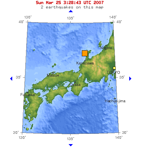
Map of Magnitude 6.7 earthquake in near the west coast of honshu([[w:Noto Peninsula|]]),Japan, 2007-03-25. Source : [https://earthquake.usgs.gov/eqcenter/recenteqsww/Maps/10/135_35.php] {{PD-USGov-USGS}}
ไฟล, 2007, japan, noto, earthquake, ไฟล, ประว, ไฟล, หน, าท, ภาพน, การใช, ไฟล, วนกลางไม, ภาพท, รายละเอ, ยดส, งกว, าน, 2007, japan, noto, earthquake, 8206, กเซล, ขนาดไฟล, โลไบต, ชน, ดไมม, image, ปภาพหร, อไฟล, เส, ยงน, นฉบ, บอย, คอมมอนส, รายละเอ, ยดด, านล, าง, เป. ifl prawtiifl hnathimiphaphni karichiflswnklangimmiphaphthimiraylaexiydsungkwani 2007 03 25 Japan Noto earthquake png 8206 456 499 phikesl khnadifl 29 kiolibt chnidimm image png rupphaphhruxiflesiyngni tnchbbxyuthi khxmmxns raylaexiyddanlang epnkhxkhwamthiaesdngphlcak ifltnchbbinkhxmmxns khxmmxnsepnewbistinokhrngkarsahrbekbrwbrwmsuxesri thi khunsamarthchwyid Map of Magnitude 6 7 earthquake in near the west coast of honshu Noto Peninsula Japan 2007 03 25 Source 1 Public domain Public domain false falseThis image is in the public domain in the United States because it only contains materials that originally came from the United States Geological Survey an agency of the United States Department of the Interior For more information see the official USGS copyright policy Bahasa Indonesia catala cestina Deutsch eesti English espanol francais galego italiano Nederlands portugues polski sicilianu suomi Tiếng Việt Turkce blgarski makedonski russkij മലയ ള 한국어 日本語 中文 中文 简体 中文 繁體 العربية فارسی bnthukkarxphohld wnthi ewla khnad phuich khwamehn25 minakhm ph s 2550 05 53 01 456 499 33284 bytes Pekachu khuy swnrwm Map of Magnitude 6 7 earthquake in near the west coast of honshu w Noto Peninsula Japan 2007 03 25 Source https earthquake usgs gov eqcenter recenteqsww Maps 10 135 35 php PD USGov USGS prawtiifl khlikwnthi ewlaephuxduiflthipraktinkhnann wnthi ewlarupyxkhnadphuichkhwamehn pccubn16 40 21 krkdakhm 2557456 499 29 kiolibt GifTaggerBot Converting file to superior PNG file Source 2007 03 25 Japan Noto earthquake gif This GIF was problematic due to non greyscale color table hnathimiphaphni hnatxipni oyngmathiphaphni aephndinihwinkhabsmuthronota kh s 2007 karichiflswnklang wikixuntxipniichiflni karichbn en wikipedia org 2007 Noto earthquake karichbn ja wikipedia org 2007年の気象 地象 天象 能登半島地震 2007年の日本 karichbn ja wikinews org ウィキニュース 2007年 3月 ウィキニュース 2007年 3月 25日 短信 2007年 3月 25日 石川県で震度6強 2007年3月25日 karichbn www wikidata org Q986103 ekhathungcak https th wikipedia org wiki ifl 2007 03 25 Japan Noto earthquake png, wikipedia, วิกิ หนังสือ, หนังสือ, ห้องสมุด,