ภาพธรณีวิทยานี้ ควรจะถูกสร้างใหม่เป็นกราฟิกส์เวกเตอร์ ซึ่งมีข้อดีอีกหลายประการ ดูเพิ่มเติมที่คอมมอนส์:สื่อต้องการเก็บกวาดสำหรับสารสนเทศเพิ่มเติม หากภาพนี้มีในรูปแบบกราฟิกส์เวกเตอร์อยู่แล้ว กรุณาอัปโหลดและแทนที่แม่แบบนี้ด้วย {{vector version available|ชื่อภาพใหม่}} แนะนำเป็นอย่างยิ่งให้ตั้งชื่อไฟล์เวกเตอร์ใหม่นั้นในรูปแบบ "2008TC3-groundpath-rev.svg" แล้วใส่แม่แบบ Vector version available (หรือ Vva) ซึ่งไม่ต้องใช้พารามิเตอร์ ชื่อภาพใหม่
คำอธิบาย2008TC3-groundpath-rev.png
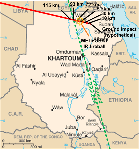
English: Ground track and probable explosion point in midair of the asteroid 2008 TC3 which entered earth's atmosphere and exploded over Sudan on 2008-10-06.
Original map CIA Factbook. Graphic overlay George William Herbert 2008-10-07. GFDL and CC-BY-3.0 dual licensed.
Ground track from Very near NEO Meteoroid (Mike Kretlow); infrasound track from [1] (Dr Peter Brown); IR fireball location from [2] and [3] (EUMETSAT). The infrasound map image can also be found at [4].
วันที่
แหล่งที่มา
Own work modifications to US Government PD / CIA Factbook map of Sudan
ผู้สร้างสรรค์
George William Herbert (graphic overlay) / US Government (original map)
{{Information |Description={{en|1=will update after uplaod}} |Source=US Gov / own work |Author=US GOV + own work |Date= |Permission= |other_versions= }} <!--{{ImageUpload|full}}-->
ไฟล, 2008tc3, groundpath, ไฟล, ประว, ไฟล, หน, าท, ภาพน, การใช, ไฟล, วนกลางไม, ภาพท, รายละเอ, ยดส, งกว, าน, 2008tc3, groundpath, 8206, กเซล, ขนาดไฟล, โลไบต, ชน, ดไมม, image, ปภาพหร, อไฟล, เส, ยงน, นฉบ, บอย, คอมมอนส, รายละเอ, ยดด, านล, าง, เป, นข, อความท, แสดงผล. ifl prawtiifl hnathimiphaphni karichiflswnklangimmiphaphthimiraylaexiydsungkwani 2008TC3 groundpath rev png 8206 537 579 phikesl khnadifl 232 kiolibt chnidimm image png rupphaphhruxiflesiyngni tnchbbxyuthi khxmmxns raylaexiyddanlang epnkhxkhwamthiaesdngphlcak ifltnchbbinkhxmmxns khxmmxnsepnewbistinokhrngkarsahrbekbrwbrwmsuxesri thi khunsamarthchwyid enuxha 1 khwamyx 2 karxnuyatichsiththi 2 1 Original map 2 2 Graphic overlay khwamyx phaphthrniwithyani khwrcathuksrangihmepnkrafiksewketxr sungmikhxdixikhlayprakar duephimetimthikhxmmxns suxtxngkarekbkwadsahrbsarsnethsephimetim hakphaphnimiinrupaebbkrafiksewketxrxyuaelw krunaxpohldaelaaethnthiaemaebbnidwy vector version available i chuxphaphihm i aenanaepnxyangyingihtngchuxiflewketxrihmnninrupaebb 2008TC3 groundpath rev svg aelwisaemaebb Vector version available hrux Vva sungimtxngichpharamietxr chuxphaphihmkhaxthibay2008TC3 groundpath rev png English Ground track and probable explosion point in midair of the asteroid 2008 TC3 which entered earth s atmosphere and exploded over Sudan on 2008 10 06 Original map CIA Factbook Graphic overlay George William Herbert 2008 10 07 GFDL and CC BY 3 0 dual licensed Ground track from Very near NEO Meteoroid Mike Kretlow infrasound track from 1 Dr Peter Brown IR fireball location from 2 and 3 EUMETSAT The infrasound map image can also be found at 4 wnthi 7 tulakhm ph s 2551aehlngthima Own work modifications to US Government PD CIA Factbook map of Sudanphusrangsrrkh George William Herbert graphic overlay US Government original map karxnuyatichsiththi Original map Public domain Public domain false falseThis image is in the public domain because it contains materials that originally came from the United States Central Intelligence Agency s World Factbook Bahasa Indonesia cestina Deutsch eesti English espanol Esperanto francais galego hrvatski italiano Nederlands norsk nynorsk polski portugues sicilianu slovenscina suomi Turkce Zazaki belaruskaya tarashkevica makedonski russkij srpski srpski ukrayinska ქართული ব ল தம ழ മലയ ള 한국어 日本語 中文 中文 简体 中文 繁體 العربية Graphic overlay xnuyatihkhdlxk aeckcayaela hruxddaeprexksarniphayitenguxnikhkhxngsyyaxnuyatexksaresrikhxngknu run 1 2 hruxrunid nbcaknithixxkodymulnithisxftaewresri odyimmiswnidhamaekikh immikhxkhwampkhnaaelapkhlng saenakhxngsyyaxnuyatrwmxyuinswnchux syyaxnuyatexksaresrikhxngknuhttp www gnu org copyleft fdl html GFDL GNU Free Documentation License true trueiflnixyuphayitsyyaxnuyatkhriexthifkhxmmxns run aesdngthima 3 0 tnchbbkhunsamarth thicaaebngpn thicathasaena aeckcay aelasngngandngklawtxip thicaeriyberiyngihm thicaddaeplngngandngklaw phayitenguxnikhtxipni aesdngthima khuntxngihekiyrtiecakhxngnganxyangehmaasm odyephimlingkipyngsyyaxnuyat aelarabuhakmikarepliynaeplng khunxacthaechnniidinrupaebbidkidtamkhwr aettxngimichinlksnathiaenawaphuihxnuyatsnbsnunkhunhruxkarichngankhxngkhunhttps creativecommons org licenses by 3 0 CC BY 3 0 Creative Commons Attribution 3 0 true truekhabrryayodyyxithyephimkhabrryaythrrthdediywephuxkhyaykhwamwaiflnimixairixethmthiaesdngxyuiniflniprakxbdwysthanalikhsiththimilikhsiththisyyaxnuyatGNU Free Documentation License version 1 2 or later xngkvsCreative Commons Attribution 3 0 Unported xngkvswnthisrang wnkxtng7 tulakhm 2008 prawtiifl khlikwnthi ewlaephuxduiflthipraktinkhnann wnthi ewlarupyxkhnadphuichkhwamehn pccubn06 08 10 tulakhm 2551537 579 232 kiolibt Georgewilliamherbert Information Description en 1 will update after uplaod Source US Gov own work Author US GOV own work Date Permission other versions lt ImageUpload full gt hnathimiphaphni hnatxipni oyngmathiphaphni 2008 TC3 karichiflswnklang wikixuntxipniichiflni karichbn ar wikipedia org التنبؤ باصطدام الكويكبات karichbn bg wikipedia org 2008 TC3 karichbn de wikipedia org 2008 TC3 karichbn en wikipedia org 2008 TC3 Asteroid impact prediction karichbn en wikiversity org User Marshallsumter Radiation astronomy Asteroids User Marshallsumter Radiation astronomy1 Meteoroids User Marshallsumter Radiation astronomy Fieries karichbn fi wikipedia org 2008 TC3 karichbn hu wikipedia org 2008 TC3 karichbn ja wikipedia org 2008 TC3 karichbn lb wikipedia org 2008 TC3 karichbn nl wikipedia org 2008 TC3 karichbn pl wikipedia org 2008 TC3 karichbn ru wikipedia org 2008 TC3 karichbn scn wikipedia org 2008 TC3 karichbn simple wikipedia org Asteroid impact prediction karichbn sv wikipedia org 2008 TC3 karichbn vi wikipedia org 2008 TC3 ekhathungcak https th wikipedia org wiki ifl 2008TC3 groundpath rev png, wikipedia, วิกิ หนังสือ, หนังสือ, ห้องสมุด,
![[1]](http://www.minorplanets.org/OLS/images/map-prelim.jpg)
![[2]](http://www.eumetsat.int/groups/ops/documents/image/img_asteroid_impact_hrv.jpg)
![[3]](http://www.eumetsat.int/groups/ops/documents/image/img_asteroid_impact_nat_cols.jpg)