This image was uploaded in the JPEG format even though it consists of non-photographic data. This information could be stored more efficiently or accurately in the PNG or SVG format. If possible, please upload a PNG or SVG version of this image without compression artifacts, derived from a non-JPEG source (or with existing artifacts removed). After doing so, please tag the JPEG version with {{Superseded|NewImage.ext}} and remove this tag. This tag should not be applied to photographs or scans. For more information, see {{BadJPEG}}.
ความย่อ
คำอธิบาย2009-09-29 Samoa Island Region earthquake location.jpg
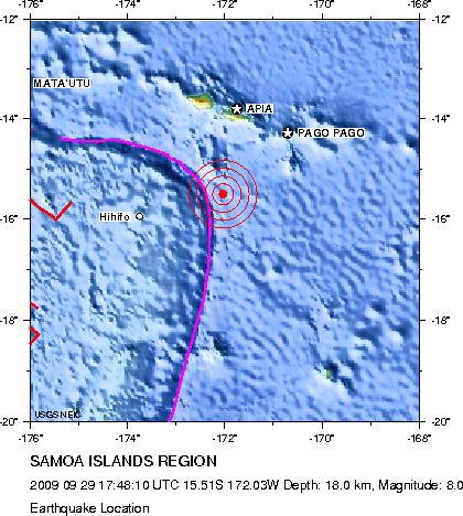
English: Earthquake location map. Major Tectonic Boundaries: Subduction Zones -purple, Ridges -red and Transform Faults -green
ไฟล, 2009, samoa, island, region, earthquake, location, ไฟล, ประว, ไฟล, หน, าท, ภาพน, การใช, ไฟล, วนกลาง, อม, ลเก, ยวก, บภาพไม, ภาพท, รายละเอ, ยดส, งกว, าน, 2009, samoa, island, region, earthquake, location, 8206, กเซล, ขนาดไฟล, โลไบต, ชน, ดไมม, image, jpeg, ป. ifl prawtiifl hnathimiphaphni karichiflswnklang khxmulekiywkbphaphimmiphaphthimiraylaexiydsungkwani 2009 09 29 Samoa Island Region earthquake location jpg 8206 420 468 phikesl khnadifl 57 kiolibt chnidimm image jpeg rupphaphhruxiflesiyngni tnchbbxyuthi khxmmxns raylaexiyddanlang epnkhxkhwamthiaesdngphlcak ifltnchbbinkhxmmxns khxmmxnsepnewbistinokhrngkarsahrbekbrwbrwmsuxesri thi khunsamarthchwyid This image was uploaded in the JPEG format even though it consists of non photographic data This information could be stored more efficiently or accurately in the PNG or SVG format If possible please upload a PNG or SVG version of this image without compression artifacts derived from a non JPEG source or with existing artifacts removed After doing so please tag the JPEG version with Superseded NewImage ext and remove this tag This tag should not be applied to photographs or scans For more information see BadJPEG khwamyx khaxthibay2009 09 29 Samoa Island Region earthquake location jpg English Earthquake location map Major Tectonic Boundaries Subduction Zones purple Ridges red and Transform Faults green Deutsch Erdbebenlagekarte wnthi 29 knyayn ph s 2552aehlngthima http neic usgs gov neis eq depot 2009 eq 090929 mdbi neic mdbi l htmlphusrangsrrkh United States Geological Survey karxnuyatichsiththi Public domain Public domain false falseThis image is in the public domain in the United States because it only contains materials that originally came from the United States Geological Survey an agency of the United States Department of the Interior For more information see the official USGS copyright policy Bahasa Indonesia catala cestina Deutsch eesti English espanol francais galego italiano Nederlands portugues polski sicilianu suomi Tiếng Việt Turkce blgarski makedonski russkij മലയ ള 한국어 日本語 中文 中文 简体 中文 繁體 العربية فارسی khabrryayodyyxithyephimkhabrryaythrrthdediywephuxkhyaykhwamwaiflnimixairixethmthiaesdngxyuiniflniprakxbdwywnthisrang wnkxtng29 knyayn 2009 prawtiifl khlikwnthi ewlaephuxduiflthipraktinkhnann wnthi ewlarupyxkhnadphuichkhwamehn pccubn22 05 1 tulakhm 2552420 468 57 kiolibt AvenueUpdated version from USGS website http neic usgs gov neis eq depot 2009 eq 090929 mdbi neic mdbi jpg Created by USGS so public domain 03 52 30 knyayn 2552420 468 57 kiolibt Matthiasb Information Description en 1 Earthquake location map Major Tectonic Boundaries Subduction Zones purple Ridges red and Transform Faults green de 1 Erdbebenlagekarte Source http neic usgs gov neis eq depot 2009 eq 090929 mdbi neic mdbi hnathimiphaphni hnatxipni oyngmathiphaphni aephndinihwinhmuekaasamw ph s 2552 karichiflswnklang wikixuntxipniichiflni karichbn de wikipedia org Erdbeben bei den Samoainseln 2009 karichbn de wikinews org Schweres Erdbeben in Samoa fuhrt zu Tsunami karichbn en wikinews org Death toll from tsunami in Southeast Asia increases karichbn es wikipedia org Terremoto de Samoa de 2009 Portal Samoa Portal Samoa Seleccionado karichbn es wikinews org Maremotos causan mas de 100 muertos en Samoa karichbn eu wikipedia org 2009ko Samoako lurrikara karichbn fi wikipedia org Samoan maanjaristys 2009 karichbn fr wikipedia org Seisme de 2009 aux Samoa Discussion Listes de seismes karichbn he wikipedia org פורטל גאולוגיה חדשות ארכיון 2009 karichbn hif wikipedia org Template Taaja khabar ke archive 2009 karichbn id wikipedia org Gempa bumi Samoa 2009 karichbn it wikipedia org Terremoto delle Samoa del 2009 karichbn ja wikipedia org サモア沖地震 2009年 karichbn ms wikipedia org Tsunami Samoa 2009 karichbn nl wikipedia org Aardbeving Samoa eilanden 2009 karichbn no wikipedia org Jordskjelvet og tsunamien ved Samoa 2009 karichbn pl wikipedia org Trzesienie ziemi na Wyspach Samoa 2009 karichbn pl wikinews org 2009 09 30 Kataklizmy tsunami na Pacyfiku i trzesienie ziemi w Indonezji Ketsana pustoszy Azje karichbn pt wikipedia org Portal Samoa Artigo selecionado 2 Portal Samoa Artigo selecionado karichbn pt wikinews org Tremor de terra provoca tsunami no Pacifico karichbn ro wikipedia org Cutremurul din Samoa 2009 karichbn www wikidata org Q921497 karichbn zh wikipedia org 2009年萨摩亚地震khxmulekiywkbphaph phaphnimikhxmulephimetim sungswnihymacakklxngdicitxlhruxsaeknenxrthisamarthekbkhxmuldngklawiwrwmkbphaphid thaphaphnithukprbprungaekikhhruxepliynaeplngcakedim khxmulbangxyangcayngkhngimepliynaeplngehmuxnphaphthithukprbprungaekikhnnkhwamehnifl JPEGHandmade Software Inc Image Alchemy v1 14 ekhathungcak https th wikipedia org wiki ifl 2009 09 29 Samoa Island Region earthquake location jpg, wikipedia, วิกิ หนังสือ, หนังสือ, ห้องสมุด,