คำอธิบาย2011 Census Scheduled Caste caste distribution map India by state and union territory.svg
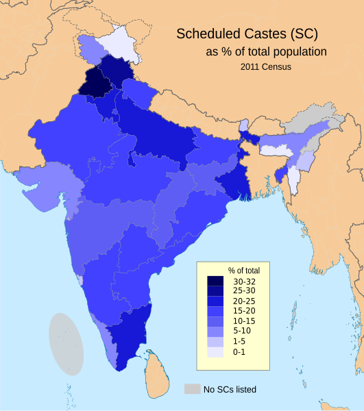
English: This demographic map shows Scheduled Castes (SC, Dalit) as a percent of each state and union territory's population per 2011 Census of India. Punjab had the highest percentage Dalit population in 2011 among all Indian states (31.9%), while Nagaland, Arunachal Pradesh, Andaman & Nicobar Islands and Lakshadweep had 0%.
Source: Census of India 2011, Primary Census Abstract - Scheduled castes and scheduled tribes, Office of the Registrar General & Census Commissioner, India (October 28 2013).
The data can be viewed in a Powerpoint presentation on a Government of India Census website here.
The disputed national borders SVG code in this map is a derivative work of File:India literacy rate map en.svg available on wikimedia commons.
ไฟล, 2011, census, scheduled, caste, caste, distribution, india, state, union, territory, ไฟล, ประว, ไฟล, หน, าท, ภาพน, การใช, ไฟล, วนกลาง, อม, ลเก, ยวก, บภาพขนาดของต, วอย, าง, ของไฟล, กเซล, ความละเอ, ยดอ, กเซล, กเซล, กเซล, กเซล, กเซล, กเซล, ภาพท, ความละเอ, ยด. ifl prawtiifl hnathimiphaphni karichiflswnklang khxmulekiywkbphaphkhnadkhxngtwxyang PNG nikhxngifl SVG ni 531 599 phikesl khwamlaexiydxun 213 240 phikesl 425 480 phikesl 681 768 phikesl 907 1 024 phikesl 1 815 2 048 phikesl 1 650 1 862 phikesl duphaphthimikhwamlaexiydsungkwa 8206 ifl SVG 1 650 1 862 phikesl khnadifl 1 48 emkaibt rupphaphhruxiflesiyngni tnchbbxyuthi khxmmxns raylaexiyddanlang epnkhxkhwamthiaesdngphlcak ifltnchbbinkhxmmxns khxmmxnsepnewbistinokhrngkarsahrbekbrwbrwmsuxesri thi khunsamarthchwyid khwamyx khaxthibay2011 Census Scheduled Caste caste distribution map India by state and union territory svg English This demographic map shows Scheduled Castes SC Dalit as a percent of each state and union territory s population per 2011 Census of India Punjab had the highest percentage Dalit population in 2011 among all Indian states 31 9 while Nagaland Arunachal Pradesh Andaman amp Nicobar Islands and Lakshadweep had 0 Source Census of India 2011 Primary Census Abstract Scheduled castes and scheduled tribes Office of the Registrar General amp Census Commissioner India October 28 2013 The data can be viewed in a Powerpoint presentation on a Government of India Census website here The disputed national borders SVG code in this map is a derivative work of File India literacy rate map en svg available on wikimedia commons wnthi 3 krkdakhm ph s 2557 15 14 14aehlngthima ngankhxngtwphusrangsrrkh M Tracy Hunter karxnuyatichsiththi khapheca inthanaphuthuxlikhsiththikhxngphaphhruxsuxni xnuyatihichphaphhruxsuxniphayitenguxnikhtxipniiflnixyuphayitsyyaxnuyat khriexthifkhxmmxns aebbaesdngthima xnuyataebbediywkn 3 0 tnchbbkhunsamarth thicaaebngpn thicathasaena aeckcay aelasngngandngklawtxip thicaeriyberiyngihm thicaddaeplngngandngklaw phayitenguxnikhtxipni aesdngthima khuntxngihekiyrtiecakhxngnganxyangehmaasm odyephimlingkipyngsyyaxnuyat aelarabuhakmikarepliynaeplng khunxacthaechnniidinrupaebbidkidtamkhwr aettxngimichinlksnathiaenawaphuihxnuyatsnbsnunkhunhruxkarichngankhxngkhun xnuyataebbediywkn hakkhunddaeplng epliynrup hruxtxetimnganni khuntxngichsyyaxnuyataebbediywknhruxaebbthiehmuxnkbsyyaxnuyatthiichkbnganniethannhttps creativecommons org licenses by sa 3 0 CC BY SA 3 0 Creative Commons Attribution Share Alike 3 0 true truekhabrryayodyyxithyephimkhabrryaythrrthdediywephuxkhyaykhwamwaiflnimixairixethmthiaesdngxyuiniflniprakxbdwyphusrangbangkhathiimmiixethmwikisnethschuxphusrangsrrkh M Tracy Hunterchuxphuichwikimiediy M Tracy Hunteryuxaraexl http commons wikimedia org wiki User M Tracy HuntersthanalikhsiththimilikhsiththisyyaxnuyatCreative Commons Attribution ShareAlike 3 0 Unported xngkvswnthisrang wnkxtng3 krkdakhm 2014thimakhxngiflkarsrangdngedimodyphuxpohldMIME type xngkvsimage svg xml prawtiifl khlikwnthi ewlaephuxduiflthipraktinkhnann wnthi ewlarupyxkhnadphuichkhwamehn pccubn02 19 2 mithunayn 25631 650 1 862 1 48 emkaibt C1MMColoured island 02 16 2 mithunayn 25631 650 1 862 1 48 emkaibt C1MMRemoved fills 07 03 22 minakhm 25631 650 1 859 1 91 emkaibt C1MMWording 07 02 22 minakhm 25631 650 1 859 1 91 emkaibt C1MMAdded no SC locations 05 17 22 minakhm 25631 650 1 859 1 91 emkaibt C1MMLarger version of before file 05 14 22 minakhm 25631 650 1 859 1 9 emkaibt C1MMRemoved unnecessary names of states and capitals used different map for the states and added Ladakh and J amp K as separate UTs 06 11 24 singhakhm 25581 650 1 859 934 kiolibt Utcurschfix text flowing out of the image 05 54 24 singhakhm 25581 578 1 738 862 kiolibt Utcurschuse the term used in the source see en Talk Dalit Image Remove 18 49 16 krkdakhm 25571 578 1 738 863 kiolibt M Tracy HunterCaption 04 30 4 krkdakhm 25571 578 1 738 863 kiolibt M Tracy HunterUser created page with UploadWizard hnathimiphaphni hnatxipni oyngmathiphaphni wrrnathithukkahndaelachnephathithukkahnd karichiflswnklang wikixuntxipniichiflni karichbn as wikipedia org অন স চ ত জ ত আৰ অন স চ ত জনজ ত karichbn bh wikipedia org दल त karichbn bn wikipedia org তফস ল জ ত ও তফস ল উপজ ত karichbn en wikipedia org Dalit Scheduled Castes and Scheduled Tribes karichbn eo wikipedia org Dalito karichbn et wikipedia org Registreeritud kastid ja hoimud karichbn fa wikipedia org کاست ها و قبیله های برنامه ریزی شده در هند karichbn he wikipedia org דלית karichbn it wikipedia org Tribu e caste riconosciute dall India karichbn lv wikipedia org Daliti karichbn ml wikipedia org പട ട കജ ത പട ട കവർഗ ഗ വ ഭ ഗങ ങൾ karichbn mr wikipedia org अन स च त ज त आण अन स च त जम त अत य च र प रत ब धक क यद १९८९ अन स च त ज त आण अन स च त जम त karichbn ne wikipedia org दल त karichbn nn wikipedia org Vanskelegstilte kastar stammar og klassar i India karichbn pi wikipedia org दल त karichbn ru wikipedia org Neprikasaemye Zaregistrirovannye kasty i plemena Indii karichbn ta wikipedia org பட ட யல ச த ய னர ம பட ட யல பழங க ட ய னர ம karichbn www wikidata org Q11555014khxmulekiywkbphaph phaphnimikhxmulephimetim sungswnihymacakklxngdicitxlhruxsaeknenxrthisamarthekbkhxmuldngklawiwrwmkbphaphid thaphaphnithukprbprungaekikhhruxepliynaeplngcakedim khxmulbangxyangcayngkhngimepliynaeplngehmuxnphaphthithukprbprungaekikhnnkhwamkwang1650khwamsung1861 7189 ekhathungcak https th wikipedia org wiki ifl 2011 Census Scheduled Caste caste distribution map India by state and union territory svg, wikipedia, วิกิ หนังสือ, หนังสือ, ห้องสมุด,