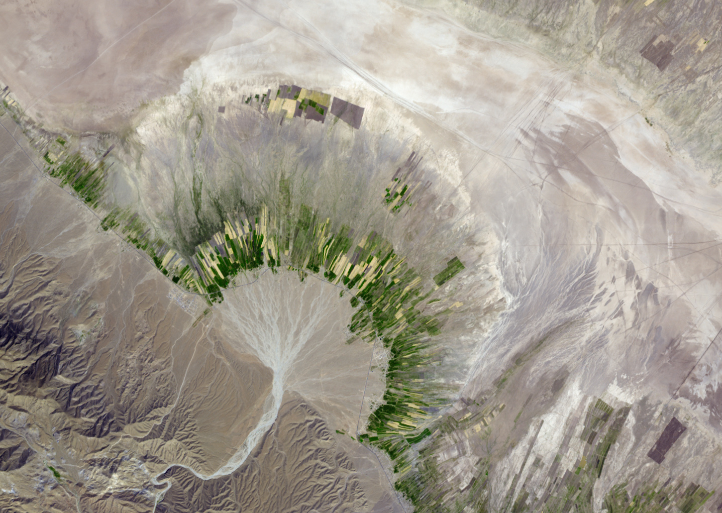
English: Seasonally dry salt lakes and the traces of ephemeral streams occupy many of the valleys of the Zagros Mountains in southern Iran. Much of the time, the rivers and lakes are dry above ground, but subterranean water flows along the same pathways. Where these subterranean streams flow out of the mountains, the water table comes closer to the surface, and it is more readily accessible through wells. This simulated natural-color image of southeastern Fars province in southern Iran shows a dry river channel carving through arid mountains toward the northeast. The dry river spreads out across the valley floor in a silvery fan. A broad belt of lush agricultural land follows the curve of the fan and stretches out along a road that runs parallel to the ridgeline. The valley-ward margin of the intensely green agricultural belt fades to dull green along streams (or irrigation canals). The image was captured by the Advanced Spaceborne Thermal Emission and Reflection Radiometer (ASTER) on NASA’s Terra satellite on October 12, 2004.
NASA image created by Jesse Allen, using data from NASA/GSFC/METI/ERSDAC/JAROS, and the U.S./Japan ASTER Science Team. Caption by Rebecca Lindsey, based on interpretation provided on the ASTER Project Science Imagery Gallery Website.
{{BotMoveToCommons|en.wikipedia|year={{subst:CURRENTYEAR}}|month={{subst:CURRENTMONTHNAME}}|day={{subst:CURRENTDAY}}}} {{Information |Description={{en|Alluvial Fan in Southern Iran NASA image created by Jesse Allen, using data from NASA/GSFC/METI/ERSDAC
ไฟล, alluvial, iran, ไฟล, ประว, ไฟล, หน, าท, ภาพน, การใช, ไฟล, วนกลาง, อม, ลเก, ยวก, บภาพขนาดของต, วอย, างน, กเซล, ความละเอ, ยดอ, กเซล, กเซล, กเซล, กเซล, กเซล, ภาพท, ความละเอ, ยดส, งกว, 8206, กเซล, ขนาดไฟล, โลไบต, ชน, ดไมม, image, jpeg, ปภาพหร, อไฟล, เส, ยงน, . ifl prawtiifl hnathimiphaphni karichiflswnklang khxmulekiywkbphaphkhnadkhxngtwxyangni 800 568 phikesl khwamlaexiydxun 320 227 phikesl 640 455 phikesl 1 024 728 phikesl 1 280 909 phikesl 1 451 1 031 phikesl duphaphthimikhwamlaexiydsungkwa 8206 1 451 1 031 phikesl khnadifl 704 kiolibt chnidimm image jpeg rupphaphhruxiflesiyngni tnchbbxyuthi khxmmxns raylaexiyddanlang epnkhxkhwamthiaesdngphlcak ifltnchbbinkhxmmxns khxmmxnsepnewbistinokhrngkarsahrbekbrwbrwmsuxesri thi khunsamarthchwyid khwamyx khaxthibayAlluvial fan in Iran jpg English Seasonally dry salt lakes and the traces of ephemeral streams occupy many of the valleys of the Zagros Mountains in southern Iran Much of the time the rivers and lakes are dry above ground but subterranean water flows along the same pathways Where these subterranean streams flow out of the mountains the water table comes closer to the surface and it is more readily accessible through wells This simulated natural color image of southeastern Fars province in southern Iran shows a dry river channel carving through arid mountains toward the northeast The dry river spreads out across the valley floor in a silvery fan A broad belt of lush agricultural land follows the curve of the fan and stretches out along a road that runs parallel to the ridgeline The valley ward margin of the intensely green agricultural belt fades to dull green along streams or irrigation canals The image was captured by the Advanced Spaceborne Thermal Emission and Reflection Radiometer ASTER on NASA s Terra satellite on October 12 2004 wnthi 12 tulakhm ph s 2547aehlngthima http earthobservatory nasa gov IOTD view php id 36041phusrangsrrkh NASA image created by Jesse Allen using data from NASA GSFC METI ERSDAC JAROS and the U S Japan ASTER Science Team Caption by Rebecca Lindsey based on interpretation provided on the ASTER Project Science Imagery Gallery Website karxnuyatichsiththi Public domain Public domain false falsephaphniepnsatharnsmbti enuxngcakepnphaphthisrangkhunodyxngkhkarbriharkarbinaelaxwkasaehngchati NASA sungtamnoybaydanlikhsiththikhxngnasarabuiwwa phaphaelasuxtang khxngnasaimidrbkarkhumkhrxngodylikhsiththiykewncarabuiwwamilikhsiththi duephimthi hnanoybaydanlikhsiththikhxngnasa hrux noybaykarichphaphkhxng JPLkhaetuxn karich olokkhxngnasa ekhruxnghmayaelaekhruxngpradbkhxngnasa thukcakddwykdhmayshrthxemrikainlksna 14 khxngkhxbngkhbthangrachkarshrthxemrika swnthi 1221 ewbistkhxngnasaekbrwbrwmphaphthimacakxngkhkarxwkasosewiyt xngkhkarxwkasaehngchatirsesiy aelaxngkhkarxwkasthimiichxngkhkarxwkaskhxngshrthxemrika epncanwnmak phaphehlaniimcaepntxngepnsatharnsmbtiesmxip phaphhruxsuxthimacak klxngothrthrrsnxwkashbebil xacmilikhsiththi hakphaphhruxsuxnnimidrabuchdecnwamacak sthabnwithyasastrklxngothrthrrsnxwkas 1 phaphhruxsuxthnghmdthimacakekhruxngmuxkhxng okhrngkarsuksadwngxathityaelalmsuriya milikhsiththi karnaphaphhruxsuxcakokhrngkaripichnxkehnuxcakkarichephuxkarkhahruxephuxkarsuksa txngidrbxnuyatkxn 2 phaphthithukkhdeluxkihepn phaphdarasastrpracawn APOD bnewbistkhxng APOD xacmilikhsiththi 3 khabrryayodyyxithyephimkhabrryaythrrthdediywephuxkhyaykhwamwaiflnimixairxngkvsAlluvial Fan in Southern Iran Image from NASA s Terra satelliteixethmthiaesdngxyuiniflniprakxbdwywnthisrang wnkxtng12 tulakhm 2004 prawtiifl khlikwnthi ewlaephuxduiflthipraktinkhnann wnthi ewlarupyxkhnadphuichkhwamehn pccubn02 38 3 thnwakhm 25611 451 1 031 704 kiolibt AriadacapoCropped 52 horizontally 57 vertically using CropTool with lossless mode 02 36 3 thnwakhm 25613 000 2 400 3 22 emkaibt AriadacapoFull size original from source 07 27 17 kumphaphnth 2553720 480 300 kiolibt File Upload Bot Magnus Manske BotMoveToCommons en wikipedia year subst CURRENTYEAR month subst CURRENTMONTHNAME day subst CURRENTDAY Information Description en Alluvial Fan in Southern Iran NASA image created by Jesse Allen using data from NASA GSFC METI ERSDAC hnathimiphaphni hnatxipni oyngmathiphaphni takxnnapharupphd karichiflswnklang wikixuntxipniichiflni karichbn bs wikipedia org Geografija Irana karichbn ca wikipedia org Qanat karichbn en wikipedia org Qanat karichbn en wikibooks org High School Earth Science Water Erosion and Deposition karichbn fa wikipedia org قنات تصویربرداری ماهواره ای فهرست میراث جهانی در پاکستان karichbn gl wikipedia org Abano aluvial karichbn he wikipedia org פוגארה karichbn hr wikipedia org Zemljopis Irana karichbn hu wikipedia org Hordalekkup Qanat karichbn it wikibooks org Scienze della Terra per le superiori Il modellamento fluviale karichbn it wikiversity org Il modellamento fluviale superiori karichbn nl wikipedia org Qanat Waterbeheer in puinwaaiers karichbn ru wikipedia org Kyariz karichbn sh wikipedia org Geografija Irana Aluvijalna lepeza karichbn simple wikipedia org Alluvial fan karichbn sl wikipedia org Kanat Aluvialni stozec karichbn sr wikipedia org Aluvijalna lepeza karichbn ta wikipedia org பயனர Tnse rabeek diet tut மணல த ட ட வண டல வ ச ற karichbn tr wikipedia org Aluvyon yelpazesikhxmulekiywkbphaph phaphnimikhxmulephimetim sungswnihymacakklxngdicitxlhruxsaeknenxrthisamarthekbkhxmuldngklawiwrwmkbphaphid thaphaphnithukprbprungaekikhhruxepliynaeplngcakedim khxmulbangxyangcayngkhngimepliynaeplngehmuxnphaphthithukprbprungaekikhnnchuxphaphIDL TIFF filekhwamkwang5 661 phikeslkhwamsung5 035 phikeslbittxkhxmophennt8 8 8rupaebbkarbibxdLZWphikeslkhxmophsichnRGBkarcdwangphaphpkticanwnkhxmophennt3khwamlaexiydaenwnxn100 dpikhwamlaexiydaenwtng100 dpikarcderiyngkhxmulrupaebbchngkisxftaewrthiichAdobe Photoshop CS3 Macintoshaekikhphaphlasud12 33 1 thnwakhm 2551sepssiimidprbethiybkhwamkwangkhxngphaph3 000 phikeslkhwamsungkhxngphaph2 400 phikeslewlathiaeplngepndicithl07 33 1 thnwakhm 2551wnthiaekikhkhxmulemtalasud07 33 1 thnwakhm 2551 ekhathungcak https th wikipedia org wiki ifl Alluvial fan in Iran jpg, wikipedia, วิกิ หนังสือ, หนังสือ, ห้องสมุด,