This file is a map of a municipality in Japan created and uploaded by Lincun on Japanese Wikipedia. It may also be a file based on one of these maps (see info in file history or author field for more info on later editors). Source:
English: Data used : Ministry of Land, Infrastructure, Transport and Tourism - National Land Numerical Information (Administrative Area (N03) / Lake (W09))
日本語: 使用データ : 国土交通省 国土数値情報(行政区域(N03)・湖沼(W09))
The original file was licensed {{GFDL}} and {{Cc-by-sa-3.0}}. See this category for more files like this. ป้ายนี้มิใช่ป้ายแสดงสถานะลิขสิทธิ์ ดังนั้นการระบุสถานะลิขสิทธิ์จึงต้องกระทำแยกต่างหาก ดูที่ Commons:Lincensing
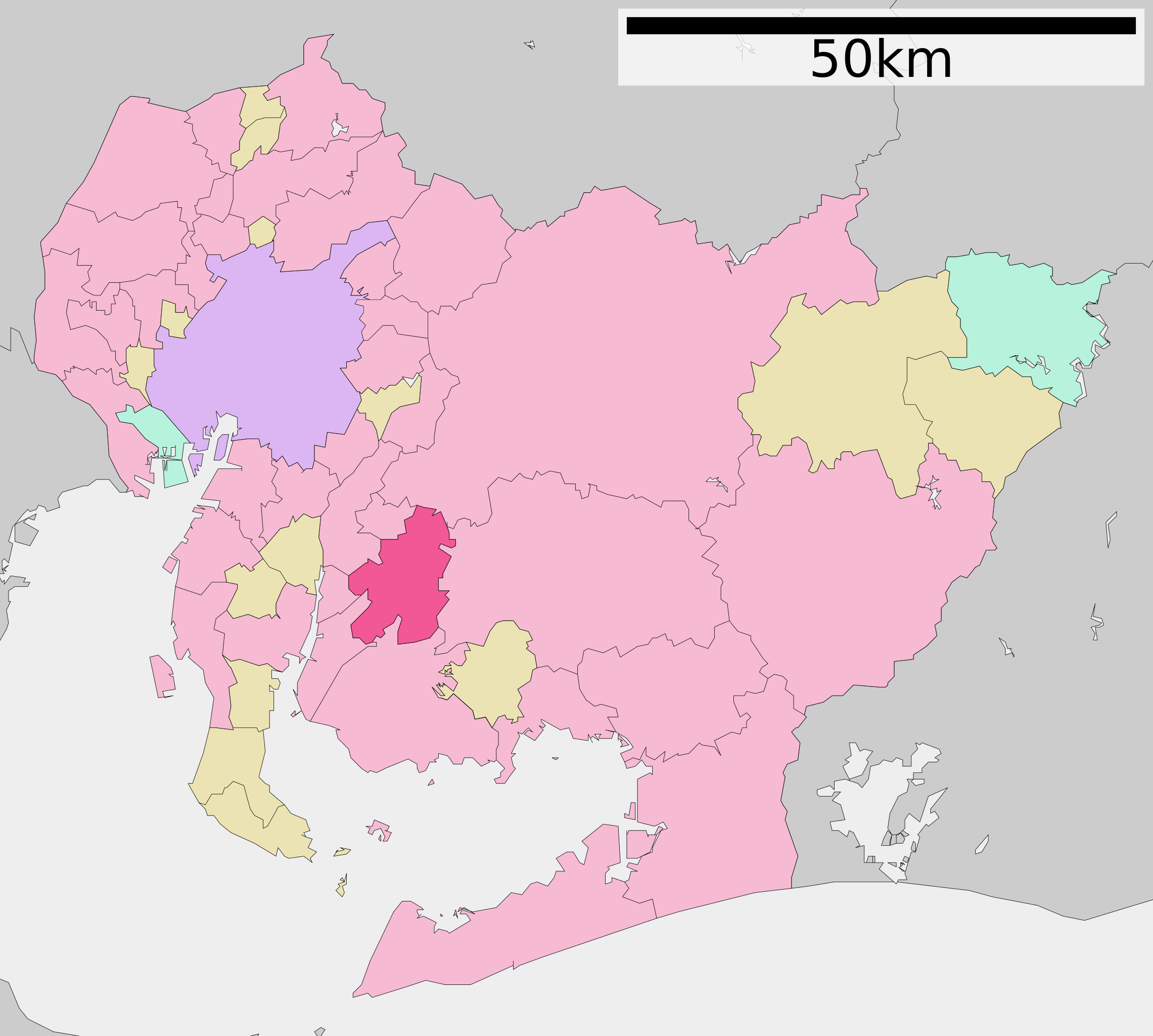
{{Information |Description=Anjo in Aichi Prefecture |Source=Transferred from [http://ja.wikipedia.org ja.wikipedia]; transferred to Commons by DanGarb. |Date=2008-01-15 (original upload date) |Author=Original uploader was [[:ja:User:Lincu
ไฟล, anjo, aichi, prefecture, ไฟล, ประว, ไฟล, หน, าท, ภาพน, การใช, ไฟล, วนกลาง, อม, ลเก, ยวก, บภาพขนาดของต, วอย, าง, ของไฟล, กเซล, ความละเอ, ยดอ, กเซล, กเซล, กเซล, กเซล, กเซล, ภาพท, ความละเอ, ยดส, งกว, 8206, ไฟล, กเซล, ขนาดไฟล, โลไบต, ปภาพหร, อไฟล, เส, ยงน, นฉ. ifl prawtiifl hnathimiphaphni karichiflswnklang khxmulekiywkbphaphkhnadkhxngtwxyang PNG nikhxngifl SVG ni 539 484 phikesl khwamlaexiydxun 267 240 phikesl 535 480 phikesl 855 768 phikesl 1 140 1 024 phikesl 2 281 2 048 phikesl duphaphthimikhwamlaexiydsungkwa 8206 ifl SVG 539 484 phikesl khnadifl 24 kiolibt rupphaphhruxiflesiyngni tnchbbxyuthi khxmmxns raylaexiyddanlang epnkhxkhwamthiaesdngphlcak ifltnchbbinkhxmmxns khxmmxnsepnewbistinokhrngkarsahrbekbrwbrwmsuxesri thi khunsamarthchwyid khwamyx khaxthibayAnjo in Aichi Prefecture Ja svg English Anjo in Aichi Prefecture 日本語 ja 愛知県安城市位置図wnthi 更新 2010年3月22日aehlngthima Original file ngankhxngtw Data 国土交通省 国土数値情報 行政区域 N03 湖沼 W09 phusrangsrrkh Lincunkarxnuyat karichiflniihm This file is a map of a municipality in Japan created and uploaded by Lincun on Japanese Wikipedia It may also be a file based on one of these maps see info in file history or author field for more info on later editors Source English Data used Ministry of Land Infrastructure Transport and Tourism National Land Numerical Information Administrative Area N03 Lake W09 日本語 使用データ 国土交通省 国土数値情報 行政区域 N03 湖沼 W09 The original file was licensed GFDL and Cc by sa 3 0 See this category for more files like this paynimiichpayaesdngsthanalikhsiththi dngnnkarrabusthanalikhsiththicungtxngkrathaaeyktanghak duthi Commons Lincensing karxnuyatichsiththi xnuyatihkhdlxk aeckcayaela hruxddaeprexksarniphayitenguxnikhkhxngsyyaxnuyatexksaresrikhxngknu run 1 2 hruxrunid nbcaknithixxkodymulnithisxftaewresri odyimmiswnidhamaekikh immikhxkhwampkhnaaelapkhlng saenakhxngsyyaxnuyatrwmxyuinswnchux syyaxnuyatexksaresrikhxngknuhttp www gnu org copyleft fdl html GFDL GNU Free Documentation License true trueiflnixyuphayitsyyaxnuyat khriexthifkhxmmxns aebbaesdngthima xnuyataebbediywkn 3 0 tnchbbkhunsamarth thicaaebngpn thicathasaena aeckcay aelasngngandngklawtxip thicaeriyberiyngihm thicaddaeplngngandngklaw phayitenguxnikhtxipni aesdngthima khuntxngihekiyrtiecakhxngnganxyangehmaasm odyephimlingkipyngsyyaxnuyat aelarabuhakmikarepliynaeplng khunxacthaechnniidinrupaebbidkidtamkhwr aettxngimichinlksnathiaenawaphuihxnuyatsnbsnunkhunhruxkarichngankhxngkhun xnuyataebbediywkn hakkhunddaeplng epliynrup hruxtxetimnganni khuntxngichsyyaxnuyataebbediywknhruxaebbthiehmuxnkbsyyaxnuyatthiichkbnganniethannhttps creativecommons org licenses by sa 3 0 CC BY SA 3 0 Creative Commons Attribution Share Alike 3 0 true true bnthukkarxphohld This file was moved from Japanese Wikipedia See below for original file information File name 基礎自治体位置図 23212 svgDescription 基礎自治体位置図画像情報 愛知県 安城市 20100322 File history wnthi ewla UTC khnad phuich khwamehn28 knyayn ph s 2550 15 09 39 660x672 Lincun 基礎自治体位置図画像情報 愛知県 安城市 15 mkrakhm ph s 2551 14 19 28 660x672 Lincun 基礎自治体位置図画像情報 愛知県 安城市 24 phvscikayn ph s 2552 13 42 56 539x484 Lincun 基礎自治体位置図画像情報 愛知県 安城市 20091001 13 kumphaphnth ph s 2553 00 39 29 539x484 Lincun 基礎自治体位置図画像情報 愛知県 安城市 20100104 22 minakhm ph s 2553 13 56 09 539x484 Lincun 基礎自治体位置図画像情報 愛知県 安城市 20100322 Page history wnthi ewla UTC Flag phuich khwamyx 28 knyayn ph s 2550 15 09 39 Lincun 基礎自治体位置図画像情報 愛知県 安城市 15 mkrakhm ph s 2551 14 19 28 Lincun 画像 基礎自治体位置図 23212 svg の新しい版をアップロードしました 基礎自治体位置図画像情報 愛知県 安城市 3 phvscikayn ph s 2552 06 46 26 Monaneko24 phvscikayn ph s 2552 13 42 56 Lincun ファイル 基礎自治体位置図 23212 svg の新しい版をアップロードしました 基礎自治体位置図画像情報 愛知県 安城市 20091001 24 phvscikayn ph s 2552 14 35 01 Lincun 2009100113 kumphaphnth ph s 2553 00 39 29 Lincun ファイル 基礎自治体位置図 23212 svg の新しい版をアップロードしました 基礎自治体位置図画像情報 愛知県 安城市 20100104 13 kumphaphnth ph s 2553 00 39 54 Lincun22 minakhm ph s 2553 13 56 09 Lincun ファイル 基礎自治体位置図 23212 svg の新しい版をアップロードしました 基礎自治体位置図画像情報 愛知県 安城市 20100322 22 minakhm ph s 2553 13 56 32 LincunDeutsch English makedonski 한국어 日本語 فارسی khabrryayodyyxithyephimkhabrryaythrrthdediywephuxkhyaykhwamwaiflnimixairixethmthiaesdngxyuiniflniprakxbdwysthanalikhsiththimilikhsiththisyyaxnuyatGNU Free Documentation License version 1 2 or later xngkvsCreative Commons Attribution ShareAlike 3 0 Unported xngkvs prawtiifl khlikwnthi ewlaephuxduiflthipraktinkhnann wnthi ewlarupyxkhnadphuichkhwamehn pccubn11 04 22 singhakhm 2563539 484 24 kiolibt AichiWikiFixerUpdated from File Map of Aichi Prefecture Ja svg 01 58 20 phvscikayn 2558539 484 13 kiolibt VulpesVulpes42Updated from https ja wikipedia org wiki 基礎自治体位置図 23212 svg 20 56 22 minakhm 2553539 484 13 kiolibt Lincun 基礎自治体位置図画像情報 愛知県 安城市 20100322 07 39 13 kumphaphnth 2553539 484 14 kiolibt Lincun 基礎自治体位置図画像情報 愛知県 安城市 20100104 05 12 8 mkrakhm 2553539 484 10 kiolibt Krisgrotius update Date 1 October 2009 Author ja 利用者 Lincun 20 42 24 phvscikayn 2552539 484 10 kiolibt Lincun 基礎自治体位置図画像情報 愛知県 安城市 20091001 14 26 30 singhakhm 2551660 672 22 kiolibt DanGarb Information Description Anjo in Aichi Prefecture Source Transferred from http ja wikipedia org ja wikipedia transferred to Commons by DanGarb Date 2008 01 15 original upload date Author Original uploader was ja User Lincu 21 19 15 mkrakhm 2551660 672 22 kiolibt Lincun 基礎自治体位置図画像情報 愛知県 安城市 22 09 28 knyayn 2550660 672 22 kiolibt Lincun 基礎自治体位置図画像情報 愛知県 安城市 hnathimiphaphni hnatxipni oyngmathiphaphni xnoc karichiflswnklang wikixuntxipniichiflni karichbn ar wikipedia org أنجو آيتشي karichbn azb wikipedia org آنجو آیچی karichbn ca wikipedia org Anjō karichbn ce wikipedia org Andzyo karichbn de wikipedia org Anjō karichbn en wikipedia org Anjō karichbn en wiktionary org 安城 karichbn et wikipedia org Anjō karichbn fi wikipedia org Anjō karichbn gl wikipedia org Anjō karichbn hu wikipedia org Andzso karichbn id wikipedia org Anjō Aichi karichbn it wikipedia org Anjō karichbn ja wikipedia org 安城市 karichbn ko wikipedia org 안조시 karichbn nl wikipedia org Anjo karichbn ro wikipedia org Anjō karichbn sr wikipedia org Anџo karichbn sv wikipedia org Anjo Japan karichbn tl wikipedia org Anjō karichbn tt wikipedia org Andzyo karichbn uk wikipedia org Andzo karichbn ur wikipedia org آنجو ایچی karichbn vi wikipedia org Anjō karichbn www wikidata org Q270806 karichbn zh min nan wikipedia org Anzyo chhikhxmulekiywkbphaph phaphnimikhxmulephimetim sungswnihymacakklxngdicitxlhruxsaeknenxrthisamarthekbkhxmuldngklawiwrwmkbphaphid thaphaphnithukprbprungaekikhhruxepliynaeplngcakedim khxmulbangxyangcayngkhngimepliynaeplngehmuxnphaphthithukprbprungaekikhnnchuxeruxngsn愛知県行政区画地図 2010年3月22日 chuxphaphAuthor Lincunkhwamkwang539khwamsung484 ekhathungcak https th wikipedia org wiki ifl Anjo in Aichi Prefecture Ja svg, wikipedia, วิกิ หนังสือ, หนังสือ, ห้องสมุด,