العربية ∙ جازايرية ∙ беларуская ∙ беларуская (тарашкевіца) ∙ български ∙ বাংলা ∙ català ∙ čeština ∙ Cymraeg ∙ Deutsch ∙ Schweizer Hochdeutsch ∙ Zazaki ∙ Ελληνικά ∙ English ∙ Esperanto ∙ español ∙ eesti ∙ euskara ∙ فارسی ∙ suomi ∙ français ∙ galego ∙ עברית ∙ हिन्दी ∙ hrvatski ∙ magyar ∙ հայերեն ∙ Bahasa Indonesia ∙ italiano ∙ 日本語 ∙ Jawa ∙ ქართული ∙ 한국어 ∙ kurdî ∙ Lëtzebuergesch ∙ lietuvių ∙ македонски ∙ മലയാളം ∙ मराठी ∙ Bahasa Melayu ∙ Nederlands ∙ Norfuk / Pitkern ∙ polski ∙ português ∙ português do Brasil ∙ rumantsch ∙ română ∙ русский ∙ sicilianu ∙ slovenčina ∙ slovenščina ∙ shqip ∙ српски / srpski ∙ svenska ∙ தமிழ் ∙ తెలుగు ∙ ไทย ∙ Tagalog ∙ Türkçe ∙ українська ∙ vèneto ∙ Tiếng Việt ∙ 中文 ∙ 中文(简体) ∙ 中文(繁體) ∙ +/−
ภาพนี้ ได้รับการปรับแต่งภาพ ซึ่งหมายความว่าจะได้รับการเปลี่ยนแปลงภาพต่างจากต้นฉบับ การปรับปรุง: translated. ต้นฉบับสามารถดูได้ที่นี่: Aquifer.svg. ปรับแต่งภาพโดย Sebastian Wallroth.
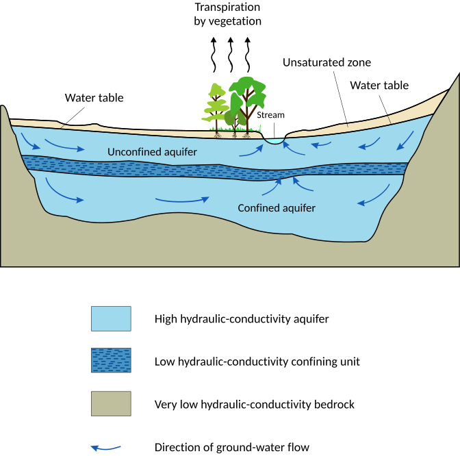
An aquifer cross-section. This diagram shows two aquifers with one aquitard (a confining or impermeable layer) between them, surrounded by the bedrock aquiclude, which is in contact with a gaining stream (typical in humid regions).
ไฟล, aquifer, ไฟล, ประว, ไฟล, หน, าท, ภาพน, การใช, ไฟล, วนกลาง, อม, ลเก, ยวก, บภาพขนาดของต, วอย, าง, ของไฟล, กเซล, ความละเอ, ยดอ, กเซล, กเซล, กเซล, กเซล, กเซล, กเซล, ภาพท, ความละเอ, ยดส, งกว, 8206, ไฟล, กเซล, ขนาดไฟล, โลไบต, ปภาพหร, อไฟล, เส, ยงน, นฉบ, บอย, คอ. ifl prawtiifl hnathimiphaphni karichiflswnklang khxmulekiywkbphaphkhnadkhxngtwxyang PNG nikhxngifl SVG ni 606 600 phikesl khwamlaexiydxun 243 240 phikesl 485 480 phikesl 776 768 phikesl 1 035 1 024 phikesl 2 070 2 048 phikesl 672 665 phikesl duphaphthimikhwamlaexiydsungkwa 8206 ifl SVG 672 665 phikesl khnadifl 35 kiolibt rupphaphhruxiflesiyngni tnchbbxyuthi khxmmxns raylaexiyddanlang epnkhxkhwamthiaesdngphlcak ifltnchbbinkhxmmxns khxmmxnsepnewbistinokhrngkarsahrbekbrwbrwmsuxesri thi khunsamarthchwyid khaxthibayAquifer en svg English Aquifer vectorized wnthi 25 phvsphakhm ph s 2550aehlngthima en Image Schematic aquifer xsection usgs cir1186 pngphusrangsrrkh Hans Hillewaertkarxnuyat karichiflniihm khapheca inthanaphuthuxlikhsiththikhxngphaphhruxsuxni xnuyatihichphaphhruxsuxniphayitenguxnikhtxipniiflnixyuphayitsyyaxnuyat khriexthifkhxmmxns aebbaesdngthima xnuyataebbediywkn 3 0 tnchbbkhunsamarth thicaaebngpn thicathasaena aeckcay aelasngngandngklawtxip thicaeriyberiyngihm thicaddaeplngngandngklaw phayitenguxnikhtxipni aesdngthima khuntxngihekiyrtiecakhxngnganxyangehmaasm odyephimlingkipyngsyyaxnuyat aelarabuhakmikarepliynaeplng khunxacthaechnniidinrupaebbidkidtamkhwr aettxngimichinlksnathiaenawaphuihxnuyatsnbsnunkhunhruxkarichngankhxngkhun xnuyataebbediywkn hakkhunddaeplng epliynrup hruxtxetimnganni khuntxngichsyyaxnuyataebbediywknhruxaebbthiehmuxnkbsyyaxnuyatthiichkbnganniethannhttps creativecommons org licenses by sa 3 0 CC BY SA 3 0 Creative Commons Attribution Share Alike 3 0 true true Public domain Public domain false falseThis image is in the public domain in the United States because it only contains materials that originally came from the United States Geological Survey an agency of the United States Department of the Interior For more information see the official USGS copyright policy Bahasa Indonesia catala cestina Deutsch eesti English espanol francais galego italiano Nederlands portugues polski sicilianu suomi Tiếng Việt Turkce blgarski makedonski russkij മലയ ള 한국어 日本語 中文 中文 简体 中文 繁體 العربية فارسی ewxrchnxun aekikh Deutsch Dine bizaad English English PNG original espanol euskara galego italiano Nederlands polski romană Turkce ukrayinska न प ल অসম য ব ল ਪ ਜ ਬ ગ જર ત தம ழ త ల గ ಕನ ನಡ العربيةOther licensesInfoFieldMore 4100 and new images on High resolution files on request karaesdngthima caepntxngmitamsyyaxnuyat InfoField c Hans Hillewaert CC BY SA 4 0InfoField c Hans HillewaertSVG genesisInfoField sxrsokhdkhxng SVG nitrwcsxbthuktxngaelw iflphaphkrafiksewketxrni srangkhunodyich Adobe Illustrator This diagram uses embedded text that can be easily translated using a text editor phaphkhunphaph phaphniepnphaphkhunphaphtamhlkeknthkarphicarnaphaphkhunphaph العربية جازايرية belaruskaya belaruskaya tarashkevica blgarski ব ল catala cestina Cymraeg Deutsch Schweizer Hochdeutsch Zazaki Ellhnika English Esperanto espanol eesti euskara فارسی suomi francais galego עברית ह न द hrvatski magyar հայերեն Bahasa Indonesia italiano 日本語 Jawa ქართული 한국어 kurdi Letzebuergesch lietuviu makedonski മലയ ള मर ठ Bahasa Melayu Nederlands Norfuk Pitkern polski portugues portugues do Brasil rumantsch romană russkij sicilianu slovencina slovenscina shqip srpski srpski svenska தம ழ త ల గ ithy Tagalog Turkce ukrayinska veneto Tiếng Việt 中文 中文 简体 中文 繁體 phaphni idrbkarprbaetngphaph sunghmaykhwamwacaidrbkarepliynaeplngphaphtangcaktnchbb karprbprung translated tnchbbsamarthduidthini Aquifer svg prbaetngphaphody Sebastian Wallroth khabrryayodyyxithyephimkhabrryaythrrthdediywephuxkhyaykhwamwaiflnimixairxngkvsAn aquifer cross section This diagram shows two aquifers with one aquitard a confining or impermeable layer between them surrounded by the bedrock aquiclude which is in contact with a gaining stream typical in humid regions ixethmthiaesdngxyuiniflniprakxbdwyphusrangbangkhathiimmiixethmwikisnethschuxphuichwikimiediy Biopicshnathikhxngwtthuphayitpraphcnni changphaphyuxaraexl https commons wikimedia org wiki user Biopicschuxphusrangsrrkh Hans HillewaertsthanalikhsiththimilikhsiththisyyaxnuyatCreative Commons Attribution ShareAlike 3 0 Unported xngkvswnthisrang wnkxtng25 phvsphakhm 2007Commons quality assessment xngkvsWikimedia Commons quality image xngkvs prawtiifl khlikwnthi ewlaephuxduiflthipraktinkhnann wnthi ewlarupyxkhnadphuichkhwamehn pccubn05 19 28 emsayn 2555672 665 35 kiolibt Fred the OysterOptimise code 14 59 25 phvsphakhm 2550720 700 83 kiolibt Lycaon Summary Information Description en Aquifer vectorized Source en Image Schematic aquifer xsection usgs cir1186 png Date 22 06 2006 Author Hans Hillewaert Lycaon Permission self cc by sa 2 5 PD USGov other v hnathimiphaphni hnatxipni oyngmathiphaphni chnhinxumna hnwyhinthangxuthkthrni karichiflswnklang wikixuntxipniichiflni karichbn an wikipedia org Aquifero karichbn bg wikipedia org Vodonosen horizont karichbn bn wikipedia org ভ গর ভস থ স ক ত শ ল স তর karichbn ca wikipedia org Salinitat Aquifer Prova de bombament karichbn da wikipedia org Diskussion Grundvandsmagasin karichbn en wikipedia org San Luis Valley Aquifer Underwater environment Hydrogeology Groundwater model User Water and Land SahysMod SaltMod User Discographer Books Aquifers Groundwater Ambient Monitoring and Assessment Program User Efroe sandbox karichbn fa wikipedia org آب زمین شناسی مدل آب زیرزمینی karichbn fi wikipedia org Kayttaja Fiwiki tools bot kuvattomat 3 karichbn fr wikipedia org Projet Impression Featured pictures 3 Projet Impression Quality images 10 karichbn hi wikipedia org जलभर karichbn hy wikipedia org Սան Լուիս հովիտ karichbn id wikipedia org Akuifer karichbn ka wikipedia org ჰიდროგეოლოგია karichbn kk wikipedia org Gidrogeologiya karichbn mn wikipedia org Gidrologijn zagvarchlal karichbn ms wikipedia org Akuifer karichbn no wikipedia org Grunnvannsreservoar karichbn outreach wikimedia org WikiArS Tips and Resources Ref Scientific illustration Geology Diagrams karichbn pl wiktionary org aquifer karichbn sco wikipedia org Aquifer karichbn simple wikipedia org Aquifer karichbn sl wikipedia org Vodonosnik karichbn sr wikipedia org Geologiјa Hidrogeologiјa Izdan Lekovita mineralna voda karichbn su wikipedia org Aquifer karichbn sv wikipedia org Akvifer karichbn tr wikipedia org Vikipedi Grafik Laboratuvari 2010 karichbn war wikipedia org Hidroheyolohiya karichbn www wikidata org Q3246517 karichbn zh wikipedia org 含水层khxmulekiywkbphaph phaphnimikhxmulephimetim sungswnihymacakklxngdicitxlhruxsaeknenxrthisamarthekbkhxmuldngklawiwrwmkbphaphid thaphaphnithukprbprungaekikhhruxepliynaeplngcakedim khxmulbangxyangcayngkhngimepliynaeplngehmuxnphaphthithukprbprungaekikhnnkhwamkwang671 6pxkhwamsung665 3px ekhathungcak https th wikipedia org wiki ifl Aquifer en svg, wikipedia, วิกิ หนังสือ, หนังสือ, ห้องสมุด,