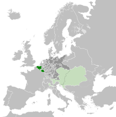
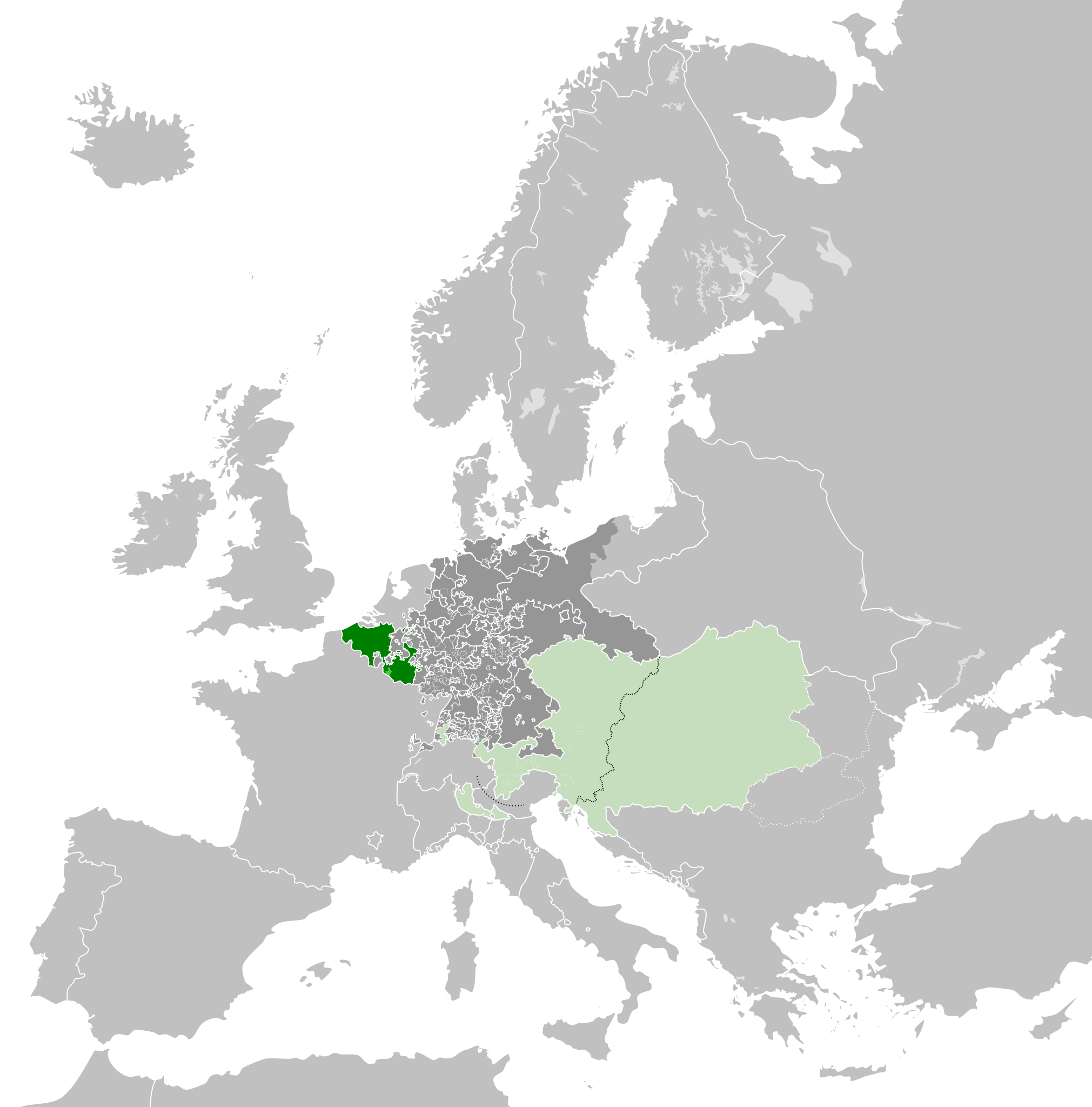
English: A map of the Austrian Netherlands within the Habsburg Monarchy, the Holy Roman Empire and Europe circa 1789.
The Austrian Netherlands
The rest of the Habsburg Monarchy
Deutsch: Eine Landkarte die Österreichische Niederlande c. 1789.
วันที่
(UTC)
แหล่งที่มา
This file was derived from: Europe 1789.svg:
ผู้สร้างสรรค์
Europe_1789.svg: *Blank_map_of_Europe.svg: maix¿?
derivative work: Alphathon
derivative work: Alphathon
เวอร์ชันอื่น
English: This map is part of a series of historical political maps of Europe. All maps by Alphathon and based upon Blank map of Europe.svg unless otherwise stated.
Deutsch: Diese Karte ist Teil einer Serie historischer politischer Europakarten. Solange nicht anders angegeben, wurden alle Karten durch Alphathon auf Basis von Blank map of Europe.svg erstellt, sofern nicht anders angegeben.
Français : Cette carte fait partie d'une série de cartes historiques et politiques d'Europe. Toutes les cartes ont été créées par Alphathon et basées sur Blank map of Europe.svg sauf indication contraire.
Evolution of specific states
Greece/Byzantine Empire
Byzantine Empire: ca. 330 – 1204; 1261 – 1453
Byzantine Empire – 814
Byzantine Empire – 1190
1453 – 1832 Between 1453 and 1832 there was no independent Greek state. During this period the region was ruled by the Byzantine Empire's Turkish successor: the Ottoman Empire.
Greece: 1832 – Today
Kingdom of Greece – 1890
Kingdom of Greece – 1914
Second Hellenic Republic – 1935
Hellenic State – 1942
Kingdom of Greece – 1973
France
Frankish Empire – 814
West Francia – 843
Kingdom of France – 1000
Kingdom of France – 1097
Kingdom of France – 1190
Kingdom of France – 1789
First French Empire – 1812
Kingdom of France – 1815
Kingdom of France – 1839
French Third Republic – 1914
French Third Republic – 1939
French State(Vichy France) – 1942
Provisional Government of the French Republic – 1945-1949
French Fourth Republic – 1946-1957
ดูเพิ่ม:French State (incl. occupation zone) – 1942, Military Administration in France – 1942, Military Administration inBelgium and Northern France – 1942
Germany/Holy Roman Empire
Frankish Empire – 814
East Francia – 843
Holy Roman Empire – 1000
Holy Roman Empire – 1004
Holy Roman Empire – 1097
Holy Roman Empire – 1190
Holy Roman Empire – 1789
ดูเพิ่ม:Kingdom of Germany – 1000
ดูเพิ่ม:Kingdom of Germany – 1004
1806
Confederation of the Rhine – 1812
German Confederation – 1815
North German Confederation – 1870
A confederation of German client-states of the First French Empire
An attempted partial resurrection of the Holy Roman Empire after the Napoleonic wars
A Prussian-dominated successor to the German Confederation following the 1866 Austro-Prussian War
1871
German Empire – 1914
Weimar Republic – 1930
German Reich – November 1938-March 1939
German Reich – Mar-Sep 1939
Greater German Reich – 1942
Federal Republic of Germany(West Germany) – 1956-90
German Democratic Republic(East Germany) – 1956-90
Austria
Habsburg Monarchy – 1714
Habsburg Monarchy – 1789
Austrian Empire – 1812
Austrian Empire – 1815
Austria-Hungary – 1914
Federal State of Austria – 1938
See also:Austrian Empire excluding Lombardy-Venetia – 1815, Kingdom of Lombardy-Venetia – 1815
2013-04-14T01:33:26Z Alphathon 450x456 (853857 Bytes) == {{int:filedesc}} == {{Information |Description={{en|A blank Map of Europe circa 1789. This map also includes a border for the [[:en:Holy Roman Empire|Holy Roman Empire]]. Since there are so many small German states, they h
== {{int:filedesc}} == {{Information |Description={{en|A map of the Austrian Netherlands within the Habsburg Monarchy, the Holy Roman Empire and Europe circa 1789.}}{{de|Eine Landkarte die [[:de:Öste...
A map of Austrian Netherlands within the Habsburg Monarchy, Holy Roman Empire and Europe ca. 1789
ชื่อภาพ
A map of the Austrian Netherlands within the Habsburg Monarchy, and within the Holy Roman Empire, and within Europe, circa 1789. This map is licensed under the Creative Commons Attribution-Share Alike 3.0 Unported license (https://creativecommons.org/licenses/by-sa/3.0/) by the wikimedia user "Alphathon" (http://commons.wikimedia.org/wiki/User:Alphathon), and is based upon "Blank map of Europe.svg" (http://commons.wikimedia.org/wiki/File:Blank_map_of_Europe.svg), the details of which follow:
A blank Map of Europe. Every country has an id which is its ISO-3166-1-ALPHA2 code in lower case. Members of the EU have a class="eu", countries in europe (which I found turkey to be but russia not) have a class="europe". Certain countries are further subdivided the United Kingdom has gb-gbn for Great Britain and gb-nir for Northern Ireland. Russia is divided into ru-kgd for the Kaliningrad Oblast and ru-main for the Main body of Russia. There is the additional grouping #xb for the "British Islands" (the UK with its Crown Dependencies - Jersey, Guernsey and the Isle of Man)
Contributors. Original Image: (http://commons.wikimedia.org/wiki/Image:Europe_countries.svg) Júlio Reis (http://commons.wikimedia.org/wiki/User:Tintazul). Recolouring and tagging with country codes: Marian "maix" Sigler (http://commons.wikimedia.org/wiki/User:Maix) Improved geographical features: http://commons.wikimedia.org/wiki/User:W!B: Updated to reflect dissolution of Serbia & Montenegro: http://commons.wikimedia.org/wiki/User:Zirland Updated to include British Crown Dependencies as seperate entities and regroup them as "British Islands", with some simplifications to the XML and CSS: James Hardy (http://commons.wikimedia.org/wiki/User:MrWeeble) Validated (http://commons.wikimedia.org/wiki/User:CarolSpears) Changed the country code of Serbia to RS per http://en.wikipedia.org/wiki/Serbian_country_codes and the file http://www.iso.org/iso/iso3166_en_code_lists.txt (http://commons.wikimedia.org/wiki/User:TimothyBourke) Uploaded on behalf of User:Checkit, direct complaints to him plox: 'Moved countries out of the "outlines" group, removed "outlines" style class, remove separate style information for Russia' (http://commons.wikimedia.org/wiki/User:Collard) Updated various coastlines and boarders and added various islands not previously shown (details follow). Added Kosovo and Northern Cyprus as disputed territories. Moved major lakes to their own object and added more. List of updated boarders/coastlines: British Isles (+ added Isle of Wight, Skye, various smaller islands), the Netherlands, Germany, Czech Republic, Denmark, Sweden, Finland, Poland, Kaliningrad Oblast of the Russian Federation (and minor tweaks to Lithuania), Ukraine, Moldova (minor), Romania, Bulgaria, Turkey, Greece, F.Y.R. Macedonia, Serbia, Bosnia and Herzegovina, Montenegro, Albania, Croatia, Italy (mainland and Sicily), Malta (http://commons.wikimedia.org/wiki/User:Alphathon). Added Bornholm (http://commons.wikimedia.org/wiki/User:Heb)
ไฟล, austrian, netherlands, 1789, ไฟล, ประว, ไฟล, หน, าท, ภาพน, การใช, ไฟล, วนกลาง, อม, ลเก, ยวก, บภาพขนาดของต, วอย, าง, ของไฟล, กเซล, ความละเอ, ยดอ, กเซล, กเซล, กเซล, กเซล, กเซล, ภาพท, ความละเอ, ยดส, งกว, 8206, ไฟล, กเซล, ขนาดไฟล, โลไบต, ปภาพหร, อไฟล, เส, ยงน. ifl prawtiifl hnathimiphaphni karichiflswnklang khxmulekiywkbphaphkhnadkhxngtwxyang PNG nikhxngifl SVG ni 450 456 phikesl khwamlaexiydxun 237 240 phikesl 474 480 phikesl 758 768 phikesl 1 011 1 024 phikesl 2 021 2 048 phikesl duphaphthimikhwamlaexiydsungkwa 8206 ifl SVG 450 456 phikesl khnadifl 858 kiolibt rupphaphhruxiflesiyngni tnchbbxyuthi khxmmxns raylaexiyddanlang epnkhxkhwamthiaesdngphlcak ifltnchbbinkhxmmxns khxmmxnsepnewbistinokhrngkarsahrbekbrwbrwmsuxesri thi khunsamarthchwyid khwamyx khaxthibayAustrian Netherlands 1789 svg English A map of the Austrian Netherlands within the Habsburg Monarchy the Holy Roman Empire and Europe circa 1789 The Austrian Netherlands The rest of the Habsburg MonarchyDeutsch Eine Landkarte die Osterreichische Niederlande c 1789 wnthi 14 emsayn ph s 2556 13 25 UTC aehlngthima This file was derived from Europe 1789 svg phusrangsrrkh Europe 1789 svg Blank map of Europe svg maix derivative work Alphathon derivative work Alphathonewxrchnxun English This map is part of a series of historical political maps of Europe All maps by Alphathon and based upon Blank map of Europe svg unless otherwise stated Deutsch Diese Karte ist Teil einer Serie historischer politischer Europakarten Solange nicht anders angegeben wurden alle Karten durch Alphathon auf Basis von Blank map of Europe svg erstellt sofern nicht anders angegeben Francais Cette carte fait partie d une serie de cartes historiques et politiques d Europe Toutes les cartes ont ete creees par Alphathon et basees sur Blank map of Europe svg sauf indication contraire Evolution of specific statesGreece Byzantine Empire Byzantine Empire ca 330 1204 1261 1453Byzantine Empire 814 Byzantine Empire 11901453 1832Between 1453 and 1832 there was no independent Greek state During this period the region was ruled by the Byzantine Empire s Turkish successor the Ottoman Empire Greece 1832 TodayKingdom of Greece 1890 Kingdom of Greece 1914 Second Hellenic Republic 1935 Hellenic State 1942 Kingdom of Greece 1973 France Frankish Empire 814 West Francia 843 Kingdom of France 1000 Kingdom of France 1097 Kingdom of France 1190Kingdom of France 1789 First French Empire 1812 Kingdom of France 1815 Kingdom of France 1839 French Third Republic 1914French Third Republic 1939 French State Vichy France 1942 Provisional Government of the French Republic 1945 1949 French Fourth Republic 1946 1957duephim French State incl occupation zone 1942 Military Administration in France 1942 Military Administration in Belgium and Northern France 1942 Germany Holy Roman Empire Frankish Empire 814 East Francia 843 Holy Roman Empire 1000 Holy Roman Empire 1004 Holy Roman Empire 1097 Holy Roman Empire 1190 Holy Roman Empire 1789duephim Kingdom of Germany 1000 duephim Kingdom of Germany 10041806Confederation of the Rhine 1812 German Confederation 1815 North German Confederation 1870A confederation of German client states of the First French Empire An attempted partial resurrection of the Holy Roman Empire after the Napoleonic wars A Prussian dominated successor to the German Confederation following the 1866 Austro Prussian War1871German Empire 1914 Weimar Republic 1930 German Reich November 1938 March 1939 German Reich Mar Sep 1939 Greater German Reich 1942 Federal Republic of Germany West Germany 1956 90 German Democratic Republic East Germany 1956 90 Austria Habsburg Monarchy 1714 Habsburg Monarchy 1789 Austrian Empire 1812 Austrian Empire 1815 Austria Hungary 1914 Federal State of Austria 1938See also Austrian Empire excluding Lombardy Venetia 1815 Kingdom of Lombardy Venetia 1815 Hungary Approx territory of the Mayars in 814 Kingdom of Hungary 1000 Kingdom of Hungary 1097 Kingdom of Hungary 1190 Habsburg Monarchy 1714 Habsburg Monarchy 1789Austrian Empire 1812 Austrian Empire 1815 Austria Hungary 1914 Kingdom of Hungary 1929 1938 Kingdom of Hungary 1942 Second Hungarian Republic 1945 1949duephim Austrian Empire excluding Lombardy Venetia 1815 Kingdom of Lombardy Venetia 1815Hungarian People s Republic 1956 1990 Italy Northern Italy774 1176 1805Frankish Empire 814 Middle Francia 843 Kingdom of Italy Holy Roman Empire 10001805 1814Kingdom of Italy Napoleonic 1812Southern Italy774 1860Norman possessions in southern Italy 1097 Norman Kingdom of Sicily 1190 Kingdom of the Two Sicilies 1839Risorgimento1860 20xxKingdom of Sardinia 1860 Kingdom of Italy 1861 Kingdom of Italy 1870 Kingdom of Italy 1914 Kingdom of Italy 1936 Kingdom of Italy 1943 Italian Social Republic 1943 Poland Duchy of Poland 1000 Kingdom of Poland 1097 Kingdom of Poland 1190 Polish Lithuanian Commonwealth 1714 Polish Lithuanian Commonwealth 1789Duchy of Warsaw 1812 Congress Poland 1815 Second Polish Republic 1930 General Government 1942 Polish People s Republic 1956 90See also Free City of Danzig 1812 See also Free City of Danzig 1930 Brandenburg the Teutonic Order and Prussia Kingdom of Prussia 1714 Kingdom of Prussia 1789 Kingdom of Prussia 1815 Kingdom of Prussia 1815 Kingdom of Prussia 1870 9th Century814 Blank map of Europe 814 svg Francia Frankish Empire Carolingian Empire Byzantine East Roman Empire First Bulgarian Empire Kingdom of Asturias Approx territory of the Magyars 843 Blank map of Europe 843 svg West Francia Middle Francia East Francia 11th Century1000 Blank map of Europe 1000 svg Holy Roman Empire Kingdom of Germany Kingdom of Italy Kingdom of Arles Arelat Burgundy Kingdom of France Kingdom of Hungary Duchy of Poland Duchy of Bohemia 1004 Blank map of Europe 1004 svg Holy Roman Empire Kingdom of Germany 1097 Blank map of Europe 1097 svg Holy Roman Empire Kingdom of France Kingdom of Hungary Kingdoms of Castile and Leon Norman possessions in Southern Italy 12th Century1190 Blank map of Europe 1190 svg Holy Roman Empire Byzantine East Roman Empire Angevin Empire England Kingdom of France Kingdom of Hungary Kingdom of Poland Norman Kingdom of Sicily Kingdom of Aragon Kingdoms of Castile and Leon Kingdom of Portugal 18th Century1714 Blank map of Europe 1714 svg Kingdom of Prussia Habsburg Monarchy Polish Lithuanian Commonwealth Swiss Confederacy 1789 Europe 1789 svg Holy Roman Empire Alternative version excluding extra imperial Prussian and Habsburg territory derivative work by TRAJAN 117 Habsburg Monarchy alternative file Habsburg Hereditary Lands derivative work by TRAJAN 117 Austrian Netherlands Duchy of Milan Kingdom of Prussia Electorate of Brunswick Luneburg Electorate of Bavaria Electorate of Saxony Duchy of Wurttemberg Duchy of Mecklenburg Schwerin Duchy of Holstein Landgraviate of Hesse Kassel Ecclesiastical lands of the Holy Roman Empire Republic of Venice Papal States Grand Duchy of Tuscany Kingdom of Sardinia Republic of Genoa Polish Lithuanian Commonwealth Kingdom of Sweden Kingdom of Great Britain Kingdom of Ireland derivative work by Elevatorrailfan Kingdom of France derivative work by TRAJAN 117 Cropped version derivative work by Dbachmann Dutch Republic derivative work by TRAJAN 117 Kingdom of Spain derivative work by TRAJAN 117 Voivodeship of Wallachia derivative work by TRAJAN 117 Voivodeship of Moldavia derivative work by TRAJAN 117 19th Century1812 Europe at the height of Napoleon s power Blank map of Europe 1812 svg First French Empire and its satellite states French Empire derivative work by TRAJAN 117 Confederation of the Rhine derivative work by TRAJAN 117 Austrian Empire derivative work by TRAJAN 117 Kingdom of Bavaria Kingdom of Westphalia Kingdom of Saxony Principality of Erfurt derivative work by OwenBlacker Free City of Danzig derivative work by TRAJAN 117 Duchy of Warsaw derivative work by TRAJAN 117 Prince Bishopric of Montenegro derivative work by TRAJAN 117 Territory of the First Serbian Uprising derivative work by TRAJAN 117 Voivodeship of Wallachia derivative work by TRAJAN 117 Voivodeship of Moldavia derivative work by TRAJAN 117 Kingdom of Italy derivative work by TRAJAN 117 Kingdom of Spain derivative work by TRAJAN 117 1815 Europe following the Congress of Vienna which restored much of the old order following the Napoleonic wars Blank map of Europe 1815 svg German Confederation German Confederation alt colour scheme derivative work by TRAJAN 117 Austrian Empire Austrian Empire incl Lombardy Venetia derivative work by TRAJAN 117 Kingdom of Lombardy Venetia Kingdom of Prussia Kingdom of Bavaria Kingdom of Hanover Kingdom of Wurttemberg Kingdom of Saxony Grand Duchy of Baden United Kingdom of the Netherlands Grand Duchy of Luxembourg Kingdom of Sardinia Free Independent and Strictly Neutral City of Krakow Congress Poland Kingdom of France derivative work by TRAJAN 117 1839 Blank map of Europe 1839 svgderivative work by ArnoldPlaton Kingdom of France derivative work by Elevatorrailfan Kingdom of the Two Sicilies derivative work by Elevatorrailfan 1860 Blank map of Europe 1860 svg Kingdom of Sardinia 1861 Blank map of Europe 1861 svg Kingdom of Italy 1870 Blank map of Europe 1870 svg North German Confederation Kingdom of Prussia Kingdom of Italy 1890 Blank map of Europe 1890 svg Principality of Bulgaria derivative work by TRAJAN 117 Kingdom of Greece derivative work by TRAJAN 117 Principality of Montenegro derivative work by TRAJAN 117 Kingdom of Portugal derivative work by TRAJAN 117 Kingdom of Romania derivative work by TRAJAN 117 20th Century1914 Blank map of Europe 1914 svg German Empire Province of Pomerania Austria Hungary derivative work by TRAJAN 117 French Third Republic derivative work by Semhur Grand Duchy Principality of Finland derivative work by TRAJAN 117 Kingdom of Italy derivative work by WindEwriX Kingdom of Bulgaria derivative work by TRAJAN 117 Kingdom of Greece derivative work by TRAJAN 117 Kingdom of Serbia derivative work by TRAJAN 117 Kingdom of Montenegro derivative work by TRAJAN 117 Kingdom of Romania derivative work by TRAJAN 117 1929 1938 Blank map of Europe 1929 1938 svg The Weimar Republic Czechoslovakia Czechoslovak Republic derivative work by TRAJAN 117 Free City of Danzig Albanian Kingdom derivative work by TRAJAN 117 Second Polish Republic Second Hellenic Republic Greece derivative work by TRAJAN 117 Second Spanish Republic derivative work by TRAJAN 117 Kingdom of Yugoslavia derivative work by TRAJAN 117 Kingdom of Italy derivative work by TRAJAN 117 Spanish Morocco derivative work by TRAJAN 117 The Little Entente derivative work by Tschechoslowakei Irish Free State derivative work by Elevatorrailfan Federal State of Austria derivative work by TRAJAN 117 Kingdom of Hungary October 1938 March 1939 Blank map of Europe October 1938 March 1939 svg German Reich Nazi Germany derivative work by TRAJAN 117 First Czechoslovak Republic Czechoslovakia derivative work by TRAJAN 117 Kingdom of Romania derivative work by TRAJAN 117 Albanian Kingdom derivative work by TRAJAN 117 March September 1939 Blank map of Europe March September 1939 svgderivative work by Goran tek en German Reich Nazi Germany derivative work by DIREKTOR French Third Republic derivative work by DIREKTOR 1942 Europe 1942 svg Europe in 1942 coloured with legend and labels derivative work by Goran tek en Europe in 1942 coloured with key derivative work by Goran tek en Europe in 1942 coloured no key derivative work by Goran tek en Axis Occupation of Europe 1942 derivative work by TRAJAN 117 German Reich occupations derivative work by DIREKTOR 11 19 November derivative work by DIREKTOR Greater German Reich Nazi Germany derivative work by TRAJAN 117 Alternative file derivative work by DIREKTOR General Government Poland derivative work by TRAJAN 117 Protectorate of Bohemia and Moravia derivative work by TRAJAN 117 French State incl occupation zone derivative work by TRAJAN 117 French State excl occupation zone derivative work by DIREKTOR Militarverwaltung in Frankreich derivative work by TRAJAN 117 Militarverwaltung in Belgien und Nordfrankreich derivative work by TRAJAN 117 Reichskommissariat Niederlande derivative work by TRAJAN 117 Reichskommissariat Norwegen derivative work by TRAJAN 117 Reichskommissariat Ostland derivative work by TRAJAN 117 Reichskommissariat Ukraine derivative work by TRAJAN 117 General District of Crimea derivative work by TRAJAN 117 Republic of Finland derivative work by TRAJAN 117 Kingdom of Hungary derivative work by TRAJAN 117 Kingdom of Romania derivative work by TRAJAN 117 Kingdom of Bulgaria derivative work by TRAJAN 117 Albanian Kingdom derivative work by TRAJAN 117 Kingdom of Iceland derivative work by TRAJAN 117 Hellenic State Greece derivative work by TRAJAN 117 Territory of the Military Commander in Serbia Occupied Serbia Independent State of Croatia derivative work by TRAJAN 117 Slovak State First Slovak Republic derivative work by TRAJAN 117 Italian Governorate or Kingdom of Montenegro derivative work by TRAJAN 117 Italian Social Republic derivative work by Elevatorrailfan Italian Social Republic in 1943 derivative work by Elevatorrailfan Ireland derivative work by Elevatorrailfan 1956 1990 Blank map of Europe 1956 1990 svg People s Socialist Republic of Albania derivative work by StalwartUK People s Republic of Bulgaria derivative work by StalwartUK Czechoslovakia East Germany German Democratic Republic derivative work by StalwartUK West Germany Federal Republic of Germany derivative work by StalwartUK Kingdom of Greece derivative work by TRAJAN 117 People s Republic of Hungary derivative work by StalwartUK Polish People s Republic derivative work by StalwartUK People s Socialist Republic of Romania derivative work by StalwartUK Socialist Federal Republic of Yugoslavia derivative work by StalwartUK Francoist Spain derivative work by TRAJAN 117 NATO and the Warsaw Pact circa 1973 karxnuyatichsiththi khapheca inthanaphuthuxlikhsiththikhxngphaphhruxsuxni xnuyatihichphaphhruxsuxniphayitenguxnikhtxipniiflnixyuphayitsyyaxnuyat khriexthifkhxmmxns aebbaesdngthima xnuyataebbediywkn 3 0 tnchbbkhunsamarth thicaaebngpn thicathasaena aeckcay aelasngngandngklawtxip thicaeriyberiyngihm thicaddaeplngngandngklaw phayitenguxnikhtxipni aesdngthima khuntxngihekiyrtiecakhxngnganxyangehmaasm odyephimlingkipyngsyyaxnuyat aelarabuhakmikarepliynaeplng khunxacthaechnniidinrupaebbidkidtamkhwr aettxngimichinlksnathiaenawaphuihxnuyatsnbsnunkhunhruxkarichngankhxngkhun xnuyataebbediywkn hakkhunddaeplng epliynrup hruxtxetimnganni khuntxngichsyyaxnuyataebbediywknhruxaebbthiehmuxnkbsyyaxnuyatthiichkbnganniethannhttps creativecommons org licenses by sa 3 0 CC BY SA 3 0 Creative Commons Attribution Share Alike 3 0 true true bnthukkarxphohld This image is a derivative work of the following images File Europe 1789 svg licensed with Cc by sa 3 0 2013 04 14T03 44 26Z Alphathon 450x456 858577 Bytes Corrected some errors in northern Italy 2013 04 14T01 38 01Z Alphathon 450x456 853881 Bytes tweaked again 2013 04 14T01 36 10Z Alphathon 450x456 853881 Bytes Tweaked Holy Roman Empire border style 2013 04 14T01 33 26Z Alphathon 450x456 853857 Bytes int filedesc Information Description en A blank Map of Europe circa 1789 This map also includes a border for the en Holy Roman Empire Holy Roman Empire Since there are so many small German states they hUploaded with derivativeFXkhabrryayodyyxithyephimkhabrryaythrrthdediywephuxkhyaykhwamwaiflnimixairixethmthiaesdngxyuiniflniprakxbdwysthanalikhsiththimilikhsiththisyyaxnuyatCreative Commons Attribution ShareAlike 3 0 Unported xngkvs prawtiifl khlikwnthi ewlaephuxduiflthipraktinkhnann wnthi ewlarupyxkhnadphuichkhwamehn pccubn14 38 17 tulakhm 2564450 456 858 kiolibt Fenn O maniCWrong file 14 38 17 tulakhm 2564450 456 800 kiolibt Fenn O maniCFixed the Russo Swedish border to match the Treaty of Abo of 1743 14 36 17 tulakhm 2564450 456 858 kiolibt Fenn O maniCFixed the Russo Swedish border to match the Treaty of Abo of 1743 03 34 19 emsayn 2556450 456 878 kiolibt AlphathonStyle change 01 34 19 emsayn 2556450 456 857 kiolibt AlphathonVarious fixes 03 31 16 emsayn 2556450 456 854 kiolibt AlphathonCorrected Scandinavian borders 06 18 15 emsayn 2556450 456 839 kiolibt AlphathonChanged colour of the remainder of the Habsburg Monarchy 20 29 14 emsayn 2556450 456 839 kiolibt Alphathon int filedesc Information Description en A map of the Austrian Netherlands within the Habsburg Monarchy the Holy Roman Empire and Europe circa 1789 de Eine Landkarte die de Oste hnathimiphaphni hnatxipni oyngmathiphaphni enethxraelndkhxngxxsetriy karichiflswnklang wikixuntxipniichiflni karichbn ar wikipedia org الأراضي المنخفضة النمساوية karichbn ast wikipedia org Paises Baxos Austriacos karichbn bg wikipedia org Avstrijska Niderlandiya karichbn cs wikipedia org Rakouske Nizozemi karichbn en wikipedia org Austrian Netherlands karichbn eo wikipedia org Aŭstria Nederlando karichbn et wikipedia org Austria Madalmaad karichbn eu wikipedia org Austriar Herbehereak karichbn fa wikipedia org هلند اتریش karichbn fi wikipedia org Itavallan Alankomaat karichbn fr wikipedia org Wikipedia Atelier graphique Cartes Archives octobre 2013 karichbn he wikipedia org ארצות השפלה האוסטריות karichbn id wikipedia org Belanda Austria karichbn it wikipedia org Monarchia asburgica Paesi Bassi austriaci karichbn ja wikipedia org 利用者 Appassionata3 sandbox karichbn ko wikipedia org 오스트리아령 네덜란드 karichbn mk wikipedia org Avstriski Niski Zemјi karichbn pt wikipedia org Paises Baixos Austriacos karichbn tr wikipedia org Avusturya Hollandasi karichbn uk wikipedia org Avstrijski Niderlandi karichbn vi wikipedia org Ha Lan Ao Thanh vien Windrain Bach khoa đặc biệt karichbn www wikidata org Q700283 karichbn zh wikipedia org 奥属尼德兰khxmulekiywkbphaph phaphnimikhxmulephimetim sungswnihymacakklxngdicitxlhruxsaeknenxrthisamarthekbkhxmuldngklawiwrwmkbphaphid thaphaphnithukprbprungaekikhhruxepliynaeplngcakedim khxmulbangxyangcayngkhngimepliynaeplngehmuxnphaphthithukprbprungaekikhnnchuxeruxngsnA map of Austrian Netherlands within the Habsburg Monarchy Holy Roman Empire and Europe ca 1789chuxphaphA map of the Austrian Netherlands within the Habsburg Monarchy and within the Holy Roman Empire and within Europe circa 1789 This map is licensed under the Creative Commons Attribution Share Alike 3 0 Unported license https creativecommons org licenses by sa 3 0 by the wikimedia user Alphathon http commons wikimedia org wiki User Alphathon and is based upon Blank map of Europe svg http commons wikimedia org wiki File Blank map of Europe svg the details of which follow A blank Map of Europe Every country has an id which is its ISO 3166 1 ALPHA2 code in lower case Members of the EU have a class eu countries in europe which I found turkey to be but russia not have a class europe Certain countries are further subdivided the United Kingdom has gb gbn for Great Britain and gb nir for Northern Ireland Russia is divided into ru kgd for the Kaliningrad Oblast and ru main for the Main body of Russia There is the additional grouping xb for the British Islands the UK with its Crown Dependencies Jersey Guernsey and the Isle of Man Contributors Original Image http commons wikimedia org wiki Image Europe countries svg Julio Reis http commons wikimedia org wiki User Tintazul Recolouring and tagging with country codes Marian maix Sigler http commons wikimedia org wiki User Maix Improved geographical features http commons wikimedia org wiki User W B Updated to reflect dissolution of Serbia amp Montenegro http commons wikimedia org wiki User Zirland Updated to include British Crown Dependencies as seperate entities and regroup them as British Islands with some simplifications to the XML and CSS James Hardy http commons wikimedia org wiki User MrWeeble Validated http commons wikimedia org wiki User CarolSpears Changed the country code of Serbia to RS per http en wikipedia org wiki Serbian country codes and the file http www iso org iso iso3166 en code lists txt http commons wikimedia org wiki User TimothyBourke Uploaded on behalf of User Checkit direct complaints to him plox Moved countries out of the outlines group removed outlines style class remove separate style information for Russia http commons wikimedia org wiki User Collard Updated various coastlines and boarders and added various islands not previously shown details follow Added Kosovo and Northern Cyprus as disputed territories Moved major lakes to their own object and added more List of updated boarders coastlines British Isles added Isle of Wight Skye various smaller islands the Netherlands Germany Czech Republic Denmark Sweden Finland Poland Kaliningrad Oblast of the Russian Federation and minor tweaks to Lithuania Ukraine Moldova minor Romania Bulgaria Turkey Greece F Y R Macedonia Serbia Bosnia and Herzegovina Montenegro Albania Croatia Italy mainland and Sicily Malta http commons wikimedia org wiki User Alphathon Added Bornholm http commons wikimedia org wiki User Heb Released under CreativeCommons Attribution ShareAlike http creativecommons org licenses by sa 2 5 khwamkwang450khwamsung456 ekhathungcak https th wikipedia org wiki ifl Austrian Netherlands 1789 svg, wikipedia, วิกิ หนังสือ, หนังสือ, ห้องสมุด,