ภาพ ethnographic map นี้ ควรจะถูกสร้างใหม่เป็นกราฟิกส์เวกเตอร์ ซึ่งมีข้อดีอีกหลายประการ ดูเพิ่มเติมที่คอมมอนส์:สื่อต้องการเก็บกวาดสำหรับสารสนเทศเพิ่มเติม หากภาพนี้มีในรูปแบบกราฟิกส์เวกเตอร์อยู่แล้ว กรุณาอัปโหลดและแทนที่แม่แบบนี้ด้วย {{vector version available|ชื่อภาพใหม่}} แนะนำเป็นอย่างยิ่งให้ตั้งชื่อไฟล์เวกเตอร์ใหม่นั้นในรูปแบบ "Bia-map-indian-reservations-usa.svg" แล้วใส่แม่แบบ Vector version available (หรือ Vva) ซึ่งไม่ต้องใช้พารามิเตอร์ ชื่อภาพใหม่
This file has been superseded by Indian reservations in the Continental United States.png. It is recommended to use the other file. Please note that deleting superseded images requires consent.
Reason to use the other file: "Updated to include newly-established reservations"
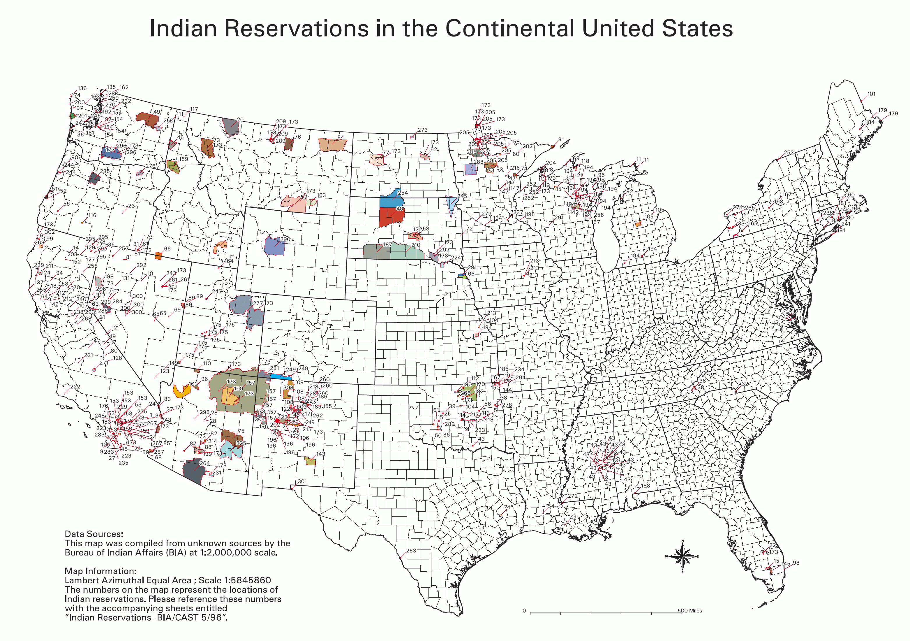
Source
National Park Service; see also: Bureau of Indian Affairs
Key
0 No Data
Absentee Shawnee
Acoma
Agua Caliente
Alabama-Coushatta
Alabama-Quassarte Creeks
Allegany
Apache
Bad River
Barona Ranch
Battle Mountain
Bay Mills
Benton Paiute
Berry Creek
Big Bend
Big Cypress
Big Lagoon
Big Pine
Big Valley
Bishop
Blackfeet
Bridgeport
Brighton
Burns Paiute Colony
Cabezon
Caddo
Cahuilla
Campo
Camp Verde
Canoncito
Capitan Grande
Carson
Catawba
Cattaraugus
Cayuga
Cedarville
Chehalis
Chemehuevi
Cherokee
Cheyenne-Arapahoe
Cheyenne River
Chickasaw
Chitimacha
Choctaw
Citizen Band Of Potawatomi
Cochiti
Coeur D'alene
Cold Springs
Colorado River
Colville
Comanche
Coos, Lower Umpqua & Siuslaw
Coquille
Cortina
Coushatta
Cow Creek
Creek
Crow
Crow Creek
Cuyapaipe
Deer Creek
Delaware
Devils Lake
Dresslerville Colony
Dry Creek
Duckwater
Duck Valley
Eastern Shawnee
East Cocopah
Ely Colony
Enterprise
Fallon/Stillwater
Flandreau Indian School
Flathead
Fond Du Lac
Fort Apache
Fort Belknap
Fort Berthold
Fort Bidwell
Fort Hall
Fort Independence
Fort Mcdermitt
Fort Mcdowell
Fort Mohave
Fort Peck
Fort Yuma
Ft. Sill Apache
Gila Bend
Gila River
Goshute
Grande Ronde
Grand Portage
Grand Traverse
Greater Leech Lake
Grindstone
Hannahville
Havasupai
Hoh
Hollywood
Hoopa Valley
Hopi
Houlton Maliseets
Hualapai
Inaja
Iowa
Isabella
Isleta
Jackson
Jemez
Jicarilla
Kaibab
Kalispel
Kaw
Kialegee Creek
Kickapoo
Kiowa
Klamath
Kootenai
L'anse
Lac Courte Oreilles
Lac Du Flambeau
Lac Vieux Desert
Laguna
Las Vegas
Laytonville
La Jolla
La Posta
Likely
Lone Pine
Lookout
Los Coyotes
Lovelock Colony
Lower Brule
Lower Elwah
Lower Sioux
Lummi
Makah
Manchester
Manzanita
Maricopa
Mashantucket Pequot
Mattaponi
Menominee
Mescalero
Miami
Miccosukee
Middletown
Mille Lacs
Mission
Moapa
Modoc
Mole Lake
Montgomery Creek
Morongo
Muckleshoot
Nambe
Narragansett
Navajo
Nett Lake
Nez Perce
Nipmoc-Hassanamisco
Nisqually
Nooksack
Northern Cheyenne
Northwestern Shoshone
Oil Springs
Omaha
Oneida
Onondaga
Ontonagon
Osage
Otoe-Missouri
Ottawa
Out
Ozette
Paiute
Pala
Pamunkey
Pascua Yaqui
Passamaquoddy
Paucatauk Pequot
Paugusett
Pawnee
Pechanga
Penobscot
Peoria
Picuris
Pine Ridge
Poarch Creek
Pojoaque
Ponca
Poosepatuck
Port Gamble
Port Madison
Potawatomi
Prairie Isle
Puertocito
Puyallup
Pyramid Lake
Quapaw
Quillayute
Quinault
Ramah
Ramona
Red Cliff
Red Lake
Reno-Sparks
Rincon
Roaring Creek
Rocky Boys
Rosebud
Round Valley
Rumsey
Sac And Fox
Salt River
Sandia
Sandy Lake
Santa Ana
Santa Clara
Santa Domingo
Santa Rosa
Santa Rosa (North)
Santa Ynez
Santa Ysabel
Santee
San Carlos
San Felipe
San Ildefonso
San Juan
San Manual
San Pasqual
San Xavier
Sauk Suiattle
Seminole
Seneca-Cayuga
Sequan
Shagticoke
Shakopee
Sheep Ranch
Sherwood Valley
Shingle Spring
Shinnecock
Shoalwater
Shoshone
Siletz
Sisseton
Skokomish
Skull Valley
Soboba
Southern Ute
Spokane
Squaxon Island
St. Croix
St. Regis
Standing Rock
Stewarts Point
Stockbridge Munsee
Summit Lake
Susanville
Swinomish
Taos
Te-Moak
Tesuque
Texas Kickapoo
Tohono O'odham
Tonawanda
Tonikawa
Torres Martinez
Toulumne
Trindad
Tulalip
Tule River
Tunica-Biloxi
Turtle Mountains
Tuscarora
Twentynine Palms
Umatilla
Uintah And Ouray
United Keetoowah Band Of Cherokee
Upper Sioux
Upper Skagit
Ute Mountain
Vermilion Lake
Viejas
Walker River
Warm Springs
Washoe
West Cocopah
White Earth
Wichita
Wind River
Winnebago
Winnemucca
Woodford Indian Community
Wyandotte
Xl Ranch
Yakama
Yankton
Yavapai
Yerington
Yomba
Ysleta Del Sur
Yurok
Zia
Zuni
Info contained in image
Data Sources: This map was compiled from unknown sources by the Bureau of Indian Affairs (BIA) at 1:2,000,000 scale.
Map Information: Lambert Azimuthal Equal Area; Scale 1:5845860 The numbers on the map represent the locations of Indian reservations. Please reference these numbers with the accompanying sheets entitled Indian Reservations - BIA/CAST 5/96
BIA map of Indian Reservations in the Continental United States. An index to the reservations of the map can be found on the National NAGPRA site, http://www.cr.nps.gov/nagpra/.
หน้าที่มีภาพนี้
ไม่มีหน้าใดโยงมาที่ภาพนี้
การใช้ไฟล์ส่วนกลาง
วิกิอื่นต่อไปนี้ใช้ไฟล์นี้:
Класификация на коренното население на Америките
Portal:Geografia
Portal:Geografia/Articles seleccionats
Plantilla:Article geogràfic de la setmana 46
Usuari:Lluismdies/El meu obrador
Llista de reserves índies dels Estats Units
País amerindi
Indianerreservat
Indianerpolitik der Vereinigten Staaten
Indianerkriege
Native American Graves Protection and Repatriation Act
Wikipedia Diskussion:Hauptseite/Artikel des Tages/Archiv/Vorschläge/2019/Q1
Wikipedia:Hauptseite/Archiv/31. März 2019
Public Law 280
การใช้บน de.wikiversity.org
Γεωγραφία&Ιστορία/Indianerpolitik
Wikipedia:Reference desk/Archives/Humanities/2015 June 15
User:Joelton Ivson/Gather lists/24319 – Indígenas América do Norte
ไฟล, indian, reservations, ไฟล, ประว, ไฟล, หน, าท, ภาพน, การใช, ไฟล, วนกลางขนาดของต, วอย, างน, กเซล, ความละเอ, ยดอ, กเซล, กเซล, กเซล, กเซล, กเซล, กเซล, ภาพท, ความละเอ, ยดส, งกว, 8206, กเซล, ขนาดไฟล, โลไบต, ชน, ดไมม, image, ปภาพหร, อไฟล, เส, ยงน, นฉบ, บอย, คอมม. ifl prawtiifl hnathimiphaphni karichiflswnklangkhnadkhxngtwxyangni 800 563 phikesl khwamlaexiydxun 320 225 phikesl 640 451 phikesl 1 024 721 phikesl 1 280 901 phikesl 2 560 1 803 phikesl 3 124 2 200 phikesl duphaphthimikhwamlaexiydsungkwa 8206 3 124 2 200 phikesl khnadifl 457 kiolibt chnidimm image png rupphaphhruxiflesiyngni tnchbbxyuthi khxmmxns raylaexiyddanlang epnkhxkhwamthiaesdngphlcak ifltnchbbinkhxmmxns khxmmxnsepnewbistinokhrngkarsahrbekbrwbrwmsuxesri thi khunsamarthchwyid phaph nbsp ethnographic map nbsp ni khwrcathuksrangihmepnkrafiksewketxr sungmikhxdixikhlayprakar duephimetimthikhxmmxns suxtxngkarekbkwadsahrbsarsnethsephimetim hakphaphnimiinrupaebbkrafiksewketxrxyuaelw krunaxpohldaelaaethnthiaemaebbnidwy vector version available i chuxphaphihm i aenanaepnxyangyingihtngchuxiflewketxrihmnninrupaebb Bia map indian reservations usa svg aelwisaemaebb Vector version available hrux Vva sungimtxngichpharamietxr chuxphaphihm nbsp This file has been superseded by Indian reservations in the Continental United States png It is recommended to use the other file Please nbsp note nbsp that deleting superseded images requires consent Reason to use the other file Updated to include newly established reservations enuxha 1 Source 2 Key 3 Info contained in image 4 khwamyx 5 karxnuyatichsiththi 6 derivative works Source National Park Service see also Bureau of Indian Affairs Key nbsp 0 nbsp nbsp nbsp No Data Absentee Shawnee Acoma Agua Caliente Alabama Coushatta Alabama Quassarte Creeks Allegany Apache Bad River Barona Ranch Battle Mountain Bay Mills Benton Paiute Berry Creek Big Bend Big Cypress Big Lagoon Big Pine Big Valley Bishop Blackfeet Bridgeport Brighton Burns Paiute Colony Cabezon Caddo Cahuilla Campo Camp Verde Canoncito Capitan Grande Carson Catawba Cattaraugus Cayuga Cedarville Chehalis Chemehuevi Cherokee Cheyenne Arapahoe Cheyenne River Chickasaw Chitimacha Choctaw Citizen Band Of Potawatomi Cochiti Coeur D alene Cold Springs Colorado River Colville Comanche Coos Lower Umpqua amp Siuslaw Coquille Cortina Coushatta Cow Creek Creek Crow Crow Creek Cuyapaipe Deer Creek Delaware Devils Lake Dresslerville Colony Dry Creek Duckwater Duck Valley Eastern Shawnee East Cocopah Ely Colony Enterprise Fallon Stillwater Flandreau Indian School Flathead Fond Du Lac Fort Apache Fort Belknap Fort Berthold Fort Bidwell Fort Hall Fort Independence Fort Mcdermitt Fort Mcdowell Fort Mohave Fort Peck Fort Yuma Ft Sill Apache Gila Bend Gila River Goshute Grande Ronde Grand Portage Grand Traverse Greater Leech Lake Grindstone Hannahville Havasupai Hoh Hollywood Hoopa Valley Hopi Houlton Maliseets Hualapai Inaja Iowa Isabella Isleta Jackson Jemez Jicarilla Kaibab Kalispel Kaw Kialegee Creek Kickapoo Kiowa Klamath Kootenai L anse Lac Courte Oreilles Lac Du Flambeau Lac Vieux Desert Laguna Las Vegas Laytonville La Jolla La Posta Likely Lone Pine Lookout Los Coyotes Lovelock Colony Lower Brule Lower Elwah Lower Sioux Lummi Makah Manchester Manzanita Maricopa Mashantucket Pequot Mattaponi Menominee Mescalero Miami Miccosukee Middletown Mille Lacs Mission Moapa Modoc Mole Lake Montgomery Creek Morongo Muckleshoot Nambe Narragansett Navajo Nett Lake Nez Perce Nipmoc Hassanamisco Nisqually Nooksack Northern Cheyenne Northwestern Shoshone Oil Springs Omaha Oneida Onondaga Ontonagon Osage Otoe Missouri Ottawa Out Ozette Paiute Pala Pamunkey Pascua Yaqui Passamaquoddy Paucatauk Pequot Paugusett Pawnee Pechanga Penobscot Peoria Picuris Pine Ridge Poarch Creek Pojoaque Ponca Poosepatuck Port Gamble Port Madison Potawatomi Prairie Isle Puertocito Puyallup Pyramid Lake Quapaw Quillayute Quinault Ramah Ramona Red Cliff Red Lake Reno Sparks Rincon Roaring Creek Rocky Boys Rosebud Round Valley Rumsey Sac And Fox Salt River Sandia Sandy Lake Santa Ana Santa Clara Santa Domingo Santa Rosa Santa Rosa North Santa Ynez Santa Ysabel Santee San Carlos San Felipe San Ildefonso San Juan San Manual San Pasqual San Xavier Sauk Suiattle Seminole Seneca Cayuga Sequan Shagticoke Shakopee Sheep Ranch Sherwood Valley Shingle Spring Shinnecock Shoalwater Shoshone Siletz Sisseton Skokomish Skull Valley Soboba Southern Ute Spokane Squaxon Island St Croix St Regis Standing Rock Stewarts Point Stockbridge Munsee Summit Lake Susanville Swinomish Taos Te Moak Tesuque Texas Kickapoo Tohono O odham Tonawanda Tonikawa Torres Martinez Toulumne Trindad Tulalip Tule River Tunica Biloxi Turtle Mountains Tuscarora Twentynine Palms Umatilla Uintah And Ouray United Keetoowah Band Of Cherokee Upper Sioux Upper Skagit Ute Mountain Vermilion Lake Viejas Walker River Warm Springs Washoe West Cocopah White Earth Wichita Wind River Winnebago Winnemucca Woodford Indian Community Wyandotte Xl Ranch Yakama Yankton Yavapai Yerington Yomba Ysleta Del Sur Yurok Zia Zuni Info contained in image Data Sources This map was compiled from unknown sources by the Bureau of Indian Affairs BIA at 1 2 000 000 scale Map Information Lambert Azimuthal Equal Area Scale 1 5845860 The numbers on the map represent the locations of Indian reservations Please reference these numbers with the accompanying sheets entitled Indian Reservations BIA CAST 5 96 khwamyx English BIA map of Indian Reservations in the Continental United States An index to the reservations of the map can be found on the National NAGPRA site http www cr nps gov nagpra That key is currently at http www nps gov history nagpra documents ResMapIndex htm karxnuyatichsiththi Public domain Public domain false false This image or media file contains material based on a work of a National Park Service employee created as part of that person s official duties As a work of the U S federal government such work is in the public domain in the United States See the NPS website and NPS copyright policy for more information derivative works iflxunthiichiflni Indian reservations along Route 66 png Southwest Colorado Reservations pngkhabrryayodyyxithyephimkhabrryaythrrthdediywephuxkhyaykhwamwaiflnimixairrsesiyKarta indejskih rezervacij v SShAixethmthiaesdngxyuiniflniprakxbdwysthanalikhsiththisatharnsmbtiMIME type nbsp xngkvsimage pngchecksum nbsp xngkvs4bbf9ff352889a4d233ac05a68df95b1fe97c30fwithikarkahnd SHA 1 nbsp xngkvsdata size nbsp xngkvs467 634 ibtkhwamsung2 200 phikeslkhwamkwang3 124 phikesl prawtiifl khlikwnthi ewlaephuxduiflthipraktinkhnann wnthi ewlarupyxkhnadphuichkhwamehn pccubn08 06 1 kumphaphnth 25493 124 2 200 457 kiolibt Wille Raab commonswikiBIA map of Indian Reservations in the Continental United States An index to the reservations of the map can be found on the National NAGPRA site http www cr nps gov nagpra hnathimiphaphni immihnaidoyngmathiphaphnikarichiflswnklang wikixuntxipniichiflni karichbn af wikipedia org Indiane karichbn ast wikipedia org Organizacion territorial de los Estaos Xunios karichbn bar wikipedia org Listn vo de Indianareservate in da USA karichbn ba wikipedia org Indejҙar rezervaciyalary karichbn be wikipedia org Indzejskaya rezervacyya karichbn bg wikipedia org Indianski rezervat Klasifikaciya na korennoto naselenie na Amerikite karichbn ca wikipedia org Reserva india Portal Geografia Portal Geografia Articles seleccionats Plantilla Article geografic de la setmana 46 Usuari Lluismdies El meu obrador Llista de reserves indies dels Estats Units Pais amerindi karichbn da wikipedia org Indianerreservat karichbn de wikipedia org Indianer Indianerreservat Indianerpolitik der Vereinigten Staaten Indianerkriege Native American Graves Protection and Repatriation Act Wikipedia Diskussion Hauptseite Artikel des Tages Archiv Vorschlage 2019 Q1 Wikipedia Hauptseite Archiv 31 Marz 2019 Public Law 280 karichbn de wikiversity org Gewgrafia amp Istoria Indianerpolitik karichbn en wikipedia org User TheVirginiaHistorian sandbox Wikipedia Reference desk Archives Humanities 2015 June 15 User Joelton Ivson Gather lists 24319 Indigenas America do Norte Wikipedia Graphics Lab Map workshop Archive Aug 2019 karichbn eo wikipedia org Indiana rezervejo karichbn es wikipedia org Organizacion territorial de los Estados Unidos Reserva india Soberania tribal en los Estados Unidos Anexo Reservas indias de Estados Unidos karichbn eu wikipedia org Amerindiar erreserba karichbn fa wikipedia org منطقه اختصاصی سرخپوستی karichbn fi wikipedia org Intiaanireservaatti karichbn frr wikipedia org Reserwatsion karichbn fr wikipedia org Reserve indienne Etats Unis Liste des reserves indiennes aux Etats Unis Portail Arizona Portail Arizona Selection d articles karichbn fy wikipedia org Yndianereservaat karichbn gl wikipedia org Usuario Norrin strange Lista de reservas indias nos EEUU Reserva india karichbn he wikipedia org שמורת אינדיאנים karichbn hi wikipedia org अम र क इ ड यन आरक ष त क ष त र karichbn hu wikipedia org Indian rezervatumok karichbn id wikipedia org Reservasi Indian karichbn it wikipedia org Riserva indigena Riserva indiana Stati Uniti d America dukarichthwolkephimetimkhxngiflni ekhathungcak https th wikipedia org wiki ifl Bia map indian reservations usa png, wikipedia, วิกิ หนังสือ, หนังสือ, ห้องสมุด,