https://creativecommons.org/licenses/by/3.0CC BY 3.0 Creative Commons Attribution 3.0 truetrue
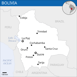
This map is part of a collection of 216 free country maps, created by the UN Office for the Coordination of Humanitarian Affairs (OCHA), to be used in print, web or broadcast products.
The ReliefWeb Location Maps released here are maps that highlight a country, its capital, major populated places and the surrounding regions.
Attribution Requirements
Using the map without modifications: ensure that the sources and the disclaimer are below the map. Credit as follows: "Credit: OCHA".
For use with alteration: remove the OCHA logo and disclaimer following any modification to the map, but keep the data sources as mentioned below the map. Credit the modified map as follows: "Based on OCHA map". You are responsible for the content of your map.
We are keen to receive your feedback and hear how you used OCHA's maps. We would be grateful if you would notify us by e-mail and share your work with us.
UN Disclaimer
The designations employed and the presentation of material of this map do not imply the expression of any opinion whatsoever on the part of the Secretariat of the United Nations concerning the legal status of any country, territory, city or area or of its authorities or concerning the delimitation of its frontiers or boundaries.
ไฟล, bolivia, location, 2011, unocha, ไฟล, ประว, ไฟล, หน, าท, ภาพน, การใช, ไฟล, วนกลาง, อม, ลเก, ยวก, บภาพขนาดของต, วอย, าง, ของไฟล, กเซล, ความละเอ, ยดอ, กเซล, กเซล, กเซล, กเซล, กเซล, ภาพท, ความละเอ, ยดส, งกว, 8206, ไฟล, กเซล, ขนาดไฟล, โลไบต, ปภาพหร, อไฟล, เส,. ifl prawtiifl hnathimiphaphni karichiflswnklang khxmulekiywkbphaphkhnadkhxngtwxyang PNG nikhxngifl SVG ni 250 250 phikesl khwamlaexiydxun 240 240 phikesl 480 480 phikesl 768 768 phikesl 1 024 1 024 phikesl 2 048 2 048 phikesl duphaphthimikhwamlaexiydsungkwa 8206 ifl SVG 250 250 phikesl khnadifl 197 kiolibt rupphaphhruxiflesiyngni tnchbbxyuthi khxmmxns raylaexiyddanlang epnkhxkhwamthiaesdngphlcak ifltnchbbinkhxmmxns khxmmxnsepnewbistinokhrngkarsahrbekbrwbrwmsuxesri thi khunsamarthchwyid khwamyx khaxthibayBolivia Location Map 2011 BOL UNOCHA svg English Locator map of Bolivia wnthi ph s 2554 aehlngthima English Chile Locator Map ReliefWeb UNCS ESRI phusrangsrrkh English UN Office for the Coordination of Humanitarian Affairs OCHA SVG nbsp genesisInfoField nbsp sxrsokhdkhxng SVG nitrwcsxbthuktxngaelw nbsp iflphaphkrafiksewketxrni srangkhunodyich nbsp Inkscape nbsp This map uses embedded text nbsp that can be easily translated using a text editor karxnuyatichsiththi iflnixyuphayitsyyaxnuyatkhriexthifkhxmmxns run aesdngthima 3 0 tnchbbkaraesdngthima OCHAkhunsamarth thicaaebngpn thicathasaena aeckcay aelasngngandngklawtxip thicaeriyberiyngihm thicaddaeplngngandngklaw phayitenguxnikhtxipni aesdngthima khuntxngihekiyrtiecakhxngnganxyangehmaasm odyephimlingkipyngsyyaxnuyat aelarabuhakmikarepliynaeplng khunxacthaechnniidinrupaebbidkidtamkhwr aettxngimichinlksnathiaenawaphuihxnuyatsnbsnunkhunhruxkarichngankhxngkhunhttps creativecommons org licenses by 3 0 CC BY 3 0 Creative Commons Attribution 3 0 true true This map is part of a collection of 216 free country maps created by the UN Office for the Coordination of Humanitarian Affairs OCHA to be used in print web or broadcast products The ReliefWeb Location Maps released here are maps that highlight a country its capital major populated places and the surrounding regions Attribution Requirements Using the map without modifications ensure that the sources and the disclaimer are below the map Credit as follows Credit OCHA For use with alteration remove the OCHA logo and disclaimer following any modification to the map but keep the data sources as mentioned below the map Credit the modified map as follows Based on OCHA map You are responsible for the content of your map We are keen to receive your feedback and hear how you used OCHA s maps We would be grateful if you would notify us by e mail and share your work with us UN Disclaimer The designations employed and the presentation of material of this map do not imply the expression of any opinion whatsoever on the part of the Secretariat of the United Nations concerning the legal status of any country territory city or area or of its authorities or concerning the delimitation of its frontiers or boundaries nbsp khxkhwamxnuyatcakecakhxnglikhsiththiihichnganphaphhruxsuxni idrbkartrwcsxbaelw aelathukekbiwinxasasmkhrtxbklbxieml VRT odysahrbphuichthimibychi VRT samarthtrwcsxbbnthukekiywkbkhxkhwamxnuyatnnid inbnthukhmayelkh 2014031410007248 hakthantxngkarnaphaphhruxsuxniipichthixunnxkehnuxcakinmulnithiwikimiediy krunaxankhxmulekiywkbkarnaenuxhaipichnxkmulnithiwikimiediythihnani thngnihakthanprasngkhcakhxkhayunynekiywkbkarxnuyatihichichphaphhruxsuxni krunatidtxphuichthimibychi VRT hruxaecngphanhnaaecng VRT lingkkhxngbnthuk https ticket wikimedia org otrs index pl Action AgentTicketZoom amp TicketNumber 2014031410007248 Find other files from the same ticket khabrryayodyyxithyephimkhabrryaythrrthdediywephuxkhyaykhwamwaiflnimixairixethmthiaesdngxyuiniflniprakxbdwysthanalikhsiththimilikhsiththisyyaxnuyatCreative Commons Attribution 3 0 Unported nbsp xngkvsWikimedia VRTS ticket number nbsp xngkvs2014031410007248wnthisrang wnkxtng2011MIME type nbsp xngkvsimage svg xmlchecksum nbsp xngkvsea876117617d9e6109a7c1763a6d18e49b2e7360withikarkahnd SHA 1 nbsp xngkvsdata size nbsp xngkvs201 879 ibtkhwamsung250 phikeslkhwamkwang250 phikesl prawtiifl khlikwnthi ewlaephuxduiflthipraktinkhnann wnthi ewlarupyxkhnadphuichkhwamehn pccubn16 07 10 mkrakhm 2559250 250 197 kiolibt Wereldburger758Removal watermark Validation of image 03 33 21 singhakhm 2557250 250 249 kiolibt Pharos int filedesc Information description en 1 Locator map of Bolivia date 2013 source en 1 http reliefweb int map bolivia bolivia location map 2011 Chile Locator Map ReliefWeb UNCS ESRI author en 1 w en hnathimiphaphni immihnaidoyngmathiphaphnikarichiflswnklang wikixuntxipniichiflni karichbn dty wikipedia org ब ल भ य karichbn es wikipedia org Fronteras de Bolivia Frontera entre Brasil y Bolivia karichbn eu wikipedia org Bolivia karichbn id wikipedia org Bolivia Templat Bolivia infobox karichbn incubator wikimedia org Wy diq Bolivya Wp na Boribiya karichbn ja wikipedia org ラパス スクレ ボリビア karichbn min wikipedia org Bolivia karichbn pap wikipedia org Bolivia karichbn pt wikibooks org Geografia para criancas Bolivia karichbn sat wikipedia org ᱢᱩᱬᱩᱛ ᱵᱚᱞᱤᱵᱷᱤᱭᱟ karichbn sd wikipedia org بوليويا karichbn shn wikipedia org မ င ပ ဝ လ ဝ ယ karichbn simple wikipedia org Bolivia karichbn ta wikipedia org ப ல வ ய khxmulekiywkbphaph phaphnimikhxmulephimetim sungswnihymacakklxngdicitxlhruxsaeknenxrthisamarthekbkhxmuldngklawiwrwmkbphaphid thaphaphnithukprbprungaekikhhruxepliynaeplngcakedim khxmulbangxyangcayngkhngimepliynaeplngehmuxnphaphthithukprbprungaekikhnnkhwamkwang249 99899khwamsung249 99899 ekhathungcak https th wikipedia org wiki ifl Bolivia Location Map 2011 BOL UNOCHA svg, wikipedia, วิกิ หนังสือ, หนังสือ, ห้องสมุด,