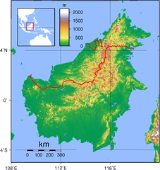
English: Relief (hypsometric) map of Borneo. Red lines represent national borders between Indonesia (south), Malaysia (north), and Brunei (top north). Created with GMT from publicly released GLOBE data[1]. For locator version, see File:Borneo Locator Topography.png.
Français : Carte du relief de l'île de Borneo. Les lignes rouges représentent les frontières séparant les états se partageant l'île de Bornéo : L'Indonésie (au sud), la Malaisie (au nord de l'Indonésie) et l'état de Bruneï (au nord de la Malaisie). Image produite à l'aide de la suite logicielle GMT à partir des données publiques GLOBE. Une version locator est disponible.
{{Information |Description=Topographical map of Borneo. Created with GMT from publicly released GLOBE data[http://www.ngdc.noaa.gov/mgg/topo/globe.html]. |Source=self-made |Date=June 3, 2007 |Author= User:Sadalmelik }} Category:Maps of Malaysia
ไฟล, borneo, topography, ไฟล, ประว, ไฟล, หน, าท, ภาพน, การใช, ไฟล, วนกลางขนาดของต, วอย, างน, กเซล, ความละเอ, ยดอ, กเซล, กเซล, กเซล, กเซล, กเซล, ภาพท, ความละเอ, ยดส, งกว, 8206, กเซล, ขนาดไฟล, เมกะไบต, ชน, ดไมม, image, ปภาพหร, อไฟล, เส, ยงน, นฉบ, บอย, คอมมอนส, ร. ifl prawtiifl hnathimiphaphni karichiflswnklangkhnadkhxngtwxyangni 567 600 phikesl khwamlaexiydxun 227 240 phikesl 454 480 phikesl 726 768 phikesl 968 1 024 phikesl 1 725 1 824 phikesl duphaphthimikhwamlaexiydsungkwa 8206 1 725 1 824 phikesl khnadifl 2 52 emkaibt chnidimm image png rupphaphhruxiflesiyngni tnchbbxyuthi khxmmxns raylaexiyddanlang epnkhxkhwamthiaesdngphlcak ifltnchbbinkhxmmxns khxmmxnsepnewbistinokhrngkarsahrbekbrwbrwmsuxesri thi khunsamarthchwyid khwamyx khaxthibayBorneo Topography png English Relief hypsometric map of Borneo Red lines represent national borders between Indonesia south Malaysia north and Brunei top north Created with GMT from publicly released GLOBE data 1 For locator version see File Borneo Locator Topography png Francais Carte du relief de l ile de Borneo Les lignes rouges representent les frontieres separant les etats se partageant l ile de Borneo L Indonesie au sud la Malaisie au nord de l Indonesie et l etat de Brunei au nord de la Malaisie Image produite a l aide de la suite logicielle GMT a partir des donnees publiques GLOBE Une version locator est disponible wnthi 3 mithunayn ph s 2550aehlngthima ngankhxngtwphusrangsrrkh Sadalmelik phaphxnthrngkhunkhaphaphniidrbkarpraeminphayit eknthphaphxnthrngkhunkha aelathuxwaepn phaphxnthrngkhunkhathisudinkhxmmxns phayitkhxbekht Hypsometric map of Borneo khunsamarthdukaresnxchuxid thini karxnuyatichsiththi Public domain Public domain false falsekhapheca phuthuxlikhsiththiinnganni khxmxbnganihepnsatharnsmbti prakasnimiphlthwolkinbangpraeths karkrathadngklawxacimsamarththaidtamkdhmaykhaphecaxnuyatihthukkhnmisiththiinkarichiflniinthukehtuphlkarich odyimmimienguxnikh ewnaetkdhmayimxnuyatihthaechnnnkhabrryayodyyxithyephimkhabrryaythrrthdediywephuxkhyaykhwamwaiflnimixairixethmthiaesdngxyuiniflniprakxbdwyphusrangbangkhathiimmiixethmwikisnethschuxphuichwikimiediy Sadalmelikyuxaraexl https commons wikimedia org wiki user Sadalmelikchuxphusrangsrrkh Sadalmeliksthanalikhsiththicopyrighted dedicated to the public domain by copyright holder xngkvssyyaxnuyatreleased into the public domain by the copyright holder xngkvsCommons quality assessment xngkvsWikimedia Commons valued image xngkvsewlaerim 7 phvsphakhm 2010wnthisrang wnkxtng3 mithunayn 2007thimakhxngiflkarsrangdngedimodyphuxpohld prawtiifl khlikwnthi ewlaephuxduiflthipraktinkhnann wnthi ewlarupyxkhnadphuichkhwamehn pccubn02 17 2 knyayn 25501 725 1 824 2 52 emkaibt SadalmelikBetter data better colours 03 54 4 mithunayn 25502 083 2 158 1 67 emkaibt Sadalmelik Information Description Topographical map of Borneo Created with GMT from publicly released GLOBE data http www ngdc noaa gov mgg topo globe html Source self made Date June 3 2007 Author User Sadalmelik Category Maps of Malaysia hnathimiphaphni hnatxipni oyngmathiphaphni ekaabxreniyw karichiflswnklang wikixuntxipniichiflni karichbn af wikipedia org Borneo karichbn ar wikipedia org الخطوط العريضة لماليزيا karichbn az wikipedia org Kalimantan karichbn ban wikipedia org Nusa Kalimantan karichbn be tarask wikipedia org Kalimantan karichbn be wikipedia org Kalimantan karichbn bg wikipedia org Borneo karichbn bn wikipedia org ব র ন ও karichbn ca wikipedia org Hyalobagrus leiacanthus karichbn ceb wikipedia org Borneo Hyalobagrus leiacanthus karichbn de wikipedia org Borneo Batang Ai National Park karichbn de wikivoyage org Borneo karichbn de wiktionary org Borneo karichbn el wikipedia org Borneo karichbn el wiktionary org Borneo karichbn en wikipedia org Borneo East Malaysia Talk Borneo List of endemic birds of Borneo Outline of Malaysia User Chickstarr404 Gather lists 13386 A Travelers Alphabet by Stephen Runciman Wikipedia Today s featured list June 2021 Wikipedia Today s featured list June 11 2021 Wikipedia Main Page history 2021 June 11 Wikipedia Main Page history 2021 June 11b Phalaenopsis kapuasensis Phalaenopsis luteola Phalaenopsis modesta Phalaenopsis pantherina Phalaenopsis singuliflora User AryKun Misc Naval Base Borneo karichbn en wikibooks org Professionalism Michael de Guzman and the Bre X Scandal karichbn en wikinews org Category Borneo karichbn eo wikipedia org Borneo karichbn es wikipedia org Rio Kapuas Rio Mahakam karichbn et wikipedia org Kalimantan karichbn eu wikipedia org Hyalobagrus leiacanthus karichbn fa wikipedia org بورنئو karichbn fi wikipedia org Borneo karichbn fo wikipedia org Borneo karichbn frr wikipedia org Borneo karichbn fr wikipedia org Projet Charte graphique Domaine geographique Modele Infobox Ile Documentation Modele Infobox Ile Borneo karichbn gl wikipedia org Rio Kapuas dukarichthwolkephimetimkhxngiflni ekhathungcak https th wikipedia org wiki ifl Borneo Topography png, wikipedia, วิกิ หนังสือ, หนังสือ, ห้องสมุด,