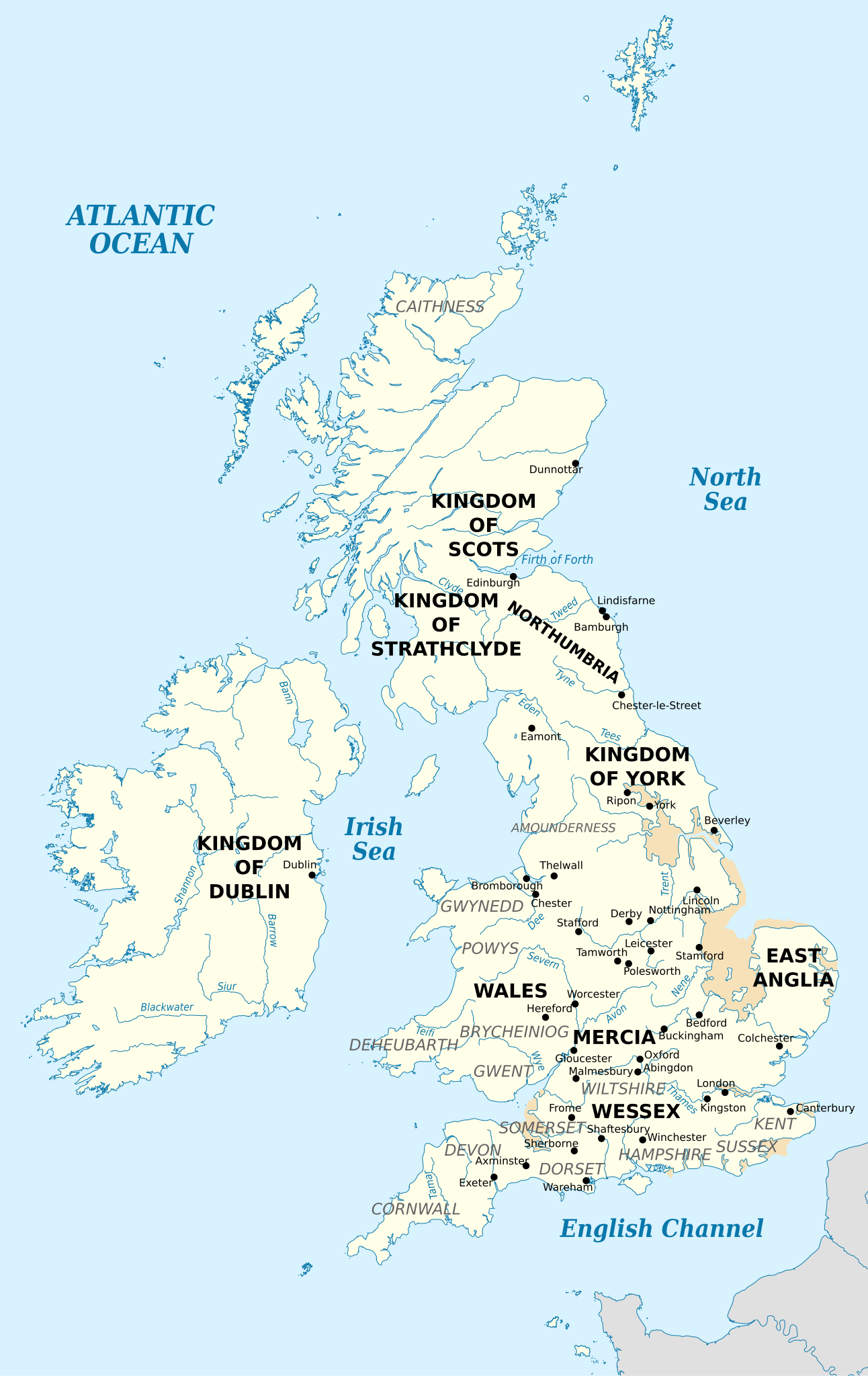
English: British Isles in 10th century represented with the coastline at the time.
Sea Land at the time
Swamp or alluvium
วันที่
แหล่งที่มา
Own work using:
Map 1 in Sarah Foot's Æthelstan: The First King of England, Yale University Press, 2011. Foot lists it on p. ix as "Britain in the Tenth Century, Richard Sowerby, after Paul Hill, The Age of Æthelstan (Stroud, 2004), map 1.
ไฟล, british, isles, 10th, century, ไฟล, ประว, ไฟล, หน, าท, ภาพน, การใช, ไฟล, วนกลาง, อม, ลเก, ยวก, บภาพขนาดของต, วอย, าง, ของไฟล, กเซล, ความละเอ, ยดอ, กเซล, กเซล, กเซล, กเซล, กเซล, กเซล, ภาพท, ความละเอ, ยดส, งกว, 8206, ไฟล, กเซล, ขนาดไฟล, เมกะไบต, ปภาพหร, อไฟ. ifl prawtiifl hnathimiphaphni karichiflswnklang khxmulekiywkbphaphkhnadkhxngtwxyang PNG nikhxngifl SVG ni 378 599 phikesl khwamlaexiydxun 151 240 phikesl 303 480 phikesl 484 768 phikesl 646 1 024 phikesl 1 292 2 048 phikesl 990 1 569 phikesl duphaphthimikhwamlaexiydsungkwa 8206 ifl SVG 990 1 569 phikesl khnadifl 1 78 emkaibt rupphaphhruxiflesiyngni tnchbbxyuthi khxmmxns raylaexiyddanlang epnkhxkhwamthiaesdngphlcak ifltnchbbinkhxmmxns khxmmxnsepnewbistinokhrngkarsahrbekbrwbrwmsuxesri thi khunsamarthchwyid khwamyx khaxthibayBritish Isles 10th century svg English British Isles in 10th century represented with the coastline at the time Sea Land at the time Swamp or alluviumwnthi 31 singhakhm ph s 2556 19 52 35aehlngthima Own work using Map 1 in Sarah Foot s AEthelstan The First King of England Yale University Press 2011 Foot lists it on p ix as Britain in the Tenth Century Richard Sowerby after Paul Hill The Age of AEthelstan Stroud 2004 map 1 Bristish islands blank svg For the coastline at the timephusrangsrrkh Ikonact karxnuyatichsiththi iflnixyuphayitsyyaxnuyat khriexthifkhxmmxns aebbaesdngthima xnuyataebbediywkn 3 0 tnchbbkhunsamarth thicaaebngpn thicathasaena aeckcay aelasngngandngklawtxip thicaeriyberiyngihm thicaddaeplngngandngklaw phayitenguxnikhtxipni aesdngthima khuntxngihekiyrtiecakhxngnganxyangehmaasm odyephimlingkipyngsyyaxnuyat aelarabuhakmikarepliynaeplng khunxacthaechnniidinrupaebbidkidtamkhwr aettxngimichinlksnathiaenawaphuihxnuyatsnbsnunkhunhruxkarichngankhxngkhun xnuyataebbediywkn hakkhunddaeplng epliynrup hruxtxetimnganni khuntxngichsyyaxnuyataebbediywknhruxaebbthiehmuxnkbsyyaxnuyatthiichkbnganniethannhttps creativecommons org licenses by sa 3 0 CC BY SA 3 0 Creative Commons Attribution Share Alike 3 0 true truekhabrryayodyyxithyephimkhabrryaythrrthdediywephuxkhyaykhwamwaiflnimixairxngkvsBritish Isles in 10th centuryrsesiyVelikobritaniya v desyatom vekuixethmthiaesdngxyuiniflniprakxbdwybritichixlsphusrangbangkhathiimmiixethmwikisnethschuxphuichwikimiediy Ikonactchuxphusrangsrrkh Ikonactyuxaraexl https commons wikimedia org wiki user IkonactsthanalikhsiththimilikhsiththisyyaxnuyatCreative Commons Attribution ShareAlike 3 0 Unported xngkvswnthisrang wnkxtng31 singhakhm 2013MIME type xngkvsimage svg xml prawtiifl khlikwnthi ewlaephuxduiflthipraktinkhnann wnthi ewlarupyxkhnadphuichkhwamehn pccubn07 13 13 krkdakhm 2561990 1 569 1 78 emkaibt KashmiriCorrected location of London and Kingston relative to Thames 03 40 5 knyayn 2556990 1 569 1 78 emkaibt Ikonactfile size optimisation 04 00 3 knyayn 2556990 1 569 4 31 emkaibt Ikonactnow with old coastline 21 40 1 knyayn 2556990 1 569 2 55 emkaibt Ikonactsome names in grey to improve visibility 03 57 1 knyayn 2556990 1 569 2 54 emkaibt Ikonactupdates of the places rivers names 00 57 1 knyayn 2556990 1 569 2 53 emkaibt IkonactUser created page with UploadWizard hnathimiphaphni hnatxipni oyngmathiphaphni karkbtkhxngexethlwald karichiflswnklang wikixuntxipniichiflni karichbn az wikipedia org I Edmund karichbn el wikipedia org E8elstan ths Agglias karichbn en wikipedia org Edmund I 10th century Eadred AEthelstan Sitric Caech AEthelwold s Revolt Wikipedia Graphics Lab Map workshop Archive Sep 2013 Wikipedia Graphics Lab Map workshop Archive Jul 2015 karichbn hu wikipedia org Szerkeszto Pali1977 Eadred karichbn it wikipedia org Atelstano d Inghilterra karichbn no wikipedia org Adalstein av England karichbn ru wikipedia org Vosstanie Etelvolda karichbn simple wikipedia org Athelstan karichbn www wikidata org Q8077397khxmulekiywkbphaph phaphnimikhxmulephimetim sungswnihymacakklxngdicitxlhruxsaeknenxrthisamarthekbkhxmuldngklawiwrwmkbphaphid thaphaphnithukprbprungaekikhhruxepliynaeplngcakedim khxmulbangxyangcayngkhngimepliynaeplngehmuxnphaphthithukprbprungaekikhnnkhwamkwang990khwamsung1569 ekhathungcak https th wikipedia org wiki ifl British Isles 10th century svg, wikipedia, วิกิ หนังสือ, หนังสือ, ห้องสมุด,