This vector image includes elements that have been taken or adapted from this file:
Aruba in the Kingdom of the Netherlands.svg (โดย TUBS).
ผู้สร้างสรรค์
TUBS
เวอร์ชันอื่น
This SVG map is part of a locator map series applying the widespread location map scheme. Please see root category to browse for more.
More ▼
ทวีปแอฟริกา
Algeria • Angola • Benin • Botswana • Burkina Faso • Burundi • Cameroon • Cape Verde • Central African Republic • Chad • Comoros • Côte d'Ivoire • Democratic Republic of the Congo • Republic of the Congo • Djibouti • Egypt • Equatorial Guinea • Eritrea • Eswatini • Ethiopia • Gabon • Gambia • Ghana • Guinea-Bissau • Guinea • Kenya • Lesotho • Liberia • Libya • Madagascar • Malawi • Mali • Mauritania • Mauritius • Morocco • Mozambique • Namibia • Niger • Nigeria • Rwanda • (Sahrawi Arab Democratic Republic) • Senegal • Seychelles • Sierre Leone • Somalia • Somaliland • South Africa • South Sudan • Sudan • São Tomé and Príncipe • Tanzania • Togo • Tunisia • Uganda • Yemen • Zambia • Zimbabwe
ทวีปเอเชีย
(Abkhazia) • Afghanistan • Armenia • Azerbaijan • Bahrain • Bangladesh • Bhutan • Brunei • Cambodia • China • Republic of China • Cyprus • East Timor • Egypt • Georgia • India • Indonesia • Iran • Iraq • Israel • Japan • Jordan • Kazakhstan • Kuwait • Kyrgyzstan • Laos • Lebanon • Malaysia • Maldives • Mongolia • Myanmar • Nepal • North Korea • (Northern Cyprus) • Oman • Pakistan • (Palestine) • Papua New Guinea • Philippines • Qatar • Russia • Saudi Arabia • Singapore • South Korea • (South Ossetia) • Sri Lanka • Syria • Tajikistan • Thailand • Turkey • Turkmenistan • United Arab Emirates • Uzbekistan • Vietnam • Yemen
ทวีปยุโรป
(European Union) • (Abkhazia) • Albania • Andorra • Armenia • Austria • Azerbaijan • Belarus • Belgium • Bosnia and Herzegovina • Bulgaria • Czech Republic • Croatia • Cyprus • Denmark • Estonia • Finland • France • Georgia • Germany • Greece • (Guernsey) • Hungary • Iceland • Ireland • Italy • (Jersey) • Kazakhstan • (Kosovo) • Latvia • Liechtenstein • Lithuania • Luxembourg • Malta • (Isle of Man) • Moldova • Monaco • Montenegro • Netherlands • North Macedonia • (Northern Cyprus) • Norway • Poland • Portugal • Romania • Russia • San Marino • Serbia • Slovakia • Slovenia • (South Ossetia) • Spain • Sweden • Switzerland • Turkey • Ukraine • United Kingdom • Vatican City
ทวีปอเมริกาเหนือ
Antigua and Barbuda • Bahamas • Barbados • Belize • Canada • Costa Rica • Cuba • Dominica • Dominican Republic • El Salvador • Grenada • Guatemala • Haiti • Honduras • Iceland • Jamaica • Mexico • Nicaragua • Panama • Saint Kitts and Nevis • Saint Lucia • Saint Vincent and the Grenadines • Trinidad and Tobago • United States
โอเชียเนีย
Australia • (Cook Islands) • Fiji • Indonesia • Kiribati • Marshall Islands • Micronesia • Nauru • New Zealand • (Niue) • Palau • Papua New Guinea • Samoa • Solomon Islands • Tonga • Tuvalu • Vanuatu
ทวีปอเมริกาใต้
Argentina • Bolivia • Brazil • Chile • Colombia • Ecuador • Guyana • Panama • Paraguay • Peru • Suriname • Trinidad and Tobago • Uruguay • Venezuela
ทวีปแอนตาร์กติกา
-
Locator maps design recommendations ▼
Principles
Design Guidelines are based on ▸location map design of the German map shop (in German). It's preferable to derive new locator maps from existing location maps. Please keep both size and ratio in this case. Thus the new locator maps may still be applied as location map (▸Guide). Marker color is supposed to be darkred. Waterbodies may be transparent, to show other objects better. Please be aware that this guide is only a recommendation. It’s not an inevitable law!
Color template
Template toolbox
Other optional map elements
Subdivision of a country
Country within an international organization
Country without context projected on the globe
Country without context
Highlight small areas
Marker
Merged markers
“Glowing” edges
Zoom
Zoom
Zoom
“Remote” areas and mini maps
Mini maps show where the depicted area actually is situated. Check out ▸Vorlage:Positionskarte+ (in German) and ▸Modèle:Carte en coin (in French) of how to insert a mini map in virtually every map.
Small maps apply different scales
Small map applies same scale as main map
Mini map with box
Depicted continent dark grey
Zoomed box on a world map also showing the remote part of country
Disputed areas
rest of Serbia: foreign or the same country?
Kosovo: part of Serbia?
Whether South Ossetia or Abkhazia form a part of Georgia is disputed. The marked Georgian administrative region however is partly under Georgian control (solid red) while other parts are part break-away "country" South Ossetia (hatched).
India claims some northern areas (hatched) while other areas are controlled by India but challenged by other countries. India claims all of Kashmir (red areas), while it controls only the southern part of it (cf. broad red stripes vs. narrow red stripes).
Western Sahara: part of Morocco?
Like above. However, the map differentiates whether the disputed area is controlled by Morocco or not.
Locator map of Taiwan in China. Map hatches all areas that are claimed but not controlled by China. Hence, highlighted Taiwan is also hatched grey/red.
Greyed special objects
Glaciers
Urbanized areas
Backgrounds
Relief
Relief (like before, but outlines highlighted)
Satellite view
Land cover
Relief
Corresponding imagemaps ▼
ทวีปแอฟริกา
Algeria • Angola • Benin • Botswana • Burkina Faso • Burundi • Cameroon • Cape Verde • Central African Republic • Chad • Comoros • Côte d'Ivoire • Democratic Republic of the Congo • Repbulic of the Congo • Djibouti • Egypt • Equatorial Guinea • Eritrea • Ethiopia • Gabon • Gambia • Ghana • Guinea-Bissau • Guinea • Kenya • Lesotho • Liberia • Libya • Madagascar • Malawi • Mali • Mauritania • Mauritius • Morocco • Mozambique • Namibia • Niger • Nigeria • Rwanda • (Sahrawi Arab Democratic Republic) • Senegal • Seychelles • Sierre Leone • Somalia • South Africa • South Sudan • Sudan • Swaziland • São Tomé and Príncipe • Tanzania • Togo • Tunisia • Uganda • Yemen • Zambia • Zimbabwe
ทวีปเอเชีย
(Abkhazia) • Afghanistan • Armenia • Azerbaijan • Bahrain • Bangladesh • Bhutan • Brunei • Cambodia • China• Republic of China • Cyprus • East Timor • Egypt • Georgia • India • Indonesia • Iran • Iraq • Israel • Japan • Jordan • Kazakhstan • Kuwait • Kyrgyzstan • Laos • Lebanon • Malaysia • Maldives • Mongolia • Myanmar • Nepal • North Korea • (Northern Cyprus) • Oman • Pakistan • (Palestine) • Papua New Guinea• Philippines • Qatar • Russia • Saudi Arabia • Singapore • South Korea • (South Ossetia) • Sri Lanka • Syria • Tajikistan • Thailand • Turkey • Turkmenistan• United Arab Emirates • Uzbekistan • Vietnam • Yemen
ทวีปยุโรป
(Abkhazia) • Albania • Andorra • Armenia • Austria • Azerbaijan • Belarus • Belgium • Bosnia and Herzegovina • Bulgaria • Czech Republic • Croatia • Cyprus • Denmark • Estonia • Finland • France • Georgia • Germany • Greece • (Guernsey) • Hungary • Iceland • Ireland • Italy • (Jersey) • Kazakhstan • (Kosovo) • Latvia • Liechtenstein • Lithuania • Luxembourg • Macedonia • Malta • (Isle of Man) • Moldova • Monaco • Montenegro • Netherlands • (Northern Cyprus) • Norway • Poland • Portugal • Romania • Russia • San Marino • Serbia • Slovakia • Slovenia • (South Ossetia) • Spain • Sweden • Switzerland • Turkey • Ukraine • United Kingdom • Vatican City
ทวีปอเมริกาเหนือ
Antigua and Barbuda • Bahamas • Barbados • Belize • Canada • Costa Rica • Cuba • Dominica • Dominican Republic • El Salvador • Grenada • Guatemala • Haiti • Honduras • Iceland • Jamaica • Mexico • Nicaragua • Panama • Saint Kitts and Nevis • Saint Lucia • Saint Vincent and the Grenadines • Trinidad and Tobago • United States
โอเชียเนีย
Australia • Brunei • (Cook Islands) • East Timor • Fiji • Indonesia • Kiribati • Marshall Islands • Micronesia • Nauru • New Zealand • (Niue) • Palau • Papua New Guinea • Samoa • Solomon Islands • Tonga • Tuvalu • Vanuatu
ทวีปอเมริกาใต้
Argentina • Bolivia • Brazil • Chile • Colombia • Ecuador • Guyana • Panama • Paraguay • Peru • Suriname • Trinidad and Tobago • Uruguay • Venezuela
I'd greatly appreciate, that you attribute this media file to Wikimedia Commons, if used outside Wikipedia or Commons. For use in publications such as books, newspapers, blogs, websites, please insert here the following line:
{{published|author= |date= |url= |title= |org= }}
and fill the applicable fields. (Example). License terms given above still apply.
বাংলা ∙ Deutsch ∙ Deutsch (Sie-Form) ∙ Ελληνικά ∙ English ∙ español ∙ français ∙ Ἀρχαία ἑλληνικὴ ∙ Bahasa Indonesia ∙ 日本語 ∙ македонски ∙ Nederlands ∙ português ∙ русский ∙ Türkçe ∙ 简体中文 ∙ 繁體中文 ∙ +/−
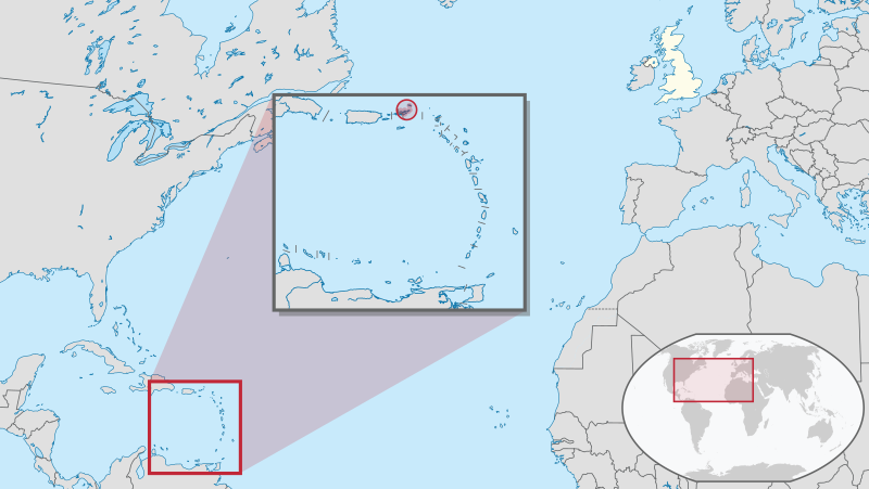
{{Information |Description={{de|Lage des Überseegebietes XY (siehe Dateiname) im Vereinigten Königreich.}} {{en|Location of overseas territory xy (see filename) in the United Kingdom.}} |Source={{o
Коронавірусна хвороба 2019 на Британських Віргінських Островах
Список птахів Британських Віргінських Островів
英屬維爾京群島
มิถุนายน 29, 2023
ไฟล, british, virgin, islands, united, kingdom, ไฟล, ประว, ไฟล, หน, าท, ภาพน, การใช, ไฟล, วนกลางขนาดของต, วอย, าง, ของไฟล, กเซล, ความละเอ, ยดอ, กเซล, กเซล, กเซล, กเซล, กเซล, กเซล, ภาพท, ความละเอ, ยดส, งกว, 8206, ไฟล, กเซล, ขนาดไฟล, เมกะไบต, ปภาพหร, อไฟล, เส, ย. ifl prawtiifl hnathimiphaphni karichiflswnklangkhnadkhxngtwxyang PNG nikhxngifl SVG ni 800 451 phikesl khwamlaexiydxun 320 180 phikesl 640 360 phikesl 1 024 577 phikesl 1 280 721 phikesl 2 560 1 442 phikesl 1 021 575 phikesl duphaphthimikhwamlaexiydsungkwa 8206 ifl SVG 1 021 575 phikesl khnadifl 7 22 emkaibt rupphaphhruxiflesiyngni tnchbbxyuthi khxmmxns raylaexiyddanlang epnkhxkhwamthiaesdngphlcak ifltnchbbinkhxmmxns khxmmxnsepnewbistinokhrngkarsahrbekbrwbrwmsuxesri thi khunsamarthchwyid khwamyx khaxthibayBritish Virgin Islands in United Kingdom svg Deutsch Lage des Uberseegebietes XY siehe Dateiname im Vereinigten Konigreich English Location of overseas territory xy see filename in the United Kingdom wnthi 5 singhakhm ph s 2554 aehlngthima ngankhxngtw nbsp iflphaphkrafiksewketxrimidrabukartrwcody W3C nbsp ni srangkhunodyich nbsp Adobe Illustrator nbsp This SVG file was uploaded with Commonist nbsp This vector image includes elements that have been taken or adapted from this file Aruba in the Kingdom of the Netherlands svg ody nbsp TUBS phusrangsrrkh TUBS ewxrchnxun This SVG map is part of a locator map series applying the widespread location map scheme Please see root category to browse for more More thwipaexfrikaAlgeria Angola Benin Botswana Burkina Faso Burundi Cameroon Cape Verde Central African Republic Chad Comoros Cote d Ivoire Democratic Republic of the Congo Republic of the Congo Djibouti Egypt Equatorial Guinea Eritrea Eswatini Ethiopia Gabon Gambia Ghana Guinea Bissau Guinea Kenya Lesotho Liberia Libya Madagascar Malawi Mali Mauritania Mauritius Morocco Mozambique Namibia Niger Nigeria Rwanda Sahrawi Arab Democratic Republic Senegal Seychelles Sierre Leone Somalia Somaliland South Africa South Sudan Sudan Sao Tome and Principe Tanzania Togo Tunisia Uganda Yemen Zambia Zimbabwethwipexechiy Abkhazia Afghanistan Armenia Azerbaijan Bahrain Bangladesh Bhutan Brunei Cambodia China Republic of China Cyprus East Timor Egypt Georgia India Indonesia Iran Iraq Israel Japan Jordan Kazakhstan Kuwait Kyrgyzstan Laos Lebanon Malaysia Maldives Mongolia Myanmar Nepal North Korea Northern Cyprus Oman Pakistan Palestine Papua New Guinea Philippines Qatar Russia Saudi Arabia Singapore South Korea South Ossetia Sri Lanka Syria Tajikistan Thailand Turkey Turkmenistan United Arab Emirates Uzbekistan Vietnam Yementhwipyuorp European Union Abkhazia Albania Andorra Armenia Austria Azerbaijan Belarus Belgium Bosnia and Herzegovina Bulgaria Czech Republic Croatia Cyprus Denmark Estonia Finland France Georgia Germany Greece Guernsey Hungary Iceland Ireland Italy Jersey Kazakhstan Kosovo Latvia Liechtenstein Lithuania Luxembourg Malta Isle of Man Moldova Monaco Montenegro Netherlands North Macedonia Northern Cyprus Norway Poland Portugal Romania Russia San Marino Serbia Slovakia Slovenia South Ossetia Spain Sweden Switzerland Turkey Ukraine United Kingdom Vatican CitythwipxemrikaehnuxAntigua and Barbuda Bahamas Barbados Belize Canada Costa Rica Cuba Dominica Dominican Republic El Salvador Grenada Guatemala Haiti Honduras Iceland Jamaica Mexico Nicaragua Panama Saint Kitts and Nevis Saint Lucia Saint Vincent and the Grenadines Trinidad and Tobago United StatesoxechiyeniyAustralia Cook Islands Fiji Indonesia Kiribati Marshall Islands Micronesia Nauru New Zealand Niue Palau Papua New Guinea Samoa Solomon Islands Tonga Tuvalu VanuatuthwipxemrikaitArgentina Bolivia Brazil Chile Colombia Ecuador Guyana Panama Paraguay Peru Suriname Trinidad and Tobago Uruguay Venezuelathwipaexntarktika Locator maps design recommendations Principles Design Guidelines are based on location map design of the German map shop in German It s preferable to derive new locator maps from existing location maps Please keep both size and ratio in this case Thus the new locator maps may still be applied as location map Guide Marker color is supposed to be darkred Waterbodies may be transparent to show other objects better Please be aware that this guide is only a recommendation It s not an inevitable law Color template Template toolbox Other optional map elements Subdivision of a country Country within an international organization Country without context projected on the globe Country without context Highlight small areas Marker Merged markers Glowing edges Zoom Zoom Zoom Remote areas and mini maps Mini maps show where the depicted area actually is situated Check out Vorlage Positionskarte in German and Modele Carte en coin in French of how to insert a mini map in virtually every map Small maps apply different scales Small map applies same scale as main map Mini map with box Depicted continent dark grey Zoomed box on a world map also showing the remote part of country Disputed areas rest of Serbia foreign or the same country Kosovo part of Serbia Whether South Ossetia or Abkhazia form a part of Georgia is disputed The marked Georgian administrative region however is partly under Georgian control solid red while other parts are part break away country South Ossetia hatched India claims some northern areas hatched while other areas are controlled by India but challenged by other countries India claims all of Kashmir red areas while it controls only the southern part of it cf broad red stripes vs narrow red stripes Western Sahara part of Morocco Like above However the map differentiates whether the disputed area is controlled by Morocco or not Locator map of Taiwan in China Map hatches all areas that are claimed but not controlled by China Hence highlighted Taiwan is also hatched grey red Greyed special objects Glaciers Urbanized areas Backgrounds Relief Relief like before but outlines highlighted Satellite view Land cover ReliefCorresponding imagemaps thwipaexfrikaAlgeria Angola Benin Botswana Burkina Faso Burundi Cameroon Cape Verde Central African Republic Chad Comoros Cote d Ivoire Democratic Republic of the Congo Repbulic of the Congo Djibouti Egypt Equatorial Guinea Eritrea Ethiopia Gabon Gambia Ghana Guinea Bissau Guinea Kenya Lesotho Liberia Libya Madagascar Malawi Mali Mauritania Mauritius Morocco Mozambique Namibia Niger Nigeria Rwanda Sahrawi Arab Democratic Republic Senegal Seychelles Sierre Leone Somalia South Africa South Sudan Sudan Swaziland Sao Tome and Principe Tanzania Togo Tunisia Uganda Yemen Zambia Zimbabwethwipexechiy Abkhazia Afghanistan Armenia Azerbaijan Bahrain Bangladesh Bhutan Brunei Cambodia China Republic of China Cyprus East Timor Egypt Georgia India Indonesia Iran Iraq Israel Japan Jordan Kazakhstan Kuwait Kyrgyzstan Laos Lebanon Malaysia Maldives Mongolia Myanmar Nepal North Korea Northern Cyprus Oman Pakistan Palestine Papua New Guinea Philippines Qatar Russia Saudi Arabia Singapore South Korea South Ossetia Sri Lanka Syria Tajikistan Thailand Turkey Turkmenistan United Arab Emirates Uzbekistan Vietnam Yementhwipyuorp Abkhazia Albania Andorra Armenia Austria Azerbaijan Belarus Belgium Bosnia and Herzegovina Bulgaria Czech Republic Croatia Cyprus Denmark Estonia Finland France Georgia Germany Greece Guernsey Hungary Iceland Ireland Italy Jersey Kazakhstan Kosovo Latvia Liechtenstein Lithuania Luxembourg Macedonia Malta Isle of Man Moldova Monaco Montenegro Netherlands Northern Cyprus Norway Poland Portugal Romania Russia San Marino Serbia Slovakia Slovenia South Ossetia Spain Sweden Switzerland Turkey Ukraine United Kingdom Vatican CitythwipxemrikaehnuxAntigua and Barbuda Bahamas Barbados Belize Canada Costa Rica Cuba Dominica Dominican Republic El Salvador Grenada Guatemala Haiti Honduras Iceland Jamaica Mexico Nicaragua Panama Saint Kitts and Nevis Saint Lucia Saint Vincent and the Grenadines Trinidad and Tobago United StatesoxechiyeniyAustralia Brunei Cook Islands East Timor Fiji Indonesia Kiribati Marshall Islands Micronesia Nauru New Zealand Niue Palau Papua New Guinea Samoa Solomon Islands Tonga Tuvalu VanuatuthwipxemrikaitArgentina Bolivia Brazil Chile Colombia Ecuador Guyana Panama Paraguay Peru Suriname Trinidad and Tobago Uruguay VenezuelaOtherthwipaexntarktika aephnthiolk lukolk karxnuyatichsiththi khapheca inthanaphuthuxlikhsiththikhxngphaphhruxsuxni xnuyatihichphaphhruxsuxniphayitenguxnikhtxipniiflnixyuphayitsyyaxnuyat khriexthifkhxmmxns aebbaesdngthima xnuyataebbediywkn 3 0 tnchbbkhunsamarth thicaaebngpn thicathasaena aeckcay aelasngngandngklawtxip thicaeriyberiyngihm thicaddaeplngngandngklaw phayitenguxnikhtxipni aesdngthima khuntxngihekiyrtiecakhxngnganxyangehmaasm odyephimlingkipyngsyyaxnuyat aelarabuhakmikarepliynaeplng khunxacthaechnniidinrupaebbidkidtamkhwr aettxngimichinlksnathiaenawaphuihxnuyatsnbsnunkhunhruxkarichngankhxngkhun xnuyataebbediywkn hakkhunddaeplng epliynrup hruxtxetimnganni khuntxngichsyyaxnuyataebbediywknhruxaebbthiehmuxnkbsyyaxnuyatthiichkbnganniethannhttps creativecommons org licenses by sa 3 0 CC BY SA 3 0 Creative Commons Attribution Share Alike 3 0 true true I d greatly appreciate that you attribute this media file to Wikimedia Commons if used outside Wikipedia or Commons For use in publications such as books newspapers blogs websites please insert here the following line published author date url title org and fill the applicable fields Example License terms given above still apply ব ল nbsp Deutsch nbsp Deutsch Sie Form nbsp Ellhnika nbsp English nbsp espanol nbsp francais nbsp Ἀrxaia ἑllhnikὴ nbsp Bahasa Indonesia nbsp 日本語 nbsp makedonski nbsp Nederlands nbsp portugues nbsp russkij nbsp Turkce nbsp 简体中文 nbsp 繁體中文 nbsp khabrryayodyyxithyephimkhabrryaythrrthdediywephuxkhyaykhwamwaiflnimixairixethmthiaesdngxyuiniflniprakxbdwyphusrangbangkhathiimmiixethmwikisnethschuxphusrangsrrkh TUBSchuxphuichwikimiediy TUBSyuxaraexl http commons wikimedia org wiki User TUBSsthanalikhsiththimilikhsiththisyyaxnuyatCreative Commons Attribution ShareAlike 3 0 Unported nbsp xngkvswnthisrang wnkxtng5 singhakhm 2011thimakhxngiflkarsrangdngedimodyphuxpohld prawtiifl khlikwnthi ewlaephuxduiflthipraktinkhnann wnthi ewlarupyxkhnadphuichkhwamehn pccubn20 03 5 singhakhm 25541 021 575 7 22 emkaibt TUBS Information Description de Lage des Uberseegebietes XY siehe Dateiname im Vereinigten Konigreich en Location of overseas territory xy see filename in the United Kingdom Source o hnathimiphaphni hnatxipni oyngmathiphaphni hmuekaabritichewxrcin karichiflswnklang wikixuntxipniichiflni karichbn am wikipedia org ብሪቲሽ ቭርጂን ደሴቶች karichbn azb wikipedia org بریتانیا ویرجین آدالاری karichbn cdo wikipedia org Ĭng guok liang Virgin Gung dō karichbn chr wikipedia org ᏈᏗᏍ ᏮᏥᏂ ᎤᎦᏚᏛ karichbn cs wikipedia org Britske Panenske ostrovy karichbn en wikipedia org COVID 19 pandemic in the British Virgin Islands karichbn eo wikipedia org ISO 3166 2 VG karichbn es wikipedia org Categoria Islas Virgenes Britanicas karichbn fi wikipedia org Brittilaiset Neitsytsaaret karichbn gl wikipedia org Illas Virxes Britanicas karichbn hak wikipedia org Yin koet liang Virgin Khiun to karichbn incubator wikimedia org Wp kjh Virgin Oltyryhtary Ilbek Britaniya karichbn io wikipedia org Virgin Insuli Britaniana karichbn ka wikipedia org ბრიტანეთის ვირჯინის კუნძულები ჩრდილოეთ ამერიკის ქვეყნების სია karichbn ko wikipedia org 영국령 버진아일랜드의 코로나19 범유행 karichbn ku wikipedia org Giraven Virjin en Britanyaye karichbn ml wikipedia org ബ ര ട ട ഷ വ ർജ ൻ ദ വ പ കൾ karichbn oc wikipedia org Illas Verges Britanicas Santa Elena Ascension e Tristan da Cunha karichbn or wikipedia org ବ ର ଟ ଶ ଭର ଜ ନ ଦ ୱ ପପ ଞ ଜ karichbn pa wikipedia org ਬਰਤ ਨਵ ਵਰਜ ਨ ਟ ਪ karichbn shn wikipedia org မ ၵ ၼ ဝ ၵ ၼ ၶ င ဢ င ၵလ တ karichbn simple wikipedia org British Virgin Islands karichbn smn wikipedia org Brittilas Nieidasuolluuh karichbn sr wikipedia org Britanska Devichanska Ostrva karichbn sv wikipedia org Brittiska Jungfruoarna karichbn tr wikipedia org Britanya Virjin Adalari karichbn uk wikipedia org Britanski Virginski Ostrovi Koronavirusna hvoroba 2019 na Britanskih Virginskih Ostrovah Spisok ptahiv Britanskih Virginskih Ostroviv karichbn ur wikipedia org برطانوی جزائر ورجن karichbn vi wikipedia org Quần đảo Virgin thuộc Anh karichbn xmf wikipedia org ბრიტანეთიშ ვირჯინიშ კოკეფი karichbn zh min nan wikipedia org Eng kok leng Virgin Kun to karichbn zh wikipedia org 英國海外領土 英屬維爾京群島 ekhathungcak https th wikipedia org wiki ifl British Virgin Islands in United Kingdom svg, wikipedia, วิกิ หนังสือ, หนังสือ, ห้องสมุด,