รูปภาพหรือไฟล์เสียงนี้ ต้นฉบับอยู่ที่ คอมมอนส์ รายละเอียดด้านล่าง เป็นข้อความที่แสดงผลจาก ไฟล์ต้นฉบับในคอมมอนส์ คอมมอนส์เป็นเว็บไซต์ในโครงการสำหรับเก็บรวบรวมสื่อเสรี ที่ คุณสามารถช่วยได้
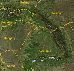
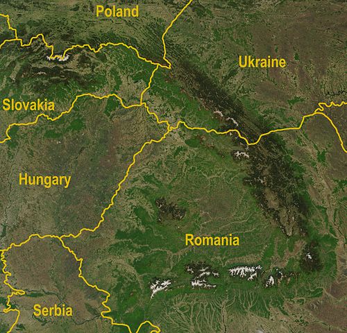
ความย่อ คำอธิบายCarpathians-satellite.jpg A satellite map of the Carpathians วันที่ 7 พฤษภาคม พ.ศ. 2546 แหล่งที่มา http://visibleearth.nasa.gov/view_rec.php?id=5348
Annotated by Bogdan Giuşcă ผู้สร้างสรรค์ Jeff Schmaltz, MODIS Rapid Response Team, NASA/GSFC เวอร์ชันอื่น Image:Karpaty zdjęcie satelitarne.jpg
การอนุญาตใช้สิทธิ Public domain Public domain false false
ไทย เพิ่มคำบรรยายทรรทัดเดียวเพื่อขยายความว่าไฟล์นี้มีอะไร
ประวัติไฟล์ คลิกวันที่/เวลาเพื่อดูไฟล์ที่ปรากฏในขณะนั้น
วันที่/เวลา รูปย่อ ขนาด ผู้ใช้ ความเห็น ปัจจุบัน 19:36, 30 สิงหาคม 2552 2,625 × 2,521 (2.6 เมกะไบต์) Qorilla Better resolution, yellow country names 01:47, 19 เมษายน 2548 434 × 413 (111 กิโลไบต์) Bogdan A satellite map of the Carpathians Source: Created by NASA, modified by Bogdan Giuşcă {{GFDL}} Category:CarpathiansCategory:Maps of RomaniaCategory:Maps of UkraineCategory:Maps of Slovakia\
หน้าที่มีภาพนี้ หน้าต่อไปนี้ โยงมาที่ภาพนี้:
การใช้ไฟล์ส่วนกลาง วิกิอื่นต่อไปนี้ใช้ไฟล์นี้:
การใช้บน fi.wikivoyage.org זקרפטיה 利用者:Nazki rhetorica/sandbox User talk:Etamni/archive 1 ดูการใช้ทั่วโลกเพิ่มเติม ของไฟล์นี้
ภาพนี้มีข้อมูลเพิ่มเติม ซึ่งส่วนใหญ่มาจากกล้องดิจิตอลหรือสแกนเนอร์ที่สามารถเก็บข้อมูลดังกล่าวไว้รวมกับภาพได้ ถ้าภาพนี้ถูกปรับปรุงแก้ไขหรือเปลี่ยนแปลงจากเดิม ข้อมูลบางอย่างจะยังคงไม่เปลี่ยนแปลงเหมือนภาพที่ถูกปรับปรุงแก้ไขนั้น
ไฟล, carpathians, satellite, ไฟล, ประว, ไฟล, หน, าท, ภาพน, การใช, ไฟล, วนกลาง, อม, ลเก, ยวก, บภาพขนาดของต, วอย, างน, กเซล, ความละเอ, ยดอ, กเซล, กเซล, กเซล, กเซล, กเซล, กเซล, ภาพท, ความละเอ, ยดส, งกว, 8206, กเซล, ขนาดไฟล, เมกะไบต, ชน, ดไมม, image, jpeg, ปภาพหร,. ifl prawtiifl hnathimiphaphni karichiflswnklang khxmulekiywkbphaphkhnadkhxngtwxyangni 624 599 phikesl khwamlaexiydxun 250 240 phikesl 500 480 phikesl 800 768 phikesl 1 066 1 024 phikesl 2 133 2 048 phikesl 2 625 2 521 phikesl duphaphthimikhwamlaexiydsungkwa 8206 2 625 2 521 phikesl khnadifl 2 6 emkaibt chnidimm image jpeg rupphaphhruxiflesiyngni tnchbbxyuthi khxmmxns raylaexiyddanlang epnkhxkhwamthiaesdngphlcak ifltnchbbinkhxmmxns khxmmxnsepnewbistinokhrngkarsahrbekbrwbrwmsuxesri thi khunsamarthchwyid khwamyx khaxthibayCarpathians satellite jpg A satellite map of the Carpathianswnthi 7 phvsphakhm ph s 2546aehlngthima http visibleearth nasa gov view rec php id 5348 Annotated by Bogdan Giuscăphusrangsrrkh Jeff Schmaltz MODIS Rapid Response Team NASA GSFCewxrchnxun Image Karpaty zdjecie satelitarne jpg karxnuyatichsiththi Public domain Public domain false falsephaphniepnsatharnsmbti enuxngcakepnphaphthisrangkhunodyxngkhkarbriharkarbinaelaxwkasaehngchati NASA sungtamnoybaydanlikhsiththikhxngnasarabuiwwa phaphaelasuxtang khxngnasaimidrbkarkhumkhrxngodylikhsiththiykewncarabuiwwamilikhsiththi duephimthi hnanoybaydanlikhsiththikhxngnasa hrux noybaykarichphaphkhxng JPLkhaetuxn karich olokkhxngnasa ekhruxnghmayaelaekhruxngpradbkhxngnasa thukcakddwykdhmayshrthxemrikainlksna 14 khxngkhxbngkhbthangrachkarshrthxemrika swnthi 1221 ewbistkhxngnasaekbrwbrwmphaphthimacakxngkhkarxwkasosewiyt xngkhkarxwkasaehngchatirsesiy aelaxngkhkarxwkasthimiichxngkhkarxwkaskhxngshrthxemrika epncanwnmak phaphehlaniimcaepntxngepnsatharnsmbtiesmxip phaphhruxsuxthimacak klxngothrthrrsnxwkashbebil xacmilikhsiththi hakphaphhruxsuxnnimidrabuchdecnwamacak sthabnwithyasastrklxngothrthrrsnxwkas 1 phaphhruxsuxthnghmdthimacakekhruxngmuxkhxng okhrngkarsuksadwngxathityaelalmsuriya milikhsiththi karnaphaphhruxsuxcakokhrngkaripichnxkehnuxcakkarichephuxkarkhahruxephuxkarsuksa txngidrbxnuyatkxn 2 phaphthithukkhdeluxkihepn phaphdarasastrpracawn APOD bnewbistkhxng APOD xacmilikhsiththi 3 khabrryayodyyxithyephimkhabrryaythrrthdediywephuxkhyaykhwamwaiflnimixairixethmthiaesdngxyuiniflniprakxbdwywnthisrang wnkxtng7 phvsphakhm 2003 prawtiifl khlikwnthi ewlaephuxduiflthipraktinkhnann wnthi ewlarupyxkhnadphuichkhwamehn pccubn19 36 30 singhakhm 25522 625 2 521 2 6 emkaibt QorillaBetter resolution yellow country names 01 47 19 emsayn 2548434 413 111 kiolibt BogdanA satellite map of the Carpathians Source Created by NASA modified by Bogdan Giuscă GFDL Category CarpathiansCategory Maps of RomaniaCategory Maps of UkraineCategory Maps of Slovakia hnathimiphaphni hnatxipni oyngmathiphaphni ethuxkekhakharephethiyn karichiflswnklang wikixuntxipniichiflni karichbn af wikipedia org Karpate karichbn ar wikipedia org كاربات karichbn az wikipedia org Karpat karichbn bg wikipedia org Karpati karichbn br wikipedia org Karpatou karichbn ca wikipedia org Carpats karichbn cy wikipedia org Carpatiau karichbn el wikipedia org Karpa8ia Orh karichbn fa wikipedia org کوه های کارپات karichbn fi wikipedia org Karpaatit karichbn fi wikivoyage org Karpaatit karichbn fr wikipedia org Carpates karichbn fy wikipedia org Karpaten karichbn gl wikipedia org Montes Carpatos karichbn he wikipedia org הרי הקרפטים זקרפטיה karichbn hi wikipedia org क रप थ पर वत karichbn hr wikipedia org Karpati karichbn hu wikipedia org Karpatok karichbn hy wikipedia org Ռումինիա karichbn hyw wikipedia org Ռումանիա karichbn it wikipedia org Carpazi karichbn ja wikipedia org カルパティア山脈 利用者 Nazki rhetorica sandbox karichbn ko wikipedia org 카르파티아산맥 karichbn ky wikipedia org Karpat tooloru karichbn lb wikipedia org Karpaten karichbn lv wikipedia org Karpati karichbn mk wikipedia org Karpati karichbn ml wikipedia org ക ർപ ത ത യൻ മലന ര karichbn nl wikipedia org Karpaten karichbn nn wikipedia org Karpatane karichbn no wikipedia org Karpatene karichbn pa wikipedia org ਕ ਰਪ ਤ ਪਹ ੜ karichbn pl wikipedia org Zakarpacie karichbn pl wiktionary org Carpazi karichbn pnb wikipedia org کارپیتھئن karichbn pt wikipedia org Carpatos karichbn ro wikipedia org Munții Carpați karichbn scn wikipedia org Carpazzi karichbn simple wikipedia org Carpathian Mountains User talk Etamni archive 1 karichbn sk wikipedia org Veľka dunajska kotlina karichbn sl wikipedia org Karpati karichbn sq wikipedia org Karpatet karichbn sr wikipedia org Karpati karichbn tg wikipedia org Kӯҳҳoi Karpat karichbn tt wikipedia org Karpat taulary karichbn uk wikipedia org Vikipediya Proyekt Tematichnij tizhden Tizhden Slovachchini 2019 karichbn vi wikipedia org Day nui Karpat dukarichthwolkephimetimkhxngiflnikhxmulekiywkbphaph phaphnimikhxmulephimetim sungswnihymacakklxngdicitxlhruxsaeknenxrthisamarthekbkhxmuldngklawiwrwmkbphaphid thaphaphnithukprbprungaekikhhruxepliynaeplngcakedim khxmulbangxyangcayngkhngimepliynaeplngehmuxnphaphthithukprbprungaekikhnnkhwamlaexiydaenwnxn96 dpikhwamlaexiydaenwtng96 dpisxftaewrthiichPaint NET v3 36 ekhathungcak https th wikipedia org wiki ifl Carpathians satellite jpg, wikipedia, วิกิ หนังสือ, หนังสือ, ห้องสมุด,
บทความ , อ่าน, ดาวน์โหลด, ฟรี, ดาวน์โหลดฟรี, mp3, วิดีโอ, mp4, 3gp, jpg, jpeg, gif, png, รูปภาพ, เพลง, เพลง, หนัง, หนังสือ, เกม, เกม