คำอธิบายCeltic Sea and Bay of Biscay bathymetric map-fr.svg
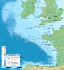
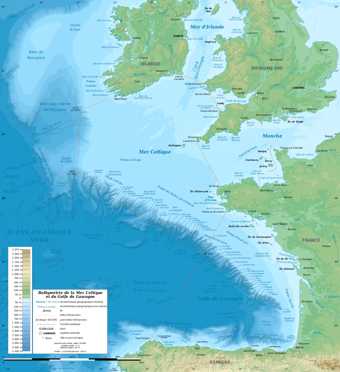
English: Bathymetric map in French of the Celtic Sea and the Bay of Biscay. Limits of the seas as specified by the International Hydrographic Organization. Note: the background map is a raster image embedded in the SVG file.
Français : Carte bathymétrique en français de la Mer Celtique et du Golfe de Gascogne. Limites des mers telles que définies par l'Organisation Hydrographique Internationale. Note : le fond de carte est une image bitmap embarquée dans le fichier SVG.
Polyconic projection; WGS84 datum
origin latitude: 49° N
central meridian: 7° W
Scale: 1:1,912,000 (precision: 478 m)
วันที่
มกราคม พ.ศ. 2554, upgraded 2019-10
แหล่งที่มา
งานของตัว
Sources used:
GEBCO_2019 Grid (public domain)
NGDC GSHHS (public domain)
EEA ECRINS (free)
IHO: Limits of oceans and seas, 4th edition in force in 2019
References:
IHO-IOC GEBCO Undersea Feature Names Gazetteer (on NGDC's Website)
Marine Regions Gazetteer
IFREMER: Menot Lénaik et Van den Beld Inge, Nature, distribution et diversité des habitats de substrats durs du golfe de Gascogne, 2013
Université de Bretagne Occidentale: Charefeddine Assassi, Variabilité interannuelle et analyse de la turbulence géostrophique dans le golfe de Gascogne à partir de simulations, thèse, 2015
IFREMER: Sibuet Jean-Claude et al., Carte bathymétrique de l'Atlantique nord-est et du golfe de Gascogne, 2003-2004
IFREMER: Le Suavé Raymond et al., La marge nord du golfe de Gascogne, 2000
Université de Bretagne Occidentale: Mansor Sandra, Faciès sismiques et architecture du système turbiditique armoricain, 2004
Deep Sea Drilling Project: Montadert L. et al., Rifting and subsidence of the northern continental margin of the Bay of Biscay
Géosciences Montpellier: Lallemand Serge and Sibuet Jean-Claude, Tectonic implications of canyon directions over the northeast Atlantic continental margin, 1986
Université Bordeaux 1: Mas Virginie, Processus sédimentaires et conditions environnementales enregistrées sur la pente continentale du Golfe de Gascogne, 2004
Search and Discovery: D. Van Rooij et al., Neogene sedimentary processes of submarine channels, West off Ireland, 2009
NGA: Undersea features gazetteer, 2009
European Commission: Maratlas
ผู้สร้างสรรค์
Eric Gaba (Sting - fr:Sting)
การอนุญาต (การใช้ไฟล์นี้ใหม่)
Attribution and Share-Alike required
Any use of this map can be made as long as you credit me (Eric Gaba – Wikimedia Commons user: Sting) as the author and distribute the copies and derivative works under the same license(s) that the one(s) stated below. A message with a reply address would also be greatly appreciated.
This map uses embedded text that can be easily translated using a text editor.
This W3C-invalid map was improved or created by the Wikigraphists of the Graphic Lab (fr). You can propose images to clean up, improve, create or translate as well.
This SVG map uses embedded raster graphics to show its topographic structures.
== {{int:filedesc}} == {{Information |Description={{en|Bathymetric map in French of the Celtic Sea and the Bay of Biscay.<br/> ''Note: the background map is a raster image embedded in the SVG file.''}} {{fr|Carte b
Bathymetric map of the Celtic Sea and the Bay of Biscay
ความกว้าง
3478
ความสูง
3804
มิถุนายน 19, 2023
ไฟล, celtic, biscay, bathymetric, ไฟล, ประว, ไฟล, หน, าท, ภาพน, การใช, ไฟล, วนกลาง, อม, ลเก, ยวก, บภาพขนาดของต, วอย, าง, ของไฟล, กเซล, ความละเอ, ยดอ, กเซล, กเซล, กเซล, กเซล, กเซล, กเซล, ภาพท, ความละเอ, ยดส, งกว, 8206, ไฟล, กเซล, ขนาดไฟล, เมกะไบต, ปภาพหร, อไฟล,. ifl prawtiifl hnathimiphaphni karichiflswnklang khxmulekiywkbphaphkhnadkhxngtwxyang PNG nikhxngifl SVG ni 548 599 phikesl khwamlaexiydxun 219 240 phikesl 439 480 phikesl 702 768 phikesl 936 1 024 phikesl 1 872 2 048 phikesl 3 478 3 804 phikesl duphaphthimikhwamlaexiydsungkwa 8206 ifl SVG 3 478 3 804 phikesl khnadifl 4 93 emkaibt rupphaphhruxiflesiyngni tnchbbxyuthi khxmmxns raylaexiyddanlang epnkhxkhwamthiaesdngphlcak ifltnchbbinkhxmmxns khxmmxnsepnewbistinokhrngkarsahrbekbrwbrwmsuxesri thi khunsamarthchwyid khwamyx khaxthibayCeltic Sea and Bay of Biscay bathymetric map fr svg English Bathymetric map in French of the Celtic Sea and the Bay of Biscay Limits of the seas as specified by the International Hydrographic Organization Note the background map is a raster image embedded in the SVG file Francais nbsp Carte bathymetrique en francais de la Mer Celtique et du Golfe de Gascogne Limites des mers telles que definies par l Organisation Hydrographique Internationale Note nbsp le fond de carte est une image bitmap embarquee dans le fichier SVG Polyconic projection WGS84 datum origin latitude 49 N central meridian 7 W Scale 1 1 912 000 precision 478 m wnthi mkrakhm ph s 2554 upgraded 2019 10 aehlngthima ngankhxngtw Sources used GEBCO 2019 Grid public domain NGDC GSHHS public domain EEA ECRINS free IHO Limits of oceans and seas 4th edition in force in 2019 References IHO IOC GEBCO Undersea Feature Names Gazetteer on NGDC s Website Marine Regions Gazetteer IFREMER Menot Lenaik et Van den Beld Inge Nature distribution et diversite des habitats de substrats durs du golfe de Gascogne 2013 Universite de Bretagne Occidentale Charefeddine Assassi Variabilite interannuelle et analyse de la turbulence geostrophique dans le golfe de Gascogne a partir de simulations these 2015 IFREMER Sibuet Jean Claude et al Carte bathymetrique de l Atlantique nord est et du golfe de Gascogne 2003 2004 IFREMER Le Suave Raymond et al La marge nord du golfe de Gascogne 2000 Universite de Bretagne Occidentale Mansor Sandra Facies sismiques et architecture du systeme turbiditique armoricain 2004 Deep Sea Drilling Project Montadert L et al Rifting and subsidence of the northern continental margin of the Bay of Biscay Geosciences Montpellier Lallemand Serge and Sibuet Jean Claude Tectonic implications of canyon directions over the northeast Atlantic continental margin 1986 Universite Bordeaux 1 Mas Virginie Processus sedimentaires et conditions environnementales enregistrees sur la pente continentale du Golfe de Gascogne 2004 Search and Discovery D Van Rooij et al Neogene sedimentary processes of submarine channels West off Ireland 2009 NGA Undersea features gazetteer 2009 European Commission Maratlas phusrangsrrkh Eric Gaba Sting fr Sting karxnuyat karichiflniihm Attribution and Share Alike required Any use of this map can be made as long as you credit me Eric Gaba Wikimedia Commons user Sting as the author and distribute the copies and derivative works under the same license s that the one s stated below A message with a reply address would also be greatly appreciated ewxrchnxun aekikh francais original Basque English Macedonian SVG nbsp genesisInfoField nbsp sxrsokhdkhxngifl SVG khnadihyniimthuktxng nbsp enuxngcakmikhxphidphlad nbsp iflphaphkrafiksewketxr nbsp W3C trwcsxbaelwmikhxphidphladiniflthimikhnadihymakni srangkhunodyich nbsp QGIS nbsp This map uses embedded text nbsp that can be easily translated using a text editor This W3C invalid map was improved or created by the Wikigraphists of the Graphic Lab fr You can propose images to clean up improve create or translate as well nbsp nbsp This SVG map uses embedded raster graphics to show its topographic structures taaehnngthitngklxng49 nbsp 00 nbsp 00 nbsp ehnux 7 nbsp 00 nbsp 00 nbsp tawntk nbsp phaphniaelaphaphxun n sthanthiediywknthi OpenStreetMap49 000000 7 000000 karxnuyatichsiththi Eric Gaba Wikimedia Commons user Sting inthanaphuthuxlikhsiththikhxngphaphhruxsuxni xnuyatihichphaphhruxsuxniphayitenguxnikhtxipniiflnixyuphayitsyyaxnuyat khriexthifkhxmmxns aebbaesdngthima xnuyataebbediywkn 3 0 tnchbbkaraesdngthima Eric Gaba Wikimedia Commons user Sting khunsamarth thicaaebngpn thicathasaena aeckcay aelasngngandngklawtxip thicaeriyberiyngihm thicaddaeplngngandngklaw phayitenguxnikhtxipni aesdngthima khuntxngihekiyrtiecakhxngnganxyangehmaasm odyephimlingkipyngsyyaxnuyat aelarabuhakmikarepliynaeplng khunxacthaechnniidinrupaebbidkidtamkhwr aettxngimichinlksnathiaenawaphuihxnuyatsnbsnunkhunhruxkarichngankhxngkhun xnuyataebbediywkn hakkhunddaeplng epliynrup hruxtxetimnganni khuntxngichsyyaxnuyataebbediywknhruxaebbthiehmuxnkbsyyaxnuyatthiichkbnganniethannhttps creativecommons org licenses by sa 3 0 CC BY SA 3 0 Creative Commons Attribution Share Alike 3 0 true truekhabrryayodyyxithyephimkhabrryaythrrthdediywephuxkhyaykhwamwaiflnimixairfrngessCarte bathymetrique de la Mer celtique et du golfe de Gascogne fr ixethmthiaesdngxyuiniflniprakxbdwyphusrangbangkhathiimmiixethmwikisnethschuxphusrangsrrkh Stingchuxphuichwikimiediy Stingyuxaraexl http commons wikimedia org wiki User StingsthanalikhsiththimilikhsiththisyyaxnuyatCreative Commons Attribution ShareAlike 3 0 Unported nbsp xngkvsthimakhxngiflkarsrangdngedimodyphuxpohldcoordinates of the point of view nbsp xngkvs49 0 0 000 N 7 0 0 000 WMIME type nbsp xngkvsimage svg xml prawtiifl khlikwnthi ewlaephuxduiflthipraktinkhnann wnthi ewlarupyxkhnadphuichkhwamehn pccubn20 11 4 phvscikayn 25623 478 3 804 4 93 emkaibt StingCorrection of a name 03 56 29 tulakhm 25623 478 3 804 4 92 emkaibt StingNew map using GEBCO 15 Sec topographic data rivers from ECRINS added names 01 15 25 mkrakhm 25541 749 1 913 613 kiolibt StingA few more names 23 54 23 mkrakhm 25541 749 1 913 610 kiolibt StingAdded maritim features names 10 26 23 mkrakhm 25541 749 1 913 559 kiolibt Sting int filedesc Information Description en Bathymetric map in French of the Celtic Sea and the Bay of Biscay lt br gt 039 039 Note the background map is a raster image embedded in the SVG file 039 039 fr Carte b hnathimiphaphni hnatxipni oyngmathiphaphni thaelekhltik karichiflswnklang wikixuntxipniichiflni karichbn ar wikipedia org البحر الكلتي karichbn bs wikipedia org Keltsko more karichbn cs wikipedia org Biskajsky zaliv karichbn de wikipedia org Lokalisierungshypothesen zu Atlantis Benutzer Polentarion Bullshitbingo karichbn el wikipedia org Keltikh 8alassa karichbn eo wikipedia org Kelta Maro karichbn fr wikipedia org Gollum Mer Celtique Golfe de Gascogne Wikipedia Atelier graphique Cartes Archives janvier 2011 Atlas maritime Peche bigoudene Edouard Le Danois Banc La Chapelle karichbn gv wikipedia org Baie ny Biscaayn karichbn hr wikipedia org Keltsko more karichbn mr wikipedia org स ल ट क सम द र karichbn oc wikipedia org Mar Celtica karichbn pl wiktionary org golfe de Gascogne Morze Celtyckie karichbn sh wikipedia org Keltsko more karichbn sr wikipedia org Keltsko more karichbn sv wikipedia org Keltiska havet karichbn ta wikipedia org ச ல ட ட க கடல karichbn ur wikipedia org بحیرہ سیلٹک karichbn www wikidata org Q41573 Q81499 Q17626172khxmulekiywkbphaph phaphnimikhxmulephimetim sungswnihymacakklxngdicitxlhruxsaeknenxrthisamarthekbkhxmuldngklawiwrwmkbphaphid thaphaphnithukprbprungaekikhhruxepliynaeplngcakedim khxmulbangxyangcayngkhngimepliynaeplngehmuxnphaphthithukprbprungaekikhnnchuxeruxngsnBathymetric map of the Celtic Sea and the Bay of Biscaykhwamkwang3478khwamsung3804 ekhathungcak https th wikipedia org wiki ifl Celtic Sea and Bay of Biscay bathymetric map fr svg, wikipedia, วิกิ หนังสือ, หนังสือ, ห้องสมุด,