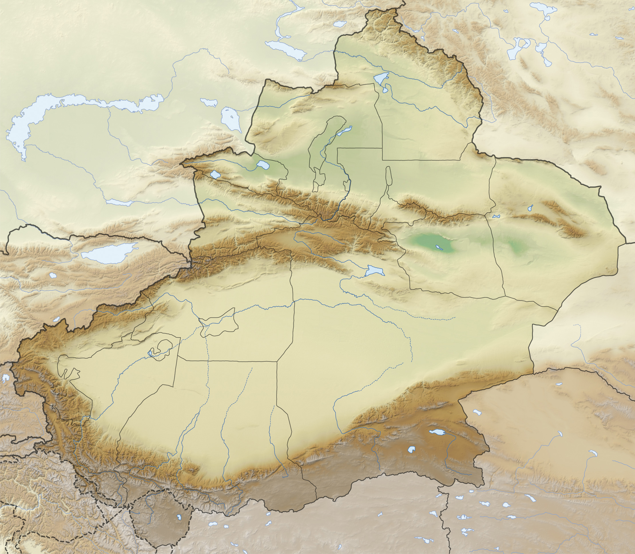
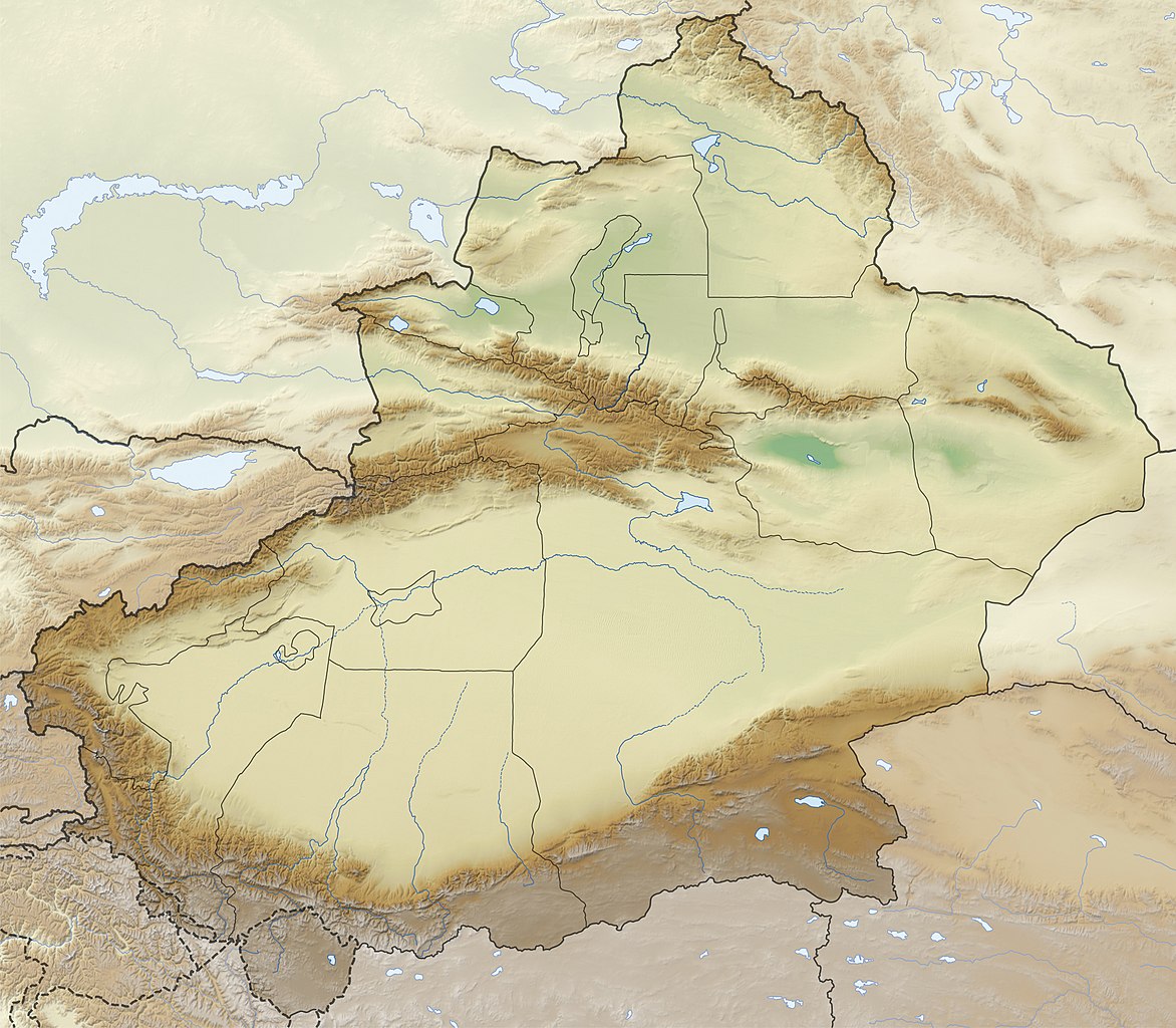
The image contains one or several undisputed inaccuracies. It should not be used to illustrate or provide information about the subject, but may be kept in order to provide the basis for a corrected image. If you disagree that it may be useful for this purpose feel free to request deletion.
This file requires updating because: The China-Tajikistan border has changed, the Kazakhstan-Russia border is inexplicably missing, Kunyu, Xinjiang is not included, etc. problems In doing so, you could add a timestamp to the file.
Please notify the uploader with {{subst:update-note|1=File:China Xinjiang relief location map.jpg|2=The China-Tajikistan border has changed, the Kazakhstan-Russia border is inexplicably missing, Kunyu, Xinjiang is not included, etc. problems}} ~~~~
ความย่อ
คำอธิบายChina Xinjiang relief location map.jpg
Deutsch: Positionskarte von Xinjiang, Volksrepublik China
Quadratische Plattkarte, N-S-Streckung 135 %. Geographische Begrenzung der Karte:
N: 49.4° N
S: 34.2° N
W: 73.2° O
O: 96.7° O
English: Location map of Xinjiang, People's Republic of China
Equirectangular projection, N/S stretching 135 %. Geographic limits of the map:
N: 49.4° N
S: 34.2° N
W: 73.2° E
E: 96.7° E
วันที่
แหล่งที่มา
งานของตัว, using
United States National Imagery and Mapping Agency data
World Data Base II data
Xinjiang Uygur autonomous region administrative regions GIS data: 1:1.000.000, County level, 1990
GTOPO30 data
ผู้สร้างสรรค์
NordNordWest
การอนุญาต (การใช้ไฟล์นี้ใหม่)
I have published this file as author NordNordWest under the "CC-BY-SA-3.0-DE" in Wikipedia. This means that free, commercial usage outside of Wikipedia is permitted under the following licence terms:
Online media:
The author "NordNordWest/Wikipedia" is named
A weblink to the original file is provided: //commons.wikimedia.org/wiki/File:China_Xinjiang_relief_location_map.jpg
Please send me a specimen copy or the URL of the website where the file is used.
Please write an email to nnwest[at]web.de if you
need my postal address for sending a specimen copy
have further questions about the terms of the licence
PS: In case of refusal of the above terms the author reserves the right to take legal action.
This file has been released under a license which is incompatible with Facebook's licensing terms. It is not permitted to upload this file to Facebook.
azərbaycanca ∙ Deutsch (Sie-Form) ∙ čeština ∙ Deutsch ∙ sicilianu ∙ italiano ∙ русский ∙ română ∙ português ∙ English ∙ magyar ∙ Nederlands ∙ slovenščina ∙ polski ∙ latviešu ∙ македонски ∙ español ∙ فارسی ∙ français ∙ suomi ∙ עברית ∙ Plattdüütsch ∙ ქართული ∙ հայերեն ∙ বাংলা ∙ ไทย ∙ 日本語 ∙ 中文 ∙ 中文(简体) ∙ 中文(繁體) ∙ العربية ∙ +/−
ไฟล, china, xinjiang, relief, location, ไฟล, ประว, ไฟล, หน, าท, ภาพน, การใช, ไฟล, วนกลาง, อม, ลเก, ยวก, บภาพขนาดของต, วอย, างน, กเซล, ความละเอ, ยดอ, กเซล, กเซล, กเซล, กเซล, กเซล, ภาพท, ความละเอ, ยดส, งกว, 8206, กเซล, ขนาดไฟล, เมกะไบต, ชน, ดไมม, image, jpeg, ปภ. ifl prawtiifl hnathimiphaphni karichiflswnklang khxmulekiywkbphaphkhnadkhxngtwxyangni 686 599 phikesl khwamlaexiydxun 275 240 phikesl 550 480 phikesl 879 768 phikesl 1 172 1 024 phikesl 2 220 1 939 phikesl duphaphthimikhwamlaexiydsungkwa 8206 2 220 1 939 phikesl khnadifl 1 38 emkaibt chnidimm image jpeg rupphaphhruxiflesiyngni tnchbbxyuthi khxmmxns raylaexiyddanlang epnkhxkhwamthiaesdngphlcak ifltnchbbinkhxmmxns khxmmxnsepnewbistinokhrngkarsahrbekbrwbrwmsuxesri thi khunsamarthchwyid The image contains one or several undisputed inaccuracies It should not be used to illustrate or provide information about the subject but may be kept in order to provide the basis for a corrected image If you disagree that it may be useful for this purpose feel free to request deletion This file requires updating because The China Tajikistan border has changed the Kazakhstan Russia border is inexplicably missing Kunyu Xinjiang is not included etc problems In doing so you could add a timestamp to the file Please notify the uploader with code subst update note 1 File China Xinjiang relief location map jpg 2 The China Tajikistan border has changed the Kazakhstan Russia border is inexplicably missing Kunyu Xinjiang is not included etc problems code khwamyx khaxthibayChina Xinjiang relief location map jpg Deutsch Positionskarte von Xinjiang Volksrepublik China Quadratische Plattkarte N S Streckung 135 Geographische Begrenzung der Karte N 49 4 N S 34 2 N W 73 2 O O 96 7 OEnglish Location map of Xinjiang People s Republic of China Equirectangular projection N S stretching 135 Geographic limits of the map N 49 4 N S 34 2 N W 73 2 E E 96 7 Ewnthi 26 phvscikayn ph s 2555aehlngthima ngankhxngtw using United States National Imagery and Mapping Agency data World Data Base II data Xinjiang Uygur autonomous region administrative regions GIS data 1 1 000 000 County level 1990 GTOPO30 dataphusrangsrrkh NordNordWestkarxnuyat karichiflniihm I have published this file as author NordNordWest under the CC BY SA 3 0 DE in Wikipedia This means that free commercial usage outside of Wikipedia is permitted under the following licence terms Online media The author NordNordWest Wikipedia is named A weblink to the original file is provided commons wikimedia org wiki File China Xinjiang relief location map jpg A copy of or the Uniform Resource Identifier https creativecommons org licenses by sa 3 0 de legalcode for this licence with every copy Print media The author NordNordWest Wikipedia is named A copy of or the Uniform Resource Identifier https creativecommons org licenses by sa 3 0 de legalcode for this licence with every copyPlease send me a specimen copy or the URL of the website where the file is used Please write an email to nnwest at web de if you need my postal address for sending a specimen copy have further questions about the terms of the licencePS In case of refusal of the above terms the author reserves the right to take legal action This file has been released under a license which is incompatible with Facebook s licensing terms It is not permitted to upload this file to Facebook iflnixyuphayitsyyaxnuyat khriexthifkhxmmxns aebbaesdngthima xnuyataebbediywkn 3 0 khxngpraethseyxrmnikhunsamarth thicaaebngpn thicathasaena aeckcay aelasngngandngklawtxip thicaeriyberiyngihm thicaddaeplngngandngklaw phayitenguxnikhtxipni aesdngthima khuntxngihekiyrtiecakhxngnganxyangehmaasm odyephimlingkipyngsyyaxnuyat aelarabuhakmikarepliynaeplng khunxacthaechnniidinrupaebbidkidtamkhwr aettxngimichinlksnathiaenawaphuihxnuyatsnbsnunkhunhruxkarichngankhxngkhun xnuyataebbediywkn hakkhunddaeplng epliynrup hruxtxetimnganni khuntxngichsyyaxnuyataebbediywknhruxaebbthiehmuxnkbsyyaxnuyatthiichkbnganniethannhttps creativecommons org licenses by sa 3 0 de deed en CC BY SA 3 0 de Creative Commons Attribution Share Alike 3 0 de true trueewxrchnxun administrative version aephnthinithuksranghruxphthnakhuncak Kartenwerkstatt hxngptibtikaraephnthi khxngwikiphiediyphasaeyxrmn sungkhunsamarthesnxaephnthiephuxphthnaidechnediywkn azerbaycanca Deutsch Sie Form cestina Deutsch sicilianu italiano russkij romană portugues English magyar Nederlands slovenscina polski latviesu makedonski espanol فارسی francais suomi עברית Plattduutsch ქართული հայերեն ব ল ithy 日本語 中文 中文 简体 中文 繁體 العربية karxnuyatichsiththi iflnixyuphayitsyyaxnuyat khriexthifkhxmmxns aebbaesdngthima xnuyataebbediywkn 3 0 khxngpraethseyxrmnikhunsamarth thicaaebngpn thicathasaena aeckcay aelasngngandngklawtxip thicaeriyberiyngihm thicaddaeplngngandngklaw phayitenguxnikhtxipni aesdngthima khuntxngihekiyrtiecakhxngnganxyangehmaasm odyephimlingkipyngsyyaxnuyat aelarabuhakmikarepliynaeplng khunxacthaechnniidinrupaebbidkidtamkhwr aettxngimichinlksnathiaenawaphuihxnuyatsnbsnunkhunhruxkarichngankhxngkhun xnuyataebbediywkn hakkhunddaeplng epliynrup hruxtxetimnganni khuntxngichsyyaxnuyataebbediywknhruxaebbthiehmuxnkbsyyaxnuyatthiichkbnganniethannhttps creativecommons org licenses by sa 3 0 de deed en CC BY SA 3 0 de Creative Commons Attribution Share Alike 3 0 de true truekhabrryayodyyxithyephimkhabrryaythrrthdediywephuxkhyaykhwamwaiflnimixairixethmthiaesdngxyuiniflniprakxbdwyphusrangbangkhathiimmiixethmwikisnethshnathikhxngwtthuphayitpraphcnni changphaphchuxphusrangsrrkh NordNordWestchuxphuichwikimiediy NordNordWestyuxaraexl http commons wikimedia org wiki User NordNordWeststhanalikhsiththimilikhsiththisyyaxnuyatCreative Commons Attribution ShareAlike 3 0 Germany xngkvswnthisrang wnkxtng26 phvscikayn 2012thimakhxngiflkarsrangdngedimodyphuxpohldMIME type xngkvsimage jpeg prawtiifl khlikwnthi ewlaephuxduiflthipraktinkhnann wnthi ewlarupyxkhnadphuichkhwamehn pccubn22 36 28 thnwakhm 25552 220 1 939 1 38 emkaibt NordNordWestupd 04 38 27 phvscikayn 25552 220 1 939 1 38 emkaibt NordNordWest int filedesc Information Description de Positionskarte von Xinjiang Volksrepublik China Quadratische Plattkarte N S Streckung 135 Geographische Begrenzung der Karte N 49 4 N S 3 hnathimiphaphni hnatxipni oyngmathiphaphni changci chxngekhakhunecrab ekhthu mxdul Location map data China Xinjiang mxdul Location map data China Xinjiang doc karichiflswnklang wikixuntxipniichiflni karichbn arz wikipedia org جبل كيزهين پياك karichbn bg wikipedia org Kashgar Turfan Lobnor Urumchi Korla Aksu Shhdz Hotan Tarim Shablon PK Kitaj Sindzyan ujgurski avtonomen region Ebinur Karashar Kucha Turfanska padina Manas reka v Kitaj Ruski hrebet Tarbagataj Hami Cherchen reka Cherchen Yarkend Saur Emel Tekes Artush Altntag Arkatag Bogdo Ula Kashgarski hrebet Kongur planinski masiv Kuruktag Gashunska Gobi Kuldzhinska ravnina Hamijska kotlovina Borotala Kash Keriya Konchedarya Kunges Urungu Hotan reka Yarkend reka Bagrashkol Barkol Ajdnkol Karaburankol Ulyungur Gozdarya karichbn ce wikipedia org Kep Mettigan karta Kitaj Sinczyan Ujgurijn avtonomin kӀosht dukarichthwolkephimetimkhxngiflnikhxmulekiywkbphaph phaphnimikhxmulephimetim sungswnihymacakklxngdicitxlhruxsaeknenxrthisamarthekbkhxmuldngklawiwrwmkbphaphid thaphaphnithukprbprungaekikhhruxepliynaeplngcakedim khxmulbangxyangcayngkhngimepliynaeplngehmuxnphaphthithukprbprungaekikhnnkarcdwangphaphpktikhwamlaexiydaenwnxn72 dpikhwamlaexiydaenwtng72 dpisxftaewrthiichAdobe Photoshop CS4 Macintoshaekikhphaphlasud16 34 28 thnwakhm 2555sepssiimidprbethiybkhwamkwangkhxngphaph2 220 phikeslkhwamsungkhxngphaph1 939 phikeslewlathiaeplngepndicithl23 25 26 phvscikayn 2555wnthiaekikhkhxmulemtalasud17 34 28 thnwakhm 2555ID echphaakhxngexksartnchbbxmp did 74117FE320071168A7BADDC38E4CB531 ekhathungcak https th wikipedia org wiki ifl China Xinjiang relief location map jpg, wikipedia, วิกิ หนังสือ, หนังสือ, ห้องสมุด,