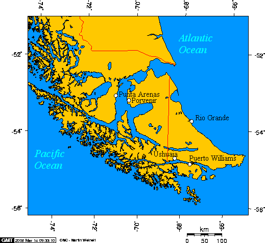
This map is taken from en:Image:Cities of Tierra del Fuego.png and was created with this online map creation tool . Uploaded by en:User:Geo Swan on 14 March 2005.
This image was copied from wikipedia:en. The original description was: Cities of Tierra del Fuego {{GFDL}} This map was created with this [http://www.aquarius.geomar.de/omc/ online map creation tool]. The longitude and latitude of the cities follow: *-
Cities of Tierra del Fuego {{GFDL}} This map is taken from en:Image:Cities of Tierra del Fuego.png and was created with this [http://www.aquarius.geomar.de/omc/ online map creation tool]. The longitude and latitude of the cities follow: *-70.9333,-
ไฟล, cities, tierra, fuego, ไฟล, ประว, ไฟล, หน, าท, ภาพน, การใช, ไฟล, วนกลางไม, ภาพท, รายละเอ, ยดส, งกว, าน, cities, tierra, fuego, 8206, กเซล, ขนาดไฟล, โลไบต, ชน, ดไมม, image, ปภาพหร, อไฟล, เส, ยงน, นฉบ, บอย, คอมมอนส, รายละเอ, ยดด, านล, าง, เป, นข, อความท, แส. ifl prawtiifl hnathimiphaphni karichiflswnklangimmiphaphthimiraylaexiydsungkwani Cities of Tierra del Fuego png 8206 519 475 phikesl khnadifl 21 kiolibt chnidimm image png rupphaphhruxiflesiyngni tnchbbxyuthi khxmmxns raylaexiyddanlang epnkhxkhwamthiaesdngphlcak ifltnchbbinkhxmmxns khxmmxnsepnewbistinokhrngkarsahrbekbrwbrwmsuxesri thi khunsamarthchwyid English Cities of Tierra del Fuego Esperanto Urboj de Fuegio Espanol Ciudades de Tierra del Fuego xnuyatihkhdlxk aeckcayaela hruxddaeprexksarniphayitenguxnikhkhxngsyyaxnuyatexksaresrikhxngknu run 1 2 hruxrunid nbcaknithixxkodymulnithisxftaewresri odyimmiswnidhamaekikh immikhxkhwampkhnaaelapkhlng saenakhxngsyyaxnuyatrwmxyuinswnchux syyaxnuyatexksaresrikhxngknuhttp www gnu org copyleft fdl html GFDL GNU Free Documentation License true trueiflnixyuphayitsyyaxnuyat khriexthifkhxmmxns aebbaesdngthima xnuyataebbediywkn 3 0 tnchbbkhunsamarth thicaaebngpn thicathasaena aeckcay aelasngngandngklawtxip thicaeriyberiyngihm thicaddaeplngngandngklaw phayitenguxnikhtxipni aesdngthima khuntxngihekiyrtiecakhxngnganxyangehmaasm odyephimlingkipyngsyyaxnuyat aelarabuhakmikarepliynaeplng khunxacthaechnniidinrupaebbidkidtamkhwr aettxngimichinlksnathiaenawaphuihxnuyatsnbsnunkhunhruxkarichngankhxngkhun xnuyataebbediywkn hakkhunddaeplng epliynrup hruxtxetimnganni khuntxngichsyyaxnuyataebbediywknhruxaebbthiehmuxnkbsyyaxnuyatthiichkbnganniethannpayaesdngsthanalikhsiththinithukephimephuxihepniptamkarepliynaeplngsyyaxnuyatkhxngmulnithiwikimiediy cak GFDL ipyng GFDL khwbkhukb CC BY SA 3 0 http creativecommons org licenses by sa 3 0 CC BY SA 3 0 Creative Commons Attribution Share Alike 3 0 true trueThis map is taken from en Image Cities of Tierra del Fuego png and was created with this online map creation tool archive copy Uploaded by en User Geo Swan on 14 March 2005 The longitude and latitude of the cities follow 70 9333 53 1666 Punta Arenas 70 3648 53 2959 Porvenir 67 6167 54 9333 Puerto Williams 68 2978 54 7921 Ushuaia 67 5982 53 8114 Rio GrandekhabrryayodyyxithyephimkhabrryaythrrthdediywephuxkhyaykhwamwaiflnimixairixethmthiaesdngxyuiniflniprakxbdwysthanalikhsiththimilikhsiththisyyaxnuyatCreative Commons Attribution ShareAlike 3 0 Unported xngkvsGNU Free Documentation License version 1 2 or later xngkvsMIME type xngkvsimage png prawtiifl khlikwnthi ewlaephuxduiflthipraktinkhnann wnthi ewlarupyxkhnadphuichkhwamehn pccubn18 47 6 tulakhm 2548519 475 21 kiolibt ChongDaeThis image was copied from wikipedia en The original description was Cities of Tierra del Fuego GFDL This map was created with this http www aquarius geomar de omc online map creation tool The longitude and latitude of the cities follow 17 46 24 emsayn 2548519 475 21 kiolibt PoulpyCities of Tierra del Fuego GFDL This map is taken from en Image Cities of Tierra del Fuego png and was created with this http www aquarius geomar de omc online map creation tool The longitude and latitude of the cities follow 70 9333 hnathimiphaphni hnatxipni oyngmathiphaphni ekaatiexrraedlfuexok karichiflswnklang wikixuntxipniichiflni karichbn ar wikipedia org أوشوايا karichbn bg wikipedia org Ognena zemya karichbn ca wikipedia org Terra del Foc Portal Geografia Articles seleccionats Plantilla Article geografic de la setmana 31 karichbn ckb wikipedia org ئۆشوایە karichbn cs wikipedia org Ohnova zeme karichbn da wikipedia org Ildlandet Punta Arenas karichbn de wikipedia org Jose Emperaire karichbn el wikipedia org H notioterh polh toy kosmoy karichbn en wikipedia org Southernmost settlements User Geo Swan mymaps Category Tierra del Fuego karichbn eo wikipedia org Punta Arenas karichbn es wikipedia org Servicio Aereo Especial Anexo Poblados mas australes de la Tierra Operacion Mikado Puerto Navarino karichbn fa wikipedia org جنوبی ترین سکونتگاه ها karichbn fr wikipedia org Terre de Feu Ushuaia Activite du Special Air Service durant la guerre des Malouines Jose Emperaire karichbn fy wikipedia org Rio Grande Argentynje karichbn gd wikipedia org Isla Grande de Tierra del Fuego karichbn hr wikipedia org Punta Arenas karichbn id wikipedia org Tierra del Fuego Isla Grande de Tierra del Fuego karichbn it wikipedia org Punta Arenas Puerto Williams Terra del Fuoco karichbn ja wikipedia org ウシュアイア ティエラ デル フエゴ 利用者 Akiyama tentative sandbox テンプレートのテスト karichbn ka wikipedia org ცეცხლოვანი მიწა karichbn ko wikipedia org 티에라델푸에고 제도 karichbn la wikipedia org Terra Ignium Categoria Terra Ignium karichbn lt wikipedia org Ugnies Zeme karichbn mk wikipedia org Ognena Zemјa karichbn ml wikipedia org ഫ ർഡ ന ന റ മഗല ലൻ karichbn nl wikipedia org Punta Arenas Puerto Williams karichbn no wikipedia org Ildlandet Punta Arenas karichbn pl wikipedia org Ziemia Ognista archipelag karichbn pl wiktionary org Ohnova zem karichbn pt wikipedia org Terra do Fogo Aeroporto Internacional Carlos Ibanez del Campo dukarichthwolkephimetimkhxngiflni ekhathungcak https th wikipedia org wiki ifl Cities of Tierra del Fuego png, wikipedia, วิกิ หนังสือ, หนังสือ, ห้องสมุด,