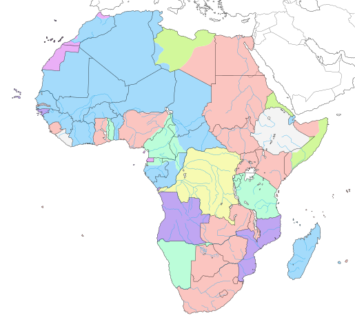
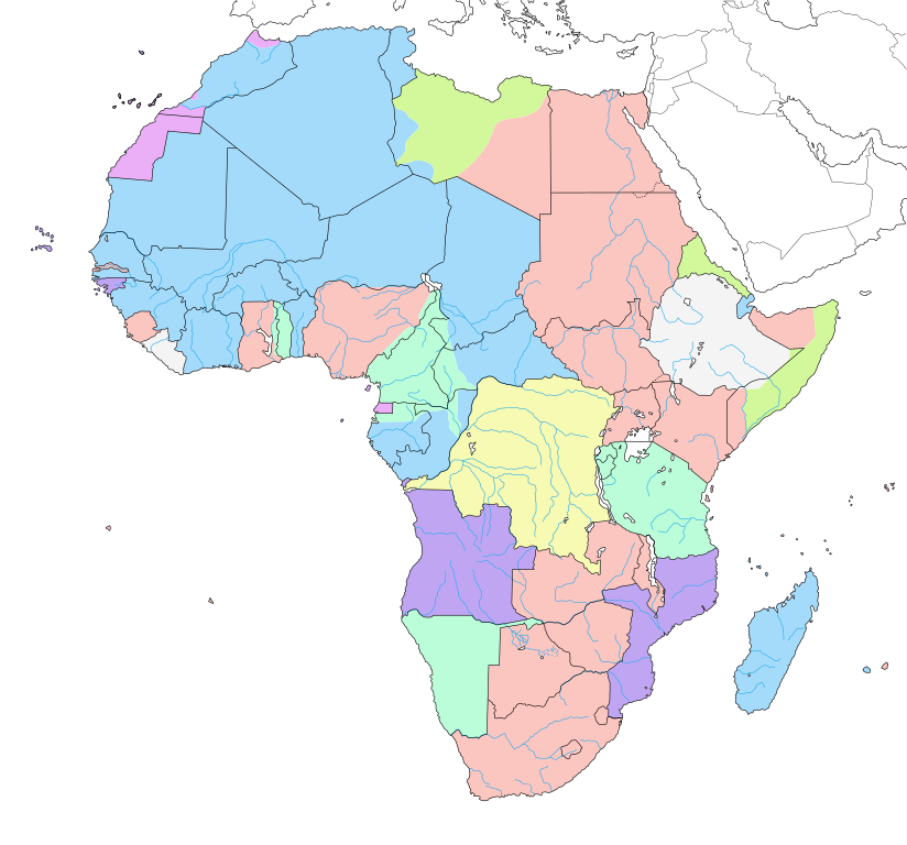
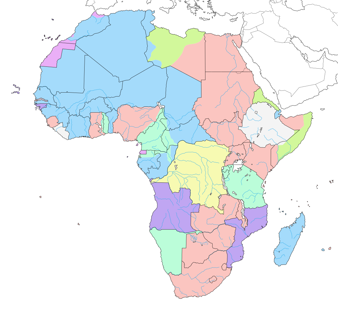
English: Map of colonial Africa as in 1913, with modern borders. Note: The limits of the areas of control may not be perfectly accurate due to the imprecision of the reference maps.
Deutsch: Karte des kolonialen Afrikas von 1913 mit modernen Grenzen. Notiz: Die Grenzen der Kontrollbereiche sind aufgrund der Ungenauigkeit der Referenzkarten möglicherweise nicht ganz genau.
Italiano: Mappa dell'Africa coloniale come nel 1913, con confini moderni. Nota: I limiti delle aree di controllo potrebbero non essere perfettamente precisi a causa dell'imprecisione delle mappe di riferimento.
Español: Mapa del África colonial como en 1913, con fronteras modernas. Nota: Los límites de las áreas de control pueden no ser perfectamente precisos debido a la imprecisión de los mapas de referencia.
Français : Carte de l'Afrique coloniale en 1913, avec frontières modernes. Note : Les limites des zones de contrôle peuvent ne pas être tout à fait exactes en raison de l'imprécision des cartes de référence utilisées.
วันที่
มิถุนายน พ.ศ. 2550, updated/corrected 2011-07
แหล่งที่มา
งานของตัว (Original text: Own work ;)
Background map : Africa map political-fr.svg (this revision) (modified) created by myself ;
Reference maps :
Map by John Bartholomew & Co. visible on Britishempire.co.uk ;
Map from Hammond's Atlas of the Modern World, 1917 ;
Map from WHKMLA Historical Atlas ;
Map from the Texas Education Agency.
ผู้สร้างสรรค์
Eric Gaba (Sting - fr:Sting)
การอนุญาต (การใช้ไฟล์นี้ใหม่)
Attribution and Share-Alike required
Any use of this map can be made as long as you credit me (Eric Gaba – Wikimedia Commons user: Sting) as the author and distribute the copies and derivative works under the same license(s) that the one(s) stated below. A message with a reply address would also be greatly appreciated.
เวอร์ชันอื่น
[แก้ไข]
2342 หรือ 2343
English
2412 หรือ 2413
English
2442 หรือ 2443
English
2454 หรือ 2455 - 2456 หรือ 2457
date QS:P,+1912-00-00T00:00:00Z/8,P1319,+1912-00-00T00:00:00Z/9,P1326,+1914-00-00T00:00:00Z/9
This world map uses embedded text that can be easily translated using a text editor.
This map was improved or created by the Wikigraphists of the Graphic Lab (fr). You can propose images to clean up, improve, create or translate as well.
การอนุญาตใช้สิทธิ
Eric Gaba ในฐานะผู้ถือลิขสิทธิ์ของภาพหรือสื่อนี้ อนุญาตให้ใช้ภาพหรือสื่อนี้ภายใต้เงื่อนไขต่อไปนี้
Map of colonial Africa around 1913, on the current borders.
Mapa del África colonial hacia 1913, en las fronteras actuales.
Mappa dell'Africa coloniale intorno al 1913, negli attuali confini.
Karte des kolonialen Afrikas um 1913, an den heutigen Grenzen.
Kaart van koloniaal Afrika rond 1913, aan de huidige grenzen.
خريطة أفريقيا المستعمرة كما في عام 1913 بحدود حديثة، تحت السياسة الإمبريالية. ملحوظة: قد لا تكون حدود مناطق التحكم دقيقة تمامًا بسبب عدم دقة الخرائط المرجعية.
ไอเทมที่แสดงอยู่ในไฟล์นี้
ประกอบด้วย
สถานะลิขสิทธิ์
มีลิขสิทธิ์
สัญญาอนุญาต
GNU Free Documentation License, version 1.2 or later อังกฤษ
ไฟล, colonial, africa, 1913, ไฟล, ประว, ไฟล, หน, าท, ภาพน, การใช, ไฟล, วนกลาง, อม, ลเก, ยวก, บภาพขนาดของต, วอย, าง, ของไฟล, กเซล, ความละเอ, ยดอ, กเซล, กเซล, กเซล, กเซล, กเซล, กเซล, ภาพท, ความละเอ, ยดส, งกว, 8206, ไฟล, กเซล, ขนาดไฟล, โลไบต, ปภาพหร, อไฟล, เส, ยง. ifl prawtiifl hnathimiphaphni karichiflswnklang khxmulekiywkbphaphkhnadkhxngtwxyang PNG nikhxngifl SVG ni 644 600 phikesl khwamlaexiydxun 258 240 phikesl 515 480 phikesl 824 768 phikesl 1 099 1 024 phikesl 2 198 2 048 phikesl 1 390 1 295 phikesl duphaphthimikhwamlaexiydsungkwa 8206 ifl SVG 1 390 1 295 phikesl khnadifl 660 kiolibt rupphaphhruxiflesiyngni tnchbbxyuthi khxmmxns raylaexiyddanlang epnkhxkhwamthiaesdngphlcak ifltnchbbinkhxmmxns khxmmxnsepnewbistinokhrngkarsahrbekbrwbrwmsuxesri thi khunsamarthchwyid BEL GER ESP FRA GBR ITA PRT Independentالعربية بلجيكا ألمانيا اسبانيا فرنسا بريطانيا إيطاليا البرتغالAzerbaycanca Belcika Almaniya Ispaniya Fransa Boyuk Britaniya Italiya PortuqaliyaBelaruskaya Belgiya Germaniya Ispaniya Francyya Vyalikabrytaniya Italiya PartugaliyaBlgarski Belgiya Germaniya Ispaniya Franciya Velikobritaniya Italiya Portugaliyaব ল ব লজ য ম জ র ম ন স প ন ফ র ন স য ক তর জ য ইত ল পর ত গ লCatala Belgica Alemanya Espanya Franca Gran Bretanya Italia PortugalCestina Belgie Nemecko Spanelsko Francie Velka Britanie Italie PortugalskoCymraeg Gwlad Belg Yr Almaen Sbaen Ffrainc Prydain Fawr Yr Eidal PortiwgalDansk Belgien Tyskland Spanien Frankrig Storbritannien Italien PortugalDeutsch Belgien Deutschland Spanien Frankreich Grossbritannien Italien Portugal Unabhangige StaatenEllhnika Belgio Germania Ispania Gallia Megalh Bretania Italia PortogaliaEnglish Belgium Germany Spain France United Kingdom Italy Portugal Independent StatesEsperanto Belgio Germanio Hispanio Francio Britio Italio PortugalioEspanol Belgica Alemania Espana Francia Gran Bretana Italia Portugal Estados independientesEesti Belgia Saksamaa Hispaania Prantsusmaa Suurbritannia Itaalia PortugalEuskara Belgika Alemania Espainia Frantzia Britainia Handia Italia PortugalSuomi Belgia Saksa Espanja Ranska Iso Britannia Italia PortugaliaFrancais Belgique Allemagne Espagne France Grande Bretagne Italie Portugal Etats independantsGaeilge An Bheilg An Ghearmain An Spainn An Fhrainc An Riocht Aontaithe An Iodail An PhortaingeilGalego Belxica Alemana Espana Francia Gran Bretana Italia PortugalHrvatski Belgija Njemacka Spanjolska Francuska Velika Britanija Italija PortugalMagyar Belgium Nemetorszag Spanyolorszag Franciorszag Nagy Britania Olaszorszag PortugaliaՀայերեն Բելգիա Գերմանիա Իսպանիա Ֆրանսիա Միացյալ Թագավորություն Իտալիա ՊորտուգալիաBahasa Indonesia Belgia Jerman Spanyol Prancis Britania Raya Italia Portugal Negara independenIslenska Belgia THyskaland Spann Frakkland Stora Bretland Italia PortugalItaliano Belgio Germania Spagna Francia Regno Unito Italia Portogalloქართული ბელგია გერმანია ესპანეთი საფრანგეთი გაერთიანებული სამეფო იტალია პორტუგალია한국어 벨기에 독일 스페인 프랑스 영국 이탈리아 포르투갈Lietuviu Belgija Vokietija Ispanija Prancuzija D Britanija Italija PortugalijaLatviesu Belgija Vacija Spanija Francija Lielbritanija Italija PortugaleMakedonski Belgiјa Germaniјa Shpaniјa Franciјa Velika Britaniјa Italiјa PortugaliјaMalti Belġju Ġermanja Spanja Franza Gran Brittanja Italja PortugallNederlands Belgie Duitsland Spanje Frankrijk Groot Brittannie Italie Portugal Onafhankelijke gebiedenNorsk bokmal Belgia Tyskland Spania Frankrike Storbritannia Italia PortugalPolski Belgia Niemcy Hiszpania Francja Wielka Brytania Wlochy PortugaliaPortugues Belgica Alemanha Espanha Franca Gra Bretanha Italia Portugal Estados independentesRomană Belgia Germania Spania Franţa Regatul Unit Italia PortugaliaRusskij Belgiya Germaniya Ispaniya Franciya Velikobritaniya Italiya PortugaliyaSlovencina Belgicko Nemecko Spanielsko Francuzsko Veľka Britania Taliansko PortugalskoSlovenscina Belgija Nemcija Spanija Francija Velika Britanija Italija PortugalskaShqip Belgjika Gjermanija Spanja Franca Britanise se Madhe Italia PortugaliaSrpski srpski Belgiјa Nemachka Shpaniјa Francuska Velika Britaniјa Italiјa PortugaliјaSvenska Belgien Tyskland Spanien Frankrike Storbritannien Italien PortugalKiswahili Ubelgiji Ujerumani Hispania Ufaransa Ufalme wa Muungano Italia UrenoTurkce Belcika Almanya Ispanya Fransa Buyuk Britanya Italya PortekizUkrayinska Belgiya Nimechchina Ispaniya Franciya Velika Britaniya Italiya PortugaliyaTiếng Việt Bỉ Đức Tay Ban Nha Phap Anh Y Bồ Đao Nha中文 比利时 德国 西班牙 法国 英国 意大利 葡萄牙khwamyx khaxthibayColonial Africa 1913 map svg English Map of colonial Africa as in 1913 with modern borders Note The limits of the areas of control may not be perfectly accurate due to the imprecision of the reference maps Deutsch Karte des kolonialen Afrikas von 1913 mit modernen Grenzen Notiz Die Grenzen der Kontrollbereiche sind aufgrund der Ungenauigkeit der Referenzkarten moglicherweise nicht ganz genau Italiano Mappa dell Africa coloniale come nel 1913 con confini moderni Nota I limiti delle aree di controllo potrebbero non essere perfettamente precisi a causa dell imprecisione delle mappe di riferimento Espanol Mapa del Africa colonial como en 1913 con fronteras modernas Nota Los limites de las areas de control pueden no ser perfectamente precisos debido a la imprecision de los mapas de referencia Francais Carte de l Afrique coloniale en 1913 avec frontieres modernes Note Les limites des zones de controle peuvent ne pas etre tout a fait exactes en raison de l imprecision des cartes de reference utilisees wnthi mithunayn ph s 2550 updated corrected 2011 07aehlngthima ngankhxngtw Original text Own work Background map Africa map political fr svg this revision modified created by myself Reference maps Map by John Bartholomew amp Co visible on Britishempire co uk Map from Hammond s Atlas of the Modern World 1917 Map from WHKMLA Historical Atlas Map from the Texas Education Agency phusrangsrrkh Eric Gaba Sting fr Sting karxnuyat karichiflniihm Attribution and Share Alike requiredAny use of this map can be made as long as you credit me Eric Gaba Wikimedia Commons user Sting as the author and distribute the copies and derivative works under the same license s that the one s stated below A message with a reply address would also be greatly appreciated ewxrchnxun aekikh 2342 hrux 2343English2412 hrux 2413English2442 hrux 2443English2454 hrux 2455 2456 hrux 2457 date QS P 1912 00 00T00 00 00Z 8 P1319 1912 00 00T00 00 00Z 9 P1326 1914 00 00T00 00 00Z 9espanol Deutsch asturianu Ban lam gu cestina dansk Deutsch Deutsch Deutsch English English English English English espanol espanol espanol espanol euskara euskara foroyskt Kiswahili norsk polski polski svenska blgarski srpski ћirilica srpski ћirilica Ellhnika 中文 中文2465 hrux 2466English2481 hrux 2482espanolph s 2490espanol polskiSVG genesisInfoField sxrsokhdkhxng SVG nitrwcsxbthuktxngaelw iflphaphkrafiksewketxrni srangkhunodyich Adobe Illustrator aelaody Inkscape This world map uses embedded text that can be easily translated using a text editor This map was improved or created by the Wikigraphists of the Graphic Lab fr You can propose images to clean up improve create or translate as well karxnuyatichsiththi Eric Gaba inthanaphuthuxlikhsiththikhxngphaphhruxsuxni xnuyatihichphaphhruxsuxniphayitenguxnikhtxipni xnuyatihkhdlxk aeckcayaela hruxddaeprexksarniphayitenguxnikhkhxngsyyaxnuyatexksaresrikhxngknu run 1 2 hruxrunid nbcaknithixxkodymulnithisxftaewresri odyimmiswnidhamaekikh immikhxkhwampkhnaaelapkhlng saenakhxngsyyaxnuyatrwmxyuinswnchux syyaxnuyatexksaresrikhxngknuhttp www gnu org copyleft fdl html GFDL GNU Free Documentation License true trueiflnixyuphayitsyyaxnuyat khriexthifkhxmmxns aebbaesdngthima xnuyataebbediywkn 3 0 tnchbbkaraesdngthima Eric Gaba Wikimedia Commons user Stingkhunsamarth thicaaebngpn thicathasaena aeckcay aelasngngandngklawtxip thicaeriyberiyngihm thicaddaeplngngandngklaw phayitenguxnikhtxipni aesdngthima khuntxngihekiyrtiecakhxngnganxyangehmaasm odyephimlingkipyngsyyaxnuyat aelarabuhakmikarepliynaeplng khunxacthaechnniidinrupaebbidkidtamkhwr aettxngimichinlksnathiaenawaphuihxnuyatsnbsnunkhunhruxkarichngankhxngkhun xnuyataebbediywkn hakkhunddaeplng epliynrup hruxtxetimnganni khuntxngichsyyaxnuyataebbediywknhruxaebbthiehmuxnkbsyyaxnuyatthiichkbnganniethannpayaesdngsthanalikhsiththinithukephimephuxihepniptamkarepliynaeplngsyyaxnuyatkhxngmulnithiwikimiediy cak GFDL ipyng GFDL khwbkhukb CC BY SA 3 0 http creativecommons org licenses by sa 3 0 CC BY SA 3 0 Creative Commons Attribution Share Alike 3 0 true trueiflnixyuphayitsyyaxnuyat khriexthifkhxmmxns aebbaesdngthima xnuyataebbediywkn 2 5 thwipkaraesdngthima Eric Gaba Wikimedia Commons user Stingkhunsamarth thicaaebngpn thicathasaena aeckcay aelasngngandngklawtxip thicaeriyberiyngihm thicaddaeplngngandngklaw phayitenguxnikhtxipni aesdngthima khuntxngihekiyrtiecakhxngnganxyangehmaasm odyephimlingkipyngsyyaxnuyat aelarabuhakmikarepliynaeplng khunxacthaechnniidinrupaebbidkidtamkhwr aettxngimichinlksnathiaenawaphuihxnuyatsnbsnunkhunhruxkarichngankhxngkhun xnuyataebbediywkn hakkhunddaeplng epliynrup hruxtxetimnganni khuntxngichsyyaxnuyataebbediywknhruxaebbthiehmuxnkbsyyaxnuyatthiichkbnganniethannhttps creativecommons org licenses by sa 2 5 CC BY SA 2 5 Creative Commons Attribution Share Alike 2 5 true truekhunsamartheluxksyyaxnuyatdngklawtamtxngkarkhabrryayodyyxithyephimkhabrryaythrrthdediywephuxkhyaykhwamwaiflnimixairxngkvsMap of colonial Africa around 1913 on the current borders sepnMapa del Africa colonial hacia 1913 en las fronteras actuales xitaliMappa dell Africa coloniale intorno al 1913 negli attuali confini eyxrmnKarte des kolonialen Afrikas um 1913 an den heutigen Grenzen dtchKaart van koloniaal Afrika rond 1913 aan de huidige grenzen xahrbخريطة أفريقيا المستعمرة كما في عام 1913 بحدود حديثة تحت السياسة الإمبريالية ملحوظة قد لا تكون حدود مناطق التحكم دقيقة تمام ا بسبب عدم دقة الخرائط المرجعية ixethmthiaesdngxyuiniflniprakxbdwysthanalikhsiththimilikhsiththisyyaxnuyatGNU Free Documentation License version 1 2 or later xngkvsCreative Commons Attribution ShareAlike 2 5 Generic xngkvsCreative Commons Attribution ShareAlike 3 0 Unported xngkvsthimakhxngiflkarsrangdngedimodyphuxpohldMIME type xngkvsimage svg xml prawtiifl khlikwnthi ewlaephuxduiflthipraktinkhnann lasud ekasud du ihmkwa 10 ekakwa 10 10 20 50 100 250 500 wnthi ewlarupyxkhnadphuichkhwamehn pccubn21 29 24 emsayn 25621 390 1 295 660 kiolibt StingAdded surrounding landmasses waterbodies in white colour adjustment 20 29 5 krkdakhm 25611 390 1 295 586 kiolibt M3tainfoBlack borders with stroke width and removed local file refs 07 36 3 minakhm 25571 390 1 295 587 kiolibt StingReverted to version as of 13 06 19 December 2013 23 07 2 minakhm 25571 390 1 295 590 kiolibt Knyaz 1988New version 23 05 2 minakhm 25571 390 1 295 587 kiolibt Knyaz 1988New version 23 02 2 minakhm 25571 390 1 295 587 kiolibt Knyaz 1988New version 20 06 19 thnwakhm 25561 390 1 295 587 kiolibt StingCorrection Fernando Po Bioko under Spanish domination 04 27 15 krkdakhm 25541 390 1 295 587 kiolibt StingSudan South Sudan 2011 07 border update correction on the area of Cape Juby 14 23 7 mithunayn 25501 390 1 295 642 kiolibt StingColour correction 13 52 7 mithunayn 25501 390 1 295 642 kiolibt StingBackground lasud ekasud du ihmkwa 10 ekakwa 10 10 20 50 100 250 500 hnathimiphaphni hnatxipni oyngmathiphaphni lththixananikhminthwipaexfrika sthaniyxy aexfrika karichiflswnklang wikixuntxipniichiflni karichbn af wikipedia org Cecil John Rhodes Wedloop om Afrika Geskiedenis van Afrika Kaap tot Kairo spoorlyn karichbn als wikipedia org Afrika karichbn an wikipedia org Reparto d Africa karichbn ar wikipedia org إمبريالية أفريقيا التدافع على أفريقيا مؤتمر برلين 1884 تاريخ الاستعمار الاستغلال الإمبريالي لأفريقيا طريق القاهرة كيب تاون العلاقات الدولية بين القوى الكبرى 1814 1919 استعمار أفريقيا karichbn ast wikipedia org Historia d Africa Ferrocarril de Ciuda del Cabu a El Cairo karichbn av wikipedia org Imperializm karichbn ba wikipedia org Imperializm karichbn bg wikipedia org Afrika Imperializm Kolonialno razdelyane na Afrika karichbn br wikipedia org Kuzuliadeg Berlin karichbn ca wikipedia org Colonialisme Cursa per l Africa Panafricanisme Literatura postcolonial Ultimatum britanic de 1890 karichbn cs wikipedia org Portal Geografie Obrazek mesice Archiv Kolonizace Afriky Berlinska konference Portal Geografie Obrazek mesice 2011 01 karichbn da wikipedia org Kaplobet om Afrika karichbn de wikipedia org Diskussion Afrika Imperialismus Kolonialmacht Wirtschaft Afrikas Portal Ghana Galerie Grafiken karichbn diq wikipedia org Dekolonizasyone Afrika karichbn el wikipedia org Diamaxh gia thn Afrikh Istoria ths Afrikhs karichbn en wikipedia org History of Africa Imperialism History of Western Sahara Cecil Rhodes Talk Imperialism Algeciras Conference Agadir Crisis Talk Scramble for Africa Scramble for Africa dukarichthwolkephimetimkhxngiflnikhxmulekiywkbphaph phaphnimikhxmulephimetim sungswnihymacakklxngdicitxlhruxsaeknenxrthisamarthekbkhxmuldngklawiwrwmkbphaphid thaphaphnithukprbprungaekikhhruxepliynaeplngcakedim khxmulbangxyangcayngkhngimepliynaeplngehmuxnphaphthithukprbprungaekikhnnchuxeruxngsnMap of colonial Africa as in 1913khwamkwang1390khwamsung1295 ekhathungcak https th wikipedia org wiki ifl Colonial Africa 1913 map svg, wikipedia, วิกิ หนังสือ, หนังสือ, ห้องสมุด,