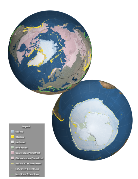
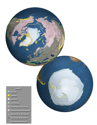
English: This high resolution image, designed for the Fifth Assessment Report of the Intergovernmental Panel on Climate Change, shows the extent of the regions affected by components of the cryosphere around the world. Over land, continuous permafrost is shown in a dark pink while discontinuous permafrost is shown in a lighter shade of pink. Over much of the northern hemisphere's land area, a semi-transparent white veil depicts the regions that are affected by snowfall at least one day during the perion 2000-2012. The bright green line along the southern border of this region shows the maximum snow extent while a black line across the North America, Europe and Asia shows the 50% snow extent line. Glaciers are shown as small golden dots in mountainous areas and in the far northern and southern latitudes. Over the water, ice shelves are shown around Antarctica along with sea ice surrounding the ice shelves. Sea ice is also shown at the North Pole. For both poles. the 30 year average sea ice extent is shown by a yellow outline. In addition, the ice sheets of Greenland and Antarctica are clearly visible.
วันที่
แหล่งที่มา
Goddard Multimedia
ผู้สร้างสรรค์
NASA/Goddard Space Flight Center Scientific Visualization Studio
{{Information |Description ={{en|1=This high resolution image, designed for the Fifth Assessment Report of the Intergovernmental Panel on Climate Change, shows the extent of the regions affected by components of the cryosphere around the world. Over...
wrong data type 7 for "RichTIFFIPTC"; tag ignored.
มกราคม 11, 2023
ไฟล, components, cryosphere, ไฟล, ประว, ไฟล, หน, าท, ภาพน, การใช, ไฟล, วนกลาง, อม, ลเก, ยวก, บภาพขนาดของต, วอย, าง, ของไฟล, กเซล, ความละเอ, ยดอ, กเซล, กเซล, กเซล, กเซล, กเซล, ภาพท, ความละเอ, ยดส, งกว, 8206, กเซล, ขนาดไฟล, เมกะไบต, ชน, ดไมม, image, tiff, ปภาพหร. ifl prawtiifl hnathimiphaphni karichiflswnklang khxmulekiywkbphaphkhnadkhxngtwxyang PNG nikhxngifl TIF ni 463 599 phikesl khwamlaexiydxun 185 240 phikesl 371 480 phikesl 593 768 phikesl 791 1 024 phikesl 2 048 2 650 phikesl duphaphthimikhwamlaexiydsungkwa 8206 2 048 2 650 phikesl khnadifl 20 91 emkaibt chnidimm image tiff rupphaphhruxiflesiyngni tnchbbxyuthi khxmmxns raylaexiyddanlang epnkhxkhwamthiaesdngphlcak ifltnchbbinkhxmmxns khxmmxnsepnewbistinokhrngkarsahrbekbrwbrwmsuxesri thi khunsamarthchwyid khwamyx khaxthibayComponents of the Cryosphere tif English This high resolution image designed for the Fifth Assessment Report of the Intergovernmental Panel on Climate Change shows the extent of the regions affected by components of the cryosphere around the world Over land continuous permafrost is shown in a dark pink while discontinuous permafrost is shown in a lighter shade of pink Over much of the northern hemisphere s land area a semi transparent white veil depicts the regions that are affected by snowfall at least one day during the perion 2000 2012 The bright green line along the southern border of this region shows the maximum snow extent while a black line across the North America Europe and Asia shows the 50 snow extent line Glaciers are shown as small golden dots in mountainous areas and in the far northern and southern latitudes Over the water ice shelves are shown around Antarctica along with sea ice surrounding the ice shelves Sea ice is also shown at the North Pole For both poles the 30 year average sea ice extent is shown by a yellow outline In addition the ice sheets of Greenland and Antarctica are clearly visible wnthi 21 phvscikayn ph s 2554aehlngthima Goddard Multimediaphusrangsrrkh NASA Goddard Space Flight Center Scientific Visualization Studio karxnuyatichsiththi Public domain Public domain false falsephaphniepnsatharnsmbti enuxngcakepnphaphthisrangkhunodyxngkhkarbriharkarbinaelaxwkasaehngchati NASA sungtamnoybaydanlikhsiththikhxngnasarabuiwwa phaphaelasuxtang khxngnasaimidrbkarkhumkhrxngodylikhsiththiykewncarabuiwwamilikhsiththi duephimthi hnanoybaydanlikhsiththikhxngnasa hrux noybaykarichphaphkhxng JPLkhaetuxn karich olokkhxngnasa ekhruxnghmayaelaekhruxngpradbkhxngnasa thukcakddwykdhmayshrthxemrikainlksna 14 khxngkhxbngkhbthangrachkarshrthxemrika swnthi 1221 ewbistkhxngnasaekbrwbrwmphaphthimacakxngkhkarxwkasosewiyt xngkhkarxwkasaehngchatirsesiy aelaxngkhkarxwkasthimiichxngkhkarxwkaskhxngshrthxemrika epncanwnmak phaphehlaniimcaepntxngepnsatharnsmbtiesmxip phaphhruxsuxthimacak klxngothrthrrsnxwkashbebil xacmilikhsiththi hakphaphhruxsuxnnimidrabuchdecnwamacak sthabnwithyasastrklxngothrthrrsnxwkas 1 phaphhruxsuxthnghmdthimacakekhruxngmuxkhxng okhrngkarsuksadwngxathityaelalmsuriya milikhsiththi karnaphaphhruxsuxcakokhrngkaripichnxkehnuxcakkarichephuxkarkhahruxephuxkarsuksa txngidrbxnuyatkxn 2 phaphthithukkhdeluxkihepn phaphdarasastrpracawn APOD bnewbistkhxng APOD xacmilikhsiththi 3 khabrryayodyyxithyephimkhabrryaythrrthdediywephuxkhyaykhwamwaiflnimixairixethmthiaesdngxyuiniflniprakxbdwywnthisrang wnkxtng21 phvscikayn 2011 prawtiifl khlikwnthi ewlaephuxduiflthipraktinkhnann wnthi ewlarupyxkhnadphuichkhwamehn pccubn21 22 3 thnwakhm 25562 048 2 650 20 91 emkaibt Originalwana Information Description en 1 This high resolution image designed for the Fifth Assessment Report of the Intergovernmental Panel on Climate Change shows the extent of the regions affected by components of the cryosphere around the world Over hnathimiphaphni hnatxipni oyngmathiphaphni himaphakh karichiflswnklang wikixuntxipniichiflni karichbn azb wikipedia org کریوسفر karichbn de wikipedia org Diskussion Kryosphare karichbn en wikipedia org Cryosphere karichbn es wikipedia org Criosfera karichbn eu wikipedia org Kriosfera karichbn he wikipedia org קריוספירה karichbn hi wikipedia org ह म न व ज ञ न ह ममण डल karichbn ja wikipedia org 雪氷圏 karichbn ky wikipedia org Kriosfera karichbn la wikipedia org Cryosphaera karichbn sr wikipedia org Kriosfera karichbn sv wikipedia org Kryosfaren karichbn vi wikipedia org Băng quyển karichbn www wikidata org Q493109 karichbn zh yue wikipedia org 冰雪圈khxmulekiywkbphaph phaphnimikhxmulephimetim sungswnihymacakklxngdicitxlhruxsaeknenxrthisamarthekbkhxmuldngklawiwrwmkbphaphid thaphaphnithukprbprungaekikhhruxepliynaeplngcakedim khxmulbangxyangcayngkhngimepliynaeplngehmuxnphaphthithukprbprungaekikhnnkhwamkwang2 048 phikeslkhwamsung2 650 phikeslrupaebbkarbibxdLZWphikeslkhxmophsichnRGBkarcdwangphaphpkticanwnkhxmophennt4canwnaethwtxstrip16khwamlaexiydaenwnxn1 200 dpikhwamlaexiydaenwtng1 200 dpikarcderiyngkhxmulrupaebbchngkisxftaewrthiichAdobe Photoshop CS5 Macintoshaekikhphaphlasud09 04 23 emsayn 2556sepssisRGBwarningwrong data type 7 for RichTIFFIPTC tag ignored ekhathungcak https th wikipedia org wiki ifl Components of the Cryosphere tif, wikipedia, วิกิ หนังสือ, หนังสือ, ห้องสมุด,