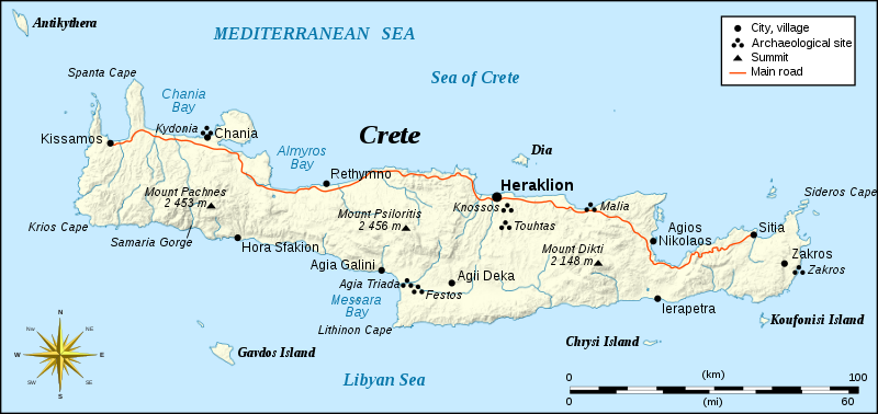
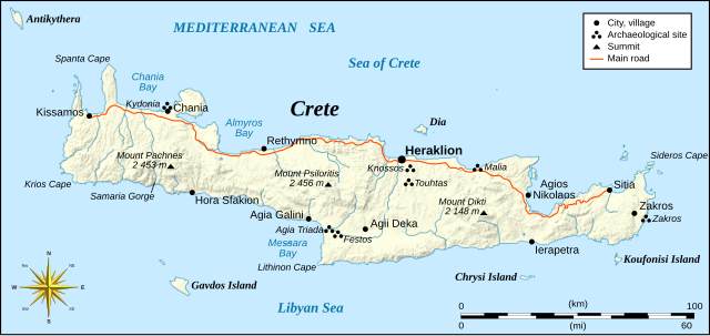
Own work, based on Image:Crete_topographic_map-fr.svg (modified and translated) created by myself ; Compass rose : Image:Brújula.svg (modified) created by Serg!o under GFDL
ผู้สร้างสรรค์
Eric Gaba (Sting)
การอนุญาต (การใช้ไฟล์นี้ใหม่)
Attribution and Share-Alike required
Any use of this map can be made as long as you credit me (Eric Gaba – Wikimedia Commons user: Sting) as the author, User:Serg!o for the compass rose, and distribute the copies and derivative works under the same license(s) that the one(s) stated below. A message with a reply address would also be greatly appreciated.
เวอร์ชันอื่น
[แก้ไข]
Topographic – SVG – French (original)
Topographic – SVG – Italian
Topographic – SVG – Russian
Topographic map of archaeological sites of Crete – SVG – Russian
Topographic – SVG – Ukranian
Topographic – raster – French
Relief (raster background) – SVG - German
Relief (raster background) – raster - German
Relief (raster background) – SVG – French (original)
This file is licensed under the Creative Commons Attribution-Share Alike 4.0 International, 3.0 Unported, 2.5 Generic, 2.0 Generic and 1.0 Generic license.
{{Location|35|20|00|N|25|00|00|E|scale:2000000}} <br/> {{Information |Description=Integrated map of Crete island, Greece |Source=Own work, based on Image:Crete_topographic_map-fr.svg (modified and translated) created by m
ไฟล, crete, integrated, ไฟล, ประว, ไฟล, หน, าท, ภาพน, การใช, ไฟล, วนกลางขนาดของต, วอย, าง, ของไฟล, กเซล, ความละเอ, ยดอ, กเซล, กเซล, กเซล, กเซล, กเซล, กเซล, ภาพท, ความละเอ, ยดส, งกว, 8206, ไฟล, กเซล, ขนาดไฟล, โลไบต, ปภาพหร, อไฟล, เส, ยงน, นฉบ, บอย, คอมมอนส, ราย. ifl prawtiifl hnathimiphaphni karichiflswnklangkhnadkhxngtwxyang PNG nikhxngifl SVG ni 800 378 phikesl khwamlaexiydxun 320 151 phikesl 640 302 phikesl 1 024 484 phikesl 1 280 604 phikesl 2 560 1 209 phikesl 900 425 phikesl duphaphthimikhwamlaexiydsungkwa 8206 ifl SVG 900 425 phikesl khnadifl 265 kiolibt rupphaphhruxiflesiyngni tnchbbxyuthi khxmmxns raylaexiyddanlang epnkhxkhwamthiaesdngphlcak ifltnchbbinkhxmmxns khxmmxnsepnewbistinokhrngkarsahrbekbrwbrwmsuxesri thi khunsamarthchwyid khwamyx taaehnngthitngklxng35 20 00 ehnux 25 00 00 tawnxxk phaphniaelaphaphxun n sthanthiediywknthi OpenStreetMap35 333333 25 000000 khaxthibayCrete integrated map en svg Integrated map of Crete island Greecewnthi thnwakhm ph s 2550aehlngthima Own work based on Image Crete topographic map fr svg modified and translated created by myself Compass rose Image Brujula svg modified created by Serg o under GFDLphusrangsrrkh Eric Gaba Sting karxnuyat karichiflniihm Attribution and Share Alike requiredAny use of this map can be made as long as you credit me Eric Gaba Wikimedia Commons user Sting as the author User Serg o for the compass rose and distribute the copies and derivative works under the same license s that the one s stated below A message with a reply address would also be greatly appreciated ewxrchnxun aekikh Topographic SVG French original Topographic SVG Italian Topographic SVG Russian Topographic map of archaeological sites of Crete SVG Russian Topographic SVG Ukranian Topographic raster FrenchRelief raster background SVG German Relief raster background raster German Relief raster background SVG French original Relief raster background SVG UkrainianArchaeological map French Archaeological map RussianOnly with shaded relief same base map English Macedonian Greek Hungarian Urdu ifl SVG nimikhxkhwamthisamarthaeplid odyichekhruxngmuxaepbphasa SVG hruxichtwaekikh SVG idkid sahrbkhxmulephimetim duthiekiywkbkaraepliflkarxnuyatichsiththi khapheca inthanaphuthuxlikhsiththikhxngphaphhruxsuxni xnuyatihichphaphhruxsuxniphayitenguxnikhtxipni xnuyatihkhdlxk aeckcayaela hruxddaeprexksarniphayitenguxnikhkhxngsyyaxnuyatexksaresrikhxngknu run 1 2 hruxrunid nbcaknithixxkodymulnithisxftaewresri odyimmiswnidhamaekikh immikhxkhwampkhnaaelapkhlng saenakhxngsyyaxnuyatrwmxyuinswnchux syyaxnuyatexksaresrikhxngknuhttp www gnu org copyleft fdl html GFDL GNU Free Documentation License true trueThis file is licensed under the Creative Commons Attribution Share Alike 4 0 International 3 0 Unported 2 5 Generic 2 0 Generic and 1 0 Generic license khunsamarth thicaaebngpn thicathasaena aeckcay aelasngngandngklawtxip thicaeriyberiyngihm thicaddaeplngngandngklaw phayitenguxnikhtxipni aesdngthima khuntxngihekiyrtiecakhxngnganxyangehmaasm odyephimlingkipyngsyyaxnuyat aelarabuhakmikarepliynaeplng khunxacthaechnniidinrupaebbidkidtamkhwr aettxngimichinlksnathiaenawaphuihxnuyatsnbsnunkhunhruxkarichngankhxngkhun xnuyataebbediywkn hakkhunddaeplng epliynrup hruxtxetimnganni khuntxngichsyyaxnuyataebbediywknhruxaebbthiehmuxnkbsyyaxnuyatthiichkbnganniethannhttps creativecommons org licenses by sa 4 0 CC BY SA 4 0 Creative Commons Attribution Share Alike 4 0 true truekhunsamartheluxksyyaxnuyatdngklawtamtxngkarkhabrryayodyyxithyephimkhabrryaythrrthdediywephuxkhyaykhwamwaiflnimixairixethmthiaesdngxyuiniflniprakxbdwysthanalikhsiththimilikhsiththisyyaxnuyatGNU Free Documentation License version 1 2 or later xngkvsCreative Commons Attribution ShareAlike 2 5 Generic xngkvsCreative Commons Attribution ShareAlike 3 0 Unported xngkvsCreative Commons Attribution ShareAlike 4 0 International xngkvsCreative Commons Attribution ShareAlike 2 0 Generic xngkvsCreative Commons Attribution ShareAlike 1 0 Generic xngkvswnthisrang wnkxtngthnwakhm 2007coordinates of the point of view xngkvs35 19 59 999 N 25 0 0 000 E prawtiifl khlikwnthi ewlaephuxduiflthipraktinkhnann wnthi ewlarupyxkhnadphuichkhwamehn pccubn03 16 7 knyayn 2551900 425 265 kiolibt StingNew standard colors 07 54 4 thnwakhm 2550900 425 278 kiolibt StingOops 07 53 4 thnwakhm 2550900 425 79 kiolibt Sting Location 35 20 00 N 25 00 00 E scale 2000000 lt br gt Information Description Integrated map of Crete island Greece Source Own work based on Image Crete topographic map fr svg modified and translated created by m hnathimiphaphni hnatxipni oyngmathiphaphni khnxssxs karichiflswnklang wikixuntxipniichiflni karichbn de wikipedia org Benutzer Ulflulfl Karten karichbn en wikipedia org Knossos Knossos modern history karichbn fa wikipedia org کنوسوس karichbn fy wikipedia org Kreta Ida Psiloritis karichbn gl wikipedia org Knossos karichbn hr wikipedia org Knos karichbn ja wikipedia org クレタ島 クノッソス karichbn rue wikipedia org Kreta karichbn ru wikipedia org Istoriya pochty i pochtovyh marok Krita karichbn simple wikipedia org Knossos karichbn sk wikipedia org Kreta karichbn sl wikipedia org Knosos Agia Triada karichbn stq wikipedia org Kreta karichbn sv wikipedia org Gavdos karichbn vi wikipedia org Knossos karichbn zh wikipedia org 克诺索斯 ekhathungcak https th wikipedia org wiki ifl Crete integrated map en svg, wikipedia, วิกิ หนังสือ, หนังสือ, ห้องสมุด,