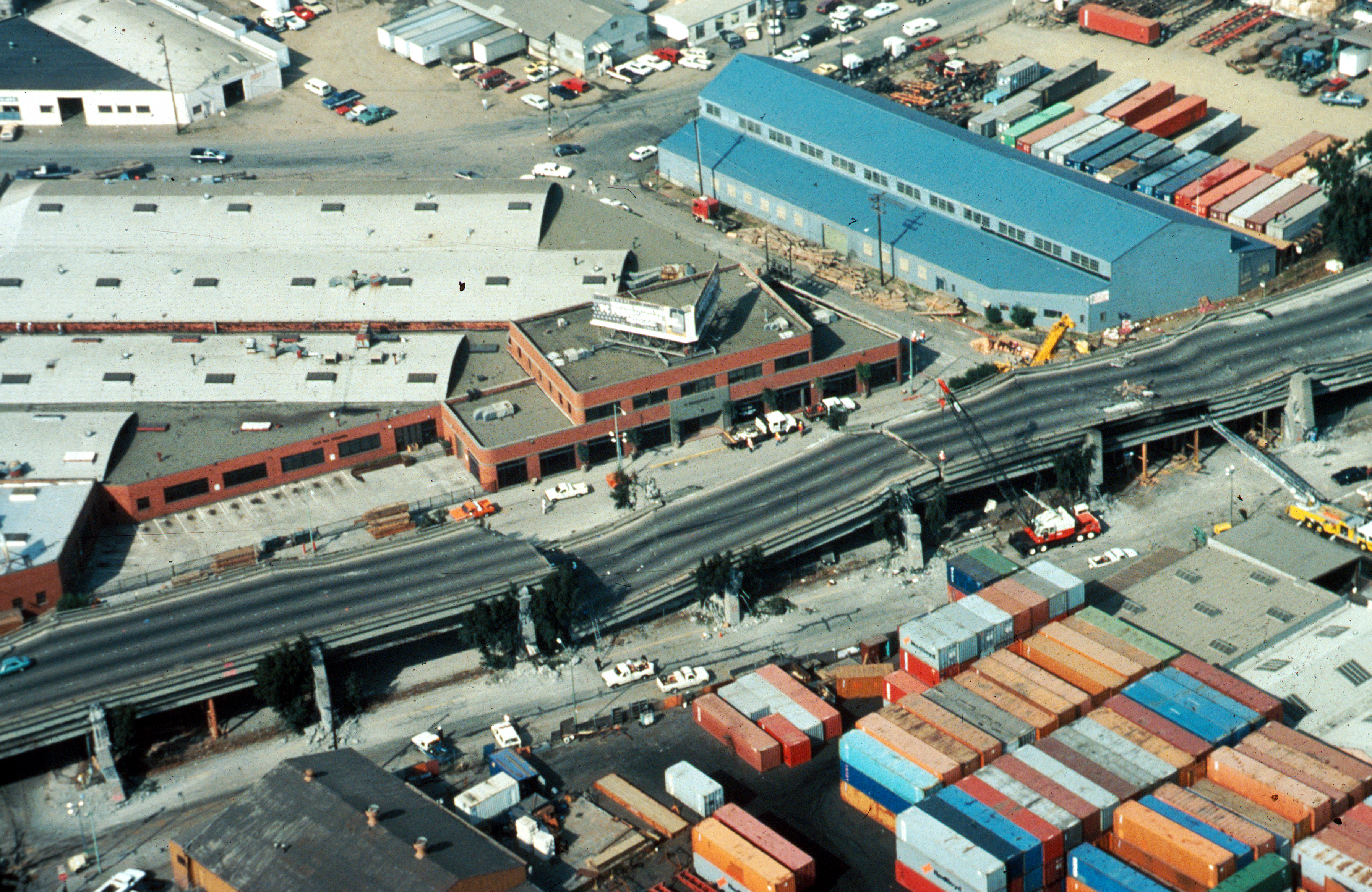
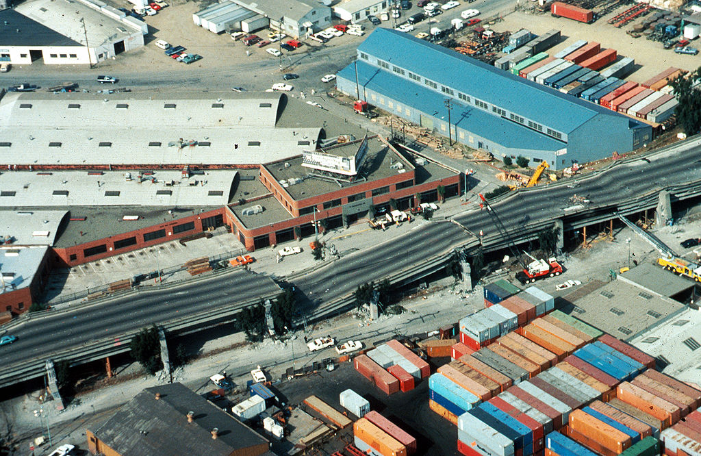
{{Information |Description=[http://wrgis.wr.usgs.gov/dds/dds-29/ USGS photo] from 1989 en:Loma Prieta earthquake. '''Caption''': Aerial view of collapsed sections of the en:Cypress Viaduct of en:Interstate 880. [H.G. Wilshire, U.S. Geolo
ไฟล, cypress, structure, jpeg, ไฟล, ประว, ไฟล, หน, าท, ภาพน, การใช, ไฟล, วนกลาง, อม, ลเก, ยวก, บภาพขนาดของต, วอย, างน, กเซล, ความละเอ, ยดอ, กเซล, กเซล, กเซล, กเซล, กเซล, กเซล, ภาพท, ความละเอ, ยดส, งกว, 8206, กเซล, ขนาดไฟล, เมกะไบต, ชน, ดไมม, image, jpeg, ปภาพห. ifl prawtiifl hnathimiphaphni karichiflswnklang khxmulekiywkbphaphkhnadkhxngtwxyangni 800 521 phikesl khwamlaexiydxun 320 208 phikesl 640 416 phikesl 1 024 666 phikesl 1 280 833 phikesl 2 560 1 666 phikesl 3 590 2 336 phikesl duphaphthimikhwamlaexiydsungkwa 8206 3 590 2 336 phikesl khnadifl 9 9 emkaibt chnidimm image jpeg rupphaphhruxiflesiyngni tnchbbxyuthi khxmmxns raylaexiyddanlang epnkhxkhwamthiaesdngphlcak ifltnchbbinkhxmmxns khxmmxnsepnewbistinokhrngkarsahrbekbrwbrwmsuxesri thi khunsamarthchwyid khwamyx khaxthibayCypress structure jpeg USGS photo from 1989 Loma Prieta earthquake Caption Aerial view of collapsed sections of the en Cypress Viaduct of en Interstate 880 H G Wilshire U S Geological Survey wnthi ph s 2532 aehlngthima Photo by H G Wilshire for U S Geological Survey High res version on line at nbsp 1 Lower resolution version Original image here http pubs usgs gov dds dds 29 web pages oakland html phusrangsrrkh H G Wilshire U S Geological Survey karxnuyat karichiflniihm PD USGOV INTERIOR USGS ewxrchnxun Cyprus Viaduct catastrophe Note lack of anti burst wrapping and lack of connection between upper and lower vertical elements karxnuyatichsiththi Public domain Public domain false false This image is in the public domain in the United States because it only contains materials that originally came from the United States Geological Survey an agency of the United States Department of the Interior For more information see the official USGS copyright policy Bahasa Indonesia nbsp catala nbsp cestina nbsp Deutsch nbsp eesti nbsp English nbsp espanol nbsp francais nbsp galego nbsp italiano nbsp Nederlands nbsp portugues nbsp polski nbsp sicilianu nbsp suomi nbsp Tiếng Việt nbsp Turkce nbsp blgarski nbsp makedonski nbsp russkij nbsp മലയ ള nbsp 한국어 nbsp 日本語 nbsp 中文 nbsp 中文 简体 nbsp 中文 繁體 nbsp العربية nbsp فارسی nbsp khabrryayodyyxithyephimkhabrryaythrrthdediywephuxkhyaykhwamwaiflnimixairixethmthiaesdngxyuiniflniprakxbdwywnthisrang wnkxtng1989 prawtiifl khlikwnthi ewlaephuxduiflthipraktinkhnann wnthi ewlarupyxkhnadphuichkhwamehn pccubn00 57 17 tulakhm 25523 590 2 336 9 9 emkaibt InfrogmationHigh res version 12 27 30 phvscikayn 2549763 512 64 kiolibt Zzyzx11 Information Description http wrgis wr usgs gov dds dds 29 USGS photo from 1989 en Loma Prieta earthquake 039 039 039 Caption 039 039 039 Aerial view of collapsed sections of the en Cypress Viaduct of en Interstate 880 H G Wilshire U S Geolo hnathimiphaphni hnatxipni oyngmathiphaphni aephndinihwolmaphriexta ph s 2532 karichiflswnklang wikixuntxipniichiflni karichbn af wikipedia org Loma Prieta aardbewing karichbn ar wikipedia org زلزال لوما بريتا karichbn azb wikipedia org اوکلند karichbn az wikipedia org Loma Priyeta zelzelesi 1989 karichbn bg wikipedia org Viadukt Mezhdushatska magistrala 880 karichbn da wikipedia org Loma Prieta jordskaelvet karichbn de wikipedia org Hohere Gewalt Loma Prieta Erdbeben 1989 karichbn de wikivoyage org San Jose Kalifornien Union City Kalifornien karichbn en wikipedia org Oakland California 1989 Loma Prieta earthquake Interstate 880 California Wikipedia Selected anniversaries October 17 MacArthur Maze Cypress Street Viaduct Portal San Francisco Bay Area Selected article Archive Seismic microzonation User Jer10 95 earthquakeprone User DiRkdARyL Wikipedia talk WikiProject Userboxes New Userboxes Archive 13 1989 in the United States Portal San Francisco Bay Area Selected article 18 karichbn es wikipedia org 1989 Terremoto de Loma Prieta Interestatal 880 karichbn fi wikipedia org Interstate 880 Teemasivu Yhdysvallat Kuvapoiminta13 karichbn he wikipedia org ויאדוקט karichbn hi wikipedia org भ कम प karichbn id wikipedia org Gempa bumi Loma Prieta 1989 karichbn it wikipedia org Terremoto di Loma Prieta del 1989 karichbn ja wikipedia org ロマ プリータ地震 karichbn ko wikipedia org 1989년 로마프리타 지진 karichbn ms wikipedia org Gempa bumi Loma Prieta 1989 karichbn pam wikipedia org Oakland California Interstate 880 karichbn pl wikipedia org Trzesienie ziemi Loma Prieta 1989 karichbn pt wikipedia org Sao Francisco California Sismo de Loma Prieta de 1989 karichbn ro wikipedia org Cutremurul din Loma Prieta 1989 karichbn ru wikipedia org San Andreas razlom Fors mazhor Zemletryasenie Loma Prieta karichbn simple wikipedia org 1989 Loma Prieta earthquake karichbn sr wikipedia org Rased San Andreas karichbn sv wikipedia org Loma Prieta skalvet 1989 karichbn tr wikipedia org 1989 Loma Prieta depremi karichbn uk wikipedia org Loma Priyeta zemletrus dukarichthwolkephimetimkhxngiflnikhxmulekiywkbphaph phaphnimikhxmulephimetim sungswnihymacakklxngdicitxlhruxsaeknenxrthisamarthekbkhxmuldngklawiwrwmkbphaphid thaphaphnithukprbprungaekikhhruxepliynaeplngcakedim khxmulbangxyangcayngkhngimepliynaeplngehmuxnphaphthithukprbprungaekikhnn error0 ekhathungcak https th wikipedia org wiki ifl Cypress structure jpeg, wikipedia, วิกิ หนังสือ, หนังสือ, ห้องสมุด,