Français : carte de l'île de la Déception avec les toponymes + la position des stations ainsi que des zones protégées
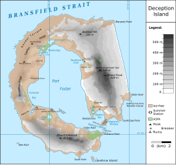
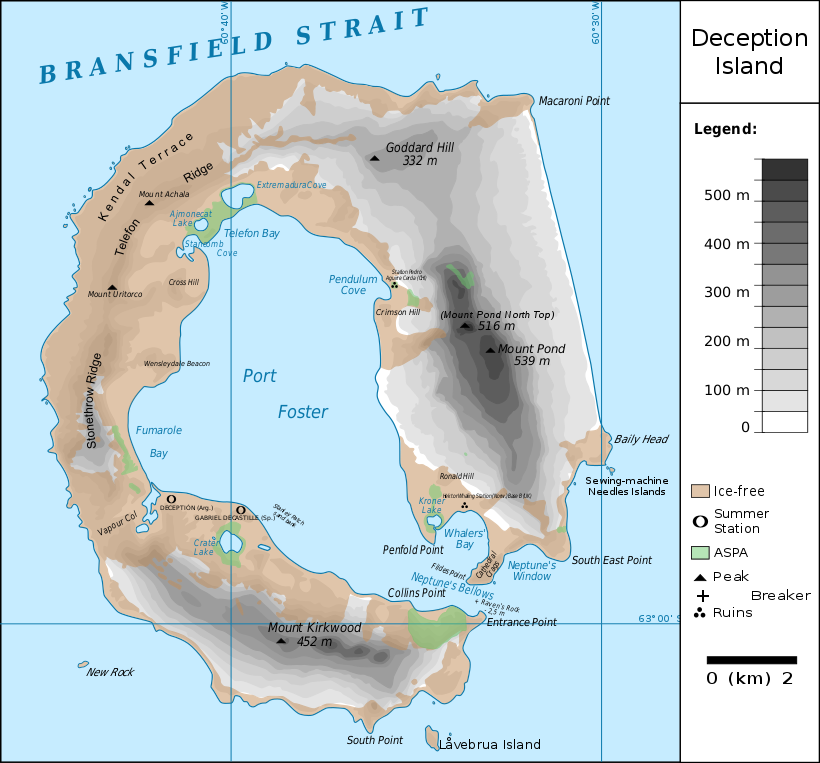
English: map of Deception Island with the topography and the location of the stations and protected zones
วันที่
(UTC)
แหล่งที่มา
Ile_de_la_Deception.svg
ผู้สร้างสรรค์
Ile_de_la_Deception.svg: Treehill
derivative work: Fitzgabbro (talk)
ภาพนี้ ได้รับการปรับแต่งภาพ ซึ่งหมายความว่าจะได้รับการเปลี่ยนแปลงภาพต่างจากต้นฉบับ ต้นฉบับสามารถดูได้ที่นี่: Ile de la Deception.svg. ปรับแต่งภาพโดย Fitzgabbro.
2010-06-18T17:48:51Z Treehill 820x763 (465569 Bytes) deux dernières légendes alignées
2010-06-18T17:30:49Z Treehill 820x763 (465601 Bytes) nom de la baie à gauche
2010-06-18T17:20:48Z Treehill 820x763 (465594 Bytes) déplacement de certains textes + 1ère tentative de suppression des carrés
2010-06-18T14:02:39Z Treehill 820x763 (465599 Bytes) {{Information |Description={{fr|1=carte de l'île de la Déception avec les toponymes + la position des stations ainsi que des zones protégées}} |Source={{own}} |Author=[[User:Treehill|Treehill]] |Date= |Permission= |other_
1.) Word "Station" no longer extends off edge of image 2.) "Peak" is spelled without a ffinal "t" 3.) "Breaker" is written in the right place instead of overwritten on "peak"
{{Information |Description={{fr|1=carte de l'île de la Déception avec les toponymes + la position des stations ainsi que des zones protégées}} {{en|1=map of Deception Island with the topography and the location of the stations and protected zones}} |S
ไฟล, deception, island, ไฟล, ประว, ไฟล, หน, าท, ภาพน, การใช, ไฟล, วนกลาง, อม, ลเก, ยวก, บภาพขนาดของต, วอย, าง, ของไฟล, กเซล, ความละเอ, ยดอ, กเซล, กเซล, กเซล, กเซล, กเซล, กเซล, ภาพท, ความละเอ, ยดส, งกว, 8206, ไฟล, กเซล, ขนาดไฟล, โลไบต, ปภาพหร, อไฟล, เส, ยงน, นฉ. ifl prawtiifl hnathimiphaphni karichiflswnklang khxmulekiywkbphaphkhnadkhxngtwxyang PNG nikhxngifl SVG ni 644 599 phikesl khwamlaexiydxun 258 240 phikesl 516 480 phikesl 825 768 phikesl 1 101 1 024 phikesl 2 201 2 048 phikesl 820 763 phikesl duphaphthimikhwamlaexiydsungkwa 8206 ifl SVG 820 763 phikesl khnadifl 461 kiolibt rupphaphhruxiflesiyngni tnchbbxyuthi khxmmxns raylaexiyddanlang epnkhxkhwamthiaesdngphlcak ifltnchbbinkhxmmxns khxmmxnsepnewbistinokhrngkarsahrbekbrwbrwmsuxesri thi khunsamarthchwyid khaxthibayDeception Island Map svg Francais carte de l ile de la Deception avec les toponymes la position des stations ainsi que des zones protegees English map of Deception Island with the topography and the location of the stations and protected zoneswnthi 9 tulakhm ph s 2553 22 09 UTC aehlngthima Ile de la Deception svgphusrangsrrkh Ile de la Deception svg Treehill derivative work Fitzgabbro talk phaphni idrbkarprbaetngphaph sunghmaykhwamwacaidrbkarepliynaeplngphaphtangcaktnchbb tnchbbsamarthduidthini Ile de la Deception svg prbaetngphaphody Fitzgabbro khapheca inthanaphuthuxlikhsiththikhxngphaphhruxsuxni xnuyatihichphaphhruxsuxniphayitenguxnikhtxipniiflnixyuphayitsyyaxnuyatkhriexthifkhxmmxns run aesdngthima 3 0 tnchbbkhunsamarth thicaaebngpn thicathasaena aeckcay aelasngngandngklawtxip thicaeriyberiyngihm thicaddaeplngngandngklaw phayitenguxnikhtxipni aesdngthima khuntxngihekiyrtiecakhxngnganxyangehmaasm odyephimlingkipyngsyyaxnuyat aelarabuhakmikarepliynaeplng khunxacthaechnniidinrupaebbidkidtamkhwr aettxngimichinlksnathiaenawaphuihxnuyatsnbsnunkhunhruxkarichngankhxngkhunhttps creativecommons org licenses by 3 0 CC BY 3 0 Creative Commons Attribution 3 0 true true xnuyatihkhdlxk aeckcayaela hruxddaeprexksarniphayitenguxnikhkhxngsyyaxnuyatexksaresrikhxngknu run 1 2 hruxrunid nbcaknithixxkodymulnithisxftaewresri odyimmiswnidhamaekikh immikhxkhwampkhnaaelapkhlng saenakhxngsyyaxnuyatrwmxyuinswnchux syyaxnuyatexksaresrikhxngknuhttp www gnu org copyleft fdl html GFDL GNU Free Documentation License true truekhunsamartheluxksyyaxnuyatdngklawtamtxngkar bnthukkarxphohld This image is a derivative work of the following images File Ile de la Deception svg licensed with Cc by 3 0 GFDL 2010 06 19T09 08 35Z Treehill 820x763 464885 Bytes carres noirs tentative 2010 06 18T17 48 51Z Treehill 820x763 465569 Bytes deux dernieres legendes alignees 2010 06 18T17 30 49Z Treehill 820x763 465601 Bytes nom de la baie a gauche 2010 06 18T17 20 48Z Treehill 820x763 465594 Bytes deplacement de certains textes 1ere tentative de suppression des carres 2010 06 18T14 02 39Z Treehill 820x763 465599 Bytes Information Description fr 1 carte de l ile de la Deception avec les toponymes la position des stations ainsi que des zones protegees Source own Author User Treehill Treehill Date Permission other Uploaded with derivativeFXkhabrryayodyyxithyephimkhabrryaythrrthdediywephuxkhyaykhwamwaiflnimixairxngkvsMap of Deception Island AntarcticaeyxrmnKarte von Deception Island AntarktissepnMapa de la Isla Decepcion AntartidafrngessCarte de l ile de la Deception AntarctiquedtchKaart van Deception Eiland AntarcticaixethmthiaesdngxyuiniflniprakxbdwysthanalikhsiththimilikhsiththisyyaxnuyatGNU Free Documentation License version 1 2 or later xngkvsCreative Commons Attribution 3 0 Unported xngkvswnthisrang wnkxtng9 tulakhm 2010MIME type xngkvsimage svg xml prawtiifl khlikwnthi ewlaephuxduiflthipraktinkhnann wnthi ewlarupyxkhnadphuichkhwamehn pccubn04 59 14 phvsphakhm 2561820 763 461 kiolibt HogweardRm duplicate 19 45 25 minakhm 2561820 763 462 kiolibt HogweardCorrected height of Pond North Top Fumarole Bay and additional names 23 35 18 knyayn 2559820 763 459 kiolibt Maproom1 Word Station no longer extends off edge of image 2 Peak is spelled without a ffinal t 3 Breaker is written in the right place instead of overwritten on peak 18 01 10 tulakhm 2553820 763 459 kiolibt FitzgabbroFixed curved writing 05 11 10 tulakhm 2553820 763 353 kiolibt Fitzgabbro Information Description fr 1 carte de l 039 ile de la Deception avec les toponymes la position des stations ainsi que des zones protegees en 1 map of Deception Island with the topography and the location of the stations and protected zones S hnathimiphaphni hnatxipni oyngmathiphaphni ekaadiespchn karichiflswnklang wikixuntxipniichiflni karichbn ceb wikipedia org Decepcion Laguna Hill Ajmonecat Lake karichbn cs wikipedia org Deception Island karichbn de wikipedia org Deception Island Mount Achala Telefon Ridge Telefon Bay Port Foster Ajmonecatsee Stancomb Cove Laguna Hill Fildes Point Neptunes Bellows Whalers Bay Penfold Point Collins Point Crater Lake Deception Island Mount Kirkwood Entrance Point Crimson Hill Kendall Terrace Kroner Lake Lavebrua Island South Point Deception Island New Rock Sudliche Shetlandinseln Mount Pond Primero de Mayo Bay Ravn Rock Ronald Hill South East Point Stonethrow Ridge Vapour Col karichbn en wikipedia org Deception Island Neptune s Bellows Sewing Machine Needles Port Foster Baily Head Wikipedia Graphics Lab Map workshop Archive 2016 Fumarole Bay karichbn eu wikipedia org Deception uhartea karichbn ja wikipedia org デセプション島 karichbn nds wikipedia org Mount Achala karichbn nl wikipedia org Deception eiland karichbn pl wikipedia org Deception Island karichbn ru wikipedia org Desepshen karichbn sv wikipedia org Deception Island karichbn tr wikipedia org Deception Adasi karichbn uk wikipedia org Desepshen Port Foster dukarichthwolkephimetimkhxngiflnikhxmulekiywkbphaph phaphnimikhxmulephimetim sungswnihymacakklxngdicitxlhruxsaeknenxrthisamarthekbkhxmuldngklawiwrwmkbphaphid thaphaphnithukprbprungaekikhhruxepliynaeplngcakedim khxmulbangxyangcayngkhngimepliynaeplngehmuxnphaphthithukprbprungaekikhnnkhwamkwang820khwamsung762 94586 ekhathungcak https th wikipedia org wiki ifl Deception Island Map svg, wikipedia, วิกิ หนังสือ, หนังสือ, ห้องสมุด,