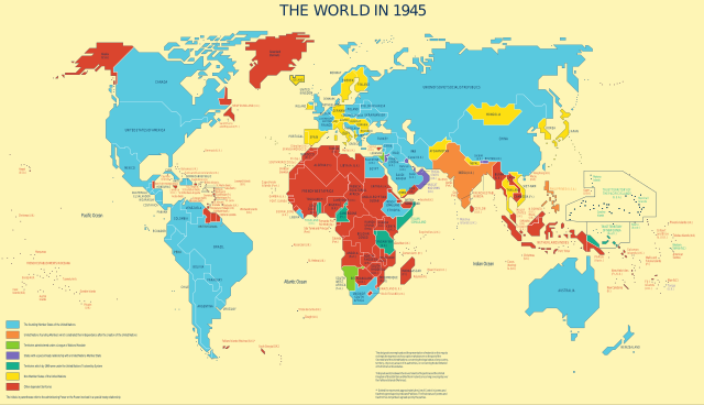
English: Map was used to show the progress of the UN's decolonization efforts.
Derivative work based on UN Map No. 4135 Rev. 3, updated in May 2010 by UN Department of Field Support, Cartographic Section
Taken from the UN's decolonization website. Only modification was a conversion to SVG and per UN license, removal of reference information from the map.
In fulfillment of a Wikipedia Graphics Lab: Map Workshop request by User:Gryffindor, referencing a photo taken by User:Deror_avi at the UN building.
English: The founding Member States of the UN
English: UN founding Members which celebrated their independence after the creation of the UN
English: Territories administered under a League of Nations Mandate
English: States with a special treaty relationship with a UN Member State
English: Territories which by 1949 were under the UN Trusteeship System
English: Non-Member States of the UN
English: Other dependent territories
วันที่
ไม่ทราบวัน
Unknown date
, last update in May 2010
แหล่งที่มา
The United Nations and Decolonization
ผู้สร้างสรรค์
United Nations Department of Field Support, Cartographic Section
Uploaded with fonts converted to paths so that WP can render text properly until it gets a better RSVG implementation - if you need to modify, use previous revision.
{{Information |Description={{en|1=Map was used to show the progress of the UN's decolonization efforts. Derivative work based on UN Map No. 4135 Rev. 3, updated in May 2010 by UN Department of Field Support, Cartographic Section Taken from the UN's deco
ไฟล, decolonization, world, 1945, ไฟล, ประว, ไฟล, หน, าท, ภาพน, การใช, ไฟล, วนกลาง, อม, ลเก, ยวก, บภาพขนาดของต, วอย, าง, ของไฟล, กเซล, ความละเอ, ยดอ, กเซล, กเซล, กเซล, กเซล, กเซล, กเซล, ภาพท, ความละเอ, ยดส, งกว, 8206, ไฟล, กเซล, ขนาดไฟล, โลไบต, ปภาพหร, อไฟล, เ. ifl prawtiifl hnathimiphaphni karichiflswnklang khxmulekiywkbphaphkhnadkhxngtwxyang PNG nikhxngifl SVG ni 800 459 phikesl khwamlaexiydxun 320 184 phikesl 640 368 phikesl 1 024 588 phikesl 1 280 735 phikesl 2 560 1 470 phikesl 1 421 816 phikesl duphaphthimikhwamlaexiydsungkwa 8206 ifl SVG 1 421 816 phikesl khnadifl 802 kiolibt rupphaphhruxiflesiyngni tnchbbxyuthi khxmmxns raylaexiyddanlang epnkhxkhwamthiaesdngphlcak ifltnchbbinkhxmmxns khxmmxnsepnewbistinokhrngkarsahrbekbrwbrwmsuxesri thi khunsamarthchwyid khwamyx khaxthibayDecolonization World In 1945 en svg English Map was used to show the progress of the UN s decolonization efforts Derivative work based on UN Map No 4135 Rev 3 updated in May 2010 by UN Department of Field Support Cartographic SectionTaken from the UN s decolonization website Only modification was a conversion to SVG and per UN license removal of reference information from the map In fulfillment of a Wikipedia Graphics Lab Map Workshop request by User Gryffindor referencing a photo taken by User Deror avi at the UN building English The founding Member States of the UN English UN founding Members which celebrated their independence after the creation of the UN English Territories administered under a League of Nations Mandate English States with a special treaty relationship with a UN Member State English Territories which by 1949 were under the UN Trusteeship System English Non Member States of the UN English Other dependent territorieswnthi imthrabwnUnknown date last update in May 2010aehlngthima The United Nations and Decolonizationphusrangsrrkh United Nations Department of Field Support Cartographic Sectionkarxnuyat karichiflniihm Public domain Public domain false falseThis image is a map derived from a United Nations map Unless stated otherwise UN maps are to be considered in the public domain This applies worldwide Some UN maps have special copyrights as indicated on the map itself UN maps are in principle open source material and you can use them in your work or for making your own map UN requests however that you delete the UN name logo and reference number upon any modification to the map Content of your map will be your responsibility You can state in your publication if you wish something like based on UN map map name map number revision number and date See The UN Cartographic Section retrieved 16 November 2013 khabrryayodyyxithyephimkhabrryaythrrthdediywephuxkhyaykhwamwaiflnimixairixethmthiaesdngxyuiniflniprakxbdwyMIME type xngkvsimage svg xml prawtiifl khlikwnthi ewlaephuxduiflthipraktinkhnann wnthi ewlarupyxkhnadphuichkhwamehn pccubn08 31 9 krkdakhm 25651 421 816 802 kiolibt KwamikagamiReverted to version as of 22 10 21 May 2012 UTC 08 29 9 krkdakhm 25651 421 816 802 kiolibt Kwamikagamiofficial UN blue 009edb 05 10 22 phvsphakhm 25551 421 816 802 kiolibt 25or6to4updated to approved font should fix location issues 03 24 13 phvsphakhm 25541 421 816 533 kiolibt Ras67frame removed 05 15 8 knyayn 25531 438 832 497 kiolibt GringerArial font some unnecessary styles removed 11 51 7 knyayn 25531 438 832 4 38 emkaibt LesqualUploaded with fonts converted to paths so that WP can render text properly until it gets a better RSVG implementation if you need to modify use previous revision 11 32 7 knyayn 25531 438 832 616 kiolibt Lesqual Information Description en 1 Map was used to show the progress of the UN 039 s decolonization efforts Derivative work based on UN Map No 4135 Rev 3 updated in May 2010 by UN Department of Field Support Cartographic Section Taken from the UN 039 s deco hnathimiphaphni hnatxipni oyngmathiphaphni dinaedninphawathrstikhxngshprachachati karichiflswnklang wikixuntxipniichiflni karichbn bg wikipedia org Svet za popechitelstvo na OON karichbn bn wikipedia org জ ত স ঘ অছ পর ষদ karichbn ca wikipedia org Consell d Administracio Fiduciaria de les Nacions Unides karichbn cy wikipedia org Hunan benderfyniad karichbn de wikipedia org UN Treuhandrat karichbn en wikipedia org Self determination United Nations Trusteeship Council Tibetan sovereignty debate Wikipedia Graphics Lab Map workshop Archive Sep 2010 Talk Annexation of Tibet by the People s Republic of China Archive 2 Wikipedia Graphics Lab Map workshop Archive May 2012 karichbn es wikipedia org Consejo de Administracion Fiduciaria de las Naciones Unidas karichbn fa wikipedia org شورای قیمومت سازمان ملل متحد karichbn fi wikipedia org Siirtomaavallan purkautuminen Yhdistyneiden kansakuntien huoltohallintoneuvosto karichbn fr wikipedia org Tibet Conseil de tutelle des Nations unies Debat sur la souverainete du Tibet Tibet 1912 1951 karichbn id wikipedia org Dewan Perwalian Perserikatan Bangsa Bangsa Perdebatan kedaulatan Tibet karichbn ko wikipedia org 유엔 신탁 통치 이사회 신탁통치령 karichbn ms wikipedia org Majlis Peramanahan Pertubuhan Bangsa Bangsa Bersatu karichbn ne wikipedia org स य क त र ष ट र ज म म जम न पर षद karichbn nl wikipedia org Trustschapsraad karichbn no wikipedia org Tilsynsomrade karichbn pa wikipedia org ਸਵ ਨ ਰਨ ਦ ਹ ਕ karichbn pt wikipedia org Debate sobre a soberania do Tibete karichbn sh wikipedia org 1945 karichbn sk wikipedia org Porucenska rada karichbn so wikipedia org Qaramada Midoobay Golaha Kalsoonida Qaramada Midoobay karichbn sv wikipedia org FN s forvaltarskapsrad karichbn ta wikipedia org ஐக க ய ந ட கள ப ற ப ப ட ச மன றம ஐக க ய ந ட கள ன ப ற ப ப ட ச கள karichbn uz wikipedia org BMT Vasiylik kengashi karichbn vi wikipedia org Hội đồng Quản thac Lien Hợp Quốc karichbn zh wikipedia org 聯合國託管理事會 自決 人權 khxmulekiywkbphaph phaphnimikhxmulephimetim sungswnihymacakklxngdicitxlhruxsaeknenxrthisamarthekbkhxmuldngklawiwrwmkbphaphid thaphaphnithukprbprungaekikhhruxepliynaeplngcakedim khxmulbangxyangcayngkhngimepliynaeplngehmuxnphaphthithukprbprungaekikhnnkhwamkwang1420 6pxkhwamsung815 7px ekhathungcak https th wikipedia org wiki ifl Decolonization World In 1945 en svg, wikipedia, วิกิ หนังสือ, หนังสือ, ห้องสมุด,