fbpx
วิกิพีเดีย

Deepwater Horizon oil spill - May 24, 2010 - with locator

ดูภาพที่มีความละเอียดสูงกว่า(2,118 × 1,628 พิกเซล, ขนาดไฟล์: 385 กิโลไบต์, ชนิดไมม์: image/jpeg)

รูปภาพหรือไฟล์เสียงนี้ ต้นฉบับอยู่ที่ คอมมอนส์ รายละเอียดด้านล่าง เป็นข้อความที่แสดงผลจาก ไฟล์ต้นฉบับในคอมมอนส์
คอมมอนส์เป็นเว็บไซต์ในโครงการสำหรับเก็บรวบรวมสื่อเสรี ที่ คุณสามารถช่วยได้

ความย่อ

 นี่คือภาพคัดสรรในวิกิพีเดียภาษาตุรกี (Seçkin resimler) และ คือ ถือว่าเป็น ภาพอย่างใดอย่างหนึ่งที่ดีที่สุด

ถ้าคิดว่าไฟล์นี้ควรจะให้ความสำคัญกับวิกิมีเดียคอมมอนส์เป็นอย่างดี อย่าลังเลที่จะ เสนอชื่อ หากคุณมีภาพที่มีคุณภาพ คล้ายคลึงกัน ที่จะสามารถเผยแพร่ได้ตาม สัญญาอนุญาตที่เหมาะสม, ให้แน่ใจว่า คุณได้ อัปโหลด กำหนดสัญญาอนุญาต และได้ เสนอชื่อแล้ว

คำอธิบาย
English: Description from NASA (source):

"NASA's Terra Satellites Sees Spill on May 24

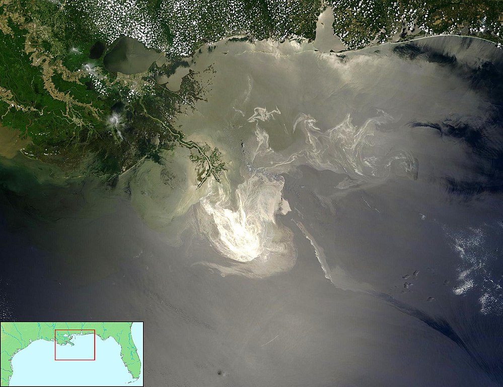
Sunlight illuminated the lingering oil slick off the Mississippi Delta on May 24, 2010. The Moderate-Resolution Imaging Spectroradiometer (MODIS) on NASA’s Terra satellite captured this image the same day.

Oil smoothes the ocean surface, making the Sun’s reflection brighter near the centerline of the path of the satellite, and reducing the scattering of sunlight in other places. As a result, the oil slick is brighter than the surrounding water in some places (image center) and darker than the surrounding water in others (image lower right). The tip of the Mississippi Delta is surrounded by muddy water that appears light tan. Bright white ribbons of oil streak across this sediment-laden water.

Tendrils of oil extend to the north and east of the main body of the slick. A small, dark plume along the edge of the slick, not far from the original location of the Deepwater Horizon rig, indicates a possible controlled burn of oil on the ocean surface.

To the west of the bird’s-foot part of the delta, dark patches in the water may also be oil, but detecting a manmade oil slick in coastal areas can be even more complicated than detecting it in the open ocean.

When oil slicks are visible in satellite images, it is because they have changed how the water reflects light, either by making the Sun’s reflection brighter or by dampening the scattering of sunlight, which makes the oily area darker. In coastal areas, however, similar changes in reflectivity can occur from differences in salinity (fresh versus salt water) and from naturally produced oils from plants.

Michon Scott NASA's Earth Observatory

NASA Goddard Space Flight Center"


Français : Traduction partielle de la description par la NASA(source):

La marée noire causée par l'incendie de la plateforme pétrolière Deepwater Horizon vue par le satellite Terra, de la NASA, le 24 mai 2010. Cette image a été acquise par le Moderate-Resolution Imaging Spectroradiometer (MODIS, pour Spectroradiomètre d'imagerie à résolution moyenne), embarqué sur le satellite Terra. Le pétrole lisse la surface de l'océan, ce qui la rend plus claire là où elle réfléchit le soleil (par exemple, au centre de la photo) et plus sombre ailleurs (par exemple en bas à droite). Le delta du Mississippi est visible en haut, entouré d'eaux saumâtres et boueuses qui apparaissent en brun, rayé de rubans argentés de pétrole.
Des dendrites de pétrole sont aussi visible au nord et à l'est. Un petit panache sombre près du centre de la marée noire, où se trouvait à l'origine la plateforme, correspond peut être à un feu contrôlé visant à la limiter.

A l'ouest de la "patte d'oiseau" que le Mississippi dessine dans le Golfe du Mexique, on peut voir des taches sombres, qui sont peut être du pétrole, ou peut être pas, car d'autres phénomènes peuvent avoir le même aspect dans ces eaux marécageuses et saumâtres.
วันที่
แหล่งที่มา 1/ File:Deepwater Horizon oil spill - May 24, 2010.jpg (based upon Original image with cropping)
2/ Locator by FT2 from File:Map of USA topological.png (Public domain by author demis.nl).
ผู้สร้างสรรค์ NASA/GSFC, MODIS Rapid Response AND demis.nl AND FT2
การอนุญาต
(การใช้ไฟล์นี้ใหม่)

Combined with other public domain source imagery.
I as compositor of these two public domain images also release my work into the public domain - FT2
เวอร์ชันอื่น

คำบรรยายโดยย่อ

เพิ่มคำบรรยายทรรทัดเดียวเพื่อขยายความว่าไฟล์นี้มีอะไร
NASA Terra Satellite image shows the extent and volume of the spill

ไอเทมที่แสดงอยู่ในไฟล์นี้

ประกอบด้วย

เหตุการณ์สำคัญ

การรั่วไหลของน้ำมันดิบจากแท่นขุดเจาะดีพวอเทอร์ฮอไรซัน

วันที่สร้าง/วันก่อตั้ง

18 มิถุนายน 2010

MIME type อังกฤษ

image/jpeg

ประวัติไฟล์

คลิกวันที่/เวลาเพื่อดูไฟล์ที่ปรากฏในขณะนั้น

วันที่/เวลารูปย่อขนาดผู้ใช้ความเห็น
ปัจจุบัน07:10, 19 มิถุนายน 25532,118 × 1,628 (385 กิโลไบต์)FT2{{Information |Description={{en|1=to add}} |Source=to add |Author=to add |Date=2010-01-01 |Permission={{PD}} |other_versions=Deepwater Horizon oil spill - May 24, 2010.jpg }}

การใช้ไฟล์ส่วนกลาง

วิกิอื่นต่อไปนี้ใช้ไฟล์นี้:

  • Екологично бедствие
  • Wikipedia:Featured picture candidates/delist/2010
  • Deepwater Horizon oil spill
  • Wikipedia:Featured picture candidates/delist/Deepwater oil spill 5-24-10
  • False equivalence
  • Environmental impact of the Deepwater Horizon oil spill
  • User:ThatGuyJabbles/sandbox
  • User:Save-The-Butter/sandbox
  • การใช้บน en.wikibooks.org
    • US History/Print version
    • US History/Obama
  • Usuario:Bsea/Cache/Secciones para Contaminación
  • Plataforma petrolífera
  • Sablon:Évfordulók/’0 és ’5/04-20
  • Kesetaraan palsu
  • Vikipedi:Günün seçkin resmi/Şubat 2012
  • Deepwater Horizon petrol sızıntısı
  • Vikipedi:Seçkin resim adayları/Deepwater Horizon oil spill - May 24, 2010 - with locator.jpg
  • Vikipedi:Seçkin resim adayları/Arşiv/Mart 2011
  • Kullanıcı:Ahzaryamed/arşiv-06.11.2010-21.04.2011
  • Şablon:GSR/2012-02-04
  • Vikipedi:Seçkin resimler/Ana sayfaya çıkmış resimler/2012 listesi
  • Vikipedi:Seçkin resimler/Ana sayfaya çıkmış resimler/2014 listesi
  • Vikipedi:Günün seçkin resmi/Mayıs 2014
  • Şablon:GSR/2014-05-13
  • Şablon:GSR/2017-03-26
  • Portal:Meksika/Seçilen resim
  • Vikipedi:Günün seçkin resmi/Mart 2017
  • ดูการใช้ทั่วโลกเพิ่มเติมของไฟล์นี้

    ข้อมูลเกี่ยวกับภาพ

    ไฟล, deepwater, horizon, spill, 2010, with, locator, ไฟล, ประว, ไฟล, หน, าท, ภาพน, การใช, ไฟล, วนกลาง, อม, ลเก, ยวก, บภาพขนาดของต, วอย, างน, กเซล, ความละเอ, ยดอ, กเซล, กเซล, กเซล, กเซล, กเซล, ภาพท, ความละเอ, ยดส, งกว, 8206, กเซล, ขนาดไฟล, โลไบต, ชน, ดไมม, imag. ifl prawtiifl hnathimiphaphni karichiflswnklang khxmulekiywkbphaphkhnadkhxngtwxyangni 780 600 phikesl khwamlaexiydxun 312 240 phikesl 625 480 phikesl 999 768 phikesl 1 280 984 phikesl 2 118 1 628 phikesl duphaphthimikhwamlaexiydsungkwa 8206 2 118 1 628 phikesl khnadifl 385 kiolibt chnidimm image jpeg rupphaphhruxiflesiyngni tnchbbxyuthi khxmmxns raylaexiyddanlang epnkhxkhwamthiaesdngphlcak ifltnchbbinkhxmmxns khxmmxnsepnewbistinokhrngkarsahrbekbrwbrwmsuxesri thi khunsamarthchwyid khwamyx nbsp nikhuxphaphkhdsrrinwikiphiediyphasaturki Seckin resimler aela khux thuxwaepn phaphxyangidxyanghnungthidithisud thakhidwaiflnikhwrcaihkhwamsakhykbwikimiediykhxmmxnsepnxyangdi xyalngelthica esnxchux hakkhunmiphaphthimikhunphaph khlaykhlungkn thicasamarthephyaephridtam syyaxnuyatthiehmaasm ihaenicwa khunid xpohld kahndsyyaxnuyat aelaid esnxchuxaelw khaxthibayDeepwater Horizon oil spill May 24 2010 with locator jpg English Description from NASA source NASA s Terra Satellites Sees Spill on May 24Sunlight illuminated the lingering oil slick off the Mississippi Delta on May 24 2010 The Moderate Resolution Imaging Spectroradiometer MODIS on NASA s Terra satellite captured this image the same day Oil smoothes the ocean surface making the Sun s reflection brighter near the centerline of the path of the satellite and reducing the scattering of sunlight in other places As a result the oil slick is brighter than the surrounding water in some places image center and darker than the surrounding water in others image lower right The tip of the Mississippi Delta is surrounded by muddy water that appears light tan Bright white ribbons of oil streak across this sediment laden water Tendrils of oil extend to the north and east of the main body of the slick A small dark plume along the edge of the slick not far from the original location of the Deepwater Horizon rig indicates a possible controlled burn of oil on the ocean surface To the west of the bird s foot part of the delta dark patches in the water may also be oil but detecting a manmade oil slick in coastal areas can be even more complicated than detecting it in the open ocean When oil slicks are visible in satellite images it is because they have changed how the water reflects light either by making the Sun s reflection brighter or by dampening the scattering of sunlight which makes the oily area darker In coastal areas however similar changes in reflectivity can occur from differences in salinity fresh versus salt water and from naturally produced oils from plants Michon Scott NASA s Earth Observatory NASA Goddard Space Flight Center Francais nbsp Traduction partielle de la description par la NASA source La maree noire causee par l incendie de la plateforme petroliere Deepwater Horizon vue par le satellite Terra de la NASA le 24 mai 2010 Cette image a ete acquise par le Moderate Resolution Imaging Spectroradiometer MODIS pour Spectroradiometre d imagerie a resolution moyenne embarque sur le satellite Terra Le petrole lisse la surface de l ocean ce qui la rend plus claire la ou elle reflechit le soleil par exemple au centre de la photo et plus sombre ailleurs par exemple en bas a droite Le delta du Mississippi est visible en haut entoure d eaux saumatres et boueuses qui apparaissent en brun raye de rubans argentes de petrole Des dendrites de petrole sont aussi visible au nord et a l est Un petit panache sombre pres du centre de la maree noire ou se trouvait a l origine la plateforme correspond peut etre a un feu controle visant a la limiter A l ouest de la patte d oiseau que le Mississippi dessine dans le Golfe du Mexique on peut voir des taches sombres qui sont peut etre du petrole ou peut etre pas car d autres phenomenes peuvent avoir le meme aspect dans ces eaux marecageuses et saumatres wnthi 18 mithunayn ph s 2553 aehlngthima 1 File Deepwater Horizon oil spill May 24 2010 jpg based upon Original image with cropping 2 Locator by FT2 from File Map of USA topological png Public domain by author demis nl phusrangsrrkh NASA GSFC MODIS Rapid Response AND demis nl AND FT2 karxnuyat karichiflniihm Public domain Public domain false false phaphniepnsatharnsmbti enuxngcakepnphaphthisrangkhunodyxngkhkarbriharkarbinaelaxwkasaehngchati NASA sungtamnoybaydanlikhsiththikhxngnasarabuiwwa phaphaelasuxtang khxngnasaimidrbkarkhumkhrxngodylikhsiththiykewncarabuiwwamilikhsiththi duephimthi hnanoybaydanlikhsiththikhxngnasa hrux noybaykarichphaphkhxng JPL khaetuxn karich olokkhxngnasa ekhruxnghmayaelaekhruxngpradbkhxngnasa thukcakddwykdhmayshrthxemrikainlksna 14 khxngkhxbngkhbthangrachkarshrthxemrika swnthi 1221 ewbistkhxngnasaekbrwbrwmphaphthimacakxngkhkarxwkasosewiyt xngkhkarxwkasaehngchatirsesiy aelaxngkhkarxwkasthimiichxngkhkarxwkaskhxngshrthxemrika epncanwnmak phaphehlaniimcaepntxngepnsatharnsmbtiesmxip phaphhruxsuxthimacak klxngothrthrrsnxwkashbebil xacmilikhsiththi hakphaphhruxsuxnnimidrabuchdecnwamacak sthabnwithyasastrklxngothrthrrsnxwkas 1 phaphhruxsuxthnghmdthimacakekhruxngmuxkhxng okhrngkarsuksadwngxathityaelalmsuriya milikhsiththi karnaphaphhruxsuxcakokhrngkaripichnxkehnuxcakkarichephuxkarkhahruxephuxkarsuksa txngidrbxnuyatkxn 2 phaphthithukkhdeluxkihepn phaphdarasastrpracawn APOD bnewbistkhxng APOD xacmilikhsiththi 3 Combined with other public domain source imagery I as compositor of these two public domain images also release my work into the public domain FT2 ewxrchnxun Original satellite imagekhabrryayodyyxithyephimkhabrryaythrrthdediywephuxkhyaykhwamwaiflnimixairxngkvsNASA Terra Satellite image shows the extent and volume of the spillixethmthiaesdngxyuiniflniprakxbdwyehtukarnsakhykarrwihlkhxngnamndibcakaethnkhudecaadiphwxethxrhxirsnwnthisrang wnkxtng18 mithunayn 2010MIME type nbsp xngkvsimage jpeg prawtiifl khlikwnthi ewlaephuxduiflthipraktinkhnann wnthi ewlarupyxkhnadphuichkhwamehn pccubn07 10 19 mithunayn 25532 118 1 628 385 kiolibt FT2 Information Description en 1 to add Source to add Author to add Date 2010 01 01 Permission PD other versions Deepwater Horizon oil spill May 24 2010 jpg hnathimiphaphni hnatxipni oyngmathiphaphni karrwihlkhxngnamndibcakaethnkhudecaadiphwxethxrhxirsn khwamsmmulethc karichiflswnklang wikixuntxipniichiflni karichbn ar wikipedia org التسرب النفطي في خليج المكسيك 2010 karichbn ast wikipedia org Contaminacion karichbn bg wikipedia org Neften razliv v Meksikanskiya zaliv Ekologichno bedstvie karichbn ca wikipedia org Falsa equivalencia karichbn de wikipedia org Geographie der Vereinigten Staaten karichbn en wikipedia org Marcia McNutt Wikipedia Featured picture candidates delist 2010 Deepwater Horizon oil spill Wikipedia Featured picture candidates delist Deepwater oil spill 5 24 10 False equivalence Environmental impact of the Deepwater Horizon oil spill User ThatGuyJabbles sandbox User Save The Butter sandbox karichbn en wikibooks org US History Print version US History Obama karichbn en wikinews org BP reports progress in oil spill cleanup karichbn en wikiquote org Barack Obama karichbn es wikipedia org Contaminacion Usuario Bsea Cache Secciones para Contaminacion Plataforma petrolifera karichbn fr wikipedia org Explosion de Deepwater Horizon karichbn gl wikipedia org Deepwater Horizon karichbn he wikipedia org דליפת הנפט במפרץ מקסיקו 2010 karichbn hu wikipedia org Wikipedia Evfordulok aprilis Sablon Evfordulok 0 es 5 04 20 karichbn it wikipedia org Disastro ambientale della piattaforma petrolifera Deepwater Horizon karichbn ja wikipedia org 2010年メキシコ湾原油流出事故 karichbn ko wikipedia org 딥워터 허라이즌 기름 유출 사고 karichbn krc wikipedia org Shablon Potd 2012 02 karichbn lv wikipedia org 2010 gada Meksikas lica naftas izpludums karichbn ml wikipedia org ഡ പ വ ട ടർ ഹ റ സൻ എണ ണച ച ർച ച karichbn ms wikipedia org Tumpahan minyak Teluk Mexico 2010 Kesetaraan palsu karichbn my wikipedia org မက ကဆ က ပင လယ က ရ န ယ ဖ တ မ ၂၀၁၀ karichbn pt wikipedia org Derramamento de oleo da Deepwater Horizon karichbn tr wikipedia org Vikipedi Seckin resimler Uzay Dunya ya bakis Vikipedi Gunun seckin resmi Subat 2012 Deepwater Horizon petrol sizintisi Vikipedi Seckin resim adaylari Deepwater Horizon oil spill May 24 2010 with locator jpg Vikipedi Seckin resim adaylari Arsiv Mart 2011 Kullanici Ahzaryamed arsiv 06 11 2010 21 04 2011 Sablon GSR 2012 02 04 Vikipedi Seckin resimler Ana sayfaya cikmis resimler 2012 listesi Vikipedi Seckin resimler Ana sayfaya cikmis resimler 2014 listesi Vikipedi Gunun seckin resmi Mayis 2014 Sablon GSR 2014 05 13 Sablon GSR 2017 03 26 Portal Meksika Secilen resim Vikipedi Gunun seckin resmi Mart 2017 dukarichthwolkephimetimkhxngiflnikhxmulekiywkbphaph phaphnimikhxmulephimetim sungswnihymacakklxngdicitxlhruxsaeknenxrthisamarthekbkhxmuldngklawiwrwmkbphaphid thaphaphnithukprbprungaekikhhruxepliynaeplngcakedim khxmulbangxyangcayngkhngimepliynaeplngehmuxnphaphthithukprbprungaekikhnn error0 ekhathungcak https th wikipedia org wiki ifl Deepwater Horizon oil spill May 24 2010 with locator jpg, wikipedia, วิกิ หนังสือ, หนังสือ, ห้องสมุด,

    บทความ

    , อ่าน, ดาวน์โหลด, ฟรี, ดาวน์โหลดฟรี, mp3, วิดีโอ, mp4, 3gp, jpg, jpeg, gif, png, รูปภาพ, เพลง, เพลง, หนัง, หนังสือ, เกม, เกม