ภาพแผนที่นี้ ควรจะถูกสร้างใหม่เป็นกราฟิกส์เวกเตอร์ ซึ่งมีข้อดีอีกหลายประการ ดูเพิ่มเติมที่คอมมอนส์:สื่อต้องการเก็บกวาดสำหรับสารสนเทศเพิ่มเติม หากภาพนี้มีในรูปแบบกราฟิกส์เวกเตอร์อยู่แล้ว กรุณาอัปโหลดและแทนที่แม่แบบนี้ด้วย {{vector version available|ชื่อภาพใหม่}} แนะนำเป็นอย่างยิ่งให้ตั้งชื่อไฟล์เวกเตอร์ใหม่นั้นในรูปแบบ "Dissolution of Austria-Hungary.svg" แล้วใส่แม่แบบ Vector version available (หรือ Vva) ซึ่งไม่ต้องใช้พารามิเตอร์ ชื่อภาพใหม่
คำอธิบายDissolution of Austria-Hungary.png
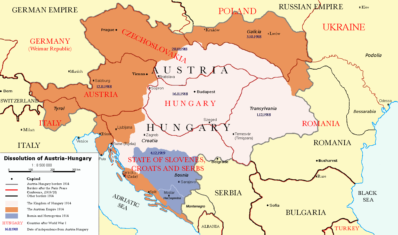
Čeština: Rozdělení Rakouska-Uherska po první světové válce, podle Pařížských předměstských smluv (Versailles s Německem, Saint-Germain-en-Laye s Rakouskem, Neuilly-sur-Seine s Bulharskem, Trianon s Maďarskem, Sèvres s Tureckem), dojednaných na Pařížské mírové konferenci (1919).
Deutsch: Das Ende Österreich-Ungarns nach den Pariser Vorortverträgen.
English: The end of Austria-Hungary after the Paris Treaty.
Border of Austria-Hungary in 1914
Borders in 1914
Borders in 1920
Austrian Empire in 1914
Kingdom of Hungary in 1914
Bosnia and Herzegovina in 1914
วันที่
(UTC)
แหล่งที่มา
Österreich-Ungarns_Ende.png
ผู้สร้างสรรค์
Österreich-Ungarns_Ende.png: AlphaCentauri / derivative work: P. S. Burton (talk)
เวอร์ชันอื่น
العربيَّة
ภาพนี้ ได้รับการปรับแต่งภาพ ซึ่งหมายความว่าจะได้รับการเปลี่ยนแปลงภาพต่างจากต้นฉบับ การปรับปรุง: translated to english. ต้นฉบับสามารถดูได้ที่นี่: Österreich-Ungarns Ende.png. ปรับแต่งภาพโดย P. S. Burton.
This image is a derivative work of the following images:
File:Österreich-Ungarns_Ende.png licensed with Cc-by-sa-3.0-migrated, GFDL
2007-07-16T11:59:46Z Nihad Hamzic 1568x970 (81916 Bytes) The original image seems to had been saved as JPEG, and that some previous uploader had simply directly converted it to PNG. I have greatly optimised its size by removing JPEG artifacts, reducing color domain, etc.
2006-01-23T20:47:06Z AlphaCentauri 1568x970 (924912 Bytes) kleine Änderungen
2005-09-23T14:27:32Z AlphaCentauri 1568x970 (924912 Bytes) Laibach and Triest
2005-09-16T09:39:55Z Kallgan 1568x970 (438065 Bytes) Das Ende Österreich-Ungarns nach dem Pariser Vorortverträgen. Selbsterstellte Karte. {{Bild-GFDL}} (Borders between Romania and Bulgaria in Dobrogea modified)(Source: Goode's World Atlas, Rand McNally & Company, 1932 & 19
Incorrectly states that Ukraine was the Russian SFSR (Russia is not seen on the map), the area of Ukraine was the Ukraine post-WW1 and later following another war, the Ukrainian Soviet Socialist Republic, and joined ...
ไฟล, dissolution, austria, hungary, ไฟล, ประว, ไฟล, หน, าท, ภาพน, การใช, ไฟล, วนกลาง, อม, ลเก, ยวก, บภาพขนาดของต, วอย, างน, กเซล, ความละเอ, ยดอ, กเซล, กเซล, กเซล, กเซล, ภาพท, ความละเอ, ยดส, งกว, 8206, กเซล, ขนาดไฟล, โลไบต, ชน, ดไมม, image, ปภาพหร, อไฟล, เส, ยง. ifl prawtiifl hnathimiphaphni karichiflswnklang khxmulekiywkbphaphkhnadkhxngtwxyangni 800 473 phikesl khwamlaexiydxun 320 189 phikesl 640 378 phikesl 1 024 605 phikesl 1 641 970 phikesl duphaphthimikhwamlaexiydsungkwa 8206 1 641 970 phikesl khnadifl 182 kiolibt chnidimm image png rupphaphhruxiflesiyngni tnchbbxyuthi khxmmxns raylaexiyddanlang epnkhxkhwamthiaesdngphlcak ifltnchbbinkhxmmxns khxmmxnsepnewbistinokhrngkarsahrbekbrwbrwmsuxesri thi khunsamarthchwyid phaphaephnthini khwrcathuksrangihmepnkrafiksewketxr sungmikhxdixikhlayprakar duephimetimthikhxmmxns suxtxngkarekbkwadsahrbsarsnethsephimetim hakphaphnimiinrupaebbkrafiksewketxrxyuaelw krunaxpohldaelaaethnthiaemaebbnidwy vector version available i chuxphaphihm i aenanaepnxyangyingihtngchuxiflewketxrihmnninrupaebb Dissolution of Austria Hungary svg aelwisaemaebb Vector version available hrux Vva sungimtxngichpharamietxr chuxphaphihm khaxthibayDissolution of Austria Hungary png Cestina Rozdeleni Rakouska Uherska po prvni svetove valce podle Parizskych predmestskych smluv Versailles s Nemeckem Saint Germain en Laye s Rakouskem Neuilly sur Seine s Bulharskem Trianon s Madarskem Sevres s Tureckem dojednanych na Parizske mirove konferenci 1919 Deutsch Das Ende Osterreich Ungarns nach den Pariser Vorortvertragen English The end of Austria Hungary after the Paris Treaty nbsp Border of Austria Hungary in 1914 nbsp Borders in 1914 nbsp Borders in 1920 nbsp Austrian Empire in 1914 nbsp Kingdom of Hungary in 1914 nbsp Bosnia and Herzegovina in 1914 wnthi 23 phvscikayn ph s 2553 21 37 UTC aehlngthima Osterreich Ungarns Ende png phusrangsrrkh Osterreich Ungarns Ende png AlphaCentauri derivative work P S Burton talk ewxrchnxun العربي ة phaphni idrbkarprbaetngphaph sunghmaykhwamwacaidrbkarepliynaeplngphaphtangcaktnchbb karprbprung translated to english tnchbbsamarthduidthini Osterreich Ungarns Ende png prbaetngphaphody P S Burton nbsp khapheca inthanaphuthuxlikhsiththikhxngphaphhruxsuxni xnuyatihichphaphhruxsuxniphayitenguxnikhtxipni iflnixyuphayitsyyaxnuyat khriexthifkhxmmxns aebbaesdngthima xnuyataebbediywkn 3 0 tnchbb khunsamarth thicaaebngpn thicathasaena aeckcay aelasngngandngklawtxip thicaeriyberiyngihm thicaddaeplngngandngklaw phayitenguxnikhtxipni aesdngthima khuntxngihekiyrtiecakhxngnganxyangehmaasm odyephimlingkipyngsyyaxnuyat aelarabuhakmikarepliynaeplng khunxacthaechnniidinrupaebbidkidtamkhwr aettxngimichinlksnathiaenawaphuihxnuyatsnbsnunkhunhruxkarichngankhxngkhun xnuyataebbediywkn hakkhunddaeplng epliynrup hruxtxetimnganni khuntxngichsyyaxnuyataebbediywknhruxaebbthiehmuxnkbsyyaxnuyatthiichkbnganniethann payaesdngsthanalikhsiththinithukephimephuxihepniptamkarepliynaeplngsyyaxnuyatkhxngmulnithiwikimiediy cak GFDL ipyng GFDL khwbkhukb CC BY SA 3 0 http creativecommons org licenses by sa 3 0 CC BY SA 3 0 Creative Commons Attribution Share Alike 3 0 true true xnuyatihkhdlxk aeckcayaela hruxddaeprexksarniphayitenguxnikhkhxngsyyaxnuyatexksaresrikhxngknu run 1 2 hruxrunid nbcaknithixxkodymulnithisxftaewresri odyimmiswnidhamaekikh immikhxkhwampkhnaaelapkhlng saenakhxngsyyaxnuyatrwmxyuinswnchux syyaxnuyatexksaresrikhxngknuhttp www gnu org copyleft fdl html GFDL GNU Free Documentation License true truekhunsamartheluxksyyaxnuyatdngklawtamtxngkar bnthukkarxphohld This image is a derivative work of the following images File Osterreich Ungarns Ende png licensed with Cc by sa 3 0 migrated GFDL 2007 07 16T11 59 46Z Nihad Hamzic 1568x970 81916 Bytes The original image seems to had been saved as JPEG and that some previous uploader had simply directly converted it to PNG I have greatly optimised its size by removing JPEG artifacts reducing color domain etc 2006 01 23T20 47 06Z AlphaCentauri 1568x970 924912 Bytes kleine Anderungen 2005 09 23T14 27 32Z AlphaCentauri 1568x970 924912 Bytes Laibach and Triest 2005 09 17T03 29 55Z Berkut 1568x970 355556 Bytes better file compression 2005 09 16T09 39 55Z Kallgan 1568x970 438065 Bytes Das Ende Osterreich Ungarns nach dem Pariser Vorortvertragen Selbsterstellte Karte Bild GFDL Borders between Romania and Bulgaria in Dobrogea modified Source Goode s World Atlas Rand McNally amp Company 1932 amp 19 2005 07 04T13 39 25Z AlphaCentauri 1568x970 924912 Bytes verbessert 2005 04 28T19 29 14Z AlphaCentauri 1568x970 924912 Bytes so nochmals verbessert 2005 04 12T18 45 25Z AlphaCentauri 1568x970 924912 Bytes nochmals verbessert 2005 04 12T15 06 42Z AlphaCentauri 1568x970 924912 Bytes 2005 04 12T14 47 08Z AlphaCentauri 1568x970 924912 Bytes verbesserte Version 2005 01 05T20 59 50Z AlphaCentauri 1568x970 924912 Bytes verbesserte Version 2004 12 29T10 14 48Z AlphaCentauri 1568x970 924912 Bytes Das Ende Osterreich Ungarns Karte Uploaded with derivativeFXkhabrryayodyyxithyephimkhabrryaythrrthdediywephuxkhyaykhwamwaiflnimixairixethmthiaesdngxyuiniflniprakxbdwydissolution of Austria Hungary nbsp xngkvsckrwrrdixxsetriy hngkariaephnthithwipyuorpswnprakxbthimikhunsmbtini bxlkhanswnprakxbthimikhunsmbtini thistawnxxkechiyngitsthanalikhsiththimilikhsiththisyyaxnuyatGNU Free Documentation License version 1 2 or later nbsp xngkvsCreative Commons Attribution ShareAlike 3 0 Unported nbsp xngkvswnthisrang wnkxtng23 phvscikayn 2010n ewla1914MIME type nbsp xngkvsimage png prawtiifl khlikwnthi ewlaephuxduiflthipraktinkhnann wnthi ewlarupyxkhnadphuichkhwamehn pccubn00 57 27 thnwakhm 25641 641 970 182 kiolibt Claude ZygielCosmetic and correct romanian ukrainian border since April 9 1918 23 27 6 thnwakhm 25631 568 970 175 kiolibt Crash48before 1919 the Greek Bulgarian border was far to the southwest 01 08 4 thnwakhm 25631 568 970 175 kiolibt Crash48Lwow didn 039 t become Lviv until 1939 23 37 2 thnwakhm 25631 568 970 148 kiolibt Crash48Romanian Ukrainian border was way off fixed according to File Romania1901 JPG 22 20 10 minakhm 25631 568 970 229 kiolibt KuflOdessa was never part of the Romania at that time 22 58 10 tulakhm 25561 568 970 163 kiolibt LvivskeIncorrectly states that Ukraine was the Russian SFSR Russia is not seen on the map the area of Ukraine was the Ukraine post WW1 and later following another war the Ukrainian Soviet Socialist Republic and joined 04 36 25 phvscikayn 25531 568 970 164 kiolibt P S BurtonUngarn gt Hungary etc 04 46 24 phvscikayn 25531 568 970 163 kiolibt P S BurtonZara gt Zara Zadar 04 41 24 phvscikayn 25531 568 970 163 kiolibt P S BurtonBlack Sea gt BLACK SEA 04 39 24 phvscikayn 25531 568 970 163 kiolibt P S Burton Information Description cs Rozdeleni Rakouska Uherska po prvni svetove valce podle Parizskych predmestskych smluv cs Versailles Ver hnathimiphaphni hnatxipni oyngmathiphaphni ckrwrrdixxsetriy hngkari snthisyyaaesng aechraemng xxng ael kh s 1919 karichiflswnklang wikixuntxipniichiflni karichbn ar wikipedia org ويكيبيديا ورشة الصور أرشيف 30 karichbn azb wikipedia org اوتریش ماجاریستان karichbn ba wikipedia org Berense donya һugyshy karichbn ca wikipedia org Alliberament de Serbia Albania i Montenegro 1918 karichbn de wikipedia org Benutzer Bergfex2011 Deutsch tschechische Grenze Jugoslawisch osterreichische Beziehungen Kroatisch osterreichische Beziehungen karichbn el wikipedia org Aystrooyggaria karichbn en wikipedia org Austria Hungary Nation state Dalmatia Aftermath of World War I Treaty of Saint Germain en Laye 1919 World War I Portal World War I Anschluss Key events of the 20th century Wikipedia Graphics Lab Map workshop Archive Dec 2010 Green Cadres Dissolution of Austria Hungary Austria victim theory User Falcaorib User Lord Milner Lord Milner Timeline User Lord Milner sandbox Lord Milner s Life Timeline karichbn fr wikipedia org Utilisateur Ludo Hongrie Diocese de Moukatcheve karichbn he wikipedia org הונגריה חוזה סן ז רמן karichbn hr wikipedia org Raspad Austro Ugarske Nastanak Kraljevstva Srba Hrvata i Slovenaca Hrvatska u Kraljevini Jugoslaviji Zenevska deklaracija 1918 karichbn hy wikipedia org Անշլյուս Առաջին համաշխարհային պատերազմի հետևանքներ karichbn id wikipedia org Austria Hungaria karichbn io wikipedia org Austria karichbn it wikipedia org Anschluss Dissoluzione dell Impero austro ungarico karichbn lmo wikipedia org Anschluss karichbn lt wikipedia org Slovenijos istorija karichbn no wikipedia org Forste verdenskrig Ettervirkningene av forste verdenskrig karichbn pnb wikipedia org آسٹریا ہنگری دی تحلیل karichbn ro wikipedia org Perioada interbelică karichbn sh wikipedia org Raspad Austro Ugarske karichbn sv wikipedia org Fredskonferensen i Paris 1919 karichbn ta wikipedia org ம தல ம உலகப ப ர karichbn ur wikipedia org آسٹریا ہنگری کی تحلیل karichbn vi wikipedia org Đế quốc Ao Hung karichbn zh wikipedia org 凡爾賽體系 dukarichthwolkephimetimkhxngiflnikhxmulekiywkbphaph phaphnimikhxmulephimetim sungswnihymacakklxngdicitxlhruxsaeknenxrthisamarthekbkhxmuldngklawiwrwmkbphaphid thaphaphnithukprbprungaekikhhruxepliynaeplngcakedim khxmulbangxyangcayngkhngimepliynaeplngehmuxnphaphthithukprbprungaekikhnnkhwamlaexiydaenwnxn37 8 dpckhwamlaexiydaenwtng37 8 dpc ekhathungcak https th wikipedia org wiki ifl Dissolution of Austria Hungary png, wikipedia, วิกิ หนังสือ, หนังสือ, ห้องสมุด,