fbpx
วิกิพีเดีย

Doris 1950 track

ดูภาพที่มีความละเอียดสูงกว่า(2,700 × 2,426 พิกเซล, ขนาดไฟล์: 590 กิโลไบต์, ชนิดไมม์: image/png)

รูปภาพหรือไฟล์เสียงนี้ ต้นฉบับอยู่ที่ คอมมอนส์ รายละเอียดด้านล่าง เป็นข้อความที่แสดงผลจาก ไฟล์ต้นฉบับในคอมมอนส์
คอมมอนส์เป็นเว็บไซต์ในโครงการสำหรับเก็บรวบรวมสื่อเสรี ที่ คุณสามารถช่วยได้

ความย่อ

คำอธิบาย
English: Track map of Typhoon Doris of the 1950 Pacific typhoon season. The points show the location of the storm at 6-hour intervals. The colour represents the storm's maximum sustained wind speeds as classified in the Saffir–Simpson scale (see below), and the shape of the data points represent the nature of the storm, according to the legend below.

Saffir–Simpson scale

 
Tropical depression (≤38 mph, ≤62 km/h)
 
Tropical storm (39–73 mph, 63–118 km/h)
 
Category 1 (74–95 mph, 119–153 km/h)
 
Category 2 (96–110 mph, 154–177 km/h)
 
Category 3 (111–129 mph, 178–208 km/h)
 
Category 4 (130–156 mph, 209–251 km/h)
 
Category 5 (≥157 mph, ≥252 km/h)
 
Unknown

Storm type

Tropical cyclone
Subtropical cyclone
Extratropical cyclone / Remnant low / Tropical disturbance / Monsoon depression
วันที่ 1950-05-06–1950-05-15
แหล่งที่มา Created by Supportstorm using WikiProject Tropical cyclones/Tracks. The background image is from NASA. Tracking data is from the International Best Track Archive for Climate Stewardship (IBTrACS)[1].
ผู้สร้างสรรค์ Supportstorm
Source code
InfoField
Track map data table, if present below, is in HURDAT2 or ATCF format. See format details in [2] and [3].
Track map generator input code
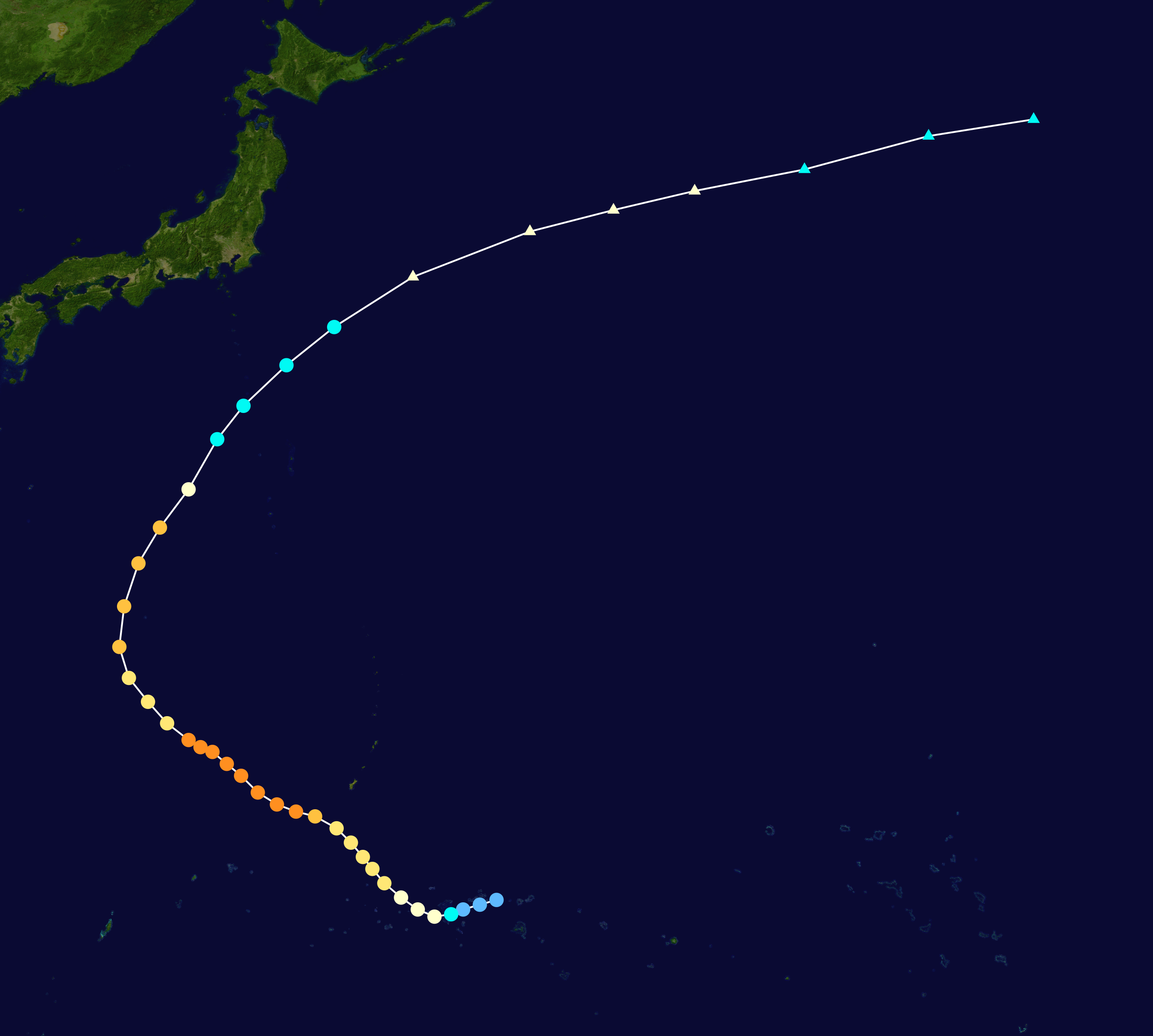
./track --id 2 --name DORIS --year 1950 --format hurdat2 --input HURDAT2 WP021950, DORIS, 40, 19500506, 0000, , TD, 8.6N, 150.8E, 30, 1000, 0, 0, 0, 0, 0, 0, 0, 0, 0, 0, 0, 0, CMA, 19500506, 0600, , TD, 8.4N, 150.1E, 30, 995, 0, 0, 0, 0, 0, 0, 0, 0, 0, 0, 0, 0, CMA, 19500506, 1200, , TD, 8.2N, 149.4E, 30, 999, 0, 0, 0, 0, 0, 0, 0, 0, 0, 0, 0, 0, CMA, 19500506, 1800, , TS, 8.0N, 148.9E, 50, 985, 0, 0, 0, 0, 0, 0, 0, 0, 0, 0, 0, 0, CMA, 19500507, 0000, , TY, 7.9N, 148.2E, 70, 971, 0, 0, 0, 0, 0, 0, 0, 0, 0, 0, 0, 0, CMA, 19500507, 0600, , TY, 8.2N, 147.5E, 75, 956, 0, 0, 0, 0, 0, 0, 0, 0, 0, 0, 0, 0, CMA, 19500507, 1200, , TY, 8.7N, 146.8E, 80, 941, 0, 0, 0, 0, 0, 0, 0, 0, 0, 0, 0, 0, CMA, 19500507, 1800, , TY, 9.3N, 146.1E, 85, 936, 0, 0, 0, 0, 0, 0, 0, 0, 0, 0, 0, 0, CMA, 19500508, 0000, , TY, 9.9N, 145.6E, 85, 930, 0, 0, 0, 0, 0, 0, 0, 0, 0, 0, 0, 0, CMA, 19500508, 0600, , TY, 10.4N, 145.2E, 85, 925, 0, 0, 0, 0, 0, 0, 0, 0, 0, 0, 0, 0, CMA, 19500508, 1200, , TY, 11.0N, 144.7E, 85, 922, 0, 0, 0, 0, 0, 0, 0, 0, 0, 0, 0, 0, CMA, 19500508, 1800, , TY, 11.6N, 144.1E, 85, 925, 0, 0, 0, 0, 0, 0, 0, 0, 0, 0, 0, 0, CMA, 19500509, 0000, , TY, 12.1N, 143.2E, 100, 929, 0, 0, 0, 0, 0, 0, 0, 0, 0, 0, 0, 0, CMA, 19500509, 0600, , TY, 12.3N, 142.4E, 115, 927, 0, 0, 0, 0, 0, 0, 0, 0, 0, 0, 0, 0, CMA, 19500509, 1200, , TY, 12.6N, 141.6E, 115, 925, 0, 0, 0, 0, 0, 0, 0, 0, 0, 0, 0, 0, CMA, 19500509, 1800, , TY, 13.1N, 140.8E, 115, 926, 0, 0, 0, 0, 0, 0, 0, 0, 0, 0, 0, 0, CMA, 19500510, 0000, , TY, 13.8N, 140.1E, 130, 927, 0, 0, 0, 0, 0, 0, 0, 0, 0, 0, 0, 0, IBTRACS, 19500510, 0600, , TY, 14.3N, 139.5E, 130, 929, 0, 0, 0, 0, 0, 0, 0, 0, 0, 0, 0, 0, IBTRACS, 19500510, 1200, , TY, 14.8N, 138.9E, 130, 930, 0, 0, 0, 0, 0, 0, 0, 0, 0, 0, 0, 0, IBTRACS, 19500510, 1800, , TY, 15.0N, 138.4E, 130, 929, 0, 0, 0, 0, 0, 0, 0, 0, 0, 0, 0, 0, JTWC, 19500511, 0000, , TY, 15.3N, 137.9E, 125, 928, 0, 0, 0, 0, 0, 0, 0, 0, 0, 0, 0, 0, IBTRACS, 19500511, 0600, , TY, 16.0N, 137.0E, 90, 929, 0, 0, 0, 0, 0, 0, 0, 0, 0, 0, 0, 0, IBTRACS, 19500511, 1200, , TY, 16.9N, 136.2E, 85, 930, 0, 0, 0, 0, 0, 0, 0, 0, 0, 0, 0, 0, IBTRACS, 19500511, 1800, , TY, 17.9N, 135.4E, 85, 935, 0, 0, 0, 0, 0, 0, 0, 0, 0, 0, 0, 0, IBTRACS, 19500512, 0000, , TY, 19.2N, 135.0E, 100, 940, 0, 0, 0, 0, 0, 0, 0, 0, 0, 0, 0, 0, IBTRACS, 19500512, 0600, , TY, 20.9N, 135.2E, 100, 945, 0, 0, 0, 0, 0, 0, 0, 0, 0, 0, 0, 0, IBTRACS, 19500512, 1200, , TY, 22.7N, 135.8E, 100, 950, 0, 0, 0, 0, 0, 0, 0, 0, 0, 0, 0, 0, IBTRACS, 19500512, 1800, , TY, 24.2N, 136.7E, 100, 952, 0, 0, 0, 0, 0, 0, 0, 0, 0, 0, 0, 0, IBTRACS, 19500513, 0000, , TY, 25.8N, 137.9E, 75, 955, 0, 0, 0, 0, 0, 0, 0, 0, 0, 0, 0, 0, CMA, 19500513, 0600, , TS, 27.9N, 139.1E, 60, 957, 0, 0, 0, 0, 0, 0, 0, 0, 0, 0, 0, 0, CMA, 19500513, 1200, , TS, 29.3N, 140.2E, 60, 960, 0, 0, 0, 0, 0, 0, 0, 0, 0, 0, 0, 0, CMA, 19500513, 1800, , TS, 31.0N, 142.0E, 60, 963, 0, 0, 0, 0, 0, 0, 0, 0, 0, 0, 0, 0, CMA, 19500514, 0000, , TS, 32.6N, 144.0E, 55, 966, 0, 0, 0, 0, 0, 0, 0, 0, 0, 0, 0, 0, CMA, 19500514, 0600, , EX, 34.7N, 147.3E, 75, 969, 0, 0, 0, 0, 0, 0, 0, 0, 0, 0, 0, 0, CMA, 19500514, 1200, , EX, 36.6N, 152.2E, 70, 975, 0, 0, 0, 0, 0, 0, 0, 0, 0, 0, 0, 0, CMA, 19500514, 1800, , EX, 37.5N, 155.7E, 70, 975, 0, 0, 0, 0, 0, 0, 0, 0, 0, 0, 0, 0, CMA, 19500515, 0000, , EX, 38.3N, 159.1E, 65, 980, 0, 0, 0, 0, 0, 0, 0, 0, 0, 0, 0, 0, CMA, 19500515, 0600, , EX, 39.2N, 163.7E, 60, 985, 0, 0, 0, 0, 0, 0, 0, 0, 0, 0, 0, 0, CMA, 19500515, 1200, , EX, 40.6N, 168.9E, 50, 990, 0, 0, 0, 0, 0, 0, 0, 0, 0, 0, 0, 0, CMA, 19500515, 1800, , EX, 41.3N, 173.3E, 50, 990, 0, 0, 0, 0, 0, 0, 0, 0, 0, 0, 0, 0, CMA, 

การอนุญาตใช้สิทธิ

คำบรรยายโดยย่อ

เพิ่มคำบรรยายทรรทัดเดียวเพื่อขยายความว่าไฟล์นี้มีอะไร

ไอเทมที่แสดงอยู่ในไฟล์นี้

ประกอบด้วย

สถานะลิขสิทธิ์

copyrighted, dedicated to the public domain by copyright holder อังกฤษ

มีลิขสิทธิ์

สัญญาอนุญาต

released into the public domain by the copyright holder อังกฤษ

ประวัติไฟล์

คลิกวันที่/เวลาเพื่อดูไฟล์ที่ปรากฏในขณะนั้น

วันที่/เวลารูปย่อขนาดผู้ใช้ความเห็น
ปัจจุบัน04:12, 21 มิถุนายน 25572,700 × 2,426 (590 กิโลไบต์)SupportstormBetter track
08:40, 29 กรกฎาคม 25562,700 × 2,420 (591 กิโลไบต์)SupportstormIBTrACS version
06:11, 28 กรกฎาคม 25531,024 × 796 (159 กิโลไบต์)Iunemade with track map generator program
23:25, 18 ตุลาคม 25511,024 × 640 (195 กิโลไบต์)Ramisses{{Information |Description=Typhoon Doris (1950) track map{{Saffir-Simpson small}} |Source=[https://metocph.nmci.navy.mil/jtwc.php JTWC]. Background image from NASA. |Author=Ramisses |Date=2008-10-18 |Permission={{PD-self}} |other_version

หน้าต่อไปนี้ โยงมาที่ภาพนี้:

การใช้ไฟล์ส่วนกลาง

วิกิอื่นต่อไปนี้ใช้ไฟล์นี้:

ไฟล, doris, 1950, track, ไฟล, ประว, ไฟล, หน, าท, ภาพน, การใช, ไฟล, วนกลางขนาดของต, วอย, างน, กเซล, ความละเอ, ยดอ, กเซล, กเซล, กเซล, กเซล, กเซล, กเซล, ภาพท, ความละเอ, ยดส, งกว, 8206, กเซล, ขนาดไฟล, โลไบต, ชน, ดไมม, image, ปภาพหร, อไฟล, เส, ยงน, นฉบ, บอย, คอมมอน. ifl prawtiifl hnathimiphaphni karichiflswnklangkhnadkhxngtwxyangni 667 599 phikesl khwamlaexiydxun 267 240 phikesl 534 480 phikesl 855 768 phikesl 1 140 1 024 phikesl 2 279 2 048 phikesl 2 700 2 426 phikesl duphaphthimikhwamlaexiydsungkwa 8206 2 700 2 426 phikesl khnadifl 590 kiolibt chnidimm image png rupphaphhruxiflesiyngni tnchbbxyuthi khxmmxns raylaexiyddanlang epnkhxkhwamthiaesdngphlcak ifltnchbbinkhxmmxns khxmmxnsepnewbistinokhrngkarsahrbekbrwbrwmsuxesri thi khunsamarthchwyid khwamyx khaxthibayDoris 1950 track png English Track map of Typhoon Doris of the 1950 Pacific typhoon season The points show the location of the storm at 6 hour intervals The colour represents the storm s maximum sustained wind speeds as classified in the Saffir Simpson scale see below and the shape of the data points represent the nature of the storm according to the legend below Saffir Simpson scale Tropical depression 38 mph 62 km h Tropical storm 39 73 mph 63 118 km h Category 1 74 95 mph 119 153 km h Category 2 96 110 mph 154 177 km h Category 3 111 129 mph 178 208 km h Category 4 130 156 mph 209 251 km h Category 5 157 mph 252 km h Unknown Storm type Tropical cyclone Subtropical cyclone Extratropical cyclone Remnant low Tropical disturbance Monsoon depressionwnthi 1950 05 06 1950 05 15aehlngthima Created by Supportstorm using WikiProject Tropical cyclones Tracks The background image is from NASA Tracking data is from the International Best Track Archive for Climate Stewardship IBTrACS 1 phusrangsrrkh SupportstormSource codeInfoFieldTrack map data table if present below is in HURDAT2 or ATCF format See format details in 2 and 3 Track map generator input code track id 2 name DORIS year 1950 format hurdat2 input HURDAT2 WP021950 DORIS 40 19500506 0000 TD 8 6N 150 8E 30 1000 0 0 0 0 0 0 0 0 0 0 0 0 CMA 19500506 0600 TD 8 4N 150 1E 30 995 0 0 0 0 0 0 0 0 0 0 0 0 CMA 19500506 1200 TD 8 2N 149 4E 30 999 0 0 0 0 0 0 0 0 0 0 0 0 CMA 19500506 1800 TS 8 0N 148 9E 50 985 0 0 0 0 0 0 0 0 0 0 0 0 CMA 19500507 0000 TY 7 9N 148 2E 70 971 0 0 0 0 0 0 0 0 0 0 0 0 CMA 19500507 0600 TY 8 2N 147 5E 75 956 0 0 0 0 0 0 0 0 0 0 0 0 CMA 19500507 1200 TY 8 7N 146 8E 80 941 0 0 0 0 0 0 0 0 0 0 0 0 CMA 19500507 1800 TY 9 3N 146 1E 85 936 0 0 0 0 0 0 0 0 0 0 0 0 CMA 19500508 0000 TY 9 9N 145 6E 85 930 0 0 0 0 0 0 0 0 0 0 0 0 CMA 19500508 0600 TY 10 4N 145 2E 85 925 0 0 0 0 0 0 0 0 0 0 0 0 CMA 19500508 1200 TY 11 0N 144 7E 85 922 0 0 0 0 0 0 0 0 0 0 0 0 CMA 19500508 1800 TY 11 6N 144 1E 85 925 0 0 0 0 0 0 0 0 0 0 0 0 CMA 19500509 0000 TY 12 1N 143 2E 100 929 0 0 0 0 0 0 0 0 0 0 0 0 CMA 19500509 0600 TY 12 3N 142 4E 115 927 0 0 0 0 0 0 0 0 0 0 0 0 CMA 19500509 1200 TY 12 6N 141 6E 115 925 0 0 0 0 0 0 0 0 0 0 0 0 CMA 19500509 1800 TY 13 1N 140 8E 115 926 0 0 0 0 0 0 0 0 0 0 0 0 CMA 19500510 0000 TY 13 8N 140 1E 130 927 0 0 0 0 0 0 0 0 0 0 0 0 IBTRACS 19500510 0600 TY 14 3N 139 5E 130 929 0 0 0 0 0 0 0 0 0 0 0 0 IBTRACS 19500510 1200 TY 14 8N 138 9E 130 930 0 0 0 0 0 0 0 0 0 0 0 0 IBTRACS 19500510 1800 TY 15 0N 138 4E 130 929 0 0 0 0 0 0 0 0 0 0 0 0 JTWC 19500511 0000 TY 15 3N 137 9E 125 928 0 0 0 0 0 0 0 0 0 0 0 0 IBTRACS 19500511 0600 TY 16 0N 137 0E 90 929 0 0 0 0 0 0 0 0 0 0 0 0 IBTRACS 19500511 1200 TY 16 9N 136 2E 85 930 0 0 0 0 0 0 0 0 0 0 0 0 IBTRACS 19500511 1800 TY 17 9N 135 4E 85 935 0 0 0 0 0 0 0 0 0 0 0 0 IBTRACS 19500512 0000 TY 19 2N 135 0E 100 940 0 0 0 0 0 0 0 0 0 0 0 0 IBTRACS 19500512 0600 TY 20 9N 135 2E 100 945 0 0 0 0 0 0 0 0 0 0 0 0 IBTRACS 19500512 1200 TY 22 7N 135 8E 100 950 0 0 0 0 0 0 0 0 0 0 0 0 IBTRACS 19500512 1800 TY 24 2N 136 7E 100 952 0 0 0 0 0 0 0 0 0 0 0 0 IBTRACS 19500513 0000 TY 25 8N 137 9E 75 955 0 0 0 0 0 0 0 0 0 0 0 0 CMA 19500513 0600 TS 27 9N 139 1E 60 957 0 0 0 0 0 0 0 0 0 0 0 0 CMA 19500513 1200 TS 29 3N 140 2E 60 960 0 0 0 0 0 0 0 0 0 0 0 0 CMA 19500513 1800 TS 31 0N 142 0E 60 963 0 0 0 0 0 0 0 0 0 0 0 0 CMA 19500514 0000 TS 32 6N 144 0E 55 966 0 0 0 0 0 0 0 0 0 0 0 0 CMA 19500514 0600 EX 34 7N 147 3E 75 969 0 0 0 0 0 0 0 0 0 0 0 0 CMA 19500514 1200 EX 36 6N 152 2E 70 975 0 0 0 0 0 0 0 0 0 0 0 0 CMA 19500514 1800 EX 37 5N 155 7E 70 975 0 0 0 0 0 0 0 0 0 0 0 0 CMA 19500515 0000 EX 38 3N 159 1E 65 980 0 0 0 0 0 0 0 0 0 0 0 0 CMA 19500515 0600 EX 39 2N 163 7E 60 985 0 0 0 0 0 0 0 0 0 0 0 0 CMA 19500515 1200 EX 40 6N 168 9E 50 990 0 0 0 0 0 0 0 0 0 0 0 0 CMA 19500515 1800 EX 41 3N 173 3E 50 990 0 0 0 0 0 0 0 0 0 0 0 0 CMA karxnuyatichsiththi Public domain Public domain false falsenganniidthukephyaephrsusatharnsmbtiodyecakhxng Supportstorm sungmiphlthwolkinbangpraeths karkrathadngklawxacimsamarththaidtamkdhmaySupportstorm xnuyatihthukkhnmisiththiinkarichiflniinthukehtuphlkarich odyimmimienguxnikh ewnaetkdhmayimxnuyatihthaechnnnkhabrryayodyyxithyephimkhabrryaythrrthdediywephuxkhyaykhwamwaiflnimixairixethmthiaesdngxyuiniflniprakxbdwysthanalikhsiththicopyrighted dedicated to the public domain by copyright holder xngkvsmilikhsiththisyyaxnuyatreleased into the public domain by the copyright holder xngkvs prawtiifl khlikwnthi ewlaephuxduiflthipraktinkhnann wnthi ewlarupyxkhnadphuichkhwamehn pccubn04 12 21 mithunayn 25572 700 2 426 590 kiolibt SupportstormBetter track 08 40 29 krkdakhm 25562 700 2 420 591 kiolibt SupportstormIBTrACS version 06 11 28 krkdakhm 25531 024 796 159 kiolibt Iunemade with track map generator program 23 25 18 tulakhm 25511 024 640 195 kiolibt Ramisses Information Description Typhoon Doris 1950 track map Saffir Simpson small Source https metocph nmci navy mil jtwc php JTWC Background image from NASA Author Ramisses Date 2008 10 18 Permission PD self other version hnathimiphaphni hnatxipni oyngmathiphaphni vduphayuitfunaepsifik ph s 2493 karichiflswnklang wikixuntxipniichiflni karichbn en wikipedia org 1950 Pacific typhoon season karichbn pt wikipedia org Temporada de tufoes no Pacifico de 1950 karichbn zh wikipedia org 1950年太平洋颱風季 ekhathungcak https th wikipedia org wiki ifl Doris 1950 track png, wikipedia, วิกิ หนังสือ, หนังสือ, ห้องสมุด,

บทความ

, อ่าน, ดาวน์โหลด, ฟรี, ดาวน์โหลดฟรี, mp3, วิดีโอ, mp4, 3gp, jpg, jpeg, gif, png, รูปภาพ, เพลง, เพลง, หนัง, หนังสือ, เกม, เกม