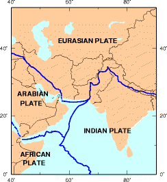
Bot: Converting file to superior PNG file. (Source: Earthquake_Information_for_Pakistan.gif). This GIF was problematic due to transparency and non-greyscale color table.
ไฟล, earthquake, information, pakistan, ไฟล, ประว, ไฟล, หน, าท, ภาพน, การใช, ไฟล, วนกลางไม, ภาพท, รายละเอ, ยดส, งกว, าน, earthquake, information, pakistan, 8206, กเซล, ขนาดไฟล, โลไบต, ชน, ดไมม, image, ปภาพหร, อไฟล, เส, ยงน, นฉบ, บอย, คอมมอนส, รายละเอ, ยดด, านล. ifl prawtiifl hnathimiphaphni karichiflswnklangimmiphaphthimiraylaexiydsungkwani Earthquake Information for Pakistan png 8206 244 266 phikesl khnadifl 10 kiolibt chnidimm image png rupphaphhruxiflesiyngni tnchbbxyuthi khxmmxns raylaexiyddanlang epnkhxkhwamthiaesdngphlcak ifltnchbbinkhxmmxns khxmmxnsepnewbistinokhrngkarsahrbekbrwbrwmsuxesri thi khunsamarthchwyid khwamyx khaxthibayEarthquake Information for Pakistan png English Earthquake information for Pakistan wnthi 28 phvsphakhm ph s 2547 13 29 31aehlngthima usgs govphusrangsrrkh Earthquake Hazards Programewxrchnxun This file has an extracted image File Earthquake Information for Pakistan es svg karxnuyatichsiththi Public domain Public domain false falseThis image is in the public domain in the United States because it only contains materials that originally came from the United States Geological Survey an agency of the United States Department of the Interior For more information see the official USGS copyright policy Bahasa Indonesia catala cestina Deutsch eesti English espanol francais galego italiano Nederlands portugues polski sicilianu suomi Tiếng Việt Turkce blgarski makedonski russkij മലയ ള 한국어 日本語 中文 中文 简体 中文 繁體 العربية فارسی bnthukkarxphohld wnthi ewla khnad phuich khwamehn22 mkrakhm ph s 2549 12 01 37 244 266 7653 bytes Mattes khuy swnrwm newkhabrryayodyyxithyephimkhabrryaythrrthdediywephuxkhyaykhwamwaiflnimixairixethmthiaesdngxyuiniflniprakxbdwywnthisrang wnkxtng28 phvsphakhm 2004MIME type xngkvsimage png prawtiifl khlikwnthi ewlaephuxduiflthipraktinkhnann wnthi ewlarupyxkhnadphuichkhwamehn pccubn23 13 6 mkrakhm 2558244 266 10 kiolibt GifTaggerBot Converting file to superior PNG file Source Earthquake Information for Pakistan gif This GIF was problematic due to transparency and non greyscale color table hnathimiphaphni hnatxipni oyngmathiphaphni aephndinihwinpraethsxfkanisthan ph s 2558 aephndinihwinaekhchemiyr ph s 2548 karichiflswnklang wikixuntxipniichiflni karichbn ar wikipedia org الصفيحة العربية صفيحة هندية karichbn arz wikipedia org جبل كوه ى سولتان karichbn az wikipedia org Iran yaylasi karichbn bn wikipedia org ভ রত য প ত ইর ন ম লভ ম karichbn bs wikipedia org Iranska visoravan karichbn ca wikipedia org Altipla Irania karichbn cs wikipedia org Zemetreseni v Kasmiru 2005 karichbn da wikipedia org Det indiske subkontinent Skabelon Infoboks jordskaelv Jordskaelvet i Kashmir 2005 Jordskaelvet i Quetta 1935 Indiske Plade Jordskaelvet i Baluchistan 1945 Jordskaelvet i Baluchistan 2008 Skabelon Infoboks jordskaelv doc karichbn de wikipedia org Iranisches Hochland Iranische Platte karichbn el wikipedia org Seismos toy Xintoy Koys Dekembrios 2015 karichbn en wikipedia org Talk Pakistan Archive 6 2005 Kashmir earthquake October 2015 Hindu Kush earthquake December 2015 Hindu Kush earthquake Koh i Sultan karichbn en wikinews org Strong earthquake hits northern Pakistan karichbn eu wikipedia org Azpikontinente karichbn fa wikipedia org فلات ایران صفحه ایران صفحه عربستان karichbn fi wikipedia org Arabian laatta karichbn hi wikipedia org अक ट बर २०१५ ह न द क श भ क प द सम बर २०१५ ह द क श भ क प २००५ कश म र भ कम प karichbn hu wikipedia org Zagrosz karichbn id wikipedia org Dataran Tinggi Iran karichbn incubator wikimedia org Wp khw جنوبی ایشیا karichbn it wikipedia org Subcontinente Altopiano iranico karichbn ja wikipedia org イランプレート karichbn ko wikipedia org 이란고원 아라비아판 이란판 karichbn mg wikipedia org Lembalemba Iraniana karichbn ml wikipedia org ഇറ ന യൻ പ ഠഭ മ karichbn nn wikipedia org Det indiske subkontinentet karichbn no wikipedia org Det indiske subkontinent Subkontinent Den indiske platen karichbn pam wikipedia org Mauling Asia dukarichthwolkephimetimkhxngiflni ekhathungcak https th wikipedia org wiki ifl Earthquake Information for Pakistan png, wikipedia, วิกิ หนังสือ, หนังสือ, ห้องสมุด,