To calculate geografic coordinates to map coordinates: X = (180 + longitude) * width of map / 360 // west is minus Y = (90 + latitude) * height of map / 360 // north is minus
การอนุญาตใช้สิทธิ
Public domainPublic domainfalsefalse
See also
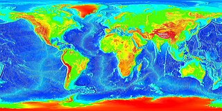
Image:LARGE elevation.jpg — a high-resolution (13MB) version of this image
Image:Earth surface NGDC 2000.jpg — made from similar data
ไฟล, elevation, ไฟล, ประว, ไฟล, หน, าท, ภาพน, การใช, ไฟล, วนกลาง, อม, ลเก, ยวก, บภาพขนาดของต, วอย, างน, กเซล, ความละเอ, ยดอ, กเซล, กเซล, กเซล, กเซล, กเซล, กเซล, ภาพท, ความละเอ, ยดส, งกว, 8206, กเซล, ขนาดไฟล, เมกะไบต, ชน, ดไมม, image, jpeg, ปภาพหร, อไฟล, เส, ยง. ifl prawtiifl hnathimiphaphni karichiflswnklang khxmulekiywkbphaphkhnadkhxngtwxyangni 800 400 phikesl khwamlaexiydxun 320 160 phikesl 640 320 phikesl 1 024 512 phikesl 1 280 640 phikesl 2 560 1 280 phikesl 10 800 5 400 phikesl duphaphthimikhwamlaexiydsungkwa 8206 10 800 5 400 phikesl khnadifl 25 61 emkaibt chnidimm image jpeg rupphaphhruxiflesiyngni tnchbbxyuthi khxmmxns raylaexiyddanlang epnkhxkhwamthiaesdngphlcak ifltnchbbinkhxmmxns khxmmxnsepnewbistinokhrngkarsahrbekbrwbrwmsuxesri thi khunsamarthchwyid khwamyx khaxthibayElevation jpg English Global land and undersea elevation flat projection Deutsch Globales Hohenprofil Flachkarte wnthi imthrabwnUnknown date aehlngthima http www ngdc noaa gov mgg image 2minrelief html phusrangsrrkh National Oceanic and Atmospheric Administration To calculate geografic coordinates to map coordinates X 180 longitude width of map 360 west is minus Y 90 latitude height of map 360 north is minus karxnuyatichsiththi Public domain Public domain false false This image is in the public domain because it contains materials that originally came from the U S National Oceanic and Atmospheric Administration taken or made as part of an employee s official duties العربية nbsp cestina nbsp Deutsch nbsp Zazaki nbsp English nbsp espanol nbsp eesti nbsp suomi nbsp francais nbsp hrvatski nbsp magyar nbsp italiano nbsp 日本語 nbsp 한국어 nbsp makedonski nbsp മലയ ള nbsp Plattduutsch nbsp Nederlands nbsp polski nbsp portugues nbsp romană nbsp russkij nbsp sicilianu nbsp slovenscina nbsp Turkce nbsp Tiếng Việt nbsp 简体中文 nbsp 繁體中文 nbsp See also Image LARGE elevation jpg a high resolution 13MB version of this image Image Earth surface NGDC 2000 jpg made from similar datakhabrryayodyyxithyephimkhabrryaythrrthdediywephuxkhyaykhwamwaiflnimixairixethmthiaesdngxyuiniflniprakxbdwyMIME type nbsp xngkvsimage jpeg prawtiifl khlikwnthi ewlaephuxduiflthipraktinkhnann wnthi ewlarupyxkhnadphuichkhwamehn pccubn03 02 20 singhakhm 256610 800 5 400 25 61 emkaibt Kersti Nebelsiekhigher resolution 06 11 14 phvscikayn 25645 400 2 700 14 08 emkaibt Antonsusiresolution 08 59 7 minakhm 25494 320 2 160 1 86 emkaibt Interiot commonswikiGlobal land and undersea elevation Source http www ngdc noaa gov mgg image 2minrelief html hnathimiphaphni hnatxipni oyngmathiphaphni knthael karichiflswnklang wikixuntxipniichiflni karichbn af wikipedia org Kontinentale plat karichbn an wikipedia org Plataforma continental karichbn ar wikipedia org قاع البحر رف قاري سمك ساحلي karichbn ast wikipedia org Plataforma continental karichbn awa wikipedia org मह द व प karichbn az wikipedia org Self karichbn ba wikipedia org Geografiya karichbn be tarask wikipedia org Shelf karichbn be wikipedia org Shelf karichbn bg wikipedia org Kontinentalen shelf Okeansko dno karichbn bh wikipedia org मह द प श ल फ karichbn br wikipedia org Plateiz kevandirel karichbn bs wikipedia org Karta svijeta Kontinentalni prag karichbn ca wikipedia org Plataforma continental karichbn ce wikipedia org Geografi karichbn ckb wikipedia org ڕەفەی کیشوەری karichbn cs wikipedia org Kontinentalni self karichbn da wikipedia org Kontinentalsokkel karichbn de wikipedia org Schelf Seven Summits Benutzer Raf dat Weltkartensammlung Benutzer Ulflulfl Karten Benutzer Casadopovo EURAFRICA karichbn el wikipedia org By8os Yfalokrhpida karichbn en wikipedia org Portal Maps Maps World Portal Maps Maps World 1 Convention on the Continental Shelf karichbn en wikiversity org Continental shelves karichbn eo wikipedia org Kontinenta drivo Kontinentbreto Konvencio pri la Kontinentbreto karichbn es wikipedia org Relieve oceanico Plataforma continental Convencion sobre la Plataforma Continental karichbn et wikipedia org Mandrilava karichbn eu wikipedia org Plataforma kontinental karichbn fa wikipedia org نقشه جهان فلات قاره بستر دریا کاربر هيربد فودازى karichbn fi wikipedia org Mannerjalusta karichbn fr wikipedia org Surpeche Wikipedia Oracle semaine 1 2007 Utilisateur Skiff A illustrer karichbn ga wikipedia org Grinneall na farraige dukarichthwolkephimetimkhxngiflnikhxmulekiywkbphaph phaphnimikhxmulephimetim sungswnihymacakklxngdicitxlhruxsaeknenxrthisamarthekbkhxmuldngklawiwrwmkbphaphid thaphaphnithukprbprungaekikhhruxepliynaeplngcakedim khxmulbangxyangcayngkhngimepliynaeplngehmuxnphaphthithukprbprungaekikhnnkhwamehnifl JPEGFile source http commons wikimedia org wiki File Atlantic bathymetry jpg ekhathungcak https th wikipedia org wiki ifl Elevation jpg, wikipedia, วิกิ หนังสือ, หนังสือ, ห้องสมุด,