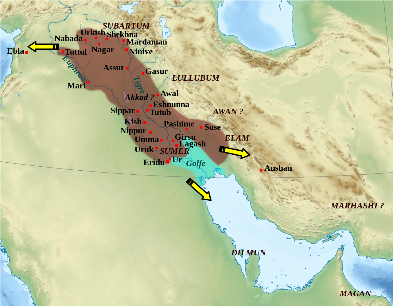
English: Map showing the approximate extension of the Akkad empire during the reign of Narâm-Sîn (2254-2218 B.C. in the short chronology).
Français : Carte de l'extension approximative de l'empire d'Akkad sous le règne de Narâm-Sîn (2254-2218 av. J.-C. selon la chronologie moyenne), et des directions des campagnes militaires extérieures.
ภาพนี้ ได้รับการปรับแต่งภาพ ซึ่งหมายความว่าจะได้รับการเปลี่ยนแปลงภาพต่างจากต้นฉบับ การปรับปรุง: Ajout des villes, du contour approximatif de l'empire.. ต้นฉบับสามารถดูได้ที่นี่: Middle East topographic map-blank.svg. ปรับแต่งภาพโดย Zunkir.
ไฟล, empire, akkad, ไฟล, ประว, ไฟล, หน, าท, ภาพน, การใช, ไฟล, วนกลาง, อม, ลเก, ยวก, บภาพขนาดของต, วอย, าง, ของไฟล, กเซล, ความละเอ, ยดอ, กเซล, กเซล, กเซล, กเซล, กเซล, กเซล, ภาพท, ความละเอ, ยดส, งกว, 8206, ไฟล, กเซล, ขนาดไฟล, เมกะไบต, ปภาพหร, อไฟล, เส, ยงน, นฉบ,. ifl prawtiifl hnathimiphaphni karichiflswnklang khxmulekiywkbphaphkhnadkhxngtwxyang PNG nikhxngifl SVG ni 770 600 phikesl khwamlaexiydxun 308 240 phikesl 616 480 phikesl 986 768 phikesl 1 280 997 phikesl 2 560 1 994 phikesl 1 475 1 149 phikesl duphaphthimikhwamlaexiydsungkwa 8206 ifl SVG 1 475 1 149 phikesl khnadifl 2 33 emkaibt rupphaphhruxiflesiyngni tnchbbxyuthi khxmmxns raylaexiyddanlang epnkhxkhwamthiaesdngphlcak ifltnchbbinkhxmmxns khxmmxnsepnewbistinokhrngkarsahrbekbrwbrwmsuxesri thi khunsamarthchwyid khwamyx ifl SVG nimikhxkhwamthisamarthaeplid odyichekhruxngmuxaepbphasa SVG hruxichtwaekikh SVG idkid sahrbkhxmulephimetim duthiekiywkbkaraeplifl iflphaphkrafiksewketxrimidrabukartrwcody W3C ni srangkhunodyich Inkscape khaxthibayEmpire akkad svg English Map showing the approximate extension of the Akkad empire during the reign of Naram Sin 2254 2218 B C in the short chronology Francais Carte de l extension approximative de l empire d Akkad sous le regne de Naram Sin 2254 2218 av J C selon la chronologie moyenne et des directions des campagnes militaires exterieures wnthi 4 phvscikayn ph s 2553 22 29 UTC aehlngthima Middle East topographic map blank svgphusrangsrrkh Middle East topographic map blank svg Semhur talk derivative work Zunkir talk ewxrchnxun العربي ة Turkish version taaehnngthitngklxng32 00 00 ehnux 47 00 00 tawnxxk phaphniaelaphaphxun n sthanthiediywknthi OpenStreetMap32 000000 47 000000 phaphni idrbkarprbaetngphaph sunghmaykhwamwacaidrbkarepliynaeplngphaphtangcaktnchbb karprbprung Ajout des villes du contour approximatif de l empire tnchbbsamarthduidthini Middle East topographic map blank svg prbaetngphaphody Zunkir karxnuyatichsiththi khapheca inthanaphuthuxlikhsiththikhxngphaphhruxsuxni xnuyatihichphaphhruxsuxniphayitenguxnikhtxipniiflnixyuphayitsyyaxnuyatkhriexthifkhxmmxns runaesdngthima xnuyataebbediywkn 3 0 tnchbb 2 5 thwip 2 0 thwip aela 1 0 thwipkhunsamarth thicaaebngpn thicathasaena aeckcay aelasngngandngklawtxip thicaeriyberiyngihm thicaddaeplngngandngklaw phayitenguxnikhtxipni aesdngthima khuntxngihekiyrtiecakhxngnganxyangehmaasm odyephimlingkipyngsyyaxnuyat aelarabuhakmikarepliynaeplng khunxacthaechnniidinrupaebbidkidtamkhwr aettxngimichinlksnathiaenawaphuihxnuyatsnbsnunkhunhruxkarichngankhxngkhun xnuyataebbediywkn hakkhunddaeplng epliynrup hruxtxetimnganni khuntxngichsyyaxnuyataebbediywknhruxaebbthiehmuxnkbsyyaxnuyatthiichkbnganniethannhttps creativecommons org licenses by sa 3 0 CC BY SA 3 0 Creative Commons Attribution Share Alike 3 0 true true xnuyatihkhdlxk aeckcayaela hruxddaeprexksarniphayitenguxnikhkhxngsyyaxnuyatexksaresrikhxngknu run 1 2 hruxrunid nbcaknithixxkodymulnithisxftaewresri odyimmiswnidhamaekikh immikhxkhwampkhnaaelapkhlng saenakhxngsyyaxnuyatrwmxyuinswnchux syyaxnuyatexksaresrikhxngknuhttp www gnu org copyleft fdl html GFDL GNU Free Documentation License true truekhunsamartheluxksyyaxnuyatdngklawtamtxngkar bnthukkarxphohld This image is a derivative work of the following images File Middle East topographic map blank svg licensed with Cc by sa 3 0 2 5 2 0 1 0 GFDL 2010 11 03T17 52 56Z Semhur 3097x1938 10510751 Bytes int filedesc Information Description Multilingual description en Blank physical map of the en Middle East Middle East fr Carte physique vierge du fr Moyen Orient Moyen Orient Source own Uploaded with derivativeFXkhabrryayodyyxithyephimkhabrryaythrrthdediywephuxkhyaykhwamwaiflnimixairixethmthiaesdngxyuiniflniprakxbdwysthanalikhsiththimilikhsiththisyyaxnuyatCreative Commons Attribution ShareAlike 3 0 Unported xngkvsCreative Commons Attribution ShareAlike 2 0 Generic xngkvsCreative Commons Attribution ShareAlike 2 5 Generic xngkvsCreative Commons Attribution ShareAlike 1 0 Generic xngkvsGNU Free Documentation License version 1 2 or later xngkvswnthisrang wnkxtng4 phvscikayn 2010coordinates of the point of view xngkvs32 N 47 Eheading xngkvs 0 xngsaMIME type xngkvsimage svg xml prawtiifl khlikwnthi ewlaephuxduiflthipraktinkhnann lasud ekasud du ihmkwa 10 ekakwa 10 10 20 50 100 250 500 wnthi ewlarupyxkhnadphuichkhwamehn pccubn18 49 29 tulakhm 25541 475 1 149 2 33 emkaibt ZunkirPolice 03 32 29 tulakhm 25541 475 1 149 2 32 emkaibt ZunkirReverted to version as of 10 06 7 January 2011 03 31 29 tulakhm 25541 475 1 149 2 33 emkaibt ZunkirPolice 17 06 7 mkrakhm 25541 475 1 149 2 32 emkaibt SemhurRemove coloured boxes 05 31 12 phvscikayn 25531 475 1 149 2 33 emkaibt ZunkirNew new try 05 13 12 phvscikayn 25531 475 1 149 2 33 emkaibt ZunkirAgain 21 13 8 phvscikayn 25531 475 1 149 2 36 emkaibt ZunkirNew version 16 43 5 phvscikayn 25531 475 1 149 2 33 emkaibt ZunkirNew try 05 41 5 phvscikayn 25531 475 1 149 2 36 emkaibt ZunkirNew try 05 33 5 phvscikayn 25531 475 1 149 2 36 emkaibt ZunkirNew version lasud ekasud du ihmkwa 10 ekakwa 10 10 20 50 100 250 500 hnathimiphaphni hnatxipni oyngmathiphaphni ckrwrrdiaexkaekhd aexkaekhd emuxng karichiflswnklang wikixuntxipniichiflni karichbn af wikipedia org Akkadiese Ryk Akkad karichbn ar wikipedia org سرجون الأكدي الإمبراطورية الأكدية ويكيبيديا ورشة الصور أرشيف 15 karichbn ast wikipedia org Imperiu acadiu karichbn azb wikipedia org آکد ایمپراتورلوغو karichbn az wikipedia org Akkad seher karichbn bg wikipedia org Akad grad karichbn bn wikipedia org আক ক দ য স ম র জ য আক ক দ য সরগন karichbn br wikipedia org Impalaeriezh Akkad Sargon Akkad karichbn bs wikipedia org Akadsko carstvo karichbn ca wikipedia org Imperi Accadi Historia de Mesopotamia karichbn ckb wikipedia org ئەکەد karichbn cs wikipedia org Akkadska rise Staroveky Orient karichbn el wikipedia org Akkadikh aytokratoria karichbn en wikipedia org Akkadian Empire Shar Kali Sharri Gutian rule in Mesopotamia Naram Sin of Akkad List of conflicts in Asia History of Mesopotamia Middle Eastern empires Rimush User RekonDog Sandbox Sargon of Akkad User RekonDog sandbox Armi Syria Akkad city User History of Persia sandbox User Monochrome Monitor Under Construction Early Assyrian period King of the Universe King of Sumer and Akkad Abalgamash User SomeGuyWhoRandomlyEdits History of Sumer User SomeGuyWhoRandomlyEdits Sumerian King List User SomeGuyWhoRandomlyEdits List of conflicts in the Near East karichbn es wikipedia org Rey del Universo karichbn et wikipedia org Sargon Akadi riik Akkadlased karichbn eu wikipedia org Mesopotamia Akadtar Inperioa karichbn fa wikipedia org اکد اکد شهر dukarichthwolkephimetimkhxngiflnikhxmulekiywkbphaph phaphnimikhxmulephimetim sungswnihymacakklxngdicitxlhruxsaeknenxrthisamarthekbkhxmuldngklawiwrwmkbphaphid thaphaphnithukprbprungaekikhhruxepliynaeplngcakedim khxmulbangxyangcayngkhngimepliynaeplngehmuxnphaphthithukprbprungaekikhnnkhwamkwang1475khwamsung1149 ekhathungcak https th wikipedia org wiki ifl Empire akkad svg, wikipedia, วิกิ หนังสือ, หนังสือ, ห้องสมุด,