รูปภาพหรือไฟล์เสียงนี้ ต้นฉบับอยู่ที่ คอมมอนส์ รายละเอียดด้านล่าง เป็นข้อความที่แสดงผลจาก ไฟล์ต้นฉบับในคอมมอนส์ คอมมอนส์เป็นเว็บไซต์ในโครงการสำหรับเก็บรวบรวมสื่อเสรี ที่ คุณสามารถช่วยได้
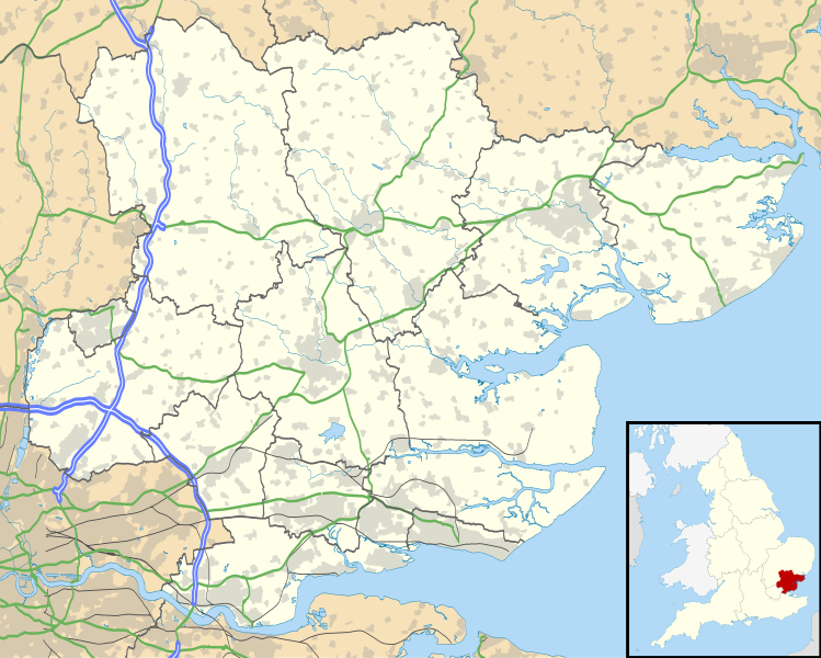
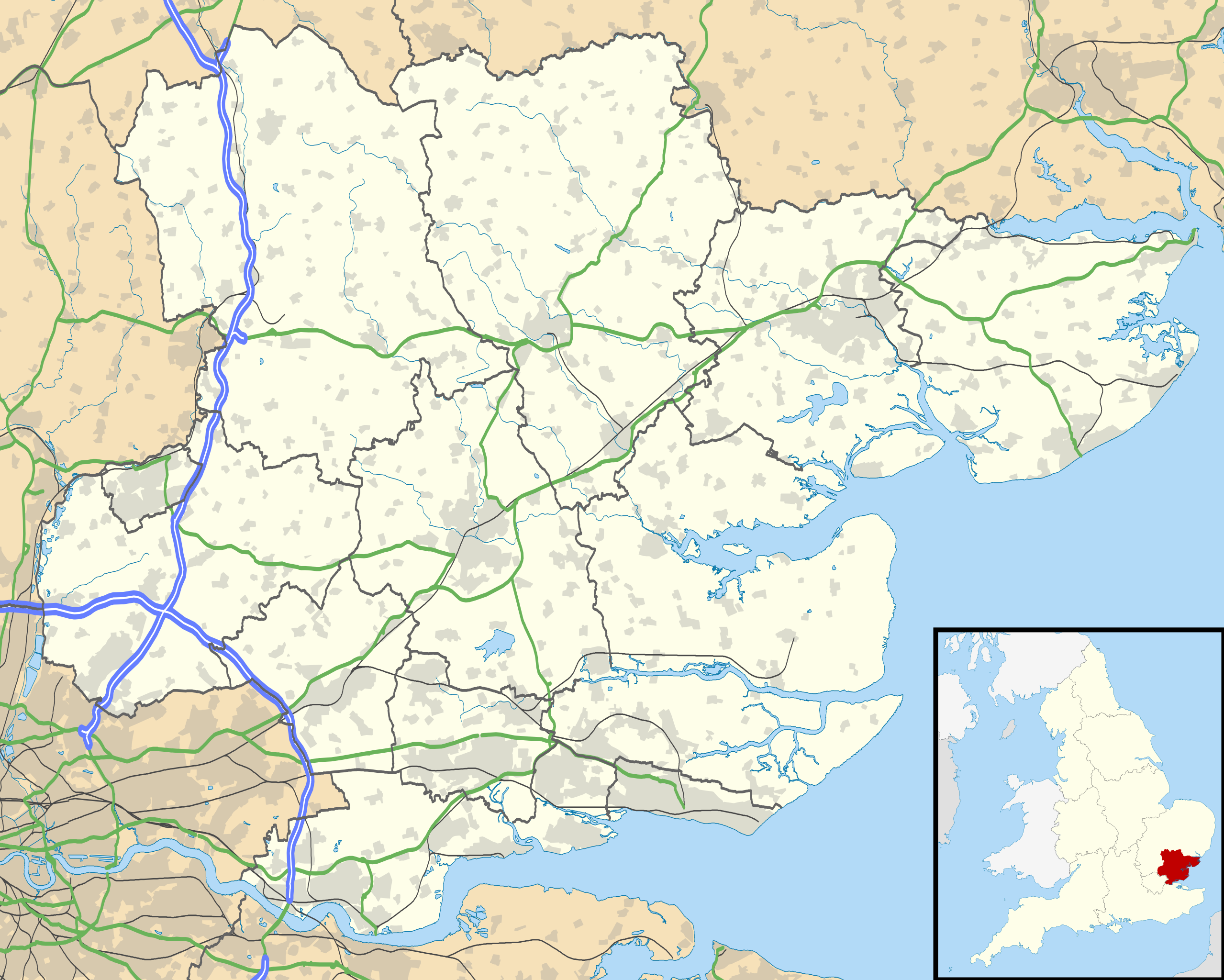
คำอธิบายEssex UK location map.svg Map of Essex, UK with the following information shown:
Administrative borders Coastline, lakes and rivers Roads and railways Urban areas Equirectangular map projection on WGS 84 datum, with N/S stretched 160%
Geographic limits:
West: 0.06W East: 1.32E North: 52.11N South: 51.42N วันที่ 26 กันยายน พ.ศ. 2553 แหล่งที่มา Ordnance Survey OpenData.
Administrative borders and coastline data from Boundary-Line product. All other geographic data from Meridian 2 product. Inset derived from England location map.svg by Spischot. ผู้สร้างสรรค์ Nilfanion, created using Ordnance Survey data การอนุญาต(การใช้ไฟล์นี้ใหม่)
ไฟล์นี้อยู่ภายใต้สัญญาอนุญาต ครีเอทีฟคอมมอนส์ แบบแสดงที่มา-อนุญาตแบบเดียวกัน 3.0 ต้นฉบับ
การแสดงที่มา: Contains Ordnance Survey data © Crown copyright and database right
คุณสามารถ: ที่จะแบ่งปัน – ที่จะทำสำเนา แจกจ่าย และส่งงานดังกล่าวต่อไปที่จะเรียบเรียงใหม่ – ที่จะดัดแปลงงานดังกล่าว ภายใต้เงื่อนไขต่อไปนี้: แสดงที่มา – คุณต้องให้เกียรติเจ้าของงานอย่างเหมาะสม โดยเพิ่มลิงก์ไปยังสัญญาอนุญาต และระบุหากมีการเปลี่ยนแปลง คุณอาจทำเช่นนี้ได้ในรูปแบบใดก็ได้ตามควร แต่ต้องไม่ใช่ในลักษณะที่แนะว่าผู้ให้อนุญาตสนับสนุนคุณหรือการใช้งานของคุณอนุญาตแบบเดียวกัน – หากคุณดัดแปลง เปลี่ยนรูป หรือต่อเติมงานนี้ คุณต้องใช้สัญญาอนุญาตแบบเดียวกันหรือแบบที่เหมือนกับสัญญาอนุญาตที่ใช้กับงานนี้เท่านั้น https://creativecommons.org/licenses/by-sa/3.0 CC BY-SA 3.0 Creative Commons Attribution-Share Alike 3.0 true true เวอร์ชันอื่น File:Essex UK district map (blank).svg - Blank map
ไทย เพิ่มคำบรรยายทรรทัดเดียวเพื่อขยายความว่าไฟล์นี้มีอะไร
ประวัติไฟล์ คลิกวันที่/เวลาเพื่อดูไฟล์ที่ปรากฏในขณะนั้น
วันที่/เวลา รูปย่อ ขนาด ผู้ใช้ ความเห็น ปัจจุบัน 01:52, 27 กันยายน 2553 1,425 × 1,141 (2.52 เมกะไบต์) Nilfanion {{Information |Description=Map of Essex, UK with the following information shown: *Administrative borders *Coastline, lakes and rivers *Roads and railways *Urban areas Equirectangular map projection on WGS 84 datum, with N/S stretched 160% G
หน้าที่มีภาพนี้ หน้าต่อไปนี้ โยงมาที่ภาพนี้:
การใช้ไฟล์ส่วนกลาง วิกิอื่นต่อไปนี้ใช้ไฟล์นี้:
Chigwell Billericay Wickford Basildon Harlow Takeley Copford Pitsea Chelmsford Southend-on-Sea Clacton-on-Sea Rochford Stanford-le-Hope Saffron Walden Thaxted Brightlingsea Burnham-on-Crouch Chalkwell Wivenhoe Dovercourt Frinton-on-Sea Manningtree Walton-on-the-Naze Westcliff-on-Sea Ingatestone Southminster Witham Coggeshall Hadleigh Southchurch Halstead Lughawe Londen-Stansted Lughawe Londen-Southend قالب:Location map United Kingdom Essex قالب:Location map United Kingdom Essex মডিউল:অবস্থান মানচিত্র/উপাত্ত/যুক্তরাজ্য এসেক্স মডিউল:অবস্থান মানচিত্র/উপাত্ত/যুক্তরাজ্য এসেক্স/নথি লন্ডন স্ট্যানস্টেড বিমানবন্দর London Southend Airport Dartford Crossing ดูการใช้ทั่วโลกเพิ่มเติม ของไฟล์นี้
ภาพนี้มีข้อมูลเพิ่มเติม ซึ่งส่วนใหญ่มาจากกล้องดิจิตอลหรือสแกนเนอร์ที่สามารถเก็บข้อมูลดังกล่าวไว้รวมกับภาพได้ ถ้าภาพนี้ถูกปรับปรุงแก้ไขหรือเปลี่ยนแปลงจากเดิม ข้อมูลบางอย่างจะยังคงไม่เปลี่ยนแปลงเหมือนภาพที่ถูกปรับปรุงแก้ไขนั้น
ไฟล, essex, location, ไฟล, ประว, ไฟล, หน, าท, ภาพน, การใช, ไฟล, วนกลาง, อม, ลเก, ยวก, บภาพขนาดของต, วอย, าง, ของไฟล, กเซล, ความละเอ, ยดอ, กเซล, กเซล, กเซล, กเซล, กเซล, กเซล, ภาพท, ความละเอ, ยดส, งกว, 8206, ไฟล, กเซล, ขนาดไฟล, เมกะไบต, ปภาพหร, อไฟล, เส, ยงน, นฉ. ifl prawtiifl hnathimiphaphni karichiflswnklang khxmulekiywkbphaphkhnadkhxngtwxyang PNG nikhxngifl SVG ni 749 600 phikesl khwamlaexiydxun 300 240 phikesl 600 480 phikesl 959 768 phikesl 1 279 1 024 phikesl 2 558 2 048 phikesl 1 425 1 141 phikesl duphaphthimikhwamlaexiydsungkwa 8206 ifl SVG 1 425 1 141 phikesl khnadifl 2 52 emkaibt rupphaphhruxiflesiyngni tnchbbxyuthi khxmmxns raylaexiyddanlang epnkhxkhwamthiaesdngphlcak ifltnchbbinkhxmmxns khxmmxnsepnewbistinokhrngkarsahrbekbrwbrwmsuxesri thi khunsamarthchwyid khaxthibayEssex UK location map svg Map of Essex UK with the following information shown Administrative borders Coastline lakes and rivers Roads and railways Urban areasEquirectangular map projection on WGS 84 datum with N S stretched 160 Geographic limits West 0 06W East 1 32E North 52 11N South 51 42Nwnthi 26 knyayn ph s 2553aehlngthima Ordnance Survey OpenData Administrative borders and coastline data from Boundary Line product All other geographic data from Meridian 2 product Inset derived from England location map svg by Spischot phusrangsrrkh Nilfanion created using Ordnance Survey datakarxnuyat karichiflniihm iflnixyuphayitsyyaxnuyat khriexthifkhxmmxns aebbaesdngthima xnuyataebbediywkn 3 0 tnchbbkaraesdngthima Contains Ordnance Survey data c Crown copyright and database rightkhunsamarth thicaaebngpn thicathasaena aeckcay aelasngngandngklawtxip thicaeriyberiyngihm thicaddaeplngngandngklaw phayitenguxnikhtxipni aesdngthima khuntxngihekiyrtiecakhxngnganxyangehmaasm odyephimlingkipyngsyyaxnuyat aelarabuhakmikarepliynaeplng khunxacthaechnniidinrupaebbidkidtamkhwr aettxngimichinlksnathiaenawaphuihxnuyatsnbsnunkhunhruxkarichngankhxngkhun xnuyataebbediywkn hakkhunddaeplng epliynrup hruxtxetimnganni khuntxngichsyyaxnuyataebbediywknhruxaebbthiehmuxnkbsyyaxnuyatthiichkbnganniethannhttps creativecommons org licenses by sa 3 0 CC BY SA 3 0 Creative Commons Attribution Share Alike 3 0 true trueewxrchnxun File Essex UK district map blank svg Blank mapkhabrryayodyyxithyephimkhabrryaythrrthdediywephuxkhyaykhwamwaiflnimixairixethmthiaesdngxyuiniflniprakxbdwysthanalikhsiththimilikhsiththisyyaxnuyatCreative Commons Attribution ShareAlike 3 0 Unported xngkvswnthisrang wnkxtng26 knyayn 2010 prawtiifl khlikwnthi ewlaephuxduiflthipraktinkhnann wnthi ewlarupyxkhnadphuichkhwamehn pccubn01 52 27 knyayn 25531 425 1 141 2 52 emkaibt Nilfanion Information Description Map of Essex UK with the following information shown Administrative borders Coastline lakes and rivers Roads and railways Urban areas Equirectangular map projection on WGS 84 datum with N S stretched 160 G hnathimiphaphni hnatxipni oyngmathiphaphni echlmsfxrd okhlechsetxr aemaebb Location map United Kingdom Essex mxdul Location map data United Kingdom Essex mxdul Location map data United Kingdom Essex doc karichiflswnklang wikixuntxipniichiflni karichbn af wikipedia org Noak Bridge Chigwell Billericay Wickford Basildon Harlow Takeley Copford Pitsea Chelmsford Southend on Sea Clacton on Sea Rochford Stanford le Hope Saffron Walden Thaxted Brightlingsea Burnham on Crouch Chalkwell Wivenhoe Dovercourt Frinton on Sea Manningtree Walton on the Naze Westcliff on Sea Ingatestone Southminster Witham Coggeshall Hadleigh Southchurch Halstead Lughawe Londen Stansted Lughawe Londen Southend karichbn ar wikipedia org إسكس قالب Location map United Kingdom Essex karichbn arz wikipedia org مطار لندن ستانستيد قالب Location map United Kingdom Essex karichbn bg wikipedia org Shablon PK Velikobritaniya Eseks karichbn bn wikipedia org লন ডন স উথএন ড ব ম নবন দর মড উল অবস থ ন ম নচ ত র উপ ত ত য ক তর জ য এস ক স মড উল অবস থ ন ম নচ ত র উপ ত ত য ক তর জ য এস ক স নথ লন ডন স ট য নস ট ড ব ম নবন দর karichbn ca wikipedia org Batalla de Camulodunum karichbn ceb wikipedia org Plantilya Location map United Kingdom Essex London Southend Airport karichbn de wikipedia org Moreton Essex karichbn el wikipedia org Protypo Location map Hnwmeno Basileio Esse3 karichbn en wikipedia org Harwich Dartford Crossing dukarichthwolkephimetimkhxngiflnikhxmulekiywkbphaph phaphnimikhxmulephimetim sungswnihymacakklxngdicitxlhruxsaeknenxrthisamarthekbkhxmuldngklawiwrwmkbphaphid thaphaphnithukprbprungaekikhhruxepliynaeplngcakedim khxmulbangxyangcayngkhngimepliynaeplngehmuxnphaphthithukprbprungaekikhnnkhwamkwang1425khwamsung1141 ekhathungcak https th wikipedia org wiki ifl Essex UK location map svg, wikipedia, วิกิ หนังสือ, หนังสือ, ห้องสมุด,
บทความ , อ่าน, ดาวน์โหลด, ฟรี, ดาวน์โหลดฟรี, mp3, วิดีโอ, mp4, 3gp, jpg, jpeg, gif, png, รูปภาพ, เพลง, เพลง, หนัง, หนังสือ, เกม, เกม