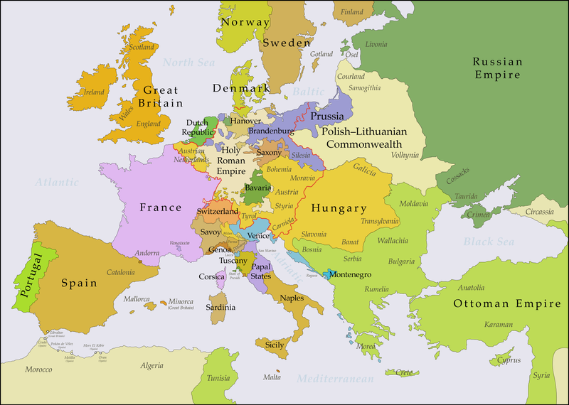
English: This map shows Europe in the years between the 1783 Russian annexation of Crimea after the Russo-Turkish War of 1768–1774 and the Russian annexation of Yedisan in 1792 at the end of the Russo-Turkish War of 1787–1792. The red line marks the borders of the Holy Roman Empire. The work was created with Inkscape and is mainly based on a map in: Putzger - Historischer Weltatlas, Berlin 1990, 78 pp.
Transferred control of Saaremaa and Hiiumaa to Russia (1721 Treaty of Nystad), transferred control of Corsica to France (1769 [[:en:French conquest of Corsica|French conquest of...
ไฟล, europe, 1783, 1792, ไฟล, ประว, ไฟล, หน, าท, ภาพน, การใช, ไฟล, วนกลาง, อม, ลเก, ยวก, บภาพขนาดของต, วอย, างน, กเซล, ความละเอ, ยดอ, กเซล, กเซล, กเซล, กเซล, กเซล, กเซล, ภาพท, ความละเอ, ยดส, งกว, 8206, กเซล, ขนาดไฟล, เมกะไบต, ชน, ดไมม, image, ปภาพหร, อไฟล, เส,. ifl prawtiifl hnathimiphaphni karichiflswnklang khxmulekiywkbphaphkhnadkhxngtwxyangni 800 570 phikesl khwamlaexiydxun 320 228 phikesl 640 456 phikesl 1 024 730 phikesl 1 280 913 phikesl 2 560 1 825 phikesl 3 872 2 761 phikesl duphaphthimikhwamlaexiydsungkwa 8206 3 872 2 761 phikesl khnadifl 1 24 emkaibt chnidimm image png rupphaphhruxiflesiyngni tnchbbxyuthi khxmmxns raylaexiyddanlang epnkhxkhwamthiaesdngphlcak ifltnchbbinkhxmmxns khxmmxnsepnewbistinokhrngkarsahrbekbrwbrwmsuxesri thi khunsamarthchwyid Maps of the history of EuropeBCEaC Weichselian ice age c 113 000 9700 Neolithic expansion c 7000 4500 Middle Neolithic c 4500 4000 Late Neolithic c 4000 3000 Copper Age Corded Ware culture c 2900 2350 Copper Age Bellbeaker culture c 2800 1800 Early Bronze Age Unetice culture c 2300 1600 Late Bronze Age Urnfield culture c 1300 750 Migrations c 1000 100 Hallstatt amp La Tene cultures c 800 100 Roman Republic 510 40 220 218 200 201 100 58 49 39 30 BCE 6 CECEdC 14 14 37 60 60 69 80 Migrations 100 500 117 117 125 Migrations 150 774 Economy 180 271 293 305 337 395 c 395 400 400 450 457 61 476 480 Franks 481 814 Early Slavs 500 700 500 526 526 600 Christianisation to 600 c 550 650 Pontic Steppe 650 665 800 Vikings 800 1050 814 843 70 850 900 912 998 1000 1054 1092 First Crusade 1095 99 1097 1135 1142 1147 49 1190 1190 1250 c 1250 1301 1400 1328 1345 Black Plague 1347 51 1360 1400 Trade routes c 1400 1430 1470 1490 1492 1500 1519 1550 1560 Religion 1560 Religion 1600 Religion 1618 1618 48 1648 1683 1700 1701 1708 1714 1721 1725 30 1739 1740 1740 1748 66 1783 1792 1787 1787 1789 1799 1812 1812 1812 1812 1813 1815 1815 1815 1818 Ottoman Empire 1830 1923 1848 49 1861 1867 1871 1878 1890 1905 1911 1914 1914 1919 1919 29 1923 1929 1930 1940 1941 42 1942 45 Cold War 1947 91 1950 1993 2006 2006 to date this template view discuss khwamyx khaxthibayEurope 1783 1792 en png English This map shows Europe in the years between the 1783 Russian annexation of Crimea after the Russo Turkish War of 1768 1774 and the Russian annexation of Yedisan in 1792 at the end of the Russo Turkish War of 1787 1792 The red line marks the borders of the Holy Roman Empire The work was created with Inkscape and is mainly based on a map in Putzger Historischer Weltatlas Berlin 1990 78 pp wnthi 29 knyayn ph s 2560aehlngthima ngankhxngtw based on File Europe 1748 1766 en pngphusrangsrrkh Bryan Rutherford karxnuyatichsiththi khapheca inthanaphuthuxlikhsiththikhxngphaphhruxsuxni xnuyatihichphaphhruxsuxniphayitenguxnikhtxipniiflnixyuphayitsyyaxnuyat khriexthifkhxmmxns aebbaesdngthima xnuyataebbediywkn 4 0 nanachatikhunsamarth thicaaebngpn thicathasaena aeckcay aelasngngandngklawtxip thicaeriyberiyngihm thicaddaeplngngandngklaw phayitenguxnikhtxipni aesdngthima khuntxngihekiyrtiecakhxngnganxyangehmaasm odyephimlingkipyngsyyaxnuyat aelarabuhakmikarepliynaeplng khunxacthaechnniidinrupaebbidkidtamkhwr aettxngimichinlksnathiaenawaphuihxnuyatsnbsnunkhunhruxkarichngankhxngkhun xnuyataebbediywkn hakkhunddaeplng epliynrup hruxtxetimnganni khuntxngichsyyaxnuyataebbediywknhruxaebbthiehmuxnkbsyyaxnuyatthiichkbnganniethannhttps creativecommons org licenses by sa 4 0 CC BY SA 4 0 Creative Commons Attribution Share Alike 4 0 true truekhabrryayodyyxithyephimkhabrryaythrrthdediywephuxkhyaykhwamwaiflnimixairxngkvsMap of political border in Europe between 1783 and 1792ixethmthiaesdngxyuiniflniprakxbdwyphusrangbangkhathiimmiixethmwikisnethschuxphusrangsrrkh Bryan Rutherfordchuxphuichwikimiediy Bryanrutherford0sthanalikhsiththimilikhsiththisyyaxnuyatCreative Commons Attribution ShareAlike 4 0 International xngkvswnthisrang wnkxtng29 knyayn 2017thimakhxngiflkarsrangdngedimodyphuxpohldMIME type xngkvsimage png prawtiifl khlikwnthi ewlaephuxduiflthipraktinkhnann wnthi ewlarupyxkhnadphuichkhwamehn pccubn04 47 16 krkdakhm 25613 872 2 761 1 24 emkaibt Bryanrutherford0Added the Ionian Islands made the Duchy of Milan a Habsburg possession gave Prussia control of Mansfeld 1780 09 29 10 krkdakhm 25613 872 2 761 1 23 emkaibt Bryanrutherford0Added Comtat Venaissin and redrew borders of Neuchatel Bishopric Basel and Montbeliard 07 46 3 tulakhm 25603 872 2 761 1 23 emkaibt Bryanrutherford0Transferred control of Saaremaa and Hiiumaa to Russia 1721 Treaty of Nystad transferred control of Corsica to France 1769 en French conquest of Corsica French conquest of 22 03 30 knyayn 25603 872 2 761 1 23 emkaibt Bryanrutherford0Adjusted Russian Swedish border in Finland to reflect Russian gains in the 1743 Treaty of Abo after the Russo Swedish War 11 47 30 knyayn 25603 872 2 761 1 23 emkaibt Bryanrutherford0User created page with UploadWizard hnathimiphaphni hnatxipni oyngmathiphaphni rachathipityhaphsbwrkh karichiflswnklang wikixuntxipniichiflni karichbn ar wikipedia org ضم القرم إلى الإمبراطورية الروسية karichbn bg wikipedia org Rusko turska vojna 1768 1774 karichbn bn wikipedia org হ বসব র গ র জতন ত র karichbn br wikipedia org Impalaeriezh Habsbourg karichbn ca wikipedia org Annexio de Crimea a l Imperi Rus karichbn el wikipedia org Monarxia twn Apsboyrgwn Prosarthsh ths Krimaias sth Rwsikh Aytokratoria karichbn en wikipedia org French Revolution Frederick the Great Joseph II Holy Roman Emperor Habsburg monarchy Annexation of the Crimean Khanate by the Russian Empire User Falcaorib karichbn es wikipedia org Guerra del Rosellon Anexion de Crimea por el Imperio ruso karichbn fi wikipedia org Joosef II karichbn fr wikipedia org Louis XV karichbn it wikipedia org Monarchia asburgica Annessione della Crimea all Impero russo karichbn lt wikipedia org Frydrichas II Didysis karichbn sl wikipedia org Prikljucitev Krima v Rusko carstvo karichbn tl wikipedia org Himagsikang Pranses karichbn vi wikipedia org Quan chủ Habsburg karichbn zh wikipedia org 德国历史 腓特烈二世 普鲁士 khxmulekiywkbphaph phaphnimikhxmulephimetim sungswnihymacakklxngdicitxlhruxsaeknenxrthisamarthekbkhxmuldngklawiwrwmkbphaphid thaphaphnithukprbprungaekikhhruxepliynaeplngcakedim khxmulbangxyangcayngkhngimepliynaeplngehmuxnphaphthithukprbprungaekikhnnkhwamlaexiydaenwnxn28 35 dpckhwamlaexiydaenwtng28 35 dpc ekhathungcak https th wikipedia org wiki ifl Europe 1783 1792 en png, wikipedia, วิกิ หนังสือ, หนังสือ, ห้องสมุด,