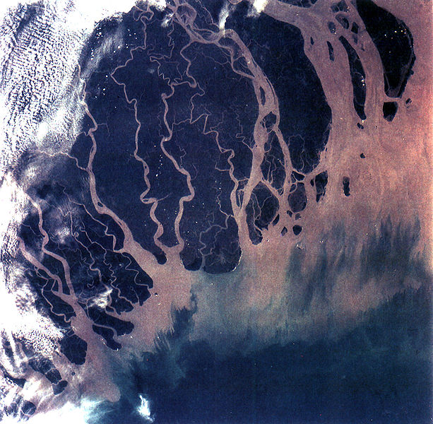
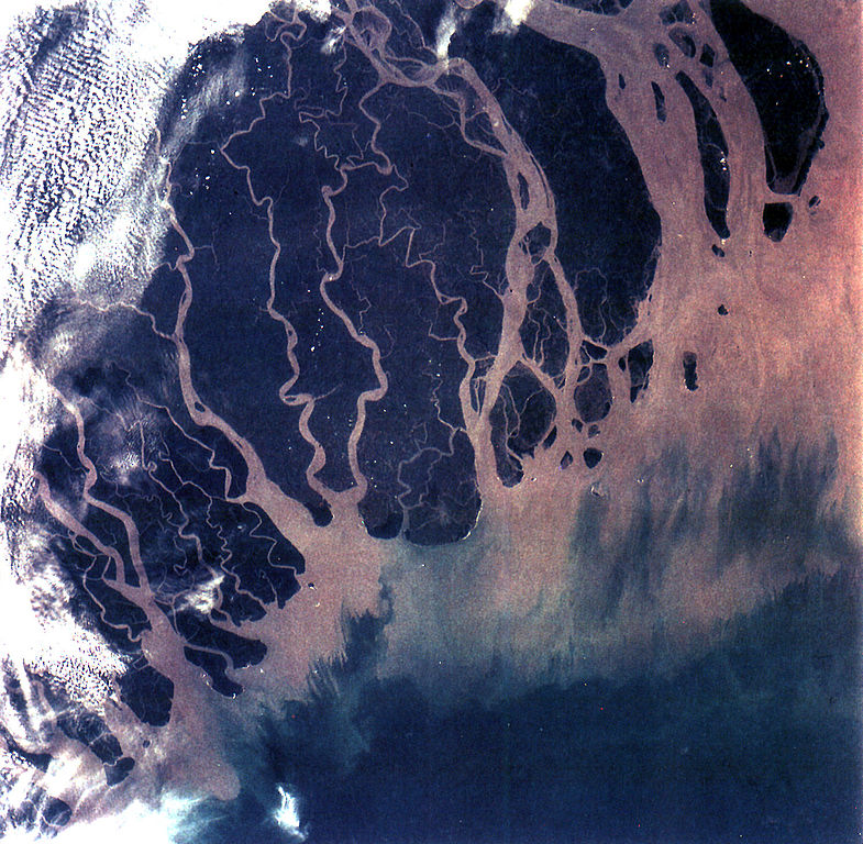
The Ganges River Delta (fig. 5) is the largest inter-tidal delta in the world. With its extensive mangrove mud flats, swamp vegetation and sand dunes, it is characteristic of many tropical and subtropical coasts. The vegetation cushions the shoreline from wind and wave action while the mangrove trees provide a habitat and food for aquatic and terrestrial plant and animal life. The increasing demand for lumber and firewood is outpacing the natural re-growth of the mangrove trees. Space Shuttle photographs, taken over time, permit monitoring of environmental changes in the delta caused by population pressures, and allows mapping of geological changes caused by shifting distributaries and delta growth. As seen in this photograph, the tributaries and distributaries of the Ganges and Brahmaputra Rivers deposit huge amounts of silt and clay that create a shifting maze of waterways and islands in the Bay of Bengal.
Українська: Супутниковий знімок мангрових лісів Сундарбану в дельті Гангу, 6 листопада 1994 року.
GANGES RIVER DELTA, BANGLADESH, INDIA (STS066-92-013). The Ganges River Delta (fig. 5) is the largest inter-tidal delta in the world. With its extensive mangrove mud flats, swamp vegetation and sand dunes, it is characteristic of many tropical and subtr
ไฟล, ganges, river, delta, bangladesh, india, ไฟล, ประว, ไฟล, หน, าท, ภาพน, การใช, ไฟล, วนกลาง, อม, ลเก, ยวก, บภาพขนาดของต, วอย, างน, กเซล, ความละเอ, ยดอ, กเซล, กเซล, กเซล, กเซล, กเซล, ภาพท, ความละเอ, ยดส, งกว, 8206, กเซล, ขนาดไฟล, โลไบต, ชน, ดไมม, image, jpeg. ifl prawtiifl hnathimiphaphni karichiflswnklang khxmulekiywkbphaphkhnadkhxngtwxyangni 613 600 phikesl khwamlaexiydxun 245 240 phikesl 491 480 phikesl 785 768 phikesl 1 046 1 024 phikesl 1 400 1 370 phikesl duphaphthimikhwamlaexiydsungkwa 8206 1 400 1 370 phikesl khnadifl 805 kiolibt chnidimm image jpeg rupphaphhruxiflesiyngni tnchbbxyuthi khxmmxns raylaexiyddanlang epnkhxkhwamthiaesdngphlcak ifltnchbbinkhxmmxns khxmmxnsepnewbistinokhrngkarsahrbekbrwbrwmsuxesri thi khunsamarthchwyid khaxthibayGanges River Delta Bangladesh India jpg The Ganges River Delta fig 5 is the largest inter tidal delta in the world With its extensive mangrove mud flats swamp vegetation and sand dunes it is characteristic of many tropical and subtropical coasts The vegetation cushions the shoreline from wind and wave action while the mangrove trees provide a habitat and food for aquatic and terrestrial plant and animal life The increasing demand for lumber and firewood is outpacing the natural re growth of the mangrove trees Space Shuttle photographs taken over time permit monitoring of environmental changes in the delta caused by population pressures and allows mapping of geological changes caused by shifting distributaries and delta growth As seen in this photograph the tributaries and distributaries of the Ganges and Brahmaputra Rivers deposit huge amounts of silt and clay that create a shifting maze of waterways and islands in the Bay of Bengal Ukrayinska Suputnikovij znimok mangrovih lisiv Sundarbanu v delti Gangu 6 listopada 1994 roku wnthi 6 phvscikayn ph s 2537aehlngthima http eol jsc nasa gov debrief STS066 rep2 htm http eol jsc nasa gov scripts sseop photo pl mission STS066 amp roll 100 amp frame 027phusrangsrrkh NASA Public domain Public domain false falsephaphniepnsatharnsmbti enuxngcakepnphaphthisrangkhunodyxngkhkarbriharkarbinaelaxwkasaehngchati NASA sungtamnoybaydanlikhsiththikhxngnasarabuiwwa phaphaelasuxtang khxngnasaimidrbkarkhumkhrxngodylikhsiththiykewncarabuiwwamilikhsiththi duephimthi hnanoybaydanlikhsiththikhxngnasa hrux noybaykarichphaphkhxng JPLkhaetuxn karich olokkhxngnasa ekhruxnghmayaelaekhruxngpradbkhxngnasa thukcakddwykdhmayshrthxemrikainlksna 14 khxngkhxbngkhbthangrachkarshrthxemrika swnthi 1221 ewbistkhxngnasaekbrwbrwmphaphthimacakxngkhkarxwkasosewiyt xngkhkarxwkasaehngchatirsesiy aelaxngkhkarxwkasthimiichxngkhkarxwkaskhxngshrthxemrika epncanwnmak phaphehlaniimcaepntxngepnsatharnsmbtiesmxip phaphhruxsuxthimacak klxngothrthrrsnxwkashbebil xacmilikhsiththi hakphaphhruxsuxnnimidrabuchdecnwamacak sthabnwithyasastrklxngothrthrrsnxwkas 1 phaphhruxsuxthnghmdthimacakekhruxngmuxkhxng okhrngkarsuksadwngxathityaelalmsuriya milikhsiththi karnaphaphhruxsuxcakokhrngkaripichnxkehnuxcakkarichephuxkarkhahruxephuxkarsuksa txngidrbxnuyatkxn 2 phaphthithukkhdeluxkihepn phaphdarasastrpracawn APOD bnewbistkhxng APOD xacmilikhsiththi 3 khabrryayodyyxithyephimkhabrryaythrrthdediywephuxkhyaykhwamwaiflnimixairxngkvsGanges and brahmabutra Delta India and Bangladesh ixethmthiaesdngxyuiniflniprakxbdwywnthisrang wnkxtng6 phvscikayn 1994 prawtiifl khlikwnthi ewlaephuxduiflthipraktinkhnann wnthi ewlarupyxkhnadphuichkhwamehn pccubn03 07 26 tulakhm 25481 400 1 370 805 kiolibt Brian0918GANGES RIVER DELTA BANGLADESH INDIA STS066 92 013 The Ganges River Delta fig 5 is the largest inter tidal delta in the world With its extensive mangrove mud flats swamp vegetation and sand dunes it is characteristic of many tropical and subtr hnathimiphaphni hnatxipni oyngmathiphaphni dindxnsamehliympakaemna samehliympakaemnakhngkha karichiflswnklang wikixuntxipniichiflni karichbn ar wikipedia org دلتا سياسة مائية مستخدم محمود محمد الشوبكى ملعب12 karichbn ast wikipedia org Delta fluvial karichbn bh wikipedia org नद ड ल ट karichbn bn wikipedia org গঙ গ র জল বণ টন ভ রত র ক ষ ব ল দ শ র ভ তত ত ব karichbn br wikipedia org Delta ster Brahmapoutra karichbn ca wikipedia org Delta fluvial karichbn cs wikipedia org Ganga Ricni delta Portal Geografie Obrazek tydne Archiv Portal Geografie Obrazek tydne 2009 51 karichbn cy wikipedia org Sundarbans karichbn da wikipedia org Sundarbans karichbn en wikipedia org Geography of Bangladesh River delta Geography of West Bengal Water politics Geology of Bangladesh Ganges water dispute Portal Geography Featured picture 2009 week 39 Portal Geography Featured picture archive 2009 Outline of geography User Bettymnz4 Geology of Bangladesh Flood pulse concept User talk Vsmith Archive27 Deltaic lobe karichbn eo wikipedia org Riverdelto karichbn es wikipedia org Delta fluvial Sundarbans Distributario karichbn et wikipedia org Kasutaja TJairus Delta karichbn eu wikipedia org Ibai delta karichbn ext wikipedia org Delta karichbn fr wikipedia org Delta hydrologie Geographie du Bangladesh Bassin Gange Brahmapoutre Meghna karichbn gl wikipedia org Bangladesh Delta fluvial Lista de cuncas hidrograficas por superficie karichbn hif wikipedia org Brahmaputra Naddi karichbn hi wikipedia org प रव शद व र पश च म ब ग ल प रव शद व र पश च म ब ग ल चयन त पर यटन स थल व क प ड य आज क आल ख प र ल ख २००९ ज न स च आज क आल ख २४ ज न २००९ प रव शद व र प र स थ त क प रव शद व र प र स थ त क चयन त ल ख dukarichthwolkephimetimkhxngiflnikhxmulekiywkbphaph phaphnimikhxmulephimetim sungswnihymacakklxngdicitxlhruxsaeknenxrthisamarthekbkhxmuldngklawiwrwmkbphaphid thaphaphnithukprbprungaekikhhruxepliynaeplngcakedim khxmulbangxyangcayngkhngimepliynaeplngehmuxnphaphthithukprbprungaekikhnnkarcdwangphaphpktikhwamlaexiydaenwnxn300 dpikhwamlaexiydaenwtng300 dpisxftaewrthiichAdobe Photoshop CS2 Windowsaekikhphaphlasud16 04 25 tulakhm 2548sepssiimidprbethiyb ekhathungcak https th wikipedia org wiki ifl Ganges River Delta Bangladesh India jpg, wikipedia, วิกิ หนังสือ, หนังสือ, ห้องสมุด,