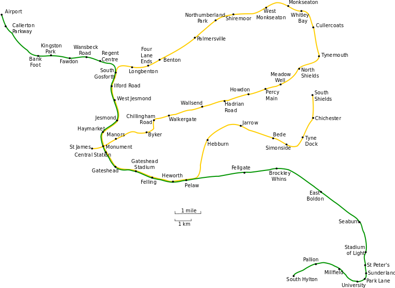
Geographically accurate map of the Tyne and Wear Metro system.
t
วันที่
(UTC)
แหล่งที่มา
Geographic_Tyne_and_Wear_Metro_map.gif
ผู้สร้างสรรค์
Geographic_Tyne_and_Wear_Metro_map.gif: Original uploader was Johnwalton at en.wikipedia
derivative work: Aveekbh (talk)
ภาพนี้ ได้รับการปรับแต่งภาพ ซึ่งหมายความว่าจะได้รับการเปลี่ยนแปลงภาพต่างจากต้นฉบับ การปรับปรุง: Converted to SVG; used larger text font.. ต้นฉบับสามารถดูได้ที่นี่: Geographic Tyne and Wear Metro map.gif. ปรับแต่งภาพโดย Aveekbh.
This image is a derivative work of the following images:
File:Geographic_Tyne_and_Wear_Metro_map.gif licensed with GFDL
2007-07-16T02:55:27Z Responsible? 1189x844 (30138 Bytes) {{Information |Description=Geographically accurate map of the Tyne and Wear Metro system. |Source=Originally from [http://en.wikipedia.org en.wikipedia]; description page is/was [http://en.wikipedia.org/w/index.php?title=Imag
{{Information |Description=Geographically accurate map of the Tyne and Wear Metro system. Inkscape-specific SVG, separated into layers for easy editing. |Source=*File:Geographic_Tyne_and_Wear_Metro_map.gif |Date=2009-04-01 17:26 (UTC) |Author=*[[:Fi
ไฟล, geographic, tyne, wear, metro, ไฟล, ประว, ไฟล, หน, าท, ภาพน, การใช, ไฟล, วนกลางขนาดของต, วอย, าง, ของไฟล, กเซล, ความละเอ, ยดอ, กเซล, กเซล, กเซล, กเซล, กเซล, กเซล, ภาพท, ความละเอ, ยดส, งกว, 8206, ไฟล, กเซล, ขนาดไฟล, โลไบต, ปภาพหร, อไฟล, เส, ยงน, นฉบ, บอย, . ifl prawtiifl hnathimiphaphni karichiflswnklangkhnadkhxngtwxyang PNG nikhxngifl SVG ni 800 583 phikesl khwamlaexiydxun 320 233 phikesl 640 466 phikesl 1 024 746 phikesl 1 280 932 phikesl 2 560 1 865 phikesl 1 149 837 phikesl duphaphthimikhwamlaexiydsungkwa 8206 ifl SVG 1 149 837 phikesl khnadifl 21 kiolibt rupphaphhruxiflesiyngni tnchbbxyuthi khxmmxns raylaexiyddanlang epnkhxkhwamthiaesdngphlcak ifltnchbbinkhxmmxns khxmmxnsepnewbistinokhrngkarsahrbekbrwbrwmsuxesri thi khunsamarthchwyid khaxthibayGeographic Tyne and Wear Metro map svg Geographically accurate map of the Tyne and Wear Metro system twnthi 1 emsayn ph s 2552 14 59 UTC aehlngthima Geographic Tyne and Wear Metro map gifphusrangsrrkh Geographic Tyne and Wear Metro map gif Original uploader was Johnwalton at en wikipedia derivative work Aveekbh talk phaphni idrbkarprbaetngphaph sunghmaykhwamwacaidrbkarepliynaeplngphaphtangcaktnchbb karprbprung Converted to SVG used larger text font tnchbbsamarthduidthini Geographic Tyne and Wear Metro map gif prbaetngphaphody Aveekbh khapheca inthanaphuthuxlikhsiththikhxngphaphhruxsuxni xnuyatihichphaphhruxsuxniphayitenguxnikhtxipni xnuyatihkhdlxk aeckcayaela hruxddaeprexksarniphayitenguxnikhkhxngsyyaxnuyatexksaresrikhxngknu run 1 2 hruxrunid nbcaknithixxkodymulnithisxftaewresri odyimmiswnidhamaekikh immikhxkhwampkhnaaelapkhlng saenakhxngsyyaxnuyatrwmxyuinswnchux syyaxnuyatexksaresrikhxngknuhttp www gnu org copyleft fdl html GFDL GNU Free Documentation License true trueiflnixyuphayitsyyaxnuyat khriexthifkhxmmxns aebbaesdngthima xnuyataebbediywkn 3 0 tnchbbkhunsamarth thicaaebngpn thicathasaena aeckcay aelasngngandngklawtxip thicaeriyberiyngihm thicaddaeplngngandngklaw phayitenguxnikhtxipni aesdngthima khuntxngihekiyrtiecakhxngnganxyangehmaasm odyephimlingkipyngsyyaxnuyat aelarabuhakmikarepliynaeplng khunxacthaechnniidinrupaebbidkidtamkhwr aettxngimichinlksnathiaenawaphuihxnuyatsnbsnunkhunhruxkarichngankhxngkhun xnuyataebbediywkn hakkhunddaeplng epliynrup hruxtxetimnganni khuntxngichsyyaxnuyataebbediywknhruxaebbthiehmuxnkbsyyaxnuyatthiichkbnganniethannpayaesdngsthanalikhsiththinithukephimephuxihepniptamkarepliynaeplngsyyaxnuyatkhxngmulnithiwikimiediy cak GFDL ipyng GFDL khwbkhukb CC BY SA 3 0 http creativecommons org licenses by sa 3 0 CC BY SA 3 0 Creative Commons Attribution Share Alike 3 0 true true bnthukkarxphohld This image is a derivative work of the following images File Geographic Tyne and Wear Metro map gif licensed with GFDL 2007 07 16T02 55 27Z Responsible 1189x844 30138 Bytes Information Description Geographically accurate map of the Tyne and Wear Metro system Source Originally from http en wikipedia org en wikipedia description page is was http en wikipedia org w index php title ImagUploaded with derivativeFXkhabrryayodyyxithyephimkhabrryaythrrthdediywephuxkhyaykhwamwaiflnimixairixethmthiaesdngxyuiniflniprakxbdwysthanalikhsiththimilikhsiththisyyaxnuyatGNU Free Documentation License version 1 2 or later xngkvsCreative Commons Attribution ShareAlike 3 0 Unported xngkvswnthisrang wnkxtng1 emsayn 2009 prawtiifl khlikwnthi ewlaephuxduiflthipraktinkhnann wnthi ewlarupyxkhnadphuichkhwamehn pccubn17 37 9 tulakhm 25531 149 837 21 kiolibt Johnwalton Simonside correct dot placement 05 24 18 thnwakhm 25521 149 837 54 kiolibt JohnwaltonReverted to version as of 16 27 1 April 2009 dots are rendering misplaced 04 59 18 thnwakhm 25521 149 837 44 kiolibt JohnwaltonAdded Simonside station Minor update to some text spacing and correct spelling of Whitley Bay 23 27 1 emsayn 25521 149 837 54 kiolibt Aveekbh Information Description Geographically accurate map of the Tyne and Wear Metro system Inkscape specific SVG separated into layers for easy editing Source File Geographic Tyne and Wear Metro map gif Date 2009 04 01 17 26 UTC Author Fi 21 01 1 emsayn 25521 149 837 49 kiolibt Aveekbh Information Description Geographically accurate map of the Tyne and Wear Metro system t Source File Geographic Tyne and Wear Metro map gif Date 2009 04 01 14 59 UTC Author File Geographic Tyne and Wear Metro map gif Original upload hnathimiphaphni hnatxipni oyngmathiphaphni rthifitdinithnaexndaewr karichiflswnklang wikixuntxipniichiflni karichbn af wikipedia org Topologie karichbn ca wikipedia org Metro de Tyne and Wear karichbn de wikipedia org Tyne and Wear Metro karichbn de wikivoyage org Newcastle upon Tyne karichbn en wikipedia org Talk Merseyrail Archive 2 Talk Tyne and Wear Metro Archive 1 karichbn es wikipedia org Anexo Sistemas de metro karichbn eu wikipedia org Tyne eta Wearko metroa karichbn fa wikipedia org متروی تاین و ور karichbn fi wikipedia org Newcastle upon Tyne karichbn hu wikipedia org Newcastle i metro karichbn hy wikipedia org Նյուքասլ ափոն Թայն karichbn it wikipedia org Metropolitana del Tyne and Wear karichbn ja wikipedia org タイン アンド ウィア メトロ karichbn ms wikipedia org Metro Tyne dan Wear karichbn pl wikipedia org Tyne and Wear Metro karichbn tr wikipedia org Tyne ve Wear metrosu karichbn www wikidata org Q541027 ekhathungcak https th wikipedia org wiki ifl Geographic Tyne and Wear Metro map svg, wikipedia, วิกิ หนังสือ, หนังสือ, ห้องสมุด,