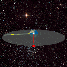
English: A geostationary orbit can only be achieved at an altitude very close to 35,786 km (22,236 mi), and directly above the equator. This equates to an orbital velocity of 3.07 km/s (1.91 mi/s) or a period of 1,436 minutes, which equates to almost exactly one sidereal day or 23.934461223 hours. This makes sense considering that the satellite must be locked to the Earth's rotational period in order to have a stationary footprint on the ground. In practice, this means that all geostationary satellites have to exist on this ring
ไฟล, geostationaryjava3dsideview, ไฟล, ประว, ไฟล, หน, าท, ภาพน, การใช, ไฟล, วนกลาง, อม, ลเก, ยวก, บภาพไม, ภาพท, รายละเอ, ยดส, งกว, าน, geostationaryjava3dsideview, 8206, กเซล, ขนาดไฟล, โลไบต, ชน, ดไมม, image, วนซ, เฟรม, นาท, ปภาพหร, อไฟล, เส, ยงน, นฉบ, บอย, คอ. ifl prawtiifl hnathimiphaphni karichiflswnklang khxmulekiywkbphaphimmiphaphthimiraylaexiydsungkwani Geostationaryjava3Dsideview gif 8206 220 220 phikesl khnadifl 111 kiolibt chnidimm image gif wnsa 163 efrm 12 winathi rupphaphhruxiflesiyngni tnchbbxyuthi khxmmxns raylaexiyddanlang epnkhxkhwamthiaesdngphlcak ifltnchbbinkhxmmxns khxmmxnsepnewbistinokhrngkarsahrbekbrwbrwmsuxesri thi khunsamarthchwyid khwamyx khaxthibayGeostationaryjava3Dsideview gif English A geostationary orbit can only be achieved at an altitude very close to 35 786 km 22 236 mi and directly above the equator This equates to an orbital velocity of 3 07 km s 1 91 mi s or a period of 1 436 minutes which equates to almost exactly one sidereal day or 23 934461223 hours This makes sense considering that the satellite must be locked to the Earth s rotational period in order to have a stationary footprint on the ground In practice this means that all geostationary satellites have to exist on this ringhttp weelookang blogspot com 2010 07 ejs open source geostationary satellite html wnthi 27 mithunayn ph s 2554 aehlngthima ngankhxngtw phusrangsrrkh Lookang many thanks to author of original simulation Francisco Esquembre author of Easy Java Simulation Francisco Esquembre karxnuyat karichiflniihm khapheca inthanaphuthuxlikhsiththikhxngphaphhruxsuxni xnuyatihichphaphhruxsuxniphayitenguxnikhtxipniiflnixyuphayitsyyaxnuyat khriexthifkhxmmxns aebbaesdngthima xnuyataebbediywkn 3 0 tnchbbkhunsamarth thicaaebngpn thicathasaena aeckcay aelasngngandngklawtxip thicaeriyberiyngihm thicaddaeplngngandngklaw phayitenguxnikhtxipni aesdngthima khuntxngihekiyrtiecakhxngnganxyangehmaasm odyephimlingkipyngsyyaxnuyat aelarabuhakmikarepliynaeplng khunxacthaechnniidinrupaebbidkidtamkhwr aettxngimichinlksnathiaenawaphuihxnuyatsnbsnunkhunhruxkarichngankhxngkhun xnuyataebbediywkn hakkhunddaeplng epliynrup hruxtxetimnganni khuntxngichsyyaxnuyataebbediywknhruxaebbthiehmuxnkbsyyaxnuyatthiichkbnganniethannhttps creativecommons org licenses by sa 3 0 CC BY SA 3 0 Creative Commons Attribution Share Alike 3 0 true truekhabrryayodyyxithyephimkhabrryaythrrthdediywephuxkhyaykhwamwaiflnimixairixethmthiaesdngxyuiniflniprakxbdwyphusrangbangkhathiimmiixethmwikisnethschuxphusrangsrrkh Lookangchuxphuichwikimiediy LookangsthanalikhsiththimilikhsiththisyyaxnuyatCreative Commons Attribution ShareAlike 3 0 Unported nbsp xngkvswnthisrang wnkxtng27 mithunayn 2011thimakhxngiflkarsrangdngedimodyphuxpohld prawtiifl khlikwnthi ewlaephuxduiflthipraktinkhnann wnthi ewlarupyxkhnadphuichkhwamehn pccubn12 04 12 mithunayn 2556220 220 111 kiolibt Lookangupdated earth texture with public domain better resolution 12 02 12 mithunayn 2556220 220 420 kiolibt Lookangupdated with public domain earth texture radius of earth is proportional to geostationary orbit now 08 29 27 mithunayn 2554220 220 420 kiolibt Lookang hnathimiphaphni hnatxipni oyngmathiphaphni dawethiymphxngkhabolk karichiflswnklang wikixuntxipniichiflni karichbn ar wikipedia org مدار جغرافي ثابت قمر اصطناعي متزامن مع الأرض قائمة كويكبات متجاوزة قريبة للأرض karichbn ast wikipedia org orbita xeoestacionaria karichbn bn wikipedia org ভ স থ র কক ষপথ karichbn ca wikipedia org Satel lit geoestacionari karichbn en wikipedia org Geosynchronous satellite List of asteroid close approaches to Earth karichbn eo wikipedia org Satelita televido karichbn es wikipedia org orbita geoestacionaria Velocidad orbital karichbn es wikiversity org Satelite Artificial karichbn et wikipedia org Satelliittelevisioon Satelliitraadio Geostatsionaarne orbiit karichbn fa wikipedia org مدار زمین ایستا ماهواره زمین همگام karichbn fr wikipedia org Wikipedia Projets pedagogiques Cegep de Chicoutimi NYA karichbn gl wikipedia org orbita xeoestacionaria karichbn he wikipedia org לוויין גאוסינכרוני karichbn hi wikipedia org भ स थ र कक ष karichbn hu wikipedia org Geostacionarius palya karichbn ml wikipedia org ഭ മക ന ദ ര ഭ രമണപഥ ഇൻസ റ റ 3ഡ karichbn ms wikipedia org Satelit geosinkron karichbn no wikipedia org Geostasjonaer satellitt karichbn pl wikipedia org Orbita geostacjonarna karichbn pt wikipedia org Satelite geoestacionario Velocidade orbital Dilatacao do tempo karichbn ru wikipedia org Uchastnik Eligatron Illyustracii dlya statej o kosmonavtike 5 karichbn simple wikipedia org Geostationary orbit karichbn ta wikipedia org ப வ ந ல ச ச ற ற ப ப த karichbn te wikipedia org భ స థ ర కక ష య భ సమవర తన ఉపగ రహ karichbn tg wikipedia org Madori zaministo karichbn uk wikipedia org Spisok nablizhen asteroyidiv do Zemli karichbn zh wikipedia org 地球同步卫星khxmulekiywkbphaph phaphnimikhxmulephimetim sungswnihymacakklxngdicitxlhruxsaeknenxrthisamarthekbkhxmuldngklawiwrwmkbphaphid thaphaphnithukprbprungaekikhhruxepliynaeplngcakedim khxmulbangxyangcayngkhngimepliynaeplngehmuxnphaphthithukprbprungaekikhnnkhwamehnifl GIFTitle geostationayJav3d2013side Author lookang ekhathungcak https th wikipedia org wiki ifl Geostationaryjava3Dsideview gif, wikipedia, วิกิ หนังสือ, หนังสือ, ห้องสมุด,