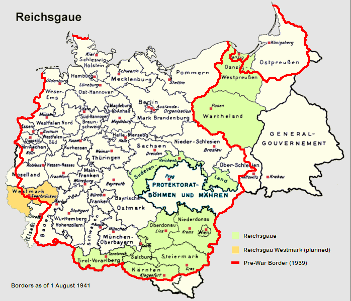
English: Reichsgaue and Generalgouvernement in June 1941
Deutsch: Reichsgaue und Generalgouvernement im Jahre 1941.
Français : La Pologne démembrée dans l'Europe allemande.
Polski: Aneksje III Rzeszy w czasie II wojny światowej (do sierpnia 1941), linia czerwona pokazuje przebieg granicy państwowej Rzeszy 1 września 1939 (wyodrębnione również Wolne Miasto Gdańsk). Aneksje terytorialne III Rzeszy do sierpnia 1941,linia czerwona - przebieg granicy państwowej Niemiec 1 września 1939. Wyodrębniony teren Generalnego Gubernatorstwa. III Rzesza oraz terytoria anektowane i Generalne Gubernatorstwo w sierpniu 1941, linia czerwona pokazuje przebieg granicy Niemiec 1 września 1939. Aneksje III Rzeszy w czasie II wojny światowej (do sierpnia 1941), linia czerwona pokazuje przebieg granicy państwowej Rzeszy 1 września 1939 (wyodrębnione również Wolne Miasto Gdańsk).
Italiano: Il Reichsgau e il Governatorato Generale nel 1941.
Nederlands: Reichsgaue en het Gouvernement-Generaal in 1941.
Español: Mapa de Alemania en 1941, sobre el este (derecha del mapa) el Gobierno General.
中文(简体):1941年的纳粹德国,包括帝国大区与被吞并的波兰总督府。
中文(繁體):1941年的納粹德國,包括帝國大區與被吞併的波蘭總督府。
Norsk bokmål: Kart over Reichsgau i 1941.
Čeština: Generální gouvernement na mapě Třetí říše.
Tiếng Việt: Nước Đức năm 1941, bao gồm lãnh thổ của Ba Lan bị chiếm đóng.
Map of Germany in 1941 - Mapa de Alemania en 1941 GFDL from from [http://en.wikipedia.org/wiki/Image:Germany1941.png] Licencia GFDL, tomado de [http://en.wikipedia.org/wiki/Image:Germany1941.png].
ไฟล, germany1941, ไฟล, ประว, ไฟล, หน, าท, ภาพน, การใช, ไฟล, วนกลาง, อม, ลเก, ยวก, บภาพไม, ภาพท, รายละเอ, ยดส, งกว, าน, germany1941, 8206, กเซล, ขนาดไฟล, โลไบต, ชน, ดไมม, image, ปภาพหร, อไฟล, เส, ยงน, นฉบ, บอย, คอมมอนส, รายละเอ, ยดด, านล, าง, เป, นข, อความท, แส. ifl prawtiifl hnathimiphaphni karichiflswnklang khxmulekiywkbphaphimmiphaphthimiraylaexiydsungkwani Germany1941 png 8206 698 600 phikesl khnadifl 240 kiolibt chnidimm image png rupphaphhruxiflesiyngni tnchbbxyuthi khxmmxns raylaexiyddanlang epnkhxkhwamthiaesdngphlcak ifltnchbbinkhxmmxns khxmmxnsepnewbistinokhrngkarsahrbekbrwbrwmsuxesri thi khunsamarthchwyid khwamyx khaxthibayGermany1941 png English Reichsgaue and Generalgouvernement in June 1941 Deutsch Reichsgaue und Generalgouvernement im Jahre 1941 Francais La Pologne demembree dans l Europe allemande Polski Aneksje III Rzeszy w czasie II wojny swiatowej do sierpnia 1941 linia czerwona pokazuje przebieg granicy panstwowej Rzeszy 1 wrzesnia 1939 wyodrebnione rowniez Wolne Miasto Gdansk Aneksje terytorialne III Rzeszy do sierpnia 1941 linia czerwona przebieg granicy panstwowej Niemiec 1 wrzesnia 1939 Wyodrebniony teren Generalnego Gubernatorstwa III Rzesza oraz terytoria anektowane i Generalne Gubernatorstwo w sierpniu 1941 linia czerwona pokazuje przebieg granicy Niemiec 1 wrzesnia 1939 Aneksje III Rzeszy w czasie II wojny swiatowej do sierpnia 1941 linia czerwona pokazuje przebieg granicy panstwowej Rzeszy 1 wrzesnia 1939 wyodrebnione rowniez Wolne Miasto Gdansk Italiano Il Reichsgau e il Governatorato Generale nel 1941 Nederlands Reichsgaue en het Gouvernement Generaal in 1941 Espanol Mapa de Alemania en 1941 sobre el este derecha del mapa el Gobierno General 中文 简体 1941年的纳粹德国 包括帝国大区与被吞并的波兰总督府 中文 繁體 1941年的納粹德國 包括帝國大區與被吞併的波蘭總督府 Norsk bokmal Kart over Reichsgau i 1941 Cestina Generalni gouvernement na mape Treti rise Tiếng Việt Nước Đức năm 1941 bao gồm lanh thổ của Ba Lan bị chiếm đong aehlngthima based on de Bild Reichsgaue png modified and uploded as en Image Germany1941 pngphusrangsrrkh Morty Mackler Lucius1976ewxrchnxun de Bild Reichsgaue png karxnuyatichsiththi xnuyatihkhdlxk aeckcayaela hruxddaeprexksarniphayitenguxnikhkhxngsyyaxnuyatexksaresrikhxngknu run 1 2 hruxrunid nbcaknithixxkodymulnithisxftaewresri odyimmiswnidhamaekikh immikhxkhwampkhnaaelapkhlng saenakhxngsyyaxnuyatrwmxyuinswnchux syyaxnuyatexksaresrikhxngknuhttp www gnu org copyleft fdl html GFDL GNU Free Documentation License true trueiflnixyuphayitsyyaxnuyat khriexthifkhxmmxns aebbaesdngthima xnuyataebbediywkn 3 0 tnchbbkhunsamarth thicaaebngpn thicathasaena aeckcay aelasngngandngklawtxip thicaeriyberiyngihm thicaddaeplngngandngklaw phayitenguxnikhtxipni aesdngthima khuntxngihekiyrtiecakhxngnganxyangehmaasm odyephimlingkipyngsyyaxnuyat aelarabuhakmikarepliynaeplng khunxacthaechnniidinrupaebbidkidtamkhwr aettxngimichinlksnathiaenawaphuihxnuyatsnbsnunkhunhruxkarichngankhxngkhun xnuyataebbediywkn hakkhunddaeplng epliynrup hruxtxetimnganni khuntxngichsyyaxnuyataebbediywknhruxaebbthiehmuxnkbsyyaxnuyatthiichkbnganniethannpayaesdngsthanalikhsiththinithukephimephuxihepniptamkarepliynaeplngsyyaxnuyatkhxngmulnithiwikimiediy cak GFDL ipyng GFDL khwbkhukb CC BY SA 3 0 http creativecommons org licenses by sa 3 0 CC BY SA 3 0 Creative Commons Attribution Share Alike 3 0 true truekhabrryayodyyxithyephimkhabrryaythrrthdediywephuxkhyaykhwamwaiflnimixairixethmthiaesdngxyuiniflniprakxbdwysthanalikhsiththimilikhsiththisyyaxnuyatGNU Free Documentation License version 1 2 or later xngkvsCreative Commons Attribution ShareAlike 3 0 Unported xngkvsMIME type xngkvsimage png prawtiifl khlikwnthi ewlaephuxduiflthipraktinkhnann wnthi ewlarupyxkhnadphuichkhwamehn pccubn03 32 10 mithunayn 2560698 600 240 kiolibt HohumClearer colouring 21 08 25 kumphaphnth 2554698 600 279 kiolibt Morgan Hauser Bohemia Moravia was already integrated into the Third Reich before the outbreak of the war General fixes 22 52 6 knyayn 2549698 600 274 kiolibt ErnalveMap of Germany in 1941 Mapa de Alemania en 1941 GFDL from from http en wikipedia org wiki Image Germany1941 png Licencia GFDL tomado de http en wikipedia org wiki Image Germany1941 png hnathimiphaphni hnatxipni oyngmathiphaphni irchseka karichiflswnklang wikixuntxipniichiflni karichbn an wikipedia org Reichsgau karichbn ar wikipedia org الأراضي الشرقية السابقة لألمانيا رايخسجاو karichbn ca wikipedia org Reichsgau karichbn cs wikipedia org Generalni gouvernement karichbn de wikipedia org Fritz Arlt Deutsche Besetzung Polens 1939 1945 karichbn en wikipedia org Former eastern territories of Germany Reichsgau Talk Erika Steinbach Archive 3 Talk Reichsburger movement User Falcaorib karichbn es wikipedia org Historia territorial de Alemania Antiguos territorios orientales de Alemania karichbn fa wikipedia org هولوکاست karichbn fr wikipedia org Anciens territoires de l Est de l Allemagne karichbn hy wikipedia org Հոլոքոստ karichbn id wikipedia org Holokaus karichbn it wikipedia org Reichsgau Wartheland Aree polacche annesse alla Germania nazista Reichsgau Ex territori orientali della Germania karichbn ja wikipedia org アンシュルス 帝国大管区 旧ドイツ東部領土 karichbn lt wikipedia org Lenkijos okupacija 1939 1945 Generalgubernija karichbn nl wikipedia org Overleg Auschwitz concentratiekamp Generaal gouvernement Rijksgouw Rijksgouw Westmark Gouw NSDAP karichbn no wikipedia org Danzig Westpreussen karichbn pt wikipedia org Divisao administrativa dos territorios poloneses durante a Segunda Guerra Mundial Evolucao territorial da Alemanha Reichsgau karichbn sh wikipedia org Okupacija Jugoslavije u Drugom svetskom ratu karichbn sr wikipedia org Okupatorska podela Јugoslaviјe u Drugom svetskom ratu karichbn tr wikipedia org Holokost karichbn uk wikipedia org Okupaciya Yugoslaviyi karichbn vi wikipedia org Holocaust karichbn zh wikipedia org 納粹大屠殺 帝國大區khxmulekiywkbphaph phaphnimikhxmulephimetim sungswnihymacakklxngdicitxlhruxsaeknenxrthisamarthekbkhxmuldngklawiwrwmkbphaphid thaphaphnithukprbprungaekikhhruxepliynaeplngcakedim khxmulbangxyangcayngkhngimepliynaeplngehmuxnphaphthithukprbprungaekikhnnkhwamlaexiydaenwnxn37 79 dpckhwamlaexiydaenwtng37 79 dpcaekikhphaphlasud20 31 9 mithunayn 2560 ekhathungcak https th wikipedia org wiki ifl Germany1941 png, wikipedia, วิกิ หนังสือ, หนังสือ, ห้องสมุด,