The original description page was here. All following user names refer to en.wikipedia.
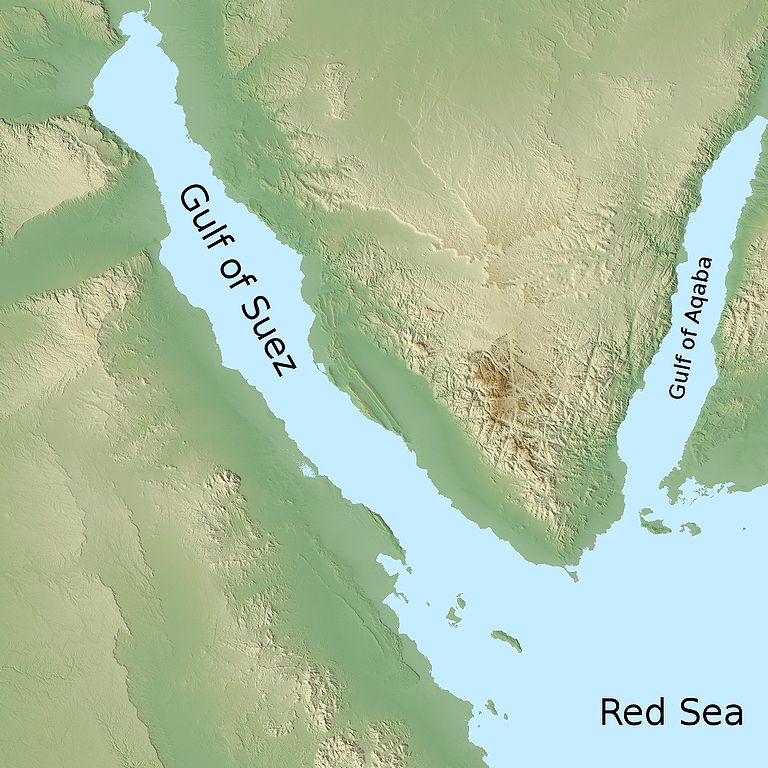
2009-02-10 09:31 Odie5533 1280×1280× (355904 bytes) {{Information |Description=A map depicting the location of the [[Gulf of Suez]] relative to the [[Red Sea]] |Source=I created this work entirely by myself. Using data from NASA which is not copyrighted unless noted. |Date=2009-02-10 |Author=~~~ |other_ver
{{Information |Description={{en|A map depicting the location of the en:Gulf of Suez relative to the en:Red Sea}} |Source=Transferred from [http://en.wikipedia.org en.wikipedia]<br/> (Original text : ''I created this work entirely by myself. Us
ไฟล, gulf, suez, ไฟล, ประว, ไฟล, หน, าท, ภาพน, การใช, ไฟล, วนกลาง, อม, ลเก, ยวก, บภาพขนาดของต, วอย, างน, กเซล, ความละเอ, ยดอ, กเซล, กเซล, กเซล, กเซล, กเซล, ภาพท, ความละเอ, ยดส, งกว, 8206, กเซล, ขนาดไฟล, โลไบต, ชน, ดไมม, image, jpeg, ปภาพหร, อไฟล, เส, ยงน, นฉบ,. ifl prawtiifl hnathimiphaphni karichiflswnklang khxmulekiywkbphaphkhnadkhxngtwxyangni 600 600 phikesl khwamlaexiydxun 240 240 phikesl 480 480 phikesl 768 768 phikesl 1 024 1 024 phikesl 1 280 1 280 phikesl duphaphthimikhwamlaexiydsungkwa 8206 1 280 1 280 phikesl khnadifl 348 kiolibt chnidimm image jpeg rupphaphhruxiflesiyngni tnchbbxyuthi khxmmxns raylaexiyddanlang epnkhxkhwamthiaesdngphlcak ifltnchbbinkhxmmxns khxmmxnsepnewbistinokhrngkarsahrbekbrwbrwmsuxesri thi khunsamarthchwyid khaxthibayGulf of Suez map jpg English A map depicting the location of the Gulf of Suez relative to the Red Sea wnthi 10 kumphaphnth ph s 2552 10 kumphaphnth ph s 2552 original upload date aehlngthima Transferred from en wikipedia Original text nbsp I created this work entirely by myself Using data from NASA which is not copyrighted unless noted phusrangsrrkh Odie5533 talk Original uploader was Odie5533 at en wikipedia karxnuyat karichiflniihm Released under the GNU Free Documentation License ewxrchnxun iflxunthiichiflni nbsp Gulf of Suez map DE png karxnuyatichsiththi Odie5533 at en wikipedia inthanaphuthuxlikhsiththikhxngphaphhruxsuxni xnuyatihichphaphhruxsuxniphayitenguxnikhtxipni xnuyatihkhdlxk aeckcayaela hruxddaeprexksarniphayitenguxnikhkhxngsyyaxnuyatexksaresrikhxngknu run 1 2 hruxrunid nbcaknithixxkodymulnithisxftaewresri odyimmiswnidhamaekikh immikhxkhwampkhnaaelapkhlng saenakhxngsyyaxnuyatrwmxyuinswnchux syyaxnuyatexksaresrikhxngknuhttp www gnu org copyleft fdl html GFDL GNU Free Documentation License true true iflnixyuphayitsyyaxnuyat khriexthifkhxmmxns aebbaesdngthima xnuyataebbediywkn 3 0 tnchbb karaesdngthima Odie5533 at en wikipedia khunsamarth thicaaebngpn thicathasaena aeckcay aelasngngandngklawtxip thicaeriyberiyngihm thicaddaeplngngandngklaw phayitenguxnikhtxipni aesdngthima khuntxngihekiyrtiecakhxngnganxyangehmaasm odyephimlingkipyngsyyaxnuyat aelarabuhakmikarepliynaeplng khunxacthaechnniidinrupaebbidkidtamkhwr aettxngimichinlksnathiaenawaphuihxnuyatsnbsnunkhunhruxkarichngankhxngkhun xnuyataebbediywkn hakkhunddaeplng epliynrup hruxtxetimnganni khuntxngichsyyaxnuyataebbediywknhruxaebbthiehmuxnkbsyyaxnuyatthiichkbnganniethann payaesdngsthanalikhsiththinithukephimephuxihepniptamkarepliynaeplngsyyaxnuyatkhxngmulnithiwikimiediy cak GFDL ipyng GFDL khwbkhukb CC BY SA 3 0 http creativecommons org licenses by sa 3 0 CC BY SA 3 0 Creative Commons Attribution Share Alike 3 0 true true bnthukkarxphohld The original description page was here All following user names refer to en wikipedia 2009 02 10 09 31 Odie5533 1280 1280 355904 bytes Information Description A map depicting the location of the Gulf of Suez relative to the Red Sea Source I created this work entirely by myself Using data from NASA which is not copyrighted unless noted Date 2009 02 10 Author other verkhabrryayodyyxithyephimkhabrryaythrrthdediywephuxkhyaykhwamwaiflnimixairixethmthiaesdngxyuiniflniprakxbdwysthanalikhsiththimilikhsiththisyyaxnuyatCreative Commons Attribution ShareAlike 3 0 Unported nbsp xngkvsGNU Free Documentation License version 1 2 or later nbsp xngkvswnthisrang wnkxtng10 kumphaphnth 2009 prawtiifl khlikwnthi ewlaephuxduiflthipraktinkhnann wnthi ewlarupyxkhnadphuichkhwamehn pccubn03 44 31 phvsphakhm 25521 280 1 280 348 kiolibt Urdangaray Information Description en A map depicting the location of the en Gulf of Suez relative to the en Red Sea Source Transferred from http en wikipedia org en wikipedia lt br gt Original text 039 039 I created this work entirely by myself Us hnathimiphaphni hnatxipni oyngmathiphaphni xawxlxaekaabah karichiflswnklang wikixuntxipniichiflni karichbn af wikipedia org Golf van Akaba Golf van Suez karichbn ar wikipedia org خليج العقبة ويكيبيديا ورشة الصور أرشيف 32 karichbn ast wikipedia org Golfu d Aqaba karichbn azb wikipedia org عقبه کؤرفزی سوئز کؤرفزی karichbn az wiktionary org Aqaba korfezi karichbn bg wikipedia org Suecki zaliv Akaba zaliv karichbn bn wikipedia org স য জ উপস গর আক ব উপস গর karichbn bs wikipedia org Akapski zaliv Sueski zaliv karichbn ca wikipedia org Golf d Aqaba karichbn ckb wikipedia org کەنداوی سوێس karichbn da wikipedia org Suezbugten karichbn el wikipedia org Kolpos toy Soyez karichbn en wikipedia org Gulf of Suez Gulf of Aqaba User Odie5533 Gallery karichbn es wikipedia org Golfo de Aqaba Golfo de Suez karichbn eu wikipedia org Aqabako golkoa karichbn fa wikipedia org خلیج سوئز karichbn fi wikipedia org Akabanlahti Suezinlahti karichbn fr wikipedia org Golfe d Aqaba Golfe de Suez karichbn fy wikipedia org Golf fan Suez karichbn gl wikipedia org Golfo de Aqaba Golfo de Suez karichbn gv wikipedia org Lhoob Aqaba karichbn hi wikipedia org अक ब क ख ड स एज क ख ड karichbn hu wikipedia org Sinai hegy karichbn hy wikipedia org Ակաբայի ծովածոց karichbn id wikipedia org Teluk Aqabah Penyeberangan Laut Merah Teluk Suez Pi Hahirot Etam karichbn ilo wikipedia org Golpo ti Suez Golpo ti Aqaba karichbn it wikipedia org Golfo di Aqaba karichbn ka wikipedia org აკაბის ყურე სუეცის ყურე karichbn kcg wikipedia org A ngam A sa khwot A ka ba karichbn ku wikipedia org Kendava Eqebeye karichbn lt wikipedia org Sueco įlanka dukarichthwolkephimetimkhxngiflnikhxmulekiywkbphaph phaphnimikhxmulephimetim sungswnihymacakklxngdicitxlhruxsaeknenxrthisamarthekbkhxmuldngklawiwrwmkbphaphid thaphaphnithukprbprungaekikhhruxepliynaeplngcakedim khxmulbangxyangcayngkhngimepliynaeplngehmuxnphaphthithukprbprungaekikhnn error0 ekhathungcak https th wikipedia org wiki ifl Gulf of Suez map jpg, wikipedia, วิกิ หนังสือ, หนังสือ, ห้องสมุด,