Chinese language version of "Map of Han foreign relations in CE 2"
Introduction
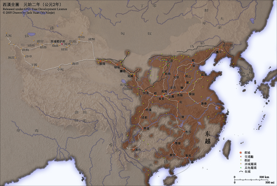
This map shows the world as was known to Han Dynasty China in CE 2. Names of non-Chinese peoples and states have been purposely left with their Chinese names (e.g. Dayuan instead of Fergana; Gaogouli instead of Goguryeo) to reflect the fact that our knowledge of participants in the Han world order comes almost exclusively from Chinese sources.
Credits
Chinese Version of Image:Han foreign relations CE 2.jpg.
Created and copyright (2005) by Yu Ninjie.
Released under the GNU FDL.
Territorial garrisons
The headquarters of chief commandants (都尉) are shown in yellow. Chief commandants commanded territorial garrisons and were responsible for the supression of local armed threats and supervision of recruitment for military service. Note that these were concentrated on the frontiers, especially on the northern border region. When in the interior of the Han empire, they were often placed near iron or salt industries, or on important communication routes. A few dependent states (屬國) are shown in green. These were usually mixed settlements of Chinese and Xiongnu or more commonly, Qiang, under Han administration.
The Great Wall
During most of the Western Han period, the Great Wall served as a line of demarcation between Han and non-Chinese peoples, most notable of whom were the Xiongnu. The line of the Great Wall was extended by Emperor Wu along the Gansu corridor (the commanderies based at Dunhuang, Lufu, Lude and Guzang). This, along with walls north of the great loop of the Yellow River (beyond Wuyuan), provided the front line defences against the Xiongnu. A second line was maintained along the old Qin wall (the one that passes close to Fushi and Didao), which was important even into the 1st century CE.
Both the lines of the Great Wall and Yellow River are based on Tan Qixiang (ed.), Zhongguo lishi ditu (中国历史地图集), 1982. Note that the Yellow River is considerably to the north of its present flow.
Routes of communication
The broad outline of communication and transport routes from the capital Chang'an is marked in white. These were based on Qin Dynasty imperial highways, Han roads (such as the Chang'an-Anyi-Taiyuan-Yu road) and navigable riverways (such as the Chenliu and Shouchun river routes). The long road, often known as the Silk Road, extended west from Chang'an to the "Western Regions".
These are based in part on the reconstruction of early Chinese roads and waterways by Joseph Needham in Science and Civilisation, Vol. IV, 1954-, and the additions of Rafe de Crespigny in Generals of the South, 1992. The northern and southern routes of the Silk Road in the Western Regions is based on Map 16 in Cambridge History of China, vol. 1, 1986.
The Western Regions
From the end of the 2nd century CE, Han China fought with the Xiongnu over control of the "Western Regions". By the time that they established the office of Protector General of the Western Regions (at Wulei) in 60 BCE or 59 BCE, the entire region was dominated by the Chinese. Tributary city-states, in light orange, sent periodic tribute to Chang'an and were rewarded by the Han court.
ไฟล, foreign, relations, chinese, ไฟล, ประว, ไฟล, หน, าท, ภาพน, การใช, ไฟล, วนกลาง, อม, ลเก, ยวก, บภาพขนาดของต, วอย, างน, กเซล, ความละเอ, ยดอ, กเซล, กเซล, กเซล, ภาพท, ความละเอ, ยดส, งกว, 8206, กเซล, ขนาดไฟล, โลไบต, ชน, ดไมม, image, jpeg, ปภาพหร, อไฟล, เส, ยงน,. ifl prawtiifl hnathimiphaphni karichiflswnklang khxmulekiywkbphaphkhnadkhxngtwxyangni 800 539 phikesl khwamlaexiydxun 320 216 phikesl 640 431 phikesl 965 650 phikesl duphaphthimikhwamlaexiydsungkwa 8206 965 650 phikesl khnadifl 530 kiolibt chnidimm image jpeg rupphaphhruxiflesiyngni tnchbbxyuthi khxmmxns raylaexiyddanlang epnkhxkhwamthiaesdngphlcak ifltnchbbinkhxmmxns khxmmxnsepnewbistinokhrngkarsahrbekbrwbrwmsuxesri thi khunsamarthchwyid Chinese language version of Map of Han foreign relations in CE 2 enuxha 1 Introduction 1 1 Territorial garrisons 1 2 The Great Wall 1 3 Routes of communication 1 4 The Western Regions 2 License and Source Introduction This map shows the world as was known to Han Dynasty China in CE 2 Names of non Chinese peoples and states have been purposely left with their Chinese names e g Dayuan instead of Fergana Gaogouli instead of Goguryeo to reflect the fact that our knowledge of participants in the Han world order comes almost exclusively from Chinese sources CreditsChinese Version of Image Han foreign relations CE 2 jpg Created and copyright 2005 by Yu Ninjie Released under the GNU FDL Territorial garrisons The headquarters of chief commandants 都尉 are shown in yellow Chief commandants commanded territorial garrisons and were responsible for the supression of local armed threats and supervision of recruitment for military service Note that these were concentrated on the frontiers especially on the northern border region When in the interior of the Han empire they were often placed near iron or salt industries or on important communication routes A few dependent states 屬國 are shown in green These were usually mixed settlements of Chinese and Xiongnu or more commonly Qiang under Han administration The Great Wall During most of the Western Han period the Great Wall served as a line of demarcation between Han and non Chinese peoples most notable of whom were the Xiongnu The line of the Great Wall was extended by Emperor Wu along the Gansu corridor the commanderies based at Dunhuang Lufu Lude and Guzang This along with walls north of the great loop of the Yellow River beyond Wuyuan provided the front line defences against the Xiongnu A second line was maintained along the old Qin wall the one that passes close to Fushi and Didao which was important even into the 1st century CE Both the lines of the Great Wall and Yellow River are based on Tan Qixiang ed Zhongguo lishi ditu 中国历史地图集 1982 Note that the Yellow River is considerably to the north of its present flow Routes of communication The broad outline of communication and transport routes from the capital Chang an is marked in white These were based on Qin Dynasty imperial highways Han roads such as the Chang an Anyi Taiyuan Yu road and navigable riverways such as the Chenliu and Shouchun river routes The long road often known as the Silk Road extended west from Chang an to the Western Regions These are based in part on the reconstruction of early Chinese roads and waterways by Joseph Needham in Science and Civilisation Vol IV 1954 and the additions of Rafe de Crespigny in Generals of the South 1992 The northern and southern routes of the Silk Road in the Western Regions is based on Map 16 in Cambridge History of China vol 1 1986 The Western Regions From the end of the 2nd century CE Han China fought with the Xiongnu over control of the Western Regions By the time that they established the office of Protector General of the Western Regions at Wulei in 60 BCE or 59 BCE the entire region was dominated by the Chinese Tributary city states in light orange sent periodic tribute to Chang an and were rewarded by the Han court License and Source xnuyatihkhdlxk aeckcayaela hruxddaeprexksarniphayitenguxnikhkhxngsyyaxnuyatexksaresrikhxngknu run 1 2 hruxrunid nbcaknithixxkodymulnithisxftaewresri odyimmiswnidhamaekikh immikhxkhwampkhnaaelapkhlng saenakhxngsyyaxnuyatrwmxyuinswnchux syyaxnuyatexksaresrikhxngknuhttp www gnu org copyleft fdl html GFDL GNU Free Documentation License true trueiflnixyuphayitsyyaxnuyat khriexthifkhxmmxns aebbaesdngthima xnuyataebbediywkn 3 0 tnchbbkhunsamarth thicaaebngpn thicathasaena aeckcay aelasngngandngklawtxip thicaeriyberiyngihm thicaddaeplngngandngklaw phayitenguxnikhtxipni aesdngthima khuntxngihekiyrtiecakhxngnganxyangehmaasm odyephimlingkipyngsyyaxnuyat aelarabuhakmikarepliynaeplng khunxacthaechnniidinrupaebbidkidtamkhwr aettxngimichinlksnathiaenawaphuihxnuyatsnbsnunkhunhruxkarichngankhxngkhun xnuyataebbediywkn hakkhunddaeplng epliynrup hruxtxetimnganni khuntxngichsyyaxnuyataebbediywknhruxaebbthiehmuxnkbsyyaxnuyatthiichkbnganniethannpayaesdngsthanalikhsiththinithukephimephuxihepniptamkarepliynaeplngsyyaxnuyatkhxngmulnithiwikimiediy cak GFDL ipyng GFDL khwbkhukb CC BY SA 3 0 http creativecommons org licenses by sa 3 0 CC BY SA 3 0 Creative Commons Attribution Share Alike 3 0 true trueSource Chinese Wikipedia original upload 2005年4月7日 木 by Yu NinjiekhabrryayodyyxithyephimkhabrryaythrrthdediywephuxkhyaykhwamwaiflnimixairixethmthiaesdngxyuiniflniprakxbdwysthanalikhsiththimilikhsiththisyyaxnuyatCreative Commons Attribution ShareAlike 3 0 Unported xngkvsGNU Free Documentation License version 1 2 or later xngkvs prawtiifl khlikwnthi ewlaephuxduiflthipraktinkhnann wnthi ewlarupyxkhnadphuichkhwamehn pccubn10 37 25 mithunayn 2552965 650 530 kiolibt KEIMSadd a name 16 29 13 thnwakhm 2548965 650 516 kiolibt Shizhao 09 51 4 tulakhm 2548965 650 558 kiolibt Saperaud commonswikiChinese Version of Image Han foreign relations CE 2 jpg Created and copyright 2005 by Yu Ninjie Released under the GNU FDL This map shows the world as was known to Han Dynasty China hnathimiphaphni hnatxipni oyngmathiphaphni rachwngshntawntk rayphranamckrphrrdiaelaphramhakstriycin karichiflswnklang wikixuntxipniichiflni karichbn av wikipedia org 2 son karichbn azb wikipedia org هان سولا له سی karichbn fi wikipedia org Kayttaja Fiwiki tools bot kuvattomat 9 karichbn incubator wikimedia org Wp cpx Mang e h karichbn ja wikipedia org 閩越 漢の南方拡大 karichbn rue wikipedia org 2 rik karichbn ru wikipedia org 2 god karichbn wikimania2006 wikimedia org Wikimania Awards Maps and Diagrams Premios Judge Ben Yates Wikimania Awards Finalists karichbn yi wikipedia org 2 karichbn zh classical wikipedia org 維基大典 卓著 漢 User Ericmetro 沙盒 模板 週一絕妙好文 存檔 漢 karichbn zh min nan wikipedia org Se Han Ban oa t karichbn zh wikipedia org 閩越 Portal 中国 特色图片 1 Portal 中国 特色图片 存档 Wikipedia 特色圖片評選 除名 西漢地圖 Wikipedia 特色圖片評選 存檔 2008年8月 Wikipedia 已撤销的特色图片 Wikipedia 特色圖片評選 特色圖片除名存檔 存檔1khxmulekiywkbphaph phaphnimikhxmulephimetim sungswnihymacakklxngdicitxlhruxsaeknenxrthisamarthekbkhxmuldngklawiwrwmkbphaphid thaphaphnithukprbprungaekikhhruxepliynaeplngcakedim khxmulbangxyangcayngkhngimepliynaeplngehmuxnphaphthithukprbprungaekikhnnkarcdwangphaphpktikhwamlaexiydaenwnxn150 dpikhwamlaexiydaenwtng150 dpisxftaewrthiichAdobe Photoshop CS2 Windowsaekikhphaphlasud23 36 24 mithunayn 2552sepssisRGBkhwamkwangkhxngphaph965 phikeslkhwamsungkhxngphaph650 phikeslewlathiaeplngepndicithl22 58 7 emsayn 2548wnthiaekikhkhxmulemtalasud19 36 24 mithunayn 2552run IIM2 ekhathungcak https th wikipedia org wiki ifl Han foreign relations CE 2 chinese jpg, wikipedia, วิกิ หนังสือ, หนังสือ, ห้องสมุด,