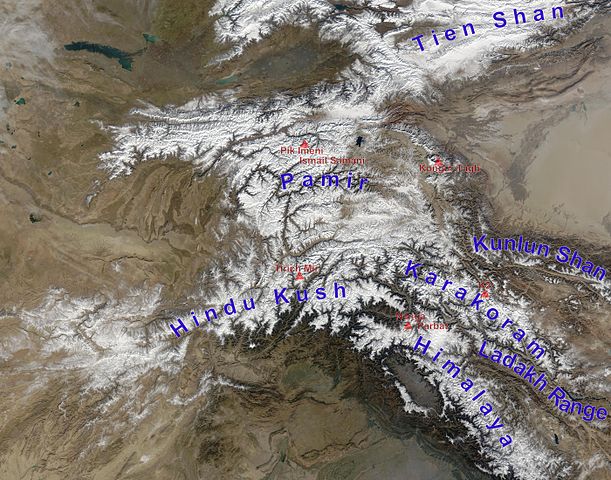
English: high Asian mountain ranges and their highest mountains:
Tien Shan – Jengish Chokusu is outside the picture,
Kunlun Shan – Kongur Tagh. Note: Some sources count Kongur to the Pamirs. Liushi Shan, the highest mountain of Kunlun Shan not counting Kongur is outside the picture
Pamir – Kongur Tagh (if not counted to Kunlun Shan), Pik Imeni Ismail Samani (if Kongur belongs to Kunlun Shan)
Hindu Kush – Tirich Mir >> HERE MISTAKE IN THE MAP: The last 2½ letters of "Hindu Kush" are in the Hindu Raj mountain range which spread out eastwards to the huge S-shaped Indus valley (crossing the first letter of "Nanga Parbat")
Karakoram – K2
Himalayas – Nanga Parbat is the highest mountain of the western Himalayas, there are of course seven higher Eightthousanders in the eastern Himalayas
Ladakh Range – no prominent high peak labelled
derivative work from File:Hindu Kush satellite image.jpg
Deutsch: Die innerasiatischen Hochgebirge:
Tien Shan – Der Dschengisch Tschokusu liegt außerhalb des Bildes
Kunlun Shan – Kongur Tagh. Achtung: Häufig wird der Kongur zum Pamir gezählt. Liushi Shan, der höchste Berg des Kunlun ohne die Kongur-Gruppe, liegt außerhalb des Bildes
Pamir – Kongur Tagh (wenn er nicht zum Kunlun gezählt wird), Pik Imeni Ismail Samani (wenn der Kongur zum Kunlun Shan gezählt wird)
Hindukush – Tirich Mir >> HIER FEHLER IN DER KARTE: Die letzten 2½ Buchstaben von "Hindu Kush" liegen im Hinduraj Gebirge welches sich ostwärts bis zum großen S-förmigen Indus-Tal erstreckt (verläuft durch das "N" von "Nanga Parbat")
Karakorum – K2
Himalaya – Der Nanga Parbat ist der höchste Berg des westlichen Himalayas, allerdings befinden sich im östlichen Himalaya noch sieben höhere Achttausender.
Ladakh Range – kein markanter hoher Berg ist markiert
abgeleitetes Werk von File:Hindu Kush satellite image.jpg
วันที่
(UTC)
แหล่งที่มา
This file was derived from: Hindu Kush satellite image.jpg:
ผู้สร้างสรรค์
Hindu_Kush_satellite_image.jpg: Jeff Schmaltz, MODIS Land Rapid Response Team at NASA GSFC
This image is a derivative work of the following images:
File:Hindu_Kush_satellite_image.jpg licensed with PD-USGov-NASA
2006-06-06T04:39:19Z Avenue 5600x4400 (5255682 Bytes) {{Information |Description=The Hindu Kush occupies the lower-left-center of this true-color MODIS satellite image, acquired 28 November 2003. |Source=[NASA's Earth Observatory http://earthobservatory.nasa.gov/Newsroom/NewImag
== {{int:filedesc}} == {{Information |Description=The Hindu Kush occupies the lower-left-center of this true-color MODIS satellite image, acquired 28 November 2003. |Source={{Derived from|Hindu_Kush_satellite_image.jpg|display=50}} |Date=2012-11-27 11:...
ไฟล, high, asia, mountain, ranges, ไฟล, ประว, ไฟล, หน, าท, ภาพน, การใช, ไฟล, วนกลางขนาดของต, วอย, างน, กเซล, ความละเอ, ยดอ, กเซล, กเซล, กเซล, กเซล, กเซล, กเซล, ภาพท, ความละเอ, ยดส, งกว, 8206, กเซล, ขนาดไฟล, เมกะไบต, ชน, ดไมม, image, jpeg, ปภาพหร, อไฟล, เส, ยงน. ifl prawtiifl hnathimiphaphni karichiflswnklangkhnadkhxngtwxyangni 763 600 phikesl khwamlaexiydxun 306 240 phikesl 611 480 phikesl 978 768 phikesl 1 280 1 006 phikesl 2 560 2 011 phikesl 5 600 4 400 phikesl duphaphthimikhwamlaexiydsungkwa 8206 5 600 4 400 phikesl khnadifl 10 79 emkaibt chnidimm image jpeg rupphaphhruxiflesiyngni tnchbbxyuthi khxmmxns raylaexiyddanlang epnkhxkhwamthiaesdngphlcak ifltnchbbinkhxmmxns khxmmxnsepnewbistinokhrngkarsahrbekbrwbrwmsuxesri thi khunsamarthchwyid khwamyx khaxthibayHigh Asia Mountain Ranges jpg English high Asian mountain ranges and their highest mountains Tien Shan Jengish Chokusu is outside the picture Kunlun Shan Kongur Tagh Note Some sources count Kongur to the Pamirs Liushi Shan the highest mountain of Kunlun Shan not counting Kongur is outside the picture Pamir Kongur Tagh if not counted to Kunlun Shan Pik Imeni Ismail Samani if Kongur belongs to Kunlun Shan Hindu Kush Tirich Mir gt gt HERE MISTAKE IN THE MAP The last 2 letters of Hindu Kush are in the Hindu Raj mountain range which spread out eastwards to the huge S shaped Indus valley crossing the first letter of Nanga Parbat Karakoram K2 Himalayas Nanga Parbat is the highest mountain of the western Himalayas there are of course seven higher Eightthousanders in the eastern Himalayas Ladakh Range no prominent high peak labelled derivative work from File Hindu Kush satellite image jpg Deutsch Die innerasiatischen Hochgebirge Tien Shan Der Dschengisch Tschokusu liegt ausserhalb des Bildes Kunlun Shan Kongur Tagh Achtung Haufig wird der Kongur zum Pamir gezahlt Liushi Shan der hochste Berg des Kunlun ohne die Kongur Gruppe liegt ausserhalb des Bildes Pamir Kongur Tagh wenn er nicht zum Kunlun gezahlt wird Pik Imeni Ismail Samani wenn der Kongur zum Kunlun Shan gezahlt wird Hindukush Tirich Mir gt gt HIER FEHLER IN DER KARTE Die letzten 2 Buchstaben von Hindu Kush liegen im Hinduraj Gebirge welches sich ostwarts bis zum grossen S formigen Indus Tal erstreckt verlauft durch das N von Nanga Parbat Karakorum K2 Himalaya Der Nanga Parbat ist der hochste Berg des westlichen Himalayas allerdings befinden sich im ostlichen Himalaya noch sieben hohere Achttausender Ladakh Range kein markanter hoher Berg ist markiert abgeleitetes Werk von File Hindu Kush satellite image jpgwnthi 27 phvscikayn ph s 2555 11 09 UTC aehlngthima This file was derived from Hindu Kush satellite image jpg phusrangsrrkh Hindu Kush satellite image jpg Jeff Schmaltz MODIS Land Rapid Response Team at NASA GSFC derivative work Rupert Pupkin phaphni idrbkarprbaetngphaph sunghmaykhwamwacaidrbkarepliynaeplngphaphtangcaktnchbb karprbprung mountain ranges and highest mountains labelled tnchbbsamarthduidthini Hindu Kush satellite image jpg prbaetngphaphody Rupert Pupkin karxnuyatichsiththi Public domain Public domain false falsephaphniepnsatharnsmbti enuxngcakepnphaphthisrangkhunodyxngkhkarbriharkarbinaelaxwkasaehngchati NASA sungtamnoybaydanlikhsiththikhxngnasarabuiwwa phaphaelasuxtang khxngnasaimidrbkarkhumkhrxngodylikhsiththiykewncarabuiwwamilikhsiththi duephimthi hnanoybaydanlikhsiththikhxngnasa hrux noybaykarichphaphkhxng JPLkhaetuxn karich olokkhxngnasa ekhruxnghmayaelaekhruxngpradbkhxngnasa thukcakddwykdhmayshrthxemrikainlksna 14 khxngkhxbngkhbthangrachkarshrthxemrika swnthi 1221 ewbistkhxngnasaekbrwbrwmphaphthimacakxngkhkarxwkasosewiyt xngkhkarxwkasaehngchatirsesiy aelaxngkhkarxwkasthimiichxngkhkarxwkaskhxngshrthxemrika epncanwnmak phaphehlaniimcaepntxngepnsatharnsmbtiesmxip phaphhruxsuxthimacak klxngothrthrrsnxwkashbebil xacmilikhsiththi hakphaphhruxsuxnnimidrabuchdecnwamacak sthabnwithyasastrklxngothrthrrsnxwkas 1 phaphhruxsuxthnghmdthimacakekhruxngmuxkhxng okhrngkarsuksadwngxathityaelalmsuriya milikhsiththi karnaphaphhruxsuxcakokhrngkaripichnxkehnuxcakkarichephuxkarkhahruxephuxkarsuksa txngidrbxnuyatkxn 2 phaphthithukkhdeluxkihepn phaphdarasastrpracawn APOD bnewbistkhxng APOD xacmilikhsiththi 3 bnthukkarxphohld This image is a derivative work of the following images File Hindu Kush satellite image jpg licensed with PD USGov NASA 2006 06 06T04 39 19Z Avenue 5600x4400 5255682 Bytes Information Description The Hindu Kush occupies the lower left center of this true color MODIS satellite image acquired 28 November 2003 Source NASA s Earth Observatory http earthobservatory nasa gov Newsroom NewImagUploaded with derivativeFXkhabrryayodyyxithyephimkhabrryaythrrthdediywephuxkhyaykhwamwaiflnimixairixethmthiaesdngxyuiniflniprakxbdwywnthisrang wnkxtng27 phvscikayn 2012MIME type xngkvsimage jpeg prawtiifl khlikwnthi ewlaephuxduiflthipraktinkhnann wnthi ewlarupyxkhnadphuichkhwamehn pccubn20 05 27 phvscikayn 25555 600 4 400 10 79 emkaibt Rupert Pupkinladakh range added 18 15 27 phvscikayn 25555 600 4 400 10 71 emkaibt Rupert Pupkin int filedesc Information Description The Hindu Kush occupies the lower left center of this true color MODIS satellite image acquired 28 November 2003 Source Derived from Hindu Kush satellite image jpg display 50 Date 2012 11 27 11 hnathimiphaphni hnatxipni oyngmathiphaphni ethuxkekhapamir karichiflswnklang wikixuntxipniichiflni karichbn af wikipedia org Bergreeks Karakoram Pamir Hindoekoesj Kunlun karichbn ba wikipedia org Pamir karichbn bn wikipedia org ব য কট র য karichbn ceb wikipedia org Ladakh Range karichbn de wikipedia org Pamir Gebirge Karakorum Gebirge Ladakh Range karichbn en wikipedia org Bactria Roof of the World Pamir Mountains Alay Valley Russian conquest of Central Asia User Marvelcanon1 sandbox karichbn en wikivoyage org Pamirs karichbn es wikipedia org Cordillera del Pamir Conquista rusa de Asia Central karichbn eu wikipedia org Pamir karichbn fa wikipedia org پامیر بام جهان karichbn fa wikivoyage org پامیر تاجیکستان karichbn fr wikipedia org Discussion K2 LSV 17503 karichbn hy wikipedia org Պամիր karichbn id wikipedia org Pegunungan Pamir karichbn it wikipedia org Hindu Raj karichbn lt wikipedia org Ladako kalnagubris karichbn ms wikipedia org Pergunungan Pamir karichbn nl wikipedia org Karakoram Ladakh Range karichbn pl wikipedia org Pamir karichbn pnb wikipedia org وسطی ایشیاء ا تے روسی فتح karichbn ps wikipedia org پامیر غرونه karichbn pt wikipedia org Cordilheira do Ladaque karichbn ru wikipedia org Pamir Obsuzhdenie Pamir Ladakhskij hrebet karichbn sco wikipedia org Pamir Muntains Karakoram karichbn sd wikipedia org باختر پامير karichbn sl wikipedia org Karakorum karichbn sv wikipedia org Ladakh Range Deosai nationalpark karichbn ta wikipedia org க ரக ரம karichbn te wikipedia org క రక ర karichbn ur wikipedia org وسطی ایشیاء پر روسی فتح karichbn www wikidata org Q2578947 ekhathungcak https th wikipedia org wiki ifl High Asia Mountain Ranges jpg, wikipedia, วิกิ หนังสือ, หนังสือ, ห้องสมุด,