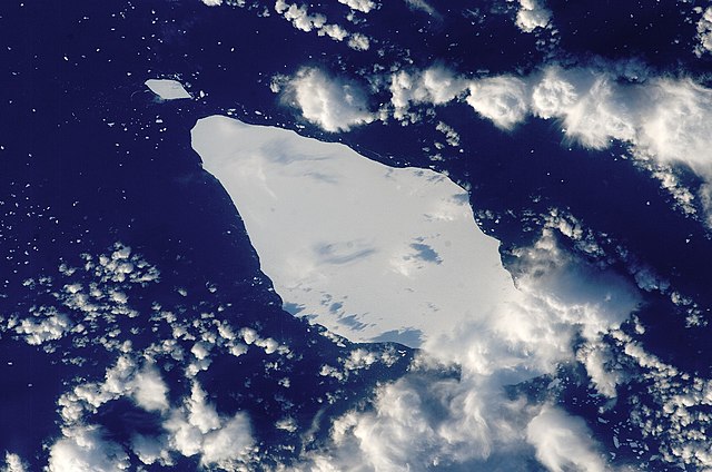
English: This astronaut photograph illustrates the remains of a giant iceberg—designated A22A— that broke off Antarctica in 2002. The iceberg was photographed at a location of 49.9 degrees south latitude, 23.8 degrees west longitude, which is about a third of the distance from South America towards Cape Town, South Africa. A22A is one of the largest icebergs to drift as far north as 50 degrees south latitude, bringing it beneath the daylight path of the International Space Station (ISS). Crew members aboard the ISS were able to locate the ice mass and photograph it, despite the great masses of clouds that often accompany winter storms in the Southern Ocean. The crew’s viewing angle was oblique (not looking straight down) from a point to the west of the berg, and the time of day was early afternoon, as shown by the orientation of the cloud shadows. Dimensions of A22A in early June were 49.9 by 23.4 kilometres, giving it an area of 622 square kilometres, or seven times the area of Manhattan Island.
ISS Crew Earth Observations: ISS015-E-10125
Identification
Mission
ISS015 (Expedition 15)
Roll
E
Frame
10125
Country or Geographic Name
ATLANTIC OCEAN
Features
A22A ICEBERG, SMALL ICEBERGS
Center Point Latitude
-48.8° N
Center Point Longitude
-24.0° E
Camera
Camera Tilt
43°
Camera Focal Length
180 mm
Camera
Kodak DCS760C Electronic Still Camera
Film
3060 x 2036 pixel CCD, RGBG array.
Quality
Percentage of Cloud Cover
26-50%
Nadir What is Nadir?
Date
2007-05-30
Time
14:46:44
Nadir Point Latitude
-50.5° N
Nadir Point Longitude
-21.8° E
Nadir to Photo Center Direction
Northwest
Sun Azimuth
340°
Spacecraft Altitude
181 nautical miles (335 km)
Sun Elevation Angle
16°
Orbit Number
799
วันที่
แหล่งที่มา
{{URL|example.com|optional display text}}
ผู้สร้างสรรค์
Image provided by the ISS Crew Earth Observations experiment and the Image Science & Analysis Laboratory, NASA - Johnson Space Center.
This image or video was catalogued by Johnson Space Center of the United States National Aeronautics and Space Administration (NASA) under Photo ID: ISS015-E-10125.
This tag does not indicate the copyright status of the attached work. A normal copyright tag is still required.See Commons:Licensing.العربية ∙ беларуская (тарашкевіца) ∙ български ∙ català ∙ čeština ∙ dansk ∙ Deutsch ∙ English ∙ español ∙ فارسی ∙ français ∙ galego ∙ magyar ∙ հայերեն ∙ Bahasa Indonesia ∙ italiano ∙ 日本語 ∙ македонски ∙ മലയാളം ∙ Nederlands ∙ polski ∙ português ∙ русский ∙ sicilianu ∙ Türkçe ∙ українська ∙ 简体中文 ∙ 繁體中文 ∙ +/−
{{Information |Description={{en|1=This astronaut photograph illustrates the remains of a giant iceberg—designated A22A— that broke off Antarctica in 2002. The iceberg was photographed at a location of 49.9 degrees south latitude, 23.8 degrees west lon
Scienze della Terra per le superiori/I movimenti delle acque oceaniche
การใช้บน it.wikiversity.org
I movimenti delle acque oceaniche (superiori)
பனிமலை
มกราคม 20, 2023
ไฟล, iceberg, a22a, south, atlantic, ocean, ไฟล, ประว, ไฟล, หน, าท, ภาพน, การใช, ไฟล, วนกลางขนาดของต, วอย, างน, กเซล, ความละเอ, ยดอ, กเซล, กเซล, กเซล, กเซล, กเซล, ภาพท, ความละเอ, ยดส, งกว, 8206, กเซล, ขนาดไฟล, โลไบต, ชน, ดไมม, image, jpeg, ปภาพหร, อไฟล, เส, ยง. ifl prawtiifl hnathimiphaphni karichiflswnklangkhnadkhxngtwxyangni 800 530 phikesl khwamlaexiydxun 320 212 phikesl 640 424 phikesl 1 024 678 phikesl 1 280 848 phikesl 2 345 1 553 phikesl duphaphthimikhwamlaexiydsungkwa 8206 2 345 1 553 phikesl khnadifl 793 kiolibt chnidimm image jpeg rupphaphhruxiflesiyngni tnchbbxyuthi khxmmxns raylaexiyddanlang epnkhxkhwamthiaesdngphlcak ifltnchbbinkhxmmxns khxmmxnsepnewbistinokhrngkarsahrbekbrwbrwmsuxesri thi khunsamarthchwyid khwamyx khaxthibayIceberg A22A South Atlantic Ocean jpg English This astronaut photograph illustrates the remains of a giant iceberg designated A22A that broke off Antarctica in 2002 The iceberg was photographed at a location of 49 9 degrees south latitude 23 8 degrees west longitude which is about a third of the distance from South America towards Cape Town South Africa A22A is one of the largest icebergs to drift as far north as 50 degrees south latitude bringing it beneath the daylight path of the International Space Station ISS Crew members aboard the ISS were able to locate the ice mass and photograph it despite the great masses of clouds that often accompany winter storms in the Southern Ocean The crew s viewing angle was oblique not looking straight down from a point to the west of the berg and the time of day was early afternoon as shown by the orientation of the cloud shadows Dimensions of A22A in early June were 49 9 by 23 4 kilometres giving it an area of 622 square kilometres or seven times the area of Manhattan Island ISS Crew Earth Observations ISS015 E 10125 IdentificationMission ISS015 Expedition 15 Roll EFrame 10125Country or Geographic Name ATLANTIC OCEANFeatures A22A ICEBERG SMALL ICEBERGSCenter Point Latitude 48 8 NCenter Point Longitude 24 0 ECameraCamera Tilt 43 Camera Focal Length 180 mmCamera Kodak DCS760C Electronic Still CameraFilm 3060 x 2036 pixel CCD RGBG array QualityPercentage of Cloud Cover 26 50 Nadir What is Nadir Date 2007 05 30Time 14 46 44Nadir Point Latitude 50 5 NNadir Point Longitude 21 8 ENadir to Photo Center Direction NorthwestSun Azimuth 340 Spacecraft Altitude 181 nautical miles 335 km Sun Elevation Angle 16 Orbit Number 799wnthi 18 mithunayn ph s 2550aehlngthima URL example com optional display text phusrangsrrkh Image provided by the ISS Crew Earth Observations experiment and the Image Science amp Analysis Laboratory NASA Johnson Space Center taaehnngkhxngwtthuhruxsthanthi48 48 00 it 24 00 00 tawntk phaphniaelaphaphxun n sthanthiediywknthi OpenStreetMap 48 800000 24 000000This image or video was catalogued by Johnson Space Center of the United States National Aeronautics and Space Administration NASA under Photo ID ISS015 E 10125 This tag does not indicate the copyright status of the attached work A normal copyright tag is still required See Commons Licensing العربية belaruskaya tarashkevica blgarski catala cestina dansk Deutsch English espanol فارسی francais galego magyar հայերեն Bahasa Indonesia italiano 日本語 makedonski മലയ ള Nederlands polski portugues russkij sicilianu Turkce ukrayinska 简体中文 繁體中文 karxnuyatichsiththi Public domain Public domain false falsephaphniepnsatharnsmbti enuxngcakepnphaphthisrangkhunodyxngkhkarbriharkarbinaelaxwkasaehngchati NASA sungtamnoybaydanlikhsiththikhxngnasarabuiwwa phaphaelasuxtang khxngnasaimidrbkarkhumkhrxngodylikhsiththiykewncarabuiwwamilikhsiththi duephimthi hnanoybaydanlikhsiththikhxngnasa hrux noybaykarichphaphkhxng JPLkhaetuxn karich olokkhxngnasa ekhruxnghmayaelaekhruxngpradbkhxngnasa thukcakddwykdhmayshrthxemrikainlksna 14 khxngkhxbngkhbthangrachkarshrthxemrika swnthi 1221 ewbistkhxngnasaekbrwbrwmphaphthimacakxngkhkarxwkasosewiyt xngkhkarxwkasaehngchatirsesiy aelaxngkhkarxwkasthimiichxngkhkarxwkaskhxngshrthxemrika epncanwnmak phaphehlaniimcaepntxngepnsatharnsmbtiesmxip phaphhruxsuxthimacak klxngothrthrrsnxwkashbebil xacmilikhsiththi hakphaphhruxsuxnnimidrabuchdecnwamacak sthabnwithyasastrklxngothrthrrsnxwkas 1 phaphhruxsuxthnghmdthimacakekhruxngmuxkhxng okhrngkarsuksadwngxathityaelalmsuriya milikhsiththi karnaphaphhruxsuxcakokhrngkaripichnxkehnuxcakkarichephuxkarkhahruxephuxkarsuksa txngidrbxnuyatkxn 2 phaphthithukkhdeluxkihepn phaphdarasastrpracawn APOD bnewbistkhxng APOD xacmilikhsiththi 3 khabrryayodyyxithyephimkhabrryaythrrthdediywephuxkhyaykhwamwaiflnimixairixethmthiaesdngxyuiniflniprakxbdwysthanalikhsiththisatharnsmbtidetermination method xngkvs work of the federal government of the United States xngkvswnthisrang wnkxtng18 mithunayn 2007coordinates of depicted place xngkvs48 48 S 24 0 Wcatalog code xngkvsISS015 E 10125aekhttalxk Media catalogue of the Johnson Space Center xngkvsehtukarnsakhyExpedition 15 xngkvs prawtiifl khlikwnthi ewlaephuxduiflthipraktinkhnann wnthi ewlarupyxkhnadphuichkhwamehn pccubn22 25 22 minakhm 25562 345 1 553 793 kiolibt Julian HerzogHigher resolution and quality 02 54 6 krkdakhm 25521 000 1 000 376 kiolibt Originalwana Information Description en 1 This astronaut photograph illustrates the remains of a giant iceberg designated A22A that broke off Antarctica in 2002 The iceberg was photographed at a location of 49 9 degrees south latitude 23 8 degrees west lon hnathimiphaphni hnatxipni oyngmathiphaphni phuekhanaaekhng karichiflswnklang wikixuntxipniichiflni karichbn ar wikipedia org المحيط الأطلسي karichbn az wikipedia org Atlantik okean karichbn bar wikipedia org Atlantischa Ozean karichbn bn wikipedia org আটল ন ট ক মহ স গর karichbn cy wikipedia org Cefnfor yr Iwerydd karichbn en wikipedia org Atlantic Ocean Iceberg Portal Oceans karichbn eo wikipedia org Atlantiko karichbn it wikipedia org Iceberg karichbn it wikibooks org Scienze della Terra per le superiori I movimenti delle acque oceaniche karichbn it wikiversity org I movimenti delle acque oceaniche superiori karichbn la wikipedia org Oceanus Atlanticus karichbn mk wikipedia org Santa karichbn pt wikipedia org Iceberg karichbn sl wikipedia org Atlantski ocean karichbn ta wikipedia org பன மல karichbn ta wiktionary org ice berg பன மல ekhathungcak https th wikipedia org wiki ifl Iceberg A22A South Atlantic Ocean jpg, wikipedia, วิกิ หนังสือ, หนังสือ, ห้องสมุด,