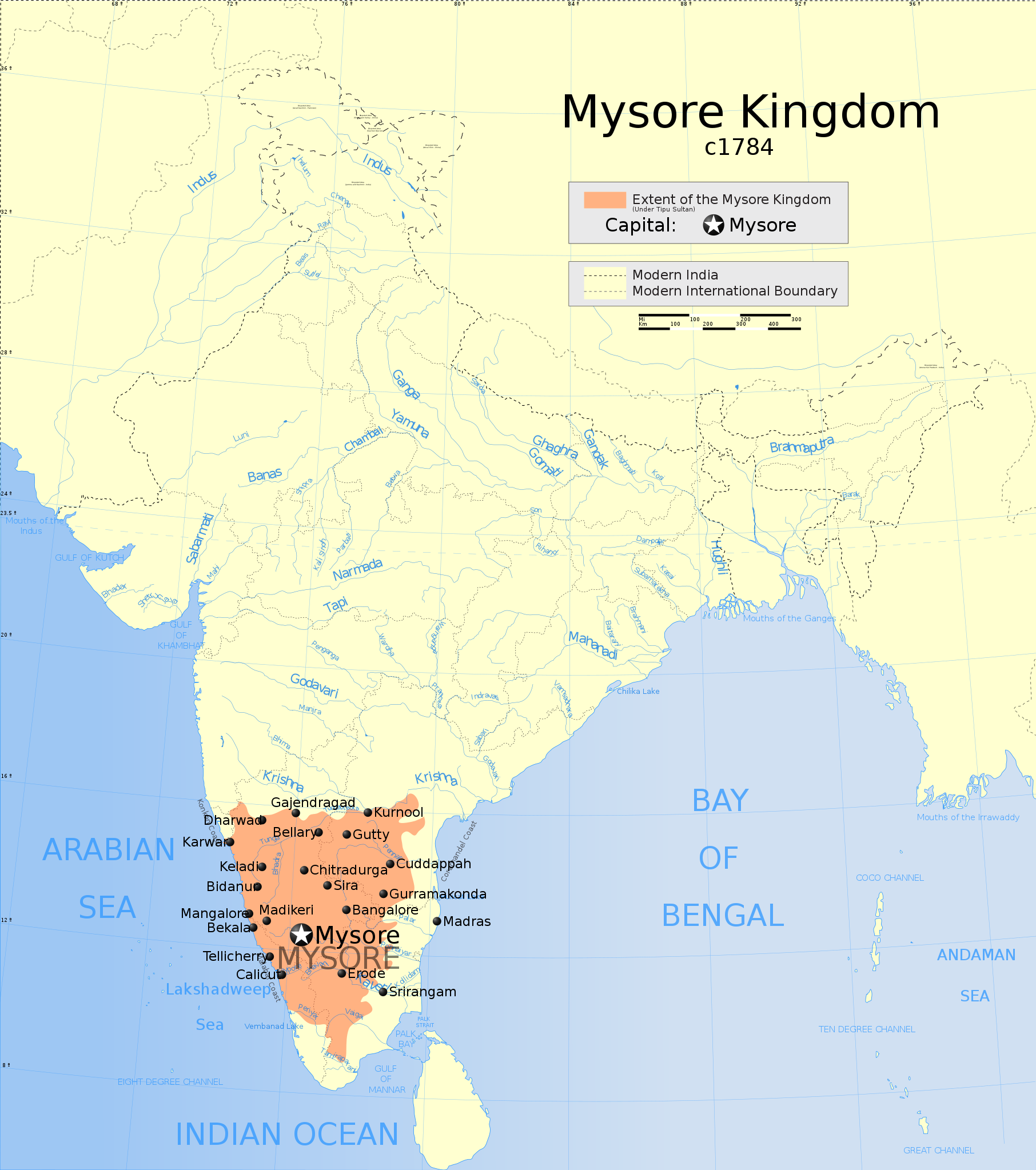
Map showing the extent of the Mysore Kingdom under Tipu Sultan including the Keladi Kingdom.
Extent of Mysore Kingdom including Keladi, c1780
คำอธิบายแผนที่
วันที่
แหล่งที่มา
งานของตัว International Borders: University of Texas map library - India Political map 2001 Disputed Borders: University of Texas map library - China-India Borders - Eastern Sector 1988 & Western Sector 1988 - Kashmir Region 2004 - Kashmir Maps. State and District boundaries: Census of India - 2001 Census State Maps - Survey of India Maps. Other sources: US Army Map Service, Survey of India Map Explorer, Columbia University
Map specific sources: "Suryanath U. Kamat, A Concise history of Karnataka from pre-historic times to the present, Jupiter books, MCC, Bangalore, 2001 (Reprinted 2002) OCLC: 7796041" Page 330.
If you are using the image under the creative commons share alike license please credit the photo CC-by-sa PlaneMad/Wikimedia and include a link to this page. No explicit permission is needed from me, but id appreciate an email if my work has been of help to you.
If you dont want to release your work under a creative commons license, please mail me at arun.planemad@gmail.com or catch me at my Website to negotiate a custom license as per your needs.
The frontiers depicted on the Indian maps in Wikipedia are from a neutral point of view and may differ from official government maps of India, Pakistan and China. Please consult local laws governing publication of maps before usage.
The territorial boundaries of India are shown as per the actual ground situation in accordance with international practices followed by the United Nations ([1], ) and the National Geographic Society (, [4])
This map is meant to be for illustrative purpose only and is not authenticated by official government sources. Please check the list of sources and references used to create the map for a measure of accuracy and verifiability.
The usage of these maps in India, Pakistan and China are governed by different laws that restrict depictions of boundaries other than what is officially recognized by the state. Please check local laws and modify the map accordingly before use.
Explanation of disputed boundaries
Boundary of Indian claim : The territory India claims is legally theirs, but the claim is disputed by China and Pakistan.
Line of Control/Line of Conflict : The de facto administrative boundary recognised by the international community. This UN ceasefire line is considered as a temporary solution to an ongoing conflict since the departure of the British Raj.
Borders of disputed regions
The depicted extent of the former territory of the British Indian Empire, succeeded by Republic of India, may not be accepted by few countries as legal due to ongoing border disputes:
The northern Himalayan region of the disputed territory Indian-administered Kashmir is claimed by India including (Pakistan-administered Kashmir) and the Chinese-occupied territory of (Ladakh plateau). Since 1972, it is divided between all three countries. See also Line of Control and Line of Actual Control.
Siachen glacier (shown white) is an actively contested region between India and Pakistan. Since 1984, the region is under Indian control.
The northeastern territory of Arunachal Pradesh is almost entirely claimed by China as part of its Tibetan territory.
Minor areas of eastern Kashmir's Ladakh division, Himachal Pradesh and Uttarakhand on the Chinese frontier are claimed by China. These areas are under Indian control.
A small area of Uttarakhand adjoining the Nepal border along the Sarda river is disputed between the two countries.
For a detailed map of all disputed regions in South Asia, see Image:India disputed areas map.svg
Internal borders
The borders of the state of Meghalaya, Assam and Arunachal Pradesh are shown as interpreted from the North-Eastern Areas (Reorganisation) Act, 1971, but has yet to be verified.
Territorial waters
The limit of the territorial waters of India extends to twelve nautical miles measured from the appropriate baseline. See this for more information.
{{WikiProject_India_Maps |Title=The Mysore Kingdom c1784 |Description=Map showing the extent of the Mysore Kingdom under Tipu Sultan including the Keladi Kingdom. {{legend|#FF9F80|Extent of Mysore Kingdom including Keladi, c780}} |Source= "Suryanath U. Ka
ไฟล, indian, mysore, kingdom, 1784, ไฟล, ประว, ไฟล, หน, าท, ภาพน, การใช, ไฟล, วนกลางขนาดของต, วอย, าง, ของไฟล, กเซล, ความละเอ, ยดอ, กเซล, กเซล, กเซล, กเซล, กเซล, กเซล, ภาพท, ความละเอ, ยดส, งกว, 8206, ไฟล, กเซล, ขนาดไฟล, โลไบต, ปภาพหร, อไฟล, เส, ยงน, นฉบ, บอย, . ifl prawtiifl hnathimiphaphni karichiflswnklangkhnadkhxngtwxyang PNG nikhxngifl SVG ni 530 599 phikesl khwamlaexiydxun 212 240 phikesl 425 480 phikesl 680 768 phikesl 906 1 024 phikesl 1 812 2 048 phikesl 1 639 1 852 phikesl duphaphthimikhwamlaexiydsungkwa 8206 ifl SVG 1 639 1 852 phikesl khnadifl 476 kiolibt rupphaphhruxiflesiyngni tnchbbxyuthi khxmmxns raylaexiyddanlang epnkhxkhwamthiaesdngphlcak ifltnchbbinkhxmmxns khxmmxnsepnewbistinokhrngkarsahrbekbrwbrwmsuxesri thi khunsamarthchwyid chuxeruxng The Mysore Kingdom c1784khaxthibayIndian Mysore Kingdom 1784 map svg Map showing the extent of the Mysore Kingdom under Tipu Sultan including the Keladi Kingdom Extent of Mysore Kingdom including Keladi c1780khaxthibayaephnthiwnthi tulakhm ph s 2550aehlngthima ngankhxngtw International Borders University of Texas map library India Political map 2001Disputed Borders University of Texas map library China India Borders Eastern Sector 1988 amp Western Sector 1988 Kashmir Region 2004 Kashmir Maps State and District boundaries Census of India 2001 Census State Maps Survey of India Maps Other sources US Army Map Service Survey of India Map Explorer Columbia University Map specific sources Suryanath U Kamat A Concise history of Karnataka from pre historic times to the present Jupiter books MCC Bangalore 2001 Reprinted 2002 OCLC 7796041 Page 330 phusrang This Image was created byUser PlaneMad If you are using the image under the creative commons share alike license please credit the photo CC by sa PlaneMad Wikimedia and include a link to this page No explicit permission is needed from me but id appreciate an email if my work has been of help to you If you dont want to release your work under a creative commons license please mail me at arun planemad gmail com or catch me at my Website to negotiate a custom license as per your needs karxnuyat karichiflniihm khapheca inthanaphuthuxlikhsiththikhxngphaphhruxsuxni xnuyatihichphaphhruxsuxniphayitenguxnikhtxipniiflnixyuphayitsyyaxnuyat khriexthifkhxmmxns aebbaesdngthima xnuyataebbediywkn 3 0 tnchbbkhunsamarth thicaaebngpn thicathasaena aeckcay aelasngngandngklawtxip thicaeriyberiyngihm thicaddaeplngngandngklaw phayitenguxnikhtxipni aesdngthima khuntxngihekiyrtiecakhxngnganxyangehmaasm odyephimlingkipyngsyyaxnuyat aelarabuhakmikarepliynaeplng khunxacthaechnniidinrupaebbidkidtamkhwr aettxngimichinlksnathiaenawaphuihxnuyatsnbsnunkhunhruxkarichngankhxngkhun xnuyataebbediywkn hakkhunddaeplng epliynrup hruxtxetimnganni khuntxngichsyyaxnuyataebbediywknhruxaebbthiehmuxnkbsyyaxnuyatthiichkbnganniethannhttps creativecommons org licenses by sa 3 0 CC BY SA 3 0 Creative Commons Attribution Share Alike 3 0 true trueThe frontiers depicted on the Indian maps in Wikipedia are from a neutral point of view and may differ from official government maps of India Pakistan and China Please consult local laws governing publication of maps before usage Geotemporal dataDate depicted second half of 20 century aela 21 centurySpatial reference system conickhxbekht 38 04 N 64 13 E 38 06 N 64 21 E 38 06 64 21 38 34 N 100 03 E 38 57 N 100 05 E 38 57 100 055 07 N 68 26 E 5 12 N 68 44 E 5 12 68 44 5 36 N 96 52 E 5 60 N 96 87 E 5 60 96 87phikdxangxingthangphumisastr rabuphikdbnaephnthi Wikimaps Warper thamikhwamimehmaasm krunatng warp status skip ephuxsxn Archival datahmayehtu Part of WikiProject India Maps enuxha 1 Notes 1 1 Depiction of India s borders 1 2 Explanation of disputed boundaries 1 3 Borders of disputed regions 1 4 Internal borders 1 5 Territorial waters Notes Depiction of India s borders The territorial boundaries of India are shown as per the actual ground situation in accordance with international practices followed by the United Nations 1 2 and the National Geographic Society 3 4 This map is meant to be for illustrative purpose only and is not authenticated by official government sources Please check the list of sources and references used to create the map for a measure of accuracy and verifiability The usage of these maps in India Pakistan and China are governed by different laws that restrict depictions of boundaries other than what is officially recognized by the state Please check local laws and modify the map accordingly before use Explanation of disputed boundaries Boundary of Indian claim The territory India claims is legally theirs but the claim is disputed by China and Pakistan Line of Control Line of Conflict The de facto administrative boundary recognised by the international community This UN ceasefire line is considered as a temporary solution to an ongoing conflict since the departure of the British Raj Borders of disputed regions The depicted extent of the former territory of the British Indian Empire succeeded by Republic of India may not be accepted by few countries as legal due to ongoing border disputes The northern Himalayan region of the disputed territory Indian administered Kashmir is claimed by India including Pakistan administered Kashmir and the Chinese occupied territory of Ladakh plateau Since 1972 it is divided between all three countries See also Line of Control and Line of Actual Control Siachen glacier shown white is an actively contested region between India and Pakistan Since 1984 the region is under Indian control The northeastern territory of Arunachal Pradesh is almost entirely claimed by China as part of its Tibetan territory Minor areas of eastern Kashmir s Ladakh division Himachal Pradesh and Uttarakhand on the Chinese frontier are claimed by China These areas are under Indian control A small area of Uttarakhand adjoining the Nepal border along the Sarda river is disputed between the two countries For a detailed map of all disputed regions in South Asia see Image India disputed areas map svg Internal borders The borders of the state of Meghalaya Assam and Arunachal Pradesh are shown as interpreted from the North Eastern Areas Reorganisation Act 1971 but has yet to be verified Territorial waters The limit of the territorial waters of India extends to twelve nautical miles measured from the appropriate baseline See this for more information khabrryayodyyxithyephimkhabrryaythrrthdediywephuxkhyaykhwamwaiflnimixairixethmthiaesdngxyuiniflniprakxbdwysthanalikhsiththimilikhsiththisyyaxnuyatCreative Commons Attribution ShareAlike 3 0 Unported xngkvsthimakhxngiflkarsrangdngedimodyphuxpohld prawtiifl khlikwnthi ewlaephuxduiflthipraktinkhnann wnthi ewlarupyxkhnadphuichkhwamehn pccubn14 54 12 tulakhm 25501 639 1 852 476 kiolibt Planemad WikiProject India Maps Title The Mysore Kingdom c1784 Description Map showing the extent of the Mysore Kingdom under Tipu Sultan including the Keladi Kingdom legend FF9F80 Extent of Mysore Kingdom including Keladi c780 Source Suryanath U Ka hnathimiphaphni hnatxipni oyngmathiphaphni rachxanackrimsuru karichiflswnklang wikixuntxipniichiflni karichbn ar wikipedia org مملكة ميسور karichbn azb wikipedia org میسور شاهلیغی karichbn bg wikipedia org Majsor karichbn bn wikipedia org মহ শ র র জ য karichbn br wikipedia org Rouantelezh Maisor karichbn ca wikipedia org Regne de Mysore karichbn cs wikipedia org Maisurske kralovstvi karichbn da wikipedia org Kongeriget Mysore karichbn en wikipedia org Islamic rulers in the Indian subcontinent Wadiyar dynasty Kingdom of Mysore Political history of medieval Karnataka User Tisquesusa sandbox9 karichbn eo wikipedia org Majsura reĝlando karichbn fa wikipedia org پادشاهی میسور karichbn fi wikipedia org Mysoren kuningaskunta karichbn fr wikipedia org Royaume de Mysore karichbn he wikipedia org ממלכת מייסור karichbn hu wikipedia org Maiszuri Kiralysag India uralkodoinak listaja karichbn id wikipedia org Kerajaan Mysore karichbn it wikipedia org Regno di Mysore karichbn ja wikipedia org マイソール王国 karichbn ka wikipedia org მაისურის სამეფო karichbn kn wikipedia org ಮ ಸ ರ ಸ ಸ ಥ ನ karichbn ml wikipedia org മ സ ർ ര ജ യ karichbn mr wikipedia org म ह स रच र जत त र karichbn ms wikipedia org Kerajaan Mysore karichbn no wikipedia org Kongedommet Mysore karichbn pl wikipedia org Majsur karichbn pnb wikipedia org ریاست میسور سلطنت خداداد میسور karichbn pt wikipedia org Reino de Maicor karichbn ru wikipedia org Majsur gosudarstvo karichbn sa wikipedia org म स र स स थ नम karichbn simple wikipedia org Kingdom of Mysore karichbn si wikipedia org මය ස ර ර ජධ න ය karichbn sv wikipedia org Mysore furstendome karichbn ta wikipedia org ம ச ர அரச karichbn te wikipedia org మ స ర స మ ర జ య karichbn tr wikipedia org Maisur Kralligi karichbn uk wikipedia org Majsur knyazivstvo karichbn ur wikipedia org سلطنت خداداد میسور ریاست میسور karichbn uz wikipedia org Maysur karichbn vi wikipedia org Vương quốc Mysore karichbn www wikidata org Q266923 karichbn zh min nan wikipedia org Mysore Ong kok karichbn zh wikipedia org 迈索尔王国 ekhathungcak https th wikipedia org wiki ifl Indian Mysore Kingdom 1784 map svg, wikipedia, วิกิ หนังสือ, หนังสือ, ห้องสมุด,