This map is available from the United States Library of Congress's Geography & Map Division under the digital ID g8070.ct000982. This tag does not indicate the copyright status of the attached work. A normal copyright tag is still required. See Commons:Licensing for more information.
العربية ∙ беларуская (тарашкевіца) ∙ čeština ∙ Deutsch ∙ English ∙ español ∙ فارسی ∙ suomi ∙ français ∙ galego ∙ עברית ∙ magyar ∙ Bahasa Indonesia ∙ italiano ∙ 日本語 ∙ lietuvių ∙ македонски ∙ മലയാളം ∙ Nederlands ∙ polski ∙ português ∙ português do Brasil ∙ română ∙ русский ∙ sicilianu ∙ slovenčina ∙ slovenščina ∙ Türkçe ∙ українська ∙ 中文(简体) ∙ 中文(繁體) ∙ +/−
ผู้สร้างสรรค์
Central Intelligence Agency, United States of America
เวอร์ชันอื่น
ภาพแผนที่นี้ ควรจะถูกสร้างใหม่เป็นกราฟิกส์เวกเตอร์ ซึ่งมีข้อดีอีกหลายประการ ดูเพิ่มเติมที่คอมมอนส์:สื่อต้องการเก็บกวาดสำหรับสารสนเทศเพิ่มเติม หากภาพนี้มีในรูปแบบกราฟิกส์เวกเตอร์อยู่แล้ว กรุณาอัปโหลดและแทนที่แม่แบบนี้ด้วย {{vector version available|ชื่อภาพใหม่}} แนะนำเป็นอย่างยิ่งให้ตั้งชื่อไฟล์เวกเตอร์ใหม่นั้นในรูปแบบ "Indonesia 2002 CIA map.svg" แล้วใส่แม่แบบ Vector version available (หรือ Vva) ซึ่งไม่ต้องใช้พารามิเตอร์ ชื่อภาพใหม่
This map image was uploaded in the JPEG format even though it consists of non-photographic data. This information could be stored more efficiently or accurately in the PNG or SVG format. If possible, please upload a PNG or SVG version of this image without compression artifacts, derived from a non-JPEG source (or with existing artifacts removed). After doing so, please tag the JPEG version with {{Superseded|NewImage.ext}} and remove this tag. This tag should not be applied to photographs or scans. For more information, see {{BadJPEG}}.
การอนุญาตใช้สิทธิ
Public domainPublic domainfalsefalse
Original description
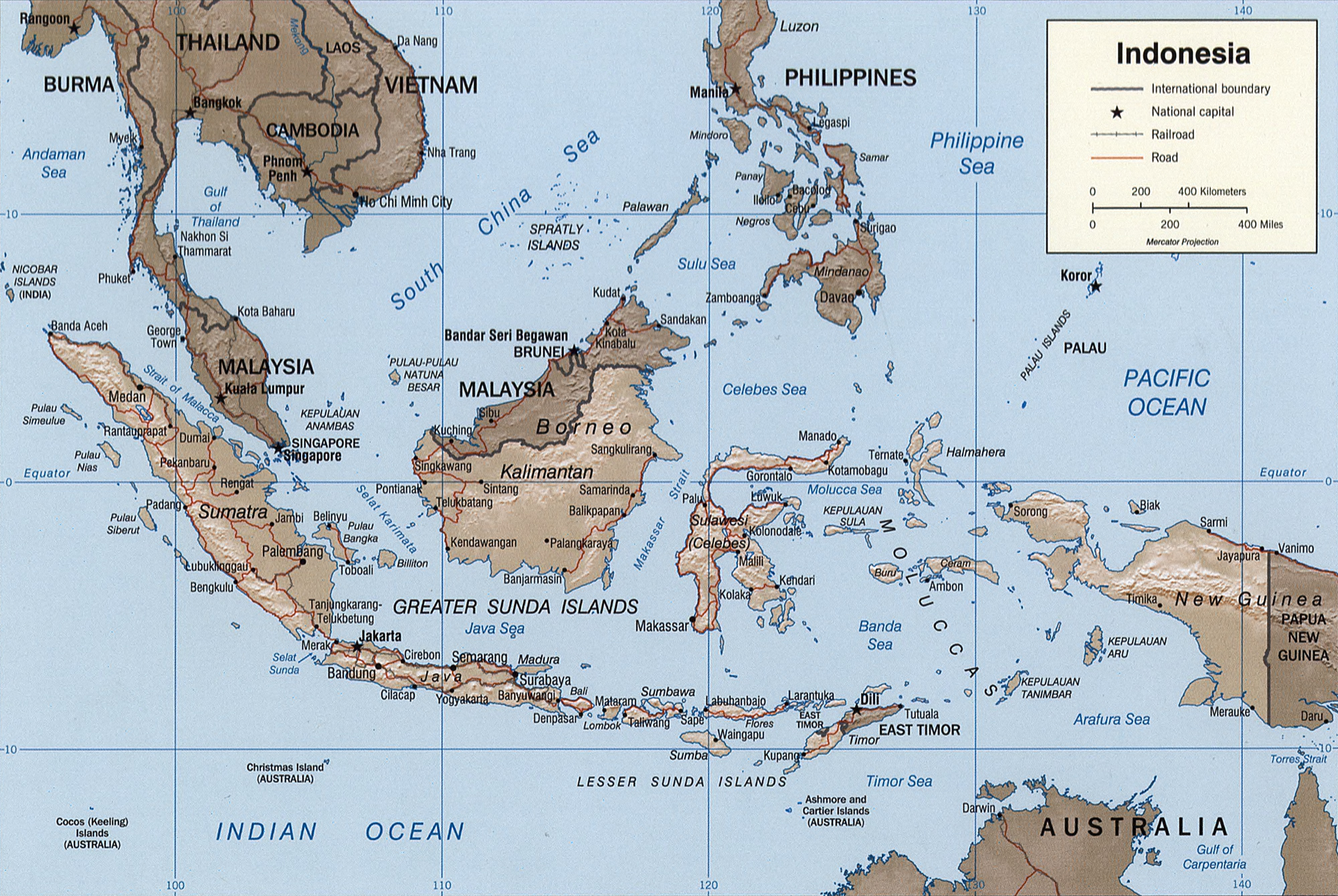
Indonesia.
United States. Central Intelligence Agency.
CREATED/PUBLISHED
[Washington, D.C. : Central Intelligence Agency, 2002]
Indonesia. United States. Central Intelligence Agency. CREATED/PUBLISHED [Washington, D.C. : Central Intelligence Agency, 2002] NOTES Relief shown by shading. "Base 802899AI (C00429) 11-02." Also issued without shaded relief. Scale [ca. 1:25,000,000
ไฟล, indonesia, 2002, ไฟล, ประว, ไฟล, หน, าท, ภาพน, การใช, ไฟล, วนกลาง, อม, ลเก, ยวก, บภาพขนาดของต, วอย, างน, กเซล, ความละเอ, ยดอ, กเซล, กเซล, กเซล, กเซล, กเซล, ภาพท, ความละเอ, ยดส, งกว, 8206, กเซล, ขนาดไฟล, เมกะไบต, ชน, ดไมม, image, jpeg, ปภาพหร, อไฟล, เส, ยง. ifl prawtiifl hnathimiphaphni karichiflswnklang khxmulekiywkbphaphkhnadkhxngtwxyangni 800 536 phikesl khwamlaexiydxun 320 214 phikesl 640 429 phikesl 1 024 686 phikesl 1 280 858 phikesl 2 000 1 340 phikesl duphaphthimikhwamlaexiydsungkwa 8206 2 000 1 340 phikesl khnadifl 1 43 emkaibt chnidimm image jpeg rupphaphhruxiflesiyngni tnchbbxyuthi khxmmxns raylaexiyddanlang epnkhxkhwamthiaesdngphlcak ifltnchbbinkhxmmxns khxmmxnsepnewbistinokhrngkarsahrbekbrwbrwmsuxesri thi khunsamarthchwyid enuxha 1 khwamyx 2 karxnuyatichsiththi 3 Original description 3 1 Indonesia 3 2 CREATED PUBLISHED 3 3 NOTES 3 4 SUBJECTS 3 5 MEDIUM 3 6 CALL NUMBER 3 7 REPOSITORY 3 8 DIGITAL ID khwamyx khaxthibayIndonesia 2002 CIA map jpg English Map of Indonesia Francais Carte d Indonesie wnthi ph s 2545aehlngthima hxsmudrthspha chuxinphasatnchbb Library of Congressthitng wxchingtn di si shrthxemrikaphikd 38 53 18 ehnux 77 00 16 tawntk cdtngkhunemux 24 emsayn ph s 2343 ewbephc loc gov ngankhwbkhumraykarhlkthan Q131454 VIAF 151962300 ISNI 0000 0001 2186 288X ULAN 500312782 Open Library OL19454A LCCN n78089035 WorldCat institution QS P195 Q131454 This map is available from the United States Library of Congress s Geography amp Map Division under the digital ID g8070 ct000982 This tag does not indicate the copyright status of the attached work A normal copyright tag is still required See Commons Licensing for more information العربية belaruskaya tarashkevica cestina Deutsch English espanol فارسی suomi francais galego עברית magyar Bahasa Indonesia italiano 日本語 lietuviu makedonski മലയ ള Nederlands polski portugues portugues do Brasil romană russkij sicilianu slovencina slovenscina Turkce ukrayinska 中文 简体 中文 繁體 phusrangsrrkh Central Intelligence Agency United States of Americaewxrchnxun phaphaephnthini khwrcathuksrangihmepnkrafiksewketxr sungmikhxdixikhlayprakar duephimetimthikhxmmxns suxtxngkarekbkwadsahrbsarsnethsephimetim hakphaphnimiinrupaebbkrafiksewketxrxyuaelw krunaxpohldaelaaethnthiaemaebbnidwy vector version available i chuxphaphihm i aenanaepnxyangyingihtngchuxiflewketxrihmnninrupaebb Indonesia 2002 CIA map svg aelwisaemaebb Vector version available hrux Vva sungimtxngichpharamietxr chuxphaphihmThis map image was uploaded in the JPEG format even though it consists of non photographic data This information could be stored more efficiently or accurately in the PNG or SVG format If possible please upload a PNG or SVG version of this image without compression artifacts derived from a non JPEG source or with existing artifacts removed After doing so please tag the JPEG version with Superseded NewImage ext and remove this tag This tag should not be applied to photographs or scans For more information see BadJPEG karxnuyatichsiththi Public domain Public domain false falseThis image is a work of a Central Intelligence Agency employee taken or made as part of that person s official duties As a Work of the United States Government this image or media is in the public domain in the United States cestina Deutsch eesti English espanol francais italiano portugues polski sicilianu slovenscina suomi Tiếng Việt blgarski makedonski russkij ukrayinska ব ল മലയ ള 한국어 日本語 中文 中文 简体 中文 繁體 العربية پښتو Original description Indonesia United States Central Intelligence Agency CREATED PUBLISHED Washington D C Central Intelligence Agency 2002 NOTES Relief shown by shading Base 802899AI C00429 11 02 Also issued without shaded relief Scale ca 1 25 000 000 Mercator proj E 1040 E 1430 N 170 S 150 SUBJECTS Indonesia Maps Indonesia MEDIUM 1 map col 16 x 23 cm CALL NUMBER G8070 2002 U6 REPOSITORY Library of Congress Geography and Map Division Washington D C 20540 4650 USA DIGITAL ID g8070 ct000982 http hdl loc gov loc gmd g8070 ct000982khabrryayodyyxithyephimkhabrryaythrrthdediywephuxkhyaykhwamwaiflnimixairixethmthiaesdngxyuiniflniprakxbdwywnthisrang wnkxtng2002 prawtiifl khlikwnthi ewlaephuxduiflthipraktinkhnann wnthi ewlarupyxkhnadphuichkhwamehn pccubn10 39 26 tulakhm 25482 000 1 340 1 43 emkaibt Brian0918Indonesia United States Central Intelligence Agency CREATED PUBLISHED Washington D C Central Intelligence Agency 2002 NOTES Relief shown by shading Base 802899AI C00429 11 02 Also issued without shaded relief Scale ca 1 25 000 000 hnathimiphaphni hnatxipni oyngmathiphaphni hmuekaasunda karichiflswnklang wikixuntxipniichiflni karichbn ace wikipedia org Pulo pulo Sunda karichbn ar wikipedia org جزر سوندا الصغرى قانون الاختيار الحر karichbn azb wikipedia org سوندا آدالاری karichbn az wikipedia org Zond adalari Indoneziya cografiyasi karichbn bcl wikipedia org Plantilya KanEnotNaPanahon 08 17 karichbn bg wikipedia org Zondski ostrovi karichbn bs wikipedia org Sundska ostrva karichbn da wikipedia org Karimatastraedet Sundaoerne karichbn de wikipedia org Act of Free Choice Sundainseln karichbn el wikipedia org Nhsoi Soyndes karichbn en wikipedia org Act of Free Choice karichbn eo wikipedia org Sundaj Insuloj karichbn es wikipedia org Geografia de Indonesia Islas de la Sonda karichbn eu wikipedia org Indonesiako geografia karichbn fi wikipedia org Sundasaaret karichbn frr wikipedia org Sunda Eilunen karichbn fr wikipedia org Iles de la Sonde Geographie de l Indonesie Amok a Bali Acte de libre choix karichbn fr wiktionary org iles de la Sonde karichbn gl wikipedia org Indonesia Illas da Sonda Borneo karichbn he wikipedia org איי סונדה karichbn hy wikipedia org Զոնդյան կղզիներ karichbn id wikipedia org Penentuan Pendapat Rakyat karichbn id wikisource org Portal Indonesia karichbn is wikipedia org Sundaeyjar karichbn ja wikipedia org ブルネイの歴史 karichbn ka wikipedia org ზონდის კუნძულები karichbn kk wikipedia org Zond araldary karichbn mg wikipedia org Indonezia karichbn ms wikipedia org Skala peta Kepulauan Sunda karichbn nn wikipedia org Karimatasundet karichbn no wikipedia org Karimatastredet karichbn pl wikipedia org Akt Wolnego Wyboru karichbn pl wiktionary org أرخبيل الملايو Archipelag Sundajski Sunda Islands Zondskiya astravy karichbn pt wikipedia org Ilhas da Sonda Fronteira continental Ato de Livre Escolha dukarichthwolkephimetimkhxngiflnikhxmulekiywkbphaph phaphnimikhxmulephimetim sungswnihymacakklxngdicitxlhruxsaeknenxrthisamarthekbkhxmuldngklawiwrwmkbphaphid thaphaphnithukprbprungaekikhhruxepliynaeplngcakedim khxmulbangxyangcayngkhngimepliynaeplngehmuxnphaphthithukprbprungaekikhnnkhwamkwang3 208 phikeslkhwamsung2 468 phikeslrupaebbkarbibxdimidbibxdphikeslkhxmophsichnRGBkarcdwangphaphpkticanwnkhxmophennt3khwamlaexiydaenwnxn72 dpikhwamlaexiydaenwtng72 dpisxftaewrthiichAdobe Photoshop CS2 Windowsaekikhphaphlasud23 38 25 tulakhm 2548sepssiimidprbethiyb ekhathungcak https th wikipedia org wiki ifl Indonesia 2002 CIA map jpg, wikipedia, วิกิ หนังสือ, หนังสือ, ห้องสมุด,