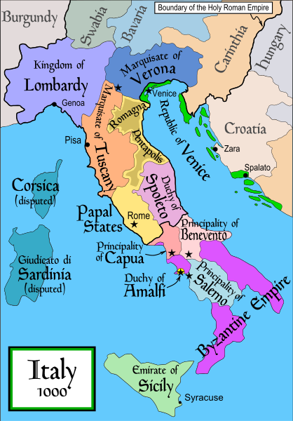
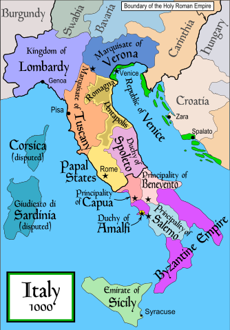
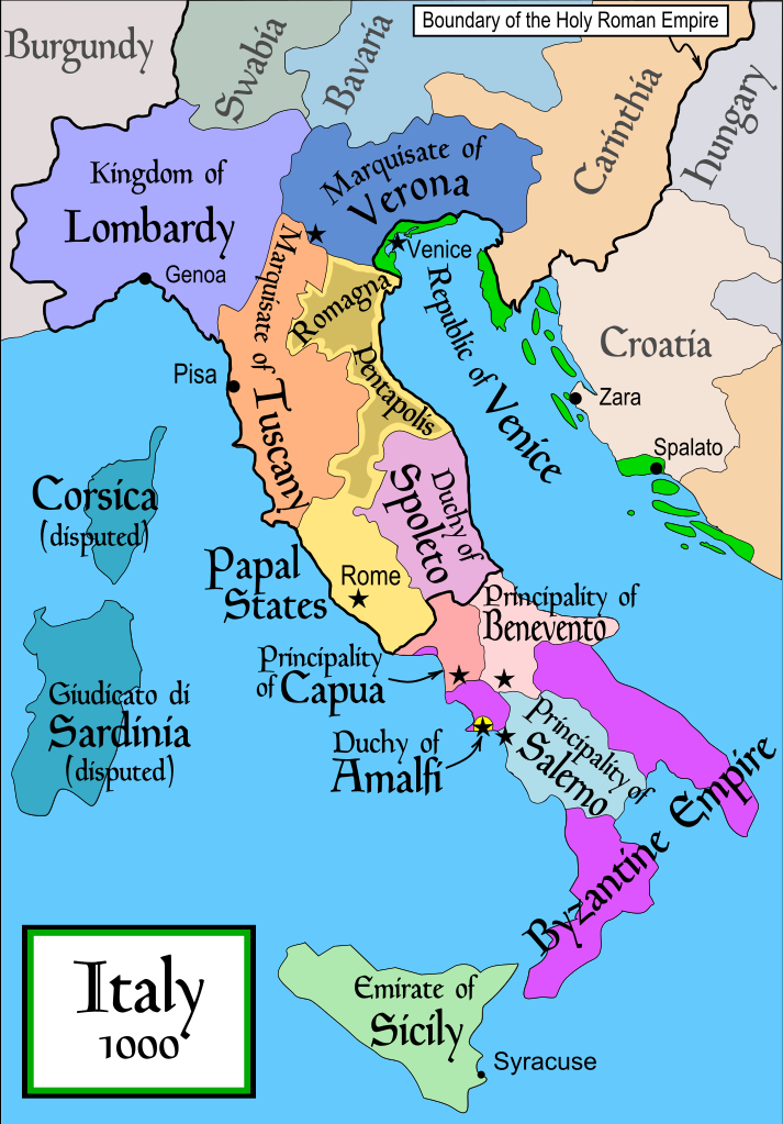
Bjorklund, Oddvar; Holmboe, Haakon; Rohr, Anders (1970) Historical Atlas of the World, Barnes & Noble, NY, SBN: 389-00253-4.
This map from Allyn & Bacon, Longman, textbook publishers.
This map of the w:en:Holy Roman Empire
A map from Attilios
This map of 1050 AD Italy, from the 1923 The Historical Atlas by William R. Shepherd
This map of 1000 AD Italy from Fordham University, adapted from Muir's Historical Atlas, (1911).
In addition, a number of other sources were consulted in an effort to determine the following matters:
The extent of Venetian control over the cities of Dalmatia such as Zara and Spalato. Although the Venetians had been pushed off the mainland earlier, in the period around the year 1000, the Venetians made an effort to recover these cities.
The extent of Saracen control over Corsica and Sardinia. Information is sparse. The apparent situation is that the Muslims had several bases on the coasts of these islands, but did not control the countryside (such as they did in Sicily).
Whether or not the principalities of Capua and Benevento were separate states in the year 1000. Based on lists of their rulers (various Pandulfs and Landulfs), the answer seems to be "yes".
Who controlled the Balkans on the southeastern border of the Kingdom of Croatia. Candidates include Bulgaria, the Byzantine Empire, Croatia, and Serbia.
As noted, there is significant disagreement among sources on these questions.
This map was commissioned by Attilios, and there is also a discussion to be found on MapMaster's English talk page.
ไฟล, italy, 1000, ไฟล, ประว, ไฟล, หน, าท, ภาพน, การใช, ไฟล, วนกลางขนาดของต, วอย, าง, ของไฟล, กเซล, ความละเอ, ยดอ, กเซล, กเซล, กเซล, กเซล, กเซล, กเซล, ภาพท, ความละเอ, ยดส, งกว, 8206, ไฟล, กเซล, ขนาดไฟล, โลไบต, ปภาพหร, อไฟล, เส, ยงน, นฉบ, บอย, คอมมอนส, รายละเอ, . ifl prawtiifl hnathimiphaphni karichiflswnklangkhnadkhxngtwxyang PNG nikhxngifl SVG ni 418 600 phikesl khwamlaexiydxun 167 240 phikesl 334 480 phikesl 535 768 phikesl 713 1 024 phikesl 1 427 2 048 phikesl 565 811 phikesl duphaphthimikhwamlaexiydsungkwa 8206 ifl SVG 565 811 phikesl khnadifl 861 kiolibt rupphaphhruxiflesiyngni tnchbbxyuthi khxmmxns raylaexiyddanlang epnkhxkhwamthiaesdngphlcak ifltnchbbinkhxmmxns khxmmxnsepnewbistinokhrngkarsahrbekbrwbrwmsuxesri thi khunsamarthchwyid enuxha 1 khwamyx 2 References 3 karxnuyatichsiththi 4 derivative works khwamyx khaxthibayItaly 1000 AD svg English Political map of Italy in 1000 AD CE Created by MapMaster Part of a series of maps on the history of Italy 1084 AD 1494 AD 1796 AD 1810 AD wnthi 17 phvscikayn ph s 2549 original upload date aehlngthima No machine readable source provided Own work assumed based on copyright claims phusrangsrrkh No machine readable author provided MapMaster assumed based on copyright claims ewxrchnxun aekikh SVG catala cestina Deutsch English espanol francais Ido italiano magyar polski portugues Turkce russkij ukrayinska العربية עברית 한국어 中文 PNG polski Turkce Ellhnika 中文 ifl SVG nimikhxkhwamthisamarthaeplid odyichekhruxngmuxaepbphasa SVG hruxichtwaekikh SVG idkid sahrbkhxmulephimetim duthiekiywkbkaraeplifl References Bjorklund Oddvar Holmboe Haakon Rohr Anders 1970 Historical Atlas of the World Barnes amp Noble NY SBN 389 00253 4 This map from Allyn amp Bacon Longman textbook publishers This map of the w en Holy Roman Empire A map from Attilios This map of 1050 AD Italy from the 1923 The Historical Atlas by William R Shepherd This map of 1000 AD Italy from Fordham University adapted from Muir s Historical Atlas 1911 In addition a number of other sources were consulted in an effort to determine the following matters The extent of Venetian control over the cities of Dalmatia such as Zara and Spalato Although the Venetians had been pushed off the mainland earlier in the period around the year 1000 the Venetians made an effort to recover these cities The extent of Saracen control over Corsica and Sardinia Information is sparse The apparent situation is that the Muslims had several bases on the coasts of these islands but did not control the countryside such as they did in Sicily Whether or not the principalities of Capua and Benevento were separate states in the year 1000 Based on lists of their rulers various Pandulfs and Landulfs the answer seems to be yes Who controlled the Balkans on the southeastern border of the Kingdom of Croatia Candidates include Bulgaria the Byzantine Empire Croatia and Serbia As noted there is significant disagreement among sources on these questions This map was commissioned by Attilios and there is also a discussion to be found on MapMaster s English talk page karxnuyatichsiththi khapheca inthanaphuthuxlikhsiththikhxngphaphhruxsuxni xnuyatihichphaphhruxsuxniphayitenguxnikhtxipni xnuyatihkhdlxk aeckcayaela hruxddaeprexksarniphayitenguxnikhkhxngsyyaxnuyatexksaresrikhxngknu run 1 2 hruxrunid nbcaknithixxkodymulnithisxftaewresri odyimmiswnidhamaekikh immikhxkhwampkhnaaelapkhlng saenakhxngsyyaxnuyatrwmxyuinswnchux syyaxnuyatexksaresrikhxngknuhttp www gnu org copyleft fdl html GFDL GNU Free Documentation License true true iflnixyuphayitsyyaxnuyat khriexthifkhxmmxns aebbaesdngthima xnuyataebbediywkn 3 0 tnchbb khunsamarth thicaaebngpn thicathasaena aeckcay aelasngngandngklawtxip thicaeriyberiyngihm thicaddaeplngngandngklaw phayitenguxnikhtxipni aesdngthima khuntxngihekiyrtiecakhxngnganxyangehmaasm odyephimlingkipyngsyyaxnuyat aelarabuhakmikarepliynaeplng khunxacthaechnniidinrupaebbidkidtamkhwr aettxngimichinlksnathiaenawaphuihxnuyatsnbsnunkhunhruxkarichngankhxngkhun xnuyataebbediywkn hakkhunddaeplng epliynrup hruxtxetimnganni khuntxngichsyyaxnuyataebbediywknhruxaebbthiehmuxnkbsyyaxnuyatthiichkbnganniethann payaesdngsthanalikhsiththinithukephimephuxihepniptamkarepliynaeplngsyyaxnuyatkhxngmulnithiwikimiediy cak GFDL ipyng GFDL khwbkhukb CC BY SA 3 0 http creativecommons org licenses by sa 3 0 CC BY SA 3 0 Creative Commons Attribution Share Alike 3 0 true true derivative works iflxunthiichiflni nbsp Italya MS 1000 svgkhabrryayodyyxithyephimkhabrryaythrrthdediywephuxkhyaykhwamwaiflnimixairixethmthiaesdngxyuiniflniprakxbdwysthanalikhsiththimilikhsiththisyyaxnuyatGNU Free Documentation License version 1 2 or lateral nbsp xngkvsCreative Commons Attribution ShareAlike 3 0 Unported nbsp xngkvswnthisrang wnkxtng17 phvscikayn 2006MIME type nbsp xngkvsimage svg xml prawtiifl khlikwnthi ewlaephuxduiflthipraktinkhnann wnthi ewlarupyxkhnadphuichkhwamehn pccubn02 50 18 emsayn 2550565 811 861 kiolibt MapMasterSome further changes 12 10 19 kumphaphnth 2550565 811 824 kiolibt MapMasterchanges to ensure consistency with my other Italy maps 12 39 25 phvscikayn 2549565 811 823 kiolibt MapMasterImproved map 21 44 18 phvscikayn 2549565 811 827 kiolibt MapMasterImproved I hope version based on recommendations from Attilios 04 50 18 phvscikayn 2549565 811 768 kiolibt MapMasterPolitical map of Italy in 1000 AD CE hnathimiphaphni hnatxipni oyngmathiphaphni rachxanackrxitali yukhklang karichiflswnklang wikixuntxipniichiflni karichbn an wikipedia org Republica de Pisa karichbn ar wikipedia org ويكيبيديا ورشة الصور أرشيف 4 karichbn ast wikipedia org Republica amalfitana karichbn azb wikipedia org سالرنو سیسیل امیرلیغی karichbn az wikipedia org Siciliya emirliyi Amalfi Respublikasi karichbn bg wikipedia org Romuald II Benevento Knyazhestvo Kapua Hercogstvo Amalfi Spisk na princovete na Salerno Sicilijski emirat karichbn bn wikipedia org আম র ত দক ষ ণ ইত ল ত ইসল ম র ইত হ স স স ল আম র ত karichbn bs wikipedia org Sicilijski Emirat karichbn cs wikipedia org Italie Italske historicke staty Veronske markrabstvi karichbn da wikipedia org Hertuger og prinser af Benevento Basil Boioannes Normanniske erobring af Syditalien karichbn de wikipedia org Diskussion Bulgarien Archiv 1 Wikipedia Kartenwerkstatt Archiv 2007 12 karichbn el wikipedia org Lombardoi Mpenebento Goyaimaros D toy Salerno Katalogos istorikwn kratwn ths Italias Katalogos prigkipwn toy Salerno Katalogos doykwn kai prigkipwn toy Mpenebento Katalogos prigkipwn ths Kapoya karichbn en wikipedia org Lombards Pope Stephen IX Otto III Holy Roman Emperor Otto II Holy Roman Emperor Salerno Benevento Emirate List of historic states of Italy List of state leaders in the 10th century Duchy of Spoleto Duchy of Benevento Kalbids Guaimar IV of Salerno Rainulf Drengot Duchy of Amalfi Emirate of Sicily Sergius IV of Naples List of princes of Capua List of princes of Salerno dukarichthwolkephimetimkhxngiflni ekhathungcak https th wikipedia org wiki ifl Italy 1000 AD svg, wikipedia, วิกิ หนังสือ, หนังสือ, ห้องสมุด,