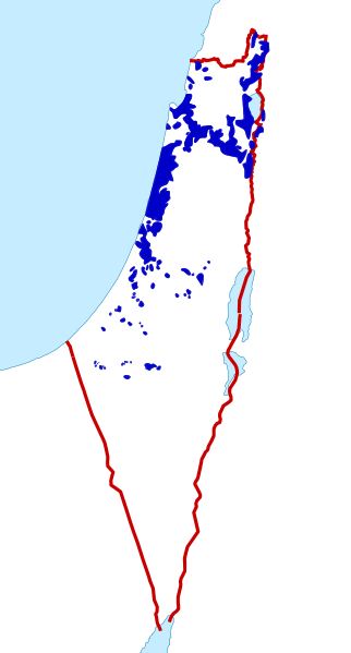
Most of the lands of Mandatory Palestine were owned by either the state public/leased lands (70.6%), foreign owners (6.9%), or religious trusts (3.5%) of the total mandate area, Jewish-owned lands (7.4%) and Arab-owned lands (11.6%).
ความย่อ
คำอธิบายJewish and Arab Land Ownership in Mandatory Palestine, 1947.svg
English: Map showing the areas of Jewish and Arab Land Ownership in Mandatory Palestine, 1947. This information was used during the discussions ahead of the United Nations Partition Plan for Palestine. Note: The white areas within the red line (border for Mandatory Palestine) were owned by either the British state public/leased lands (70.6%), foreign owners (6.9%) or religious trusts (3.5%) of the total mandate area.
Reverted to version as of 05:22, 25 April 2022 (UTC) as version just added was sourced to a blog. An equivalent map does not exist for Palestinian land ownership
ไฟล, jewish, arab, land, ownership, mandatory, palestine, 1947, ไฟล, ประว, ไฟล, หน, าท, ภาพน, การใช, ไฟล, วนกลาง, อม, ลเก, ยวก, บภาพขนาดของต, วอย, าง, ของไฟล, กเซล, ความละเอ, ยดอ, กเซล, กเซล, กเซล, กเซล, กเซล, กเซล, ภาพท, ความละเอ, ยดส, งกว, 8206, ไฟล, กเซล, ข. ifl prawtiifl hnathimiphaphni karichiflswnklang khxmulekiywkbphaphkhnadkhxngtwxyang PNG nikhxngifl SVG ni 322 598 phikesl khwamlaexiydxun 129 240 phikesl 258 480 phikesl 413 768 phikesl 551 1 024 phikesl 1 102 2 048 phikesl 861 1 600 phikesl duphaphthimikhwamlaexiydsungkwa 8206 ifl SVG 861 1 600 phikesl khnadifl 211 kiolibt rupphaphhruxiflesiyngni tnchbbxyuthi khxmmxns raylaexiyddanlang epnkhxkhwamthiaesdngphlcak ifltnchbbinkhxmmxns khxmmxnsepnewbistinokhrngkarsahrbekbrwbrwmsuxesri thi khunsamarthchwyid Most of the lands of Mandatory Palestine were owned by either the state public leased lands 70 6 foreign owners 6 9 or religious trusts 3 5 of the total mandate area Jewish owned lands 7 4 and Arab owned lands 11 6 khwamyx khaxthibayJewish and Arab Land Ownership in Mandatory Palestine 1947 svg English Map showing the areas of Jewish and Arab Land Ownership in Mandatory Palestine 1947 This information was used during the discussions ahead of the United Nations Partition Plan for Palestine Note The white areas within the red line border for Mandatory Palestine were owned by either the British state public leased lands 70 6 foreign owners 6 9 or religious trusts 3 5 of the total mandate area Jewish owned lands 7 4 Arab Palestinian owned lands 11 6 wnthi 2 minakhm ph s 2556aehlngthima http www lib utexas edu maps historical israel hist 1973 jpg http booksand ebooks com political commentary israel palestine land divisionphusrangsrrkh Oncenawhile Dank Chickenewxrchnxun This file was derived from Is map PNG Palestine frontier 1922 png Palestine Index to Villages and Settlements showing Land in Jewish Possession as at 31 12 44 jpg Palestine Arab Refugee Office map showing Jewish owned Land 31 March 1945 jpg ProvincialAutonomyPlan png karxnuyatichsiththi khapheca inthanaphuthuxlikhsiththikhxngphaphhruxsuxni xnuyatihichphaphhruxsuxniphayitenguxnikhtxipniiflnixyuphayitsyyaxnuyat khriexthifkhxmmxns aebbaesdngthima xnuyataebbediywkn 3 0 tnchbbkhunsamarth thicaaebngpn thicathasaena aeckcay aelasngngandngklawtxip thicaeriyberiyngihm thicaddaeplngngandngklaw phayitenguxnikhtxipni aesdngthima khuntxngihekiyrtiecakhxngnganxyangehmaasm odyephimlingkipyngsyyaxnuyat aelarabuhakmikarepliynaeplng khunxacthaechnniidinrupaebbidkidtamkhwr aettxngimichinlksnathiaenawaphuihxnuyatsnbsnunkhunhruxkarichngankhxngkhun xnuyataebbediywkn hakkhunddaeplng epliynrup hruxtxetimnganni khuntxngichsyyaxnuyataebbediywknhruxaebbthiehmuxnkbsyyaxnuyatthiichkbnganniethannhttps creativecommons org licenses by sa 3 0 CC BY SA 3 0 Creative Commons Attribution Share Alike 3 0 true truekhabrryayodyyxithyephimkhabrryaythrrthdediywephuxkhyaykhwamwaiflnimixairixethmthiaesdngxyuiniflniprakxbdwysthanalikhsiththimilikhsiththisyyaxnuyatCreative Commons Attribution ShareAlike 3 0 Unported xngkvswnthisrang wnkxtng2 minakhm 2013MIME type xngkvsimage svg xml prawtiifl khlikwnthi ewlaephuxduiflthipraktinkhnann lasud ekasud du ihmkwa 10 ekakwa 10 10 20 50 100 250 500 wnthi ewlarupyxkhnadphuichkhwamehn pccubn01 41 1 kumphaphnth 2566861 1 600 211 kiolibt Ian3377Reverted to version as of 20 34 1 November 2022 UTC 04 02 29 mkrakhm 25661 233 2 291 145 kiolibt OnceinawhileReverted to version as of 05 22 25 April 2022 UTC as version just added was sourced to a blog An equivalent map does not exist for Palestinian land ownership 03 34 2 phvscikayn 2565861 1 600 211 kiolibt Marko8726Source http booksand ebooks com political commentary israel palestine land division 12 22 25 emsayn 25651 233 2 291 145 kiolibt OnceinawhileReverted to version as of 10 55 29 April 2020 UTC Arab owned land needs a reliable source None has been provided 16 02 19 emsayn 2565861 1 600 211 kiolibt Marko8726Reverted to version as of 10 45 29 April 2020 UTC this only show the jewish ownership 17 55 29 emsayn 25631 233 2 291 145 kiolibt Shahanshah26Reverted to version as of 00 37 25 November 2017 UTC 17 45 29 emsayn 2563861 1 600 211 kiolibt Shahanshah26Reverted to version as of 23 55 23 November 2017 UTC 07 37 25 phvscikayn 25601 233 2 291 145 kiolibt OnceinawhileReverted to version as of 22 47 2 March 2013 UTC None of the sources provided include the map proposed by Dank Chicken 06 55 24 phvscikayn 2560861 1 600 211 kiolibt Dank ChickenReverted to version as of 22 13 23 November 2017 UTC 05 25 24 phvscikayn 25601 233 2 291 145 kiolibt OnceinawhileReverted to version as of 22 47 2 March 2013 UTC proposed new data needs a reliable source lasud ekasud du ihmkwa 10 ekakwa 10 10 20 50 100 250 500 hnathimiphaphni hnatxipni oyngmathiphaphni khwamkhdaeyngxisraexl paelsitn aemaebb Palestinian territory development karichiflswnklang wikixuntxipniichiflni karichbn ar wikipedia org قرار تقسيم فلسطين فلسطين المحتلة دولة فلسطين حل الدولتين التقسيم الإداري لفلسطين 1920 1948 قالب تطوير الأراضي الفلسطينية الأراضي التي تحتلها إسرائيل karichbn da wikipedia org Zionisme karichbn en wikipedia org Palestinian territories Palestine region Israeli occupied territories Template Palestinian territory development karichbn es wikipedia org Conflicto israeli palestino karichbn eu wikipedia org Palestina karichbn fa wikipedia org سرزمین های اشغال شده توسط اسرائیل الگو Palestinian territory development karichbn it wikipedia org Territori occupati da Israele karichbn ms wikipedia org Geografi Wilayah Palestin Templat Pembangunan wilayah Palestin karichbn pnb wikipedia org فلسطینی علاقہ جات سانچہ Palestinian territory development karichbn pt wikipedia org Cisjordania Palestina regiao Conflito israelo palestino Estado da Palestina Territorios ocupados por Israel Territorios palestinianos Predefinicao Evolucao territorial da Palestina karichbn sw wikipedia org Palestina karichbn ur wikipedia org سانچہ Palestinian territory developmentkhxmulekiywkbphaph phaphnimikhxmulephimetim sungswnihymacakklxngdicitxlhruxsaeknenxrthisamarthekbkhxmuldngklawiwrwmkbphaphid thaphaphnithukprbprungaekikhhruxepliynaeplngcakedim khxmulbangxyangcayngkhngimepliynaeplngehmuxnphaphthithukprbprungaekikhnnkhwamkwang861pxkhwamsung1600px ekhathungcak https th wikipedia org wiki ifl Jewish and Arab Land Ownership in Mandatory Palestine 1947 svg, wikipedia, วิกิ หนังสือ, หนังสือ, ห้องสมุด,