https://creativecommons.org/licenses/by/2.0CC BY 2.0 Creative Commons Attribution 2.0 truetrue
การอนุญาตใช้สิทธิ
This image was originally posted to Flickr by EVS-Islands at https://www.flickr.com/photos/60042877@N00/2898835456. It was reviewed on 23 สิงหาคม พ.ศ. 2557 by FlickreviewR and was confirmed to be licensed under the terms of the cc-by-2.0.
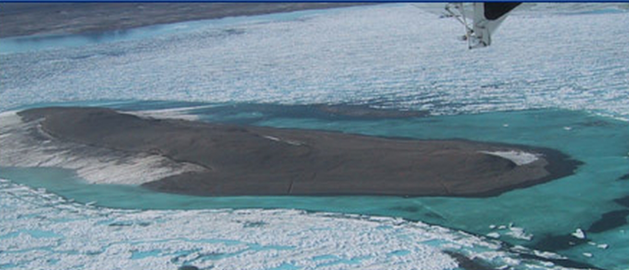
ไฟล, kaffeklubben, island, aerial, photo, ไฟล, ประว, ไฟล, หน, าท, ภาพน, การใช, ไฟล, วนกลางขนาดของต, วอย, างน, กเซล, ความละเอ, ยดอ, กเซล, กเซล, กเซล, ภาพท, ความละเอ, ยดส, งกว, 8206, กเซล, ขนาดไฟล, โลไบต, ชน, ดไมม, image, jpeg, ปภาพหร, อไฟล, เส, ยงน, นฉบ, บอย, ค. ifl prawtiifl hnathimiphaphni karichiflswnklangkhnadkhxngtwxyangni 800 343 phikesl khwamlaexiydxun 320 137 phikesl 640 275 phikesl 1 280 549 phikesl duphaphthimikhwamlaexiydsungkwa 8206 1 280 549 phikesl khnadifl 312 kiolibt chnidimm image jpeg rupphaphhruxiflesiyngni tnchbbxyuthi khxmmxns raylaexiyddanlang epnkhxkhwamthiaesdngphlcak ifltnchbbinkhxmmxns khxmmxnsepnewbistinokhrngkarsahrbekbrwbrwmsuxesri thi khunsamarthchwyid khwamyx khaxthibayKaffeklubben island aerial photo jpg English Aerial photo of Kaffeklubben Island near the northern shores of Greenland See also description in a blog Russkij Aerofotosnimok ostrova Kaffeklubben bliz severnogo poberezhya Grenlandii aehlngthima The file at Flickr Aerial Image of Kaffeklubben Island Mod Mr Minton from San Diego USphusrangsrrkh Not mentioned at the sourcekarxnuyat karichiflniihm iflnixyuphayitsyyaxnuyatkhriexthifkhxmmxns run aesdngthima 2 0 thwipkhunsamarth thicaaebngpn thicathasaena aeckcay aelasngngandngklawtxip thicaeriyberiyngihm thicaddaeplngngandngklaw phayitenguxnikhtxipni aesdngthima khuntxngihekiyrtiecakhxngnganxyangehmaasm odyephimlingkipyngsyyaxnuyat aelarabuhakmikarepliynaeplng khunxacthaechnniidinrupaebbidkidtamkhwr aettxngimichinlksnathiaenawaphuihxnuyatsnbsnunkhunhruxkarichngankhxngkhunhttps creativecommons org licenses by 2 0 CC BY 2 0 Creative Commons Attribution 2 0 true true karxnuyatichsiththi This image was originally posted to Flickr by EVS Islands at https www flickr com photos 60042877 N00 2898835456 It was reviewed on 23 singhakhm ph s 2557 by FlickreviewR and was confirmed to be licensed under the terms of the cc by 2 0 23 singhakhm ph s 2557khabrryayodyyxithyephimkhabrryaythrrthdediywephuxkhyaykhwamwaiflnimixairixethmthiaesdngxyuiniflniprakxbdwyekaakhaefxkhluepinphusrangbangkhathiimmiixethmwikisnethschuxphusrangsrrkh Not mentioned at the sourcesthanalikhsiththimilikhsiththisyyaxnuyatCreative Commons Attribution 2 0 Generic xngkvsMIME type xngkvsimage jpeg prawtiifl khlikwnthi ewlaephuxduiflthipraktinkhnann wnthi ewlarupyxkhnadphuichkhwamehn pccubn19 37 23 singhakhm 25571 280 549 312 kiolibt DmitTrixUser created page with UploadWizard hnathimiphaphni hnatxipni oyngmathiphaphni ekaakhaefxkhluepin karichiflswnklang wikixuntxipniichiflni karichbn arz wikipedia org كافيكلوبين karichbn bg wikipedia org Kafekluben karichbn ca wikipedia org Illa Kaffeklubben karichbn ceb wikipedia org Inuit Qeqertaat karichbn cs wikipedia org Kaffeklubben karichbn cu wikipedia org Kafyekloubyen karichbn da wikipedia org Bruger Steenth Autoliste Gronlandske objekter karichbn de wikipedia org Kaffeklubben Insel Nordlichste Insel der Erde karichbn en wikipedia org Kaffeklubben Island Northernmost point of land karichbn en wikivoyage org Northeast Greenland National Park karichbn eo wikipedia org Kaffeklubben karichbn es wikipedia org Kaffeklubben karichbn es wikivoyage org Registros geograficos karichbn fi wikipedia org Kaffeklubben karichbn fr wikipedia org Kaffeklubben karichbn he wikipedia org קאפקלובן karichbn id wikipedia org Pulau Kaffeklubben karichbn it wikipedia org Kaffeklubben karichbn ja wikipedia org カフェクルベン島 地球最北の陸地 karichbn ko wikipedia org 카페클루벤섬 karichbn lt wikipedia org Kafeklubenas karichbn lv wikipedia org Kafeklubena karichbn ml wikipedia org ക ഫ ക ലബ ദ വ പ karichbn nl wikipedia org Kaffeklubbeneiland karichbn nn wikipedia org Kaffeklubben karichbn no wikipedia org Kaffeklubboya karichbn pl wikipedia org Kaffeklubben karichbn pt wikipedia org Kaffeklubben karichbn ro wikipedia org Insula Kaffeklubben karichbn ru wikipedia org Kaffeklubben Koh Lauge karichbn simple wikipedia org User Tymewalk Kaffeklubben Island Kaffeklubben Island karichbn sr wikipedia org Kafekluben karichbn sv wikipedia org Kaffeklubben Anvandare Steenth autoliste Gronlands nationalpark p131 karichbn ta wikipedia org க ஃப க ல ப ன த வ karichbn tr wikipedia org Kaffeklubben Adasi karichbn uk wikipedia org Kafeklubben Lauge Koh karichbn www wikidata org Q826471 karichbn zh yue wikipedia org 卡啡古賓島 karichbn zh wikipedia org 卡菲克卢本岛 ekhathungcak https th wikipedia org wiki ifl Kaffeklubben island aerial photo jpg, wikipedia, วิกิ หนังสือ, หนังสือ, ห้องสมุด,