This file is derivated from File:Japan map.png. The source and authors of the original map are as follow:
Original file: Koba-chan and depending on time of crop perhaps also (see original file): Kon, Rai koku, 赤鉛筆, JYOQ2, 月夜野ほたる, 139, 国鉄115系湘南色, BigBang19, そらみみ and たくやばすけくん
Original data: National Institute of Geosciences, Ministry of Land, Infrastructure, Transport and Tourism (国土交通省国土地理院(旧建設省 国土地理院))
The original file is licensed {{GFDL}} and {{Cc-by-sa-3.0}}. The changes made based on the original file are as follow: Minor changes are {{PD-ineligible}} meaning the file is GFDL and Cc-by-sa-3.0. Bigger changes made before August 1, 2009 or after September 30, 2020 are licensed GFDL and Cc-by-sa-3.0 like the original file. Bigger changes made by the uploader between August 1, 2009 and September 30, 2020 (inclusive) are licensed GFDL only. In some cases the uploader added further licenses for the changes and in that case the licenses are specified below. ป้ายนี้มิใช่ป้ายแสดงสถานะลิขสิทธิ์ ดังนั้นการระบุสถานะลิขสิทธิ์จึงต้องกระทำแยกต่างหาก ดูที่ Commons:Lincensing
{{Information| |Description=Map of Ashigarakami District, Kanagawa, Japan |Source= ja:Map kanagawa ashigarakami district p01-01.png on Japanese Wikipedia |Date=2008-12-28 |Author=okia on Japanese Wikipedia |Permission={{GFDL-ja}} |o
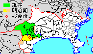
ไฟล, kanagawa, ashigarakami, ไฟล, ประว, ไฟล, หน, าท, ภาพน, การใช, ไฟล, วนกลางไม, ภาพท, รายละเอ, ยดส, งกว, าน, kanagawa, ashigarakami, 8206, กเซล, ขนาดไฟล, โลไบต, ชน, ดไมม, image, ปภาพหร, อไฟล, เส, ยงน, นฉบ, บอย, คอมมอนส, รายละเอ, ยดด, านล, าง, เป, นข, อความท, . ifl prawtiifl hnathimiphaphni karichiflswnklangimmiphaphthimiraylaexiydsungkwani Kanagawa AshigaraKami gun png 8206 190 110 phikesl khnadifl 4 kiolibt chnidimm image png rupphaphhruxiflesiyngni tnchbbxyuthi khxmmxns raylaexiyddanlang epnkhxkhwamthiaesdngphlcak ifltnchbbinkhxmmxns khxmmxnsepnewbistinokhrngkarsahrbekbrwbrwmsuxesri thi khunsamarthchwyid khwamyx khaxthibayKanagawa AshigaraKami gun png English Map of Ashigarakami District Kanagawa Japan 日本語 神奈川県足柄上郡の範囲 緑色が現在の範囲 1 中井町 2 大井町 3 松田町 4 山北町 5 開成町 黄色が明治時代中期の範囲 wnthi 29 thnwakhm ph s 2551 aehlngthima Map kanagawa ashigarakami district p01 01 png と JpLargeMap KantoTokai png を元に投稿者が作成 phusrangsrrkh 改変元 著作権 使用制限テンプレート参照 改変部分 アップロード者 karxnuyat karichiflniihm This file is derivated from File Japan map png The source and authors of the original map are as follow Original file Koba chan and depending on time of crop perhaps also see original file Kon Rai koku 赤鉛筆 JYOQ2 月夜野ほたる 139 国鉄115系湘南色 BigBang19 そらみみ and たくやばすけくん Original data National Institute of Geosciences Ministry of Land Infrastructure Transport and Tourism 国土交通省国土地理院 旧建設省 国土地理院 The original file is licensed GFDL and Cc by sa 3 0 The changes made based on the original file are as follow Minor changes are PD ineligible meaning the file is GFDL and Cc by sa 3 0 Bigger changes made before August 1 2009 or after September 30 2020 are licensed GFDL and Cc by sa 3 0 like the original file Bigger changes made by the uploader between August 1 2009 and September 30 2020 inclusive are licensed GFDL only In some cases the uploader added further licenses for the changes and in that case the licenses are specified below paynimiichpayaesdngsthanalikhsiththi dngnnkarrabusthanalikhsiththicungtxngkrathaaeyktanghak duthi Commons Lincensing karxnuyatichsiththi khapheca inthanaphuthuxlikhsiththikhxngphaphhruxsuxni xnuyatihichphaphhruxsuxniphayitenguxnikhtxipni xnuyatihkhdlxk aeckcayaela hruxddaeprexksarniphayitenguxnikhkhxngsyyaxnuyatexksaresrikhxngknu run 1 2 hruxrunid nbcaknithixxkodymulnithisxftaewresri odyimmiswnidhamaekikh immikhxkhwampkhnaaelapkhlng saenakhxngsyyaxnuyatrwmxyuinswnchux syyaxnuyatexksaresrikhxngknuhttp www gnu org copyleft fdl html GFDL GNU Free Documentation License true trueiflnixyuphayitsyyaxnuyat khriexthifkhxmmxns aebbaesdngthima xnuyataebbediywkn 3 0 tnchbbkhunsamarth thicaaebngpn thicathasaena aeckcay aelasngngandngklawtxip thicaeriyberiyngihm thicaddaeplngngandngklaw phayitenguxnikhtxipni aesdngthima khuntxngihekiyrtiecakhxngnganxyangehmaasm odyephimlingkipyngsyyaxnuyat aelarabuhakmikarepliynaeplng khunxacthaechnniidinrupaebbidkidtamkhwr aettxngimichinlksnathiaenawaphuihxnuyatsnbsnunkhunhruxkarichngankhxngkhun xnuyataebbediywkn hakkhunddaeplng epliynrup hruxtxetimnganni khuntxngichsyyaxnuyataebbediywknhruxaebbthiehmuxnkbsyyaxnuyatthiichkbnganniethannhttps creativecommons org licenses by sa 3 0 CC BY SA 3 0 Creative Commons Attribution Share Alike 3 0 true truekhunsamartheluxksyyaxnuyatdngklawtamtxngkar bnthukkarxphohld The original description page was here All following user names refer to ja wikipedia 2014 03 22 17 53 検見川町 190 110 3717 bytes 他県と縮尺を合わせて全面改訂 2008 12 28 15 22 Okia 420 210 13835 bytes 2008 12 20 20 58 Okia 420 210 11185 bytes Ma Information Description 明治時代中頃の足柄上郡 Source Map kanagawa ashigarakami district p01 01 png を元に投稿者が作成 Date 20081221 Author okia Permission GFDL other versions 2008 12 20 20 43 Okia 420 210 11200 bytes Ma Information Description 明治時代中頃の足柄上郡 Source Map kanagawa ashigarakami district p01 01 png を元に投稿者が作成 Date 20081221 Author okia Permission GFDL other versions 2004 08 04 20 01 Tai i 420 210 8001 bytes 神奈川県足柄上郡の位置図 420x210 8KB 7khabrryayodyyxithyephimkhabrryaythrrthdediywephuxkhyaykhwamwaiflnimixairixethmthiaesdngxyuiniflniprakxbdwysthanalikhsiththimilikhsiththisyyaxnuyatGNU Free Documentation License version 1 2 or lateral nbsp xngkvsCreative Commons Attribution ShareAlike 3 0 Unported nbsp xngkvswnthisrang wnkxtng29 thnwakhm 2008 prawtiifl khlikwnthi ewlaephuxduiflthipraktinkhnann lasud ekasud du ihmkwa 10 ekakwa 10 10 20 50 100 250 500 wnthi ewlarupyxkhnadphuichkhwamehn pccubn14 59 7 tulakhm 2563190 110 4 kiolibt OgreBot BOT Reverting to most recent version before archival 14 59 7 tulakhm 2563420 210 11 kiolibt OgreBot BOT Uploading old version of file from ja wikipedia originally uploaded on 2008 12 20 20 58 44 by Okia 14 58 7 tulakhm 2563420 210 11 kiolibt OgreBot BOT Uploading old version of file from ja wikipedia originally uploaded on 2008 12 20 20 43 38 by Okia 14 58 7 tulakhm 2563420 210 8 kiolibt OgreBot BOT Uploading old version of file from ja wikipedia originally uploaded on 2004 08 04 20 01 05 by Tai i 12 46 10 emsayn 2557190 110 4 kiolibt 検見川町他県と縮尺を合わせて全面改訂 00 53 23 minakhm 2557190 110 4 kiolibt 検見川町他県と縮尺を合わせて全面改訂 09 09 13 singhakhm 2552420 210 14 kiolibt MChew Information Description Map of Ashigarakami District Kanagawa Japan Source ja Map kanagawa ashigarakami district p01 01 png on Japanese Wikipedia Date 2008 12 28 Author okia on Japanese Wikipedia Permission GFDL ja o 22 22 28 thnwakhm 2551420 210 14 kiolibt OkiaSuppressed comment removed by FileImporter 03 58 21 thnwakhm 2551420 210 11 kiolibt OkiaMa Information Description 明治時代中頃の足柄上郡 Source Map kanagawa ashigarakami district p01 01 png を元に投稿者が作成 Date 20081221 Author okia Permission GFDL other versions 03 43 21 thnwakhm 2551420 210 11 kiolibt OkiaMa Information Description 明治時代中頃の足柄上郡 Source Map kanagawa ashigarakami district p01 01 png を元に投稿者が作成 Date 20081221 Author okia Permission GFDL other versions lasud ekasud du ihmkwa 10 ekakwa 10 10 20 50 100 250 500 hnathimiphaphni hnatxipni oyngmathiphaphni xaephxxachingarakami karichiflswnklang wikixuntxipniichiflni karichbn en wikipedia org Ashigarakami District Kanagawa karichbn fa wikipedia org شهرستان آشیگاراکامی کاناگاوا karichbn fr wikipedia org District d Ashigarakami karichbn ja wikipedia org 足柄上郡 karichbn ko wikipedia org 아시가라카미군 아이코군 karichbn ru wikipedia org Asigarakami karichbn uk wikipedia org Povit Asigara Kami karichbn www wikidata org Q1202540 ekhathungcak https th wikipedia org wiki ifl Kanagawa AshigaraKami gun png, wikipedia, วิกิ หนังสือ, หนังสือ, ห้องสมุด,