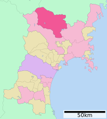
English: Location of Kurihara in Miyagi Prefecture
วันที่
22 กันยายน พ.ศ. 2550 (original upload date)
แหล่งที่มา
Original file: งานของตัว
Data: 国土交通省 国土数値情報(行政区域(N03)・湖沼(W09))
ผู้สร้างสรรค์
Lincun at ja.wikipedia
การอนุญาต (การใช้ไฟล์นี้ใหม่)
This file is a map of a municipality in Japan created and uploaded by Lincun on Japanese Wikipedia. It may also be a file based on one of these maps (see info in file history or author field for more info on later editors). Source:
English: Data used : Ministry of Land, Infrastructure, Transport and Tourism - National Land Numerical Information (Administrative Area (N03) / Lake (W09))
日本語: 使用データ : 国土交通省 国土数値情報(行政区域(N03)・湖沼(W09))
The original file was licensed {{GFDL}} and {{Cc-by-sa-3.0}}. See this category for more files like this. ป้ายนี้มิใช่ป้ายแสดงสถานะลิขสิทธิ์ ดังนั้นการระบุสถานะลิขสิทธิ์จึงต้องกระทำแยกต่างหาก ดูที่ Commons:Lincensing
ไฟล, kurihara, miyagi, prefecture, ไฟล, ประว, ไฟล, หน, าท, ภาพน, การใช, ไฟล, วนกลาง, อม, ลเก, ยวก, บภาพขนาดของต, วอย, าง, ของไฟล, กเซล, ความละเอ, ยดอ, กเซล, กเซล, กเซล, กเซล, กเซล, ภาพท, ความละเอ, ยดส, งกว, 8206, ไฟล, กเซล, ขนาดไฟล, โลไบต, ปภาพหร, อไฟล, เส, ยง. ifl prawtiifl hnathimiphaphni karichiflswnklang khxmulekiywkbphaphkhnadkhxngtwxyang PNG nikhxngifl SVG ni 484 538 phikesl khwamlaexiydxun 216 240 phikesl 432 480 phikesl 691 768 phikesl 921 1 024 phikesl 1 842 2 048 phikesl duphaphthimikhwamlaexiydsungkwa 8206 ifl SVG 484 538 phikesl khnadifl 8 kiolibt rupphaphhruxiflesiyngni tnchbbxyuthi khxmmxns raylaexiyddanlang epnkhxkhwamthiaesdngphlcak ifltnchbbinkhxmmxns khxmmxnsepnewbistinokhrngkarsahrbekbrwbrwmsuxesri thi khunsamarthchwyid khwamyx khaxthibayKurihara in Miyagi Prefecture Ja svg 日本語 宮城県栗原市位置図 English Location of Kurihara in Miyagi Prefecture wnthi 22 knyayn ph s 2550 original upload date aehlngthima Original file ngankhxngtw Data 国土交通省 国土数値情報 行政区域 N03 湖沼 W09 phusrangsrrkh Lincun at ja wikipedia karxnuyat karichiflniihm This file is a map of a municipality in Japan created and uploaded by Lincun on Japanese Wikipedia It may also be a file based on one of these maps see info in file history or author field for more info on later editors Source English Data used nbsp Ministry of Land Infrastructure Transport and Tourism National Land Numerical Information Administrative Area N03 Lake W09 日本語 使用データ nbsp 国土交通省 国土数値情報 行政区域 N03 湖沼 W09 The original file was licensed GFDL and Cc by sa 3 0 See this category for more files like this paynimiichpayaesdngsthanalikhsiththi dngnnkarrabusthanalikhsiththicungtxngkrathaaeyktanghak duthi Commons Lincensing karxnuyatichsiththi xnuyatihkhdlxk aeckcayaela hruxddaeprexksarniphayitenguxnikhkhxngsyyaxnuyatexksaresrikhxngknu run 1 2 hruxrunid nbcaknithixxkodymulnithisxftaewresri odyimmiswnidhamaekikh immikhxkhwampkhnaaelapkhlng saenakhxngsyyaxnuyatrwmxyuinswnchux syyaxnuyatexksaresrikhxngknuhttp www gnu org copyleft fdl html GFDL GNU Free Documentation License true true iflnixyuphayitsyyaxnuyat khriexthifkhxmmxns aebbaesdngthima xnuyataebbediywkn 3 0 tnchbbkhunsamarth thicaaebngpn thicathasaena aeckcay aelasngngandngklawtxip thicaeriyberiyngihm thicaddaeplngngandngklaw phayitenguxnikhtxipni aesdngthima khuntxngihekiyrtiecakhxngnganxyangehmaasm odyephimlingkipyngsyyaxnuyat aelarabuhakmikarepliynaeplng khunxacthaechnniidinrupaebbidkidtamkhwr aettxngimichinlksnathiaenawaphuihxnuyatsnbsnunkhunhruxkarichngankhxngkhun xnuyataebbediywkn hakkhunddaeplng epliynrup hruxtxetimnganni khuntxngichsyyaxnuyataebbediywknhruxaebbthiehmuxnkbsyyaxnuyatthiichkbnganniethannhttps creativecommons org licenses by sa 3 0 CC BY SA 3 0 Creative Commons Attribution Share Alike 3 0 true true bnthukkarxphohld The original description page was here All following user names refer to ja wikipedia 2007 09 22 00 46 Lincun 600 752 0 16087 bytes 基礎自治体位置図画像情報 宮城県 栗原市 This file was moved from Japanese Wikipedia See below for original file information File name 基礎自治体位置図 04213 svg Description 基礎自治体位置図画像情報 宮城県 栗原市 20090901 File history wnthi ewla UTC khnad phuich khwamehn 22 knyayn ph s 2550 00 46 26 600x752 Lincun 基礎自治体位置図画像情報 宮城県 栗原市 4 tulakhm ph s 2552 05 34 23 484x538 Lincun 基礎自治体位置図画像情報 宮城県 栗原市 20090901 Page history wnthi ewla UTC Flag phuich khwamyx 22 knyayn ph s 2550 00 46 26 Lincun 基礎自治体位置図画像情報 宮城県 栗原市 5 kumphaphnth ph s 2551 17 09 28 Arthena now on commons 4 tulakhm ph s 2552 05 34 23 Lincun ファイル 基礎自治体位置図 04213 svg の新しい版をアップロードしました 基礎自治体位置図画像情報 宮城県 栗原市 20090901 4 tulakhm ph s 2552 05 37 15 Lincun Deutsch nbsp English nbsp makedonski nbsp 한국어 nbsp 日本語 nbsp فارسی nbsp khabrryayodyyxithyephimkhabrryaythrrthdediywephuxkhyaykhwamwaiflnimixairixethmthiaesdngxyuiniflniprakxbdwysthanalikhsiththimilikhsiththisyyaxnuyatCreative Commons Attribution ShareAlike 3 0 Unported nbsp xngkvsGNU Free Documentation License version 1 2 or later nbsp xngkvswnthisrang wnkxtng22 knyayn 2007 prawtiifl khlikwnthi ewlaephuxduiflthipraktinkhnann wnthi ewlarupyxkhnadphuichkhwamehn pccubn21 54 3 thnwakhm 2552484 538 8 kiolibt MonanekoUpdate 2009 10 04 00 08 6 kumphaphnth 2551600 752 16 kiolibt Arthena Information Description ja 概要 宮城県栗原市位置図 作成者 Lincun 使用データ 国土交通省 国土数値情報 行政区域 N03 湖沼 W09 en Location of Kurihara in Miyagi Prefecture Source Transferred from hnathimiphaphni hnatxipni oyngmathiphaphni khurihara karichiflswnklang wikixuntxipniichiflni karichbn ar wikipedia org كوريهارا مياغي karichbn azb wikipedia org کوریهارا میاقی karichbn ce wikipedia org Kurihara gӀala karichbn de wikipedia org Kurihara karichbn en wikipedia org Kurihara Miyagi Miyagi Prefecture karichbn es wikipedia org Kurihara Miyagi karichbn fa wikipedia org کوریهارا میاگی karichbn fi wikipedia org Kurihara karichbn gl wikipedia org Kurihara karichbn id wikipedia org Kurihara Miyagi karichbn it wikipedia org Kurihara karichbn ja wikipedia org 栗原市 karichbn ko wikipedia org 구리하라시 karichbn mzn wikipedia org کوریهارا میاگی karichbn nl wikipedia org Kurihara karichbn no wikipedia org Kurihara karichbn pl wikipedia org Prefektura Miyagi karichbn ro wikipedia org Kurihara karichbn sv wikipedia org Kurihara Miyagi karichbn tg wikipedia org Kuriҳara karichbn tt wikipedia org Kurihara shәһәr karichbn uk wikipedia org Kurihara Miyagi karichbn vi wikipedia org Miyagi Kurihara Miyagi karichbn www wikidata org Q469189 karichbn zh classical wikipedia org 栗原市 karichbn zh min nan wikipedia org Kurihara chhi karichbn zh wikipedia org 栗原市khxmulekiywkbphaph phaphnimikhxmulephimetim sungswnihymacakklxngdicitxlhruxsaeknenxrthisamarthekbkhxmuldngklawiwrwmkbphaphid thaphaphnithukprbprungaekikhhruxepliynaeplngcakedim khxmulbangxyangcayngkhngimepliynaeplngehmuxnphaphthithukprbprungaekikhnnchuxeruxngsn宮城県栗原市位置図 2009年9月1日 chuxphaphAuthor Lincun ekhathungcak https th wikipedia org wiki ifl Kurihara in Miyagi Prefecture Ja svg, wikipedia, วิกิ หนังสือ, หนังสือ, ห้องสมุด,