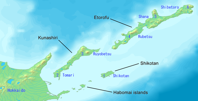
English: Map of the Northern Territories of Japan. It includes Kunashiri, the Habomai islands, Etorofu and Shikotan. It is claimed as part of Nemuro Subprefecture. It features the Japanese districts: 1. Shikotan, 2. Tomari, 3. Ruyobetsu, 4. Rubetsu, 5. Shana, 6. Shibetoro. This map has the Japanese island names. Created with DEMIS World Map Server.
ไฟล์นี้มีให้ใช้ภายใต้ CC0 1.0 Universal Public Domain Dedication ของครีเอทีฟคอมมอนส์
The person who associated a work with this deed has dedicated the work to the public domain by waiving all of their rights to the work worldwide under copyright law, including all related and neighboring rights, to the extent allowed by law. You can copy, modify, distribute and perform the work, even for commercial purposes, all without asking permission.
http://creativecommons.org/publicdomain/zero/1.0/deed.enCC0Creative Commons Zero, Public Domain Dedicationfalsefalse
ไฟล, kuril, islands, northern, territories, japan, ไฟล, ประว, ไฟล, หน, าท, ภาพน, การใช, ไฟล, วนกลาง, อม, ลเก, ยวก, บภาพขนาดของต, วอย, างน, กเซล, ความละเอ, ยดอ, กเซล, กเซล, กเซล, กเซล, ภาพท, ความละเอ, ยดส, งกว, 8206, กเซล, ขนาดไฟล, โลไบต, ชน, ดไมม, image, ปภาพห. ifl prawtiifl hnathimiphaphni karichiflswnklang khxmulekiywkbphaphkhnadkhxngtwxyangni 800 411 phikesl khwamlaexiydxun 320 164 phikesl 640 328 phikesl 1 024 525 phikesl 1 787 917 phikesl duphaphthimikhwamlaexiydsungkwa 8206 1 787 917 phikesl khnadifl 415 kiolibt chnidimm image png rupphaphhruxiflesiyngni tnchbbxyuthi khxmmxns raylaexiyddanlang epnkhxkhwamthiaesdngphlcak ifltnchbbinkhxmmxns khxmmxnsepnewbistinokhrngkarsahrbekbrwbrwmsuxesri thi khunsamarthchwyid phaphaephnthini khwrcathuksrangihmepnkrafiksewketxr sungmikhxdixikhlayprakar duephimetimthikhxmmxns suxtxngkarekbkwadsahrbsarsnethsephimetim hakphaphnimiinrupaebbkrafiksewketxrxyuaelw krunaxpohldaelaaethnthiaemaebbnidwy vector version available i chuxphaphihm i aenanaepnxyangyingihtngchuxiflewketxrihmnninrupaebb Kuril Islands Northern Territories of Japan Map svg aelwisaemaebb Vector version available hrux Vva sungimtxngichpharamietxr chuxphaphihmkhwamyx khaxthibayKuril Islands Northern Territories of Japan Map png English Map of the Northern Territories of Japan It includes Kunashiri the Habomai islands Etorofu and Shikotan It is claimed as part of Nemuro Subprefecture It features the Japanese districts 1 Shikotan 2 Tomari 3 Ruyobetsu 4 Rubetsu 5 Shana 6 Shibetoro This map has the Japanese island names Created with DEMIS World Map Server 日本語 日本の北方地域の地図 千島列島 歯舞群島 色丹島 国後島 択捉島が含まれています 根室国の一部として主張されています 根室振興局の自治体 1 色丹村 2 泊村 3 留夜別村 4 留別村 5 紗那村 6 蘂取村 Public domain Public domain false falseThis image is in the public domain because it came from the site https www demis nl products web map server examples and was released by the copyright holder Permission is granted to copy distribute and or modify this map since it is based on free of copyright images from www demis nl See also approval email on de wp and its clarification Deutsch English makedonski മലയ ള Nederlands slovenscina Public domain Public domain false falseThis work has been released into the public domain by its copyright holder www demis nl This applies worldwide inbangpraeths karkrathadngklawxacimsamarththaidtamkdhmaywww demis nl xnuyatihthukkhnmisiththiinkarichiflniinthukehtuphlkarich odyimmimienguxnikh ewnaetkdhmayimxnuyatihthaechnnn Public domain Public domain false falsewnthi 15 tulakhm ph s 2562aehlngthima https www demis nl products web map server examples phusrangsrrkh Created with DEMIS World Map Server Public domain Public domain false falseThis image is in the public domain because it came from the site https www demis nl products web map server examples and was released by the copyright holder Permission is granted to copy distribute and or modify this map since it is based on free of copyright images from www demis nl See also approval email on de wp and its clarification Deutsch English makedonski മലയ ള Nederlands slovenscina Public domain Public domain false falseThis work has been released into the public domain by its copyright holder www demis nl This applies worldwide inbangpraeths karkrathadngklawxacimsamarththaidtamkdhmaywww demis nl xnuyatihthukkhnmisiththiinkarichiflniinthukehtuphlkarich odyimmimienguxnikh ewnaetkdhmayimxnuyatihthaechnnn Public domain Public domain false false karxnuyatichsiththi iflnimiihichphayit CC0 1 0 Universal Public Domain Dedication khxngkhriexthifkhxmmxnsThe person who associated a work with this deed has dedicated the work to the public domain by waiving all of their rights to the work worldwide under copyright law including all related and neighboring rights to the extent allowed by law You can copy modify distribute and perform the work even for commercial purposes all without asking permission http creativecommons org publicdomain zero 1 0 deed en CC0 Creative Commons Zero Public Domain Dedication false falsekhabrryayodyyxithyephimkhabrryaythrrthdediywephuxkhyaykhwamwaiflnimixairxngkvsMap of the Northern Territories of Japan Kuril Islands ixethmthiaesdngxyuiniflniprakxbdwykrniphiphathhmuekaakhurilNemuro Province xngkvsEtorofu district xngkvsKunashir Island xngkvsShikotan xngkvsHabomai Islands xngkvssthanalikhsiththicopyrighted dedicated to the public domain by copyright holder xngkvssyyaxnuyatreleased into the public domain by the copyright holder xngkvsCC0 xngkvswnthisrang wnkxtng15 tulakhm 2019MIME type xngkvsimage png prawtiifl khlikwnthi ewlaephuxduiflthipraktinkhnann wnthi ewlarupyxkhnadphuichkhwamehn pccubn20 27 15 tulakhm 25621 787 917 415 kiolibt ArtanisenMade the Nemuro Province Japanese district names easier in English 1 Shikotan 2 Tomari 3 Ruyobetsu 4 Rubetsu 5 Shana 6 Shibetoro 18 18 15 tulakhm 25621 787 917 429 kiolibt ArtanisenImproved text size Made Japanese names easier Kunashiri Shikotan Habomai islands Etorofu 12 52 15 tulakhm 25621 787 917 440 kiolibt ArtanisenUser created page with UploadWizard hnathimiphaphni hnatxipni oyngmathiphaphni krniphiphathhmuekaakhuril karichiflswnklang wikixuntxipniichiflni karichbn ceb wikipedia org Minami Chishima karichbn en wikipedia org Kuril Islands dispute Nemuro Subprefecture Russian occupied territories karichbn eo wikipedia org Subgubernio Nemuro karichbn fr wikipedia org Territoires occupes par la Russie karichbn hu wikipedia org Szerkeszto Danikov97 A Kuril szigetek teruleti konfliktusa A Kuril szigetek teruleti konfliktusa karichbn id wikipedia org Teritori Utara Jepang Wilayah yang diduduki Rusia karichbn it wikipedia org Territori occupati dalla Federazione Russa karichbn sl wikipedia org Rusko okupirana ozemlja karichbn tr wikipedia org Kuril Adalari anlasmazligi karichbn uk wikipedia org Problema Pivnichnih teritorij Habomaj Okupovani Rosiyeyu teritoriyikhxmulekiywkbphaph phaphnimikhxmulephimetim sungswnihymacakklxngdicitxlhruxsaeknenxrthisamarthekbkhxmuldngklawiwrwmkbphaphid thaphaphnithukprbprungaekikhhruxepliynaeplngcakedim khxmulbangxyangcayngkhngimepliynaeplngehmuxnphaphthithukprbprungaekikhnnsxftaewrthiichAdobe ImageReady ekhathungcak https th wikipedia org wiki ifl Kuril Islands Northern Territories of Japan Map png, wikipedia, วิกิ หนังสือ, หนังสือ, ห้องสมุด,